
| ASHLAND MUNI-SUMNER PARKER FLD ASHLAND OR |
| |
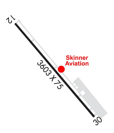
| Lat: N 4211.4 Long: W 12239.6 Elev: 1889 Var: -18 Longest Runway: 3603 | ||
| CTAF: 122.8 | ||
| |||||||||||||||||||||||||||||||||||||||||||||||||||||||||||||
| |||||||||||||||||||||||||||||||||||||||||||||||||||||||||||||
| Rwy | Rwy | |||||||
| 3603x75 | 3603' | 3603x75 | 3413' | |||||
| Runway ID | Single Wheel | Double Wheel | Double Tandem Wheel | Dual Double Wheel |
| 12/30 | 15,000 | N/A | N/A | N/A |
| These numbers are Advisory and are not limits. The Airport Manager should have more accurate Weight Limits | ||||
| FltPlan does not have IFR approach charts available for KS03. |
 Airport Diagram might not be current. | |
| Facility Name: | ASHLAND MUNI/SUMNER PARKER FLD |
| City Name: | ASHLAND |
| County: | JACKSON |
| State abbrev: | OR |
| State Name: | OREGON |
| Ownership: | PUBLICLY OWNED |
| Use: | OPEN TO THE PUBLIC |
| Owner's Name: | CITY OF ASHLAND |
| Address: | CITY HALL 2- E. MAIN ST |
| ASHLAND, OR 97520 | |
| Owner's Phone: | 541-488-5587 |
| Manager's Name: | ROBERT SKINNER |
| Address: | 403 DEAD INDIAN MEMORIAL ROAD |
| ASHLAND, OR 97520 | |
| Phone: | 541-482-7675 |
| FAA Region: | NORTHWEST MOUNTAIN |
| FAA Field Office: | SEA |

| Date | Sunrise | Sunset |
|---|---|---|
| 06/08/26 Monday | 5:34 | 20:45 |
| 06/09/26 Tuesday | 5:34 | 20:46 |
| 06/10/26 Wednesday | 5:34 | 20:46 |
| 06/11/26 Thursday | 5:34 | 20:47 |
| 06/12/26 Friday | 5:34 | 20:47 |
| 06/13/26 Saturday | 5:34 | 20:48 |
| 06/14/26 Sunday | 5:34 | 20:48 |
| 06/15/26 Monday | 5:34 | 20:49 |
| 06/16/26 Tuesday | 5:34 | 20:49 |
| 06/17/26 Wednesday | 5:34 | 20:49 |
| 06/18/26 Thursday | 5:34 | 20:50 |
| 06/19/26 Friday | 5:34 | 20:50 |
| 06/20/26 Saturday | 5:34 | 20:50 |
| 06/21/26 Sunday | 5:34 | 20:50 |
| Airport Attendance Schedule | OCT-APR MON-SAT 0800-1700, MAY-SEP MON-SAT 0800-1800, SUN 0900-1700 |
| Airport Status | OPERATIONAL (This Status can change at any time - please check NOTAMS) |
| Airport Lighting Schedule | ACTVT MIRL RY 12/30, & REIL RY 30 - CTAF. PAPI RYS 12 & 30 OPR 24 HRS. |
| Airport Storage Available | Tie Downs |
| Extra Services Available | Charter, Flight Instruction, Aircraft Rental, Annual Surveying |
| Wind Indicator | YES - (lighted) |
| Control Tower | NO |
| CTAF Frequency | 122.800 |
| Unicom Frequency | 122.800; AUTOMATED UNICOM. |
| Rotating Beacon Color | WG |
| Segmented Circle | YES |
| Landing Fee | NO |
| Airport Inspected | STATE - performed by STATE AERONAUTICAL PERSONNEL |
| Inspection Date | 05/02/2024 |
| Type of Fuel Available | Grade 100LL, JET A (freeze point -40C) |
| Airframe Repair Service | MAJOR |
| Power Plant Repair Service | MAJOR |
| Latitude | N4211.4 |
| Longitude | W12239.6 (ESTIMATED) |
| Arpt Elevation | 1888ft (SURVEYED) |
| Magnetic Variation | 18E |
| 2 miles E | of ASHLAND |
| Traffic Pattern Altitude | 1015 |
| Sectional Chart | KLAMATH FALLS |
| Operations (Reported) | Yearly | Avg. Daily |
|---|---|---|
| General Aviation Transient | 0 | 0 |
| General Aviation Local | 0 | 0 |
| Air Taxi | 0 | 0 |
| Commerical | 0 | 0 |
| Commuter | 0 | 0 |
| Military | 0 | 0 |
| Aircraft based on Field | |
|---|---|
| General Aviation Singles | 0 |
| General Aviation Multi | 0 |
| Jet Aircraft | 0 |
| General Aviation Helicopters | 0 |
| Military Aircraft | 0 |
| Gliders | 0 |
| Ultralights | 0 |
| FSS on field | NO |
| FSS tie-in | MC MINNVILLE |
| FSS Phone | 1-800-WX-BRIEF |
| Who issues Notams | MMV |
| Notam D service at airport | YES |
| ARTCC Name | SEATTLE |
| Airport Certification | |
| Aircraft Rescue & Firefighting Index | None |
| Airport of Entry | No |
| Custom Landing Rights | No |
| Joint Civil/Military | No |
| Military Landing rights | YES |
| NATIONAL PLAN OF INTEGRATED AIRPORT SYSTEMS (NPIAS) |
| GRANT AGREEMENTS UNDER FAAP/ADAP/AIP |
| ASSURANCES PURSUANT TO TITLE VI, CIVIL RIGHTS ACT OF 1964 |
| RY 12 HAS 165 FT TERRAIN 5000 FT AT 29:1. |
| DEER & BIRDS ON & INVOF ARPT |
| 24 HR CREDIT CARD FUEL AVBL. |
| TAXILANE WIDTH IN VCNTY HANGARS: 36 FEET FROM CENTER. |
| FOR CD CTC CASCADE APCH AT 541-607-4674/4675, WHEN APCH CLSD CTC SEATTLE ARTCC AT 253-351-3694. |
Airport Communications & Frequencies:
| |||||||||||||||||
| Runway: 12 | Runway: 30 | ||
| Mag heading: | 123° | Mag heading: | 303° |
| Rwy Slope: | 1.09% Up | Rwy Slope: | -1.09% Down |
| Approach: | Approach: | ||
| Pattern: | Left Traffic | Pattern: | Left Traffic |
| Markings: | BASIC | Markings: | BASIC |
| Marking Condition: | GOOD | Marking Condition: | GOOD |
| Arresting Dev: | Arresting Dev: | ||
| Lat & Long: | N4211.6 W12239.9 | Lat. & Long.: | N4211.2 W12239.4 |
| Elev: | 1849.4 ft. MSL | Elev: | 1888.5 ft. MSL |
| TCH: | 37 ft. AGL | TCH: | 22 ft. AGL |
| Visual Glide Path: | 3.75 degrees | Visual Glide Path: | 4.00 degrees |
| Displaced Threshold: | No | Displaced Threshold: | 190 feet |
| Touchdown Zone: | YES | Touchdown Zone: | YES |
| Touchdown Elev.: | 1883.6 feet | Touchdown Elev.: | 1886.8 feet |
| Visual Glide Slope: | 2-Light PAPI on LEFT side of Runway | Visual Glide Slope: | 2-Light PAPI on RIGHT side of Runway |
| RVR Equipment: | RVR Equipment: | ||
| RVV Equipment: | NO | RVV Equipment: | NO |
| Approach Lights: | Approach Lights: | ||
| REIL: | NO | REIL: | YES |
| Centerline Lights: | NO | Centerline Lights: | NO |
| Touchdown lights: | NO | Touchdown lights: | NO |
| Runway Category: | Runway with a Visual Approach | Runway Category: | Runway with a Visual Approach |
| Declared Distances: | Declared Distances: | ||
| Obstructions: | ROAD | Obstructions: | TREES |
| Marked: | NOT Marked/Lighted | Marked: | NOT Marked/Lighted |
| Clearance slope: | 3:1 | Clearance slope: | 2:1; RWY 30 +110 FT TREES AT 1420 FT, 150 FT R, 13:1 BASED ON DTHR. 55 FT TREES AT 505 FT, 125 L OF CNTRLN, 9:1 BASED ON DTHR. |
| Obstruction height: | 12 feet AGL | Obstruction height: | 55 feet AGL |
| Dist. from runway: | 240 feet | Dist. from runway: | 355 feet |
| Centerline offset: | Centerline offset: | 80 feet left of centerline | |
| Comments: | +40 FT TREE 110 FT FM RY END 100 FT R.; 9' BRIARS AT 0-200' FROM RUNWAY END AND 60-125' RIGHT OF CENTER LINE. | Comments: | 9' BRIARS AT 0-200' FROM RUNWAY END AND 80-125' LEFT OF CENTERLINE. |
Thanks for using FltPlan.com
all rights reserved © 1999-2026 by Flight Plan LLC
