
| JASPER COUNTY RENSSELAER IN |
| |
| Lat: N 4056.9 Long: W 08711.0 Elev: 698 Var: +02 Longest Runway: 4000 | ||
| AWOS: 119.17 CTAF: 122.8 | ||
| ||||||||||||||||||||||||||||||||||||||||||||
| ||||||||||||||||||||||||||||||||||||||||||||
| ||||||||||||||||||||||||||||||||||||||||||||
| ||||||||||||||||||||||||||||||||||||||||||||
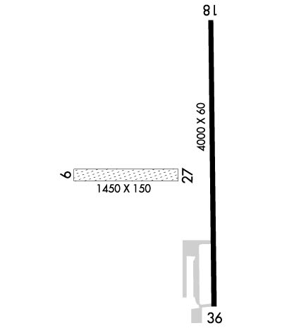
| Rwy | Rwy | |||||||
| 1450x150 | 1450' | 1450x150 | 1450' | |||||
| 4000x60 | 4000' | 4000x60 | 4000' | |||||
| Runway ID | Single Wheel | Double Wheel | Double Tandem Wheel | Dual Double Wheel |
| 09/27 | N/A | N/A | N/A | N/A |
| 18/36 | 12,500 | N/A | N/A | N/A |
| These numbers are Advisory and are not limits. The Airport Manager should have more accurate Weight Limits | ||||
 Airport Diagram might not be current. | |
| Facility Name: | JASPER COUNTY |
| City Name: | RENSSELAER |
| County: | JASPER |
| State abbrev: | IN |
| State Name: | INDIANA |
| Ownership: | PUBLICLY OWNED |
| Use: | OPEN TO THE PUBLIC |
| Owner's Name: | JASPER COUNTY AIRPORT AUTHORITY |
| Address: | 2326 W. CLARK ST. |
| RENSSELAER, IN 47978 | |
| Owner's Phone: | 219-866-2100 |
| Manager's Name: | EMILY HACKLER |
| Address: | 2326 W. CLARK ST. |
| RENSSELAER, IN 47978 | |
| Phone: | 219-866-2100; 219-869-5103. |
| FAA Region: | GREAT LAKES |
| FAA Field Office: | CHI |
| Date | Sunrise | Sunset |
|---|---|---|
| 06/08/26 Monday | 5:17 | 20:19 |
| 06/09/26 Tuesday | 5:17 | 20:19 |
| 06/10/26 Wednesday | 5:16 | 20:20 |
| 06/11/26 Thursday | 5:16 | 20:21 |
| 06/12/26 Friday | 5:16 | 20:21 |
| 06/13/26 Saturday | 5:16 | 20:21 |
| 06/14/26 Sunday | 5:16 | 20:22 |
| 06/15/26 Monday | 5:16 | 20:22 |
| 06/16/26 Tuesday | 5:16 | 20:23 |
| 06/17/26 Wednesday | 5:16 | 20:23 |
| 06/18/26 Thursday | 5:16 | 20:23 |
| 06/19/26 Friday | 5:16 | 20:24 |
| 06/20/26 Saturday | 5:17 | 20:24 |
| 06/21/26 Sunday | 5:17 | 20:24 |
| Airport Attendance Schedule | MON-FRI 0800-1700 |
| Airport Status | OPERATIONAL (This Status can change at any time - please check NOTAMS) |
| Airport Lighting Schedule | ACTVT REIL RWY 18 & 36; MIRL RWY 18/36 - CTAF. PAPI RWY 18 & 36 ON CONSLY. |
| Airport Storage Available | Tie Downs, Hanger |
| Extra Services Available | Flight Instruction, Aircraft Rental |
| Wind Indicator | YES - (lighted) |
| Control Tower | NO |
| CTAF Frequency | 122.800 |
| Unicom Frequency | 122.800 |
| Rotating Beacon Color | WG |
| Segmented Circle | NO |
| Landing Fee | NO |
| Airport Inspected | STATE - performed by STATE AERONAUTICAL PERSONNEL |
| Inspection Date | 06/09/2025 |
| Type of Fuel Available | Grade 100LL, JET A; -10SELF SVC FUEL H24 WITH CREDIT CARD. |
| Airframe Repair Service | MAJOR |
| Power Plant Repair Service | MAJOR |
| Latitude | N4056.9 |
| Longitude | W08711.0 (ESTIMATED) |
| Arpt Elevation | 698ft (SURVEYED) |
| Magnetic Variation | 02W |
| 1 miles NW | of RENSSELAER |
| Traffic Pattern Altitude | |
| Sectional Chart | CHICAGO |
| Operations (Reported) | Yearly | Avg. Daily |
|---|---|---|
| General Aviation Transient | 0 | 0 |
| General Aviation Local | 0 | 0 |
| Air Taxi | 0 | 0 |
| Commerical | 0 | 0 |
| Commuter | 0 | 0 |
| Military | 0 | 0 |
| Aircraft based on Field | |
|---|---|
| General Aviation Singles | 0 |
| General Aviation Multi | 0 |
| Jet Aircraft | 0 |
| General Aviation Helicopters | 0 |
| Military Aircraft | 0 |
| Gliders | 0 |
| Ultralights | 0 |
| FSS on field | NO |
| FSS tie-in | TERRE HAUTE |
| FSS Phone | 1-800-WX-BRIEF |
| Who issues Notams | HUF |
| Notam D service at airport | YES |
| ARTCC Name | CHICAGO |
| Airport Certification | |
| Aircraft Rescue & Firefighting Index | None |
| Airport of Entry | No |
| Custom Landing Rights | No |
| Joint Civil/Military | No |
| Military Landing rights | YES |
| NATIONAL PLAN OF INTEGRATED AIRPORT SYSTEMS (NPIAS) |
| ASSURANCES PURSUANT TO TITLE VI, CIVIL RIGHTS ACT OF 1964 |
| GRANT AGREEMENT HAS EXPIRED; HOWEVER, AGREEMENT REMAINS IN EFFECT FOR THIS FACILITY AS LONG AS IT IS PUBLIC USE. |
| COND UNMNT 1700-0800. |
| FOR CD CTC CHICAGO ARTCC AT 630-906-8921. |
Airport Communications & Frequencies:
| |||||||||
| Runway: 09 | Runway: 27 | ||
| Mag heading: | 91° | Mag heading: | 271° |
| Rwy Slope: | .37% Up | Rwy Slope: | -.37% Down |
| Approach: | Approach: | ||
| Pattern: | Left Traffic | Pattern: | Left Traffic |
| Markings: | NONE | Markings: | NONE |
| Marking Condition: | ORANGE CONES. | Marking Condition: | ORANGE CONES. |
| Arresting Dev: | Arresting Dev: | ||
| Lat & Long: | N4056.9 W08711.3 | Lat. & Long.: | N4056.9 W08711.0 |
| Elev: | 678.9 ft. MSL | Elev: | 684.2 ft. MSL |
| TCH: | TCH: | ||
| Visual Glide Path: | Visual Glide Path: | ||
| Displaced Threshold: | No | Displaced Threshold: | No |
| Touchdown Zone: | YES | Touchdown Zone: | YES |
| Touchdown Elev.: | 684.2 feet | Touchdown Elev.: | 684.4 feet |
| Visual Glide Slope: | Visual Glide Slope: | ||
| RVR Equipment: | RVR Equipment: | ||
| RVV Equipment: | NO | RVV Equipment: | NO |
| Approach Lights: | Approach Lights: | ||
| REIL: | NO | REIL: | NO |
| Centerline Lights: | NO | Centerline Lights: | NO |
| Touchdown lights: | NO | Touchdown lights: | NO |
| Runway Category: | Runway with a Visual Approach | Runway Category: | Runway with a Visual Approach |
| Declared Distances: | Declared Distances: |
| Runway: 18 | Runway: 36 | ||
| Mag heading: | 182° | Mag heading: | 2° |
| Rwy Slope: | -.60% Down | Rwy Slope: | .60% Up |
| Approach: | Approach: | ||
| Pattern: | Left Traffic | Pattern: | Left Traffic |
| Markings: | NONPRECISION INSTRUMENT | Markings: | NONPRECISION INSTRUMENT |
| Marking Condition: | FAIR | Marking Condition: | FAIR |
| Arresting Dev: | Arresting Dev: | ||
| Lat & Long: | N4057.2 W08710.9 | Lat. & Long.: | N4056.5 W08710.9 |
| Elev: | 698.2 ft. MSL | Elev: | 674.4 ft. MSL |
| TCH: | 27 ft. AGL | TCH: | 43 ft. AGL |
| Visual Glide Path: | 3.00 degrees | Visual Glide Path: | 3.00 degrees |
| Displaced Threshold: | No | Displaced Threshold: | No |
| Touchdown Zone: | YES | Touchdown Zone: | YES |
| Touchdown Elev.: | 698.2 feet | Touchdown Elev.: | 681.3 feet |
| Visual Glide Slope: | 2-Light PAPI on LEFT side of Runway | Visual Glide Slope: | 2-Light PAPI on LEFT side of Runway |
| RVR Equipment: | RVR Equipment: | ||
| RVV Equipment: | NO | RVV Equipment: | NO |
| Approach Lights: | Approach Lights: | ||
| REIL: | YES | REIL: | YES |
| Centerline Lights: | NO | Centerline Lights: | NO |
| Touchdown lights: | NO | Touchdown lights: | NO |
| Runway Category: | Runway with a Non-precision Approach | Runway Category: | Runway with a Non-precision Approach |
| Declared Distances: | Declared Distances: | ||
| Obstructions: | ROAD | Obstructions: | ROAD |
| Marked: | NOT Marked/Lighted | Marked: | NOT Marked/Lighted |
| Clearance slope: | 20:1 | Clearance slope: | 21:1 |
| Obstruction height: | 29 feet AGL | Obstruction height: | 15 feet AGL |
| Dist. from runway: | 790 feet | Dist. from runway: | 520 feet |
| Centerline offset: | Centerline offset: | ||
| Comments: | Comments: | CROPS 120 FT R OF CNTRLN AT THR; ROAD 245 FT R OF CNTRLN. TIE-DOWN AREA 100 FT FM RWY END 130 FT L OF CNTRLN. |
Thanks for using FltPlan.com
all rights reserved © 1999-2026 by Flight Plan LLC
