
| COBB COUNTY-MC COLLUM FIELD ATLANTA GA |
| |
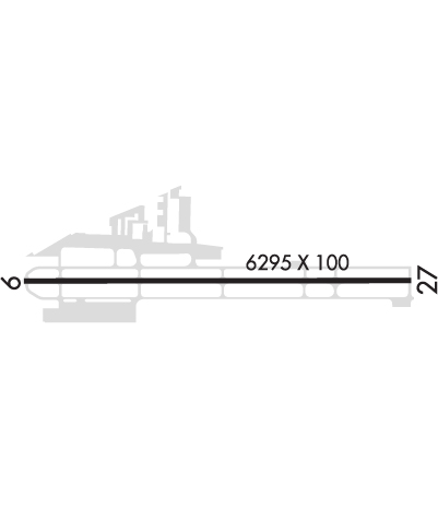
| Lat: N 3400.8 Long: W 08435.8 Elev: 1040 Var: +04 Longest Runway: 6295 | ||
| Clr Del: 119.0 Dept. ATIS: 128.12 Arr. ATIS: 128.12 Ground: 119.0 Tower: 125.9 | ||
| ||||||||||||||||||||||||||||||||||||||||||||
| ||||||||||||||||||||||||||||||||||||||||||||
| ||||||||||||||||||||||||||||||||||||||||||||
| Rwy | Rwy | |||||||
| 6295x100 | 5233' | 6295x100 | 6295' | 111.90 - 272° | ||||
| Runway ID | Single Wheel | Double Wheel | Double Tandem Wheel | Dual Double Wheel |
| 09/27 | N/A | N/A | N/A | N/A |
| These numbers are Advisory and are not limits. The Airport Manager should have more accurate Weight Limits | ||||
 Airport Diagram might not be current. | |
| Facility Name: | COBB COUNTY INTL-MCCOLLUM FLD |
| City Name: | ATLANTA |
| County: | COBB |
| State abbrev: | GA |
| State Name: | GEORGIA |
| Ownership: | PUBLICLY OWNED |
| Use: | OPEN TO THE PUBLIC |
| Owner's Name: | COBB COUNTY |
| Address: | 100 CHEROKEE STREET |
| MARIETTA, GA 30060 | |
| Owner's Phone: | 770-528-1615 |
| Manager's Name: | KARL A VON HAGEL |
| Address: | 1723 MCCOLLUM PKWY BLDG 100 |
| KENNESAW, GA 30144 | |
| Phone: | 770-528-1615 |
| FAA Region: | SOUTHERN |
| FAA Field Office: | ATL |
| Date | Sunrise | Sunset |
|---|---|---|
| 09/24/21 Friday | 7:28 | 19:33 |
| 09/25/21 Saturday | 7:28 | 19:31 |
| 09/26/21 Sunday | 7:29 | 19:30 |
| 09/27/21 Monday | 7:30 | 19:28 |
| 09/28/21 Tuesday | 7:30 | 19:27 |
| 09/29/21 Wednesday | 7:31 | 19:26 |
| 09/30/21 Thursday | 7:32 | 19:24 |
| 10/01/21 Friday | 7:33 | 19:23 |
| 10/02/21 Saturday | 7:33 | 19:22 |
| 10/03/21 Sunday | 7:34 | 19:20 |
| 10/04/21 Monday | 7:35 | 19:19 |
| 10/05/21 Tuesday | 7:36 | 19:18 |
| 10/06/21 Wednesday | 7:36 | 19:16 |
| 10/07/21 Thursday | 7:37 | 19:15 |
| Airport Attendance Schedule | 7 Days A Week 0600-0000 |
| Airport Status | OPERATIONAL (This Status can change at any time - please check NOTAMS) |
| Airport Lighting Schedule | WHEN ATCT CLSD, ACTVT MALSF RWY 27; HIRL RWY 09/27 - CTAF. |
| Airport Storage Available | Tie Downs, Hanger |
| Extra Services Available | Air Ambulance, Avionics, Charter, Flight Instruction, Aircraft Rental, Aircraft Sales |
| Wind Indicator | YES - (lighted) |
| Control Tower | YES |
| CTAF Frequency | 125.900 |
| Unicom Frequency | 122.700 |
| Rotating Beacon Color | CLEAR-GREEN (Light Land Airport) |
| Segmented Circle | YES |
| Landing Fee | NO |
| Airport Inspected | STATE - performed by STATE AERONAUTICAL PERSONNEL |
| Inspection Date | 08/24/2020 |
| Type of Fuel Available | Grade 100LL, JET A |
| Airframe Repair Service | MAJOR |
| Power Plant Repair Service | MAJOR |
| Latitude | N3400.8 |
| Longitude | W08435.8 (ESTIMATED) |
| Arpt Elevation | 1040ft (SURVEYED) |
| Magnetic Variation | 04W |
| 21 miles NW | of ATLANTA |
| Traffic Pattern Altitude | |
| Sectional Chart | ATLANTA |
| Operations (Reported) | Yearly | Avg. Daily |
|---|---|---|
| General Aviation Transient | 41487 | 114 |
| General Aviation Local | 37785 | 104 |
| Air Taxi | 2400 | 7 |
| Commerical | 0 | 0 |
| Commuter | 0 | 0 |
| Military | 823 | 2 |
| Aircraft based on Field | |
|---|---|
| General Aviation Singles | 184 |
| General Aviation Multi | 29 |
| Jet Aircraft | 49 |
| General Aviation Helicopters | 13 |
| Military Aircraft | 0 |
| Gliders | 2 |
| Ultralights | 0 |
| FSS on field | NO |
| FSS tie-in | MACON |
| FSS Phone | 1-800-WX-BRIEF |
| Who issues Notams | RYY |
| Notam D service at airport | YES |
| ARTCC Name | ATLANTA |
| Airport Certification | INDEX B AIRCRAFT RESCUE AND FIRE FIGHTING EQUIPMENT AVAILABLE UPON REQUEST. 24 HOUR PRIOR PERMISSION REQUIRED. CONTACT AIRPORT MANAGER 770-528-1615. |
| Aircraft Rescue & Firefighting Index | None |
| Airport of Entry | YES |
| Custom Landing Rights | No; US CUSTOMS USER FEE ARPT. |
| Joint Civil/Military | No |
| Military Landing rights | YES |
| NATIONAL PLAN OF INTEGRATED AIRPORT SYSTEMS (NPIAS) |
| GRANT AGREEMENTS UNDER FAAP/ADAP/AIP |
| ASSURANCES PURSUANT TO TITLE VI, CIVIL RIGHTS ACT OF 1964 |
| BLASTING SR-SS MON-FRI 2000 FT AER 27. |
| TWY B CLSD FM TWY B5 TO B6 TO ACFT WITH WINGSPANS OF 79 FT OR GTR. |
| TURBINE/JET AIRCRAFT OPERATORS ARE REQUESTED TO USE NBAA NOISE ABATEMENT PROGRAM PROCEDURES OR COMPARABLE PROCEDURES OF AIRCRAFT MANUFACTURER. |
| INT'L OPS ARPT OF ENTRY - USER FEE AIRPORT |
| ARPT MOWING IN PROGRESS SPRING THRU AUTUMN. |
| COYOTES ON & INVOF ARPT. |
| RY 9 IS CALM WIND RY IN VFR CONDS. |
| NORTH APRON AT TWY A-1 CONNECTOR IS RESTRICTED TO GROUP 1 AFCT ONLY. |
Airport Communications & Frequencies:
| |||||||||||||||||||||||||||
| Runway: 09 | Runway: 27 | ||
| Mag heading: | 93° | Mag heading: | 273° |
| Rwy Slope: | -.67% Down | Rwy Slope: | .67% Up |
| Approach: | Approach: | ILS | |
| Pattern: | Right Traffic | Pattern: | Left Traffic |
| Markings: | NONPRECISION INSTRUMENT | Markings: | PRECISION INSTRUMENT |
| Marking Condition: | GOOD | Marking Condition: | GOOD |
| Arresting Dev: | Arresting Dev: | ||
| Lat & Long: | N3400.8 W08436.4 | Lat. & Long.: | N3400.8 W08435.2 |
| Elev: | 1040.4 ft. MSL | Elev: | 998.2 ft. MSL |
| TCH: | 46 ft. AGL | TCH: | 45 ft. AGL |
| Visual Glide Path: | 4.00 degrees | Visual Glide Path: | 3.00 degrees |
| Displaced Threshold: | 1062 feet | Displaced Threshold: | No |
| Touchdown Zone: | YES | Touchdown Zone: | YES |
| Touchdown Elev.: | 1028.3 feet | Touchdown Elev.: | 1010.7 feet |
| Visual Glide Slope: | 4-Light PAPI on LEFT side of Runway | Visual Glide Slope: | 4-Light PAPI on LEFT side of Runway |
| RVR Equipment: | RVR Equipment: | ||
| RVV Equipment: | NO | RVV Equipment: | NO |
| Approach Lights: | Approach Lights: | MALSF - 1,400 foot medium intensity approach lighting system with sequenced flashers | |
| REIL: | NO | REIL: | NO |
| Centerline Lights: | NO | Centerline Lights: | NO |
| Touchdown lights: | NO | Touchdown lights: | NO |
| Runway Category: | Runway with a Non-precision Approach having visibility minimums greater than 3/4 mile | Runway Category: | Precision Instrument Runway |
| Declared Distances: | TORA:6311' TODA:6311' ASDA:6311' LDA:5233' | Declared Distances: | TORA:6311' TODA:6311' ASDA:5374' LDA:5374' |
| Obstructions: | ROAD | Obstructions: | TREES |
| Marked: | NOT Marked/Lighted | Marked: | NOT Marked/Lighted |
| Clearance slope: | 3:1; RY 09 APCH RATIO 34:1 TO DSPLCD THLD. +89FT TREES, 3,226FT 0B LEFT OR RIGHT. | Clearance slope: | 40:1 |
| Obstruction height: | 26 feet AGL | Obstruction height: | 13 feet AGL |
| Dist. from runway: | 1 feet | Dist. from runway: | 720 feet |
| Centerline offset: | Centerline offset: | 400 feet right of centerline | |
| Comments: | ROAD 0-200 FROM RUNWAY END, 380' RIGHT AND 180' LEFT. | Comments: |
Thanks for using FltPlan.com
all rights reserved © 1999-2021 by Flight Plan LLC
