
| RAY S MILLER AAF (NG) CAMP RIPLEY MN |
| |
| Lat: N 4605.4 Long: W 09421.6 Elev: 1150 Var: -03 Longest Runway: 6100 | ||
| Clr Del: 126.2 Tower: 126.2 | ||
| ||||||
|
| Rwy | Rwy | |||||||
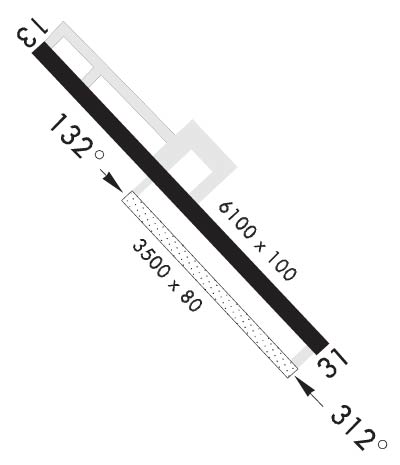
| 6100x100 | 6100' | 6100x100 | 6100' | 111.10 - 312° | ||||
| 4000x90 | 4000' | 4000x90 | 4000' | |||||
| 880x50 | 880' | 880x50 | 880' | |||||
| Runway ID | Single Wheel | Double Wheel | Double Tandem Wheel | Dual Double Wheel |
| 13/31 | N/A | N/A | N/A | N/A |
| 132/312 | N/A | N/A | N/A | N/A |
| 15/33 | N/A | N/A | N/A | N/A |
| These numbers are Advisory and are not limits. The Airport Manager should have more accurate Weight Limits | ||||
 Airport Diagram might not be current. | |
| Facility Name: | RAY S MILLER AAF |
| City Name: | CAMP RIPLEY |
| County: | MORRISON |
| State abbrev: | MN |
| State Name: | MINNESOTA |
| Ownership: | ARMY OWNED |
| Use: | PRIVATE |
| Owner's Name: | US ARMY AERONAUTICAL SVCS AGENCY |
| Address: | |
| FT BELVOIR, VA 22060 | |
| Owner's Phone: | |
| Manager's Name: | MICHAEL GUIDRY |
| Address: | |
| Phone: | 320-616-2780 |
| FAA Region: | GREAT LAKES |
| FAA Field Office: | DMA |
| Date | Sunrise | Sunset |
|---|---|---|
| 06/07/26 Sunday | 5:27 | 21:06 |
| 06/08/26 Monday | 5:27 | 21:06 |
| 06/09/26 Tuesday | 5:26 | 21:07 |
| 06/10/26 Wednesday | 5:26 | 21:08 |
| 06/11/26 Thursday | 5:26 | 21:08 |
| 06/12/26 Friday | 5:26 | 21:09 |
| 06/13/26 Saturday | 5:26 | 21:09 |
| 06/14/26 Sunday | 5:26 | 21:10 |
| 06/15/26 Monday | 5:26 | 21:10 |
| 06/16/26 Tuesday | 5:26 | 21:11 |
| 06/17/26 Wednesday | 5:26 | 21:11 |
| 06/18/26 Thursday | 5:26 | 21:11 |
| 06/19/26 Friday | 5:26 | 21:12 |
| 06/20/26 Saturday | 5:26 | 21:12 |
| Airport Attendance Schedule | MON-FRI 1300-0500Z; CLSD HOL. |
| Airport Status | OPERATIONAL (This Status can change at any time - please check NOTAMS) |
| Airport Lighting Schedule | ACTVT MALSF RWY 31; HIRL RWY 13/31 & 132/312; REIL RWY 132 & 312 - 126.2. MALSF RWY 31 & HIRL RWY 13/31 PRESET TO LOW INTST; INCR INTST - 126.2. |
| Airport Storage Available | NONE |
| Extra Services Available | NONE |
| Wind Indicator | NONE |
| Control Tower | YES |
| CTAF Frequency | |
| Unicom Frequency | |
| Rotating Beacon Color | |
| Segmented Circle | NO |
| Landing Fee |
| Airport Inspected | No Inspection Data Available performed by the OWNER |
| Inspection Date | Unknown |
| Type of Fuel Available | None |
| Airframe Repair Service | None |
| Power Plant Repair Service | None |
| Latitude | N4605.4 |
| Longitude | W09421.6 (ESTIMATED) |
| Arpt Elevation | 1149ft (ESTIMATED) |
| Magnetic Variation | 03E |
| 1 miles NW | of CAMP RIPLEY |
| Traffic Pattern Altitude | |
| Sectional Chart | TWIN CITIES |
| Operations (Reported) | Yearly | Avg. Daily |
|---|---|---|
| General Aviation Transient | 0 | 0 |
| General Aviation Local | 0 | 0 |
| Air Taxi | 0 | 0 |
| Commerical | 0 | 0 |
| Commuter | 0 | 0 |
| Military | 0 | 0 |
| Aircraft based on Field | |
|---|---|
| General Aviation Singles | 0 |
| General Aviation Multi | 0 |
| Jet Aircraft | 0 |
| General Aviation Helicopters | 0 |
| Military Aircraft | 0 |
| Gliders | 0 |
| Ultralights | 0 |
| FSS on field | NO |
| FSS tie-in | PRINCETON |
| FSS Phone | 1-800-WX-BRIEF |
| Who issues Notams | RYM |
| Notam D service at airport | YES |
| ARTCC Name | MINNEAPOLIS |
| Airport Certification | |
| Aircraft Rescue & Firefighting Index | MISC: ARFF INDEX D EQPT AVBL H24. COORD MANNING LEVEL OF SVC WITH PPR. |
| Airport of Entry | No |
| Custom Landing Rights | No |
| Joint Civil/Military | No |
| Military Landing rights | No |
| FUEL: F24 |
| RSTD: PPR - BASE OPS DSN 871-2779; C320-616-2779; TOWER C320-632-7751. |
| CAUTION: RWY EDGE LGT PSN 25 FT FM USBL RWY SFC. |
| NOISE ABATEMENT PROC IN EFCT. |
| MISC: PRK AREA CAP DESIGNED FOR 3 C130 ACFT SIMULTANEOUSLY. CTC BASE OPS FOR ASSAULT STRIP COND. |
| OPR AGENCY ARNG. |
| CAUTION: WILDLIFE HAZ. |
| CAUTION: OCNL UAS OPS - CK NOTAM. |
| MISC: PPR FOR LTD AVBL SVC ON WKEND. |
| MISC: LTD FIXED WING TSNT PRKG. |
| MISC: FOR WINTER RWY COND - C320-616-2779. |
| RSTD; RWY 15/33 FOR UNMANNED ACFT USE ONLY. |
| MISC: ARFF INDEX D EQPT AVBL H24. COORD MANNING LEVEL OF SVC WITH PPR. |
| MISC: WAIVERS: RWY 31 NO 200 FT PAVED OVRN; RWY 31 BLDGS 1600 FT APCH END; RWY 13/31 PAVED SHOULDERS 15 FT; ALL TWYS PAVED SHOULDER 0-20 FT. |
| RWY 132/ 312ASSAULT STRIP. |
Airport Communications & Frequencies:
| |||||||||||||
| Runway: 13 | Runway: 31 | ||
| Mag heading: | N/A | Mag heading: | N/A |
| Rwy Slope: | -.10% Down | Rwy Slope: | .10% Up |
| Approach: | Approach: | ILS/DME | |
| Pattern: | Left Traffic | Pattern: | Left Traffic |
| Markings: | PRECISION INSTRUMENT | Markings: | PRECISION INSTRUMENT |
| Marking Condition: | GOOD | Marking Condition: | GOOD |
| Arresting Dev: | Arresting Dev: | ||
| Lat & Long: | N4605.8 W09422.1 | Lat. & Long.: | N4605.1 W09421.1 |
| Elev: | 1149.5 ft. MSL | Elev: | 1143.4 ft. MSL |
| TCH: | TCH: | ||
| Visual Glide Path: | Visual Glide Path: | ||
| Displaced Threshold: | No | Displaced Threshold: | No |
| Touchdown Zone: | YES | Touchdown Zone: | YES |
| Touchdown Elev.: | 1149.5 feet | Touchdown Elev.: | 1146.4 feet |
| Visual Glide Slope: | Visual Glide Slope: | ||
| RVR Equipment: | RVR Equipment: | ||
| RVV Equipment: | NO | RVV Equipment: | NO |
| Approach Lights: | Approach Lights: | MALSF - 1,400 foot medium intensity approach lighting system with sequenced flashers | |
| REIL: | NO | REIL: | NO |
| Centerline Lights: | NO | Centerline Lights: | NO |
| Touchdown lights: | NO | Touchdown lights: | NO |
| Runway Category: | Runway with a Non-precision Approach having visibility minimums greater than 3/4 mile | Runway Category: | Precision Instrument Runway |
| Declared Distances: | Declared Distances: |
| Runway: 132 | Runway: 312 | ||
| Mag heading: | N/A | Mag heading: | N/A |
| Rwy Slope: | -.10% Down | Rwy Slope: | .10% Up |
| Approach: | Approach: | ||
| Pattern: | Left Traffic | Pattern: | Left Traffic |
| Markings: | Markings: | ||
| Marking Condition: | Marking Condition: | ||
| Arresting Dev: | Arresting Dev: | ||
| Lat & Long: | N4605.5 W09421.9 | Lat. & Long.: | N4605.1 W09421.2 |
| Elev: | 1149.4 ft. MSL | Elev: | 1145.6 ft. MSL |
| TCH: | TCH: | ||
| Visual Glide Path: | Visual Glide Path: | ||
| Displaced Threshold: | No | Displaced Threshold: | No |
| Touchdown Zone: | NO | Touchdown Zone: | NO |
| Touchdown Elev.: | Touchdown Elev.: | ||
| Visual Glide Slope: | Visual Glide Slope: | ||
| RVR Equipment: | RVR Equipment: | ||
| RVV Equipment: | NO | RVV Equipment: | NO |
| Approach Lights: | Approach Lights: | ||
| REIL: | YES | REIL: | YES |
| Centerline Lights: | NO | Centerline Lights: | NO |
| Touchdown lights: | NO | Touchdown lights: | NO |
| Runway Category: | Runway with a Visual Approach | Runway Category: | Runway with a Visual Approach |
| Declared Distances: | Declared Distances: |
| Runway: 15 | Runway: 33 | ||
| Mag heading: | N/A | Mag heading: | N/A |
| Rwy Slope: | -.11% Down | Rwy Slope: | .11% Up |
| Approach: | Approach: | ||
| Pattern: | Left Traffic | Pattern: | Left Traffic |
| Markings: | Markings: | ||
| Marking Condition: | Marking Condition: | ||
| Arresting Dev: | Arresting Dev: | ||
| Lat & Long: | N4605.9 W09422.0 | Lat. & Long.: | N4605.8 W09421.9 |
| Elev: | 1135.0 ft. MSL | Elev: | 1134.0 ft. MSL |
| TCH: | TCH: | ||
| Visual Glide Path: | Visual Glide Path: | ||
| Displaced Threshold: | No | Displaced Threshold: | No |
| Touchdown Zone: | YES | Touchdown Zone: | YES |
| Touchdown Elev.: | 1135.0 feet | Touchdown Elev.: | 1135.0 feet |
| Visual Glide Slope: | Visual Glide Slope: | ||
| RVR Equipment: | RVR Equipment: | ||
| RVV Equipment: | NO | RVV Equipment: | NO |
| Approach Lights: | Approach Lights: | ||
| REIL: | NO | REIL: | NO |
| Centerline Lights: | NO | Centerline Lights: | NO |
| Touchdown lights: | NO | Touchdown lights: | NO |
| Runway Category: | Runway Category: | ||
| Declared Distances: | Declared Distances: |
Thanks for using FltPlan.com
all rights reserved © 1999-2026 by Flight Plan LLC
