
| RICHARD LLOYD JONES JR TULSA OK |
| |
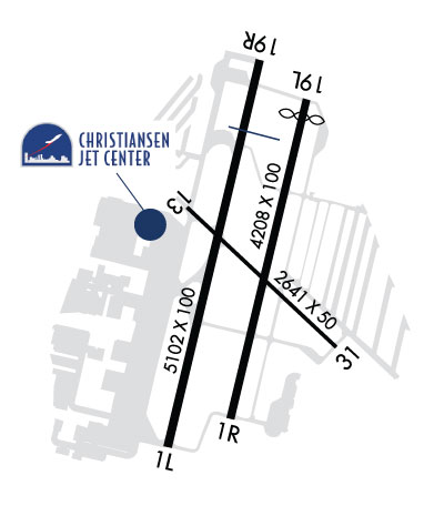
| Lat: N 3602.4 Long: W 09559.1 Elev: 638 Var: -03 Longest Runway: 5102 | ||
| Clr Del: 124.5 Dept. ATIS: 126.5 Arr. ATIS: 126.5 Ground: 121.7 Tower: 119.2/120.3 | ||
| |||||||||||||||||||||||||||||||||||||||||||||||||||||||||||||||||||||
| |||||||||||||||||||||||||||||||||||||||||||||||||||||||||||||||||||||
| |||||||||||||||||||||||||||||||||||||||||||||||||||||||||||||||||||||
| |||||||||||||||||||||||||||||||||||||||||||||||||||||||||||||||||||||
| FBOs at nearby airports who want your business: | |||||||||||||||||
| |||||||||||||||||
| Rwy | Rwy | |||||||
| 5102x100 | 5102' | 109.95 - 010° | 5102x100 | 5102' | ||||
| 4208x100 | 4208' | 4208x100 | 4066' | |||||
| 2641x50 | 2641' | 2641x50 | 2641' | |||||
| Runway ID | Single Wheel | Double Wheel | Double Tandem Wheel | Dual Double Wheel |
| 01L/19R | 61,000 | 87,000 | 168,000 | N/A |
| 01R/19L | 30,000 | 60,000 | N/A | N/A |
| 13/31 | 30,000 | N/A | N/A | N/A |
| These numbers are Advisory and are not limits. The Airport Manager should have more accurate Weight Limits | ||||
 Airport Diagram might not be current. | |
| Facility Name: | RICHARD LLOYD JONES JR |
| City Name: | TULSA |
| County: | TULSA |
| State abbrev: | OK |
| State Name: | OKLAHOMA |
| Ownership: | PUBLICLY OWNED |
| Use: | OPEN TO THE PUBLIC |
| Owner's Name: | CITY OF TULSA |
| Address: | TULSA ARPT IMPROVEMENT TRUST |
| BOX 581838 TULSA, OK 74158 | |
| Owner's Phone: | 918-838-5000 |
| Manager's Name: | AUSTIN WHEELER |
| Address: | 8303 S. HANGAR RD. |
| TULSA, OK 74132 | |
| Phone: | 918-299-5886 |
| FAA Region: | SOUTHWEST |
| FAA Field Office: | AOK |
| Date | Sunrise | Sunset |
|---|---|---|
| 09/24/21 Friday | 7:13 | 19:18 |
| 09/25/21 Saturday | 7:14 | 19:17 |
| 09/26/21 Sunday | 7:15 | 19:15 |
| 09/27/21 Monday | 7:16 | 19:14 |
| 09/28/21 Tuesday | 7:16 | 19:12 |
| 09/29/21 Wednesday | 7:17 | 19:11 |
| 09/30/21 Thursday | 7:18 | 19:09 |
| 10/01/21 Friday | 7:19 | 19:08 |
| 10/02/21 Saturday | 7:20 | 19:06 |
| 10/03/21 Sunday | 7:20 | 19:05 |
| 10/04/21 Monday | 7:21 | 19:04 |
| 10/05/21 Tuesday | 7:22 | 19:02 |
| 10/06/21 Wednesday | 7:23 | 19:01 |
| 10/07/21 Thursday | 7:24 | 18:59 |
| Airport Attendance Schedule | 7 Days A Week 0600 - 2200; AFT HRS BY PRIOR ARRANGMENT. |
| Airport Status | OPERATIONAL (This Status can change at any time - please check NOTAMS) |
| Airport Lighting Schedule | WHEN ATCT CLSD HIRL RY 01L/19R PRESET MED INTST; TO INCR INTST ACTVT-120.3. WHEN ATCT CLSD ACTVT MIRL RYS 13/31 & 01R/19L, TWYS H, L, T, & Z, TAXILANE DD LGTS-120.3 |
| Airport Storage Available | Tie Downs, Hanger |
| Extra Services Available | Air Ambulance, Avionics, Charter, Flight Instruction, Aircraft Rental, Aircraft Sales |
| Wind Indicator | YES - (lighted) |
| Control Tower | YES |
| CTAF Frequency | 120.300 |
| Unicom Frequency | 122.950 |
| Rotating Beacon Color | CLEAR-GREEN (Light Land Airport) |
| Segmented Circle | YES |
| Landing Fee | NO |
| Airport Inspected | STATE - performed by STATE AERONAUTICAL PERSONNEL |
| Inspection Date | 10/10/2018 |
| Type of Fuel Available | Grade 100LL, JET A (freeze point -40C) |
| Airframe Repair Service | MAJOR |
| Power Plant Repair Service | MAJOR |
| Latitude | N3602.4 |
| Longitude | W09559.1 (ESTIMATED) |
| Arpt Elevation | 637ft (SURVEYED) |
| Magnetic Variation | 03E |
| 5 miles S | of TULSA |
| Traffic Pattern Altitude | |
| Sectional Chart | KANSAS CITY |
| Operations (Reported) | Yearly | Avg. Daily |
|---|---|---|
| General Aviation Transient | 73122 | 200 |
| General Aviation Local | 117960 | 323 |
| Air Taxi | 2680 | 7 |
| Commerical | 25 | 0 |
| Commuter | 0 | 0 |
| Military | 1304 | 4 |
| Aircraft based on Field | |
|---|---|
| General Aviation Singles | 257 |
| General Aviation Multi | 31 |
| Jet Aircraft | 14 |
| General Aviation Helicopters | 7 |
| Military Aircraft | 0 |
| Gliders | 4 |
| Ultralights | 0 |
| FSS on field | NO |
| FSS tie-in | MC ALESTER |
| FSS Phone | 1-800-WX-BRIEF |
| Who issues Notams | RVS |
| Notam D service at airport | YES |
| ARTCC Name | KANSAS CITY |
| Airport Certification | |
| Aircraft Rescue & Firefighting Index | None |
| Airport of Entry | No |
| Custom Landing Rights | No |
| Joint Civil/Military | No |
| Military Landing rights | YES |
| NATIONAL PLAN OF INTEGRATED AIRPORT SYSTEMS (NPIAS) |
| GRANT AGREEMENTS UNDER FAAP/ADAP/AIP |
| ASSURANCES PURSUANT TO TITLE VI, CIVIL RIGHTS ACT OF 1964 |
| THE NE, NW & SW RAMPS AND PORTIONS OF TAXILANES CC, DD, & GG ARE NOT VISIBLE FM ATCT. |
| NOISE ABATEMENT: NO TURNS ON DEPARTURE PRIOR TO 1500' MSL. |
| NUMEROUS BIRDS ON & INVOF ARPT. |
| TAXILANE BB & NW PRIVATE HANGAR AREA TAXILANES 20 FT WIDE. |
| RY 13 NO LEFT TURNS ON DEP PRIOR TO 1,500 FT MSL. |
| RY 31 MNTN TPA UNTIL ABEAM AER ON DOWNWIND LEG. |
| MAX 49 FT WINGSPAN IN NE AND NW PRIVATE HANGAR AREAS. |
| NE AND NW PRIVATE HANGAR AREA TAXILANES WEIGHT LIMIT 12500 POUNDS. |
| RWY 01L/ 19RRWY 01L/19R CNTR 80 FT GRVD; RWY 01/19R EDGES EACH SIDE 10 FT NOT GRVD |
Airport Communications & Frequencies:
| |||||||||||||||||||||||||||||||
| Runway: 01L | Runway: 19R | ||
| Mag heading: | 10° | Mag heading: | 190° |
| Rwy Slope: | .32% Up | Rwy Slope: | -.32% Down |
| Approach: | ILS | Approach: | |
| Pattern: | Left Traffic | Pattern: | Right Traffic |
| Markings: | PRECISION INSTRUMENT | Markings: | NONPRECISION INSTRUMENT |
| Marking Condition: | GOOD | Marking Condition: | GOOD |
| Arresting Dev: | Arresting Dev: | ||
| Lat & Long: | N3602.0 W09559.3 | Lat. & Long.: | N3602.8 W09559.0 |
| Elev: | 621.5 ft. MSL | Elev: | 637.9 ft. MSL |
| TCH: | 48 ft. AGL | TCH: | 43 ft. AGL |
| Visual Glide Path: | 3.00 degrees | Visual Glide Path: | 3.20 degrees |
| Displaced Threshold: | No | Displaced Threshold: | No |
| Touchdown Zone: | YES | Touchdown Zone: | YES |
| Touchdown Elev.: | 625.8 feet | Touchdown Elev.: | 637.9 feet |
| Visual Glide Slope: | 4-Light PAPI on LEFT side of Runway | Visual Glide Slope: | 4-Light PAPI on LEFT side of Runway |
| RVR Equipment: | RVR Equipment: | ||
| RVV Equipment: | NO | RVV Equipment: | NO |
| Approach Lights: | Approach Lights: | ||
| REIL: | YES | REIL: | YES |
| Centerline Lights: | NO | Centerline Lights: | NO |
| Touchdown lights: | NO | Touchdown lights: | NO |
| Runway Category: | Precision Instrument Runway | Runway Category: | Runway with a Non-precision Approach having visibility minimums greater than 3/4 mile |
| Declared Distances: | TORA:5102' TODA:5102' ASDA:5102' LDA:5102' | Declared Distances: | TORA:5102' TODA:5102' ASDA:5102' LDA:5102' |
| Obstructions: | ROAD | Obstructions: | TREES |
| Marked: | NOT Marked/Lighted | Marked: | NOT Marked/Lighted |
| Clearance slope: | 47:1 | Clearance slope: | 30:1 |
| Obstruction height: | 13 feet AGL | Obstruction height: | 28 feet AGL |
| Dist. from runway: | 820 feet | Dist. from runway: | 1060 feet |
| Centerline offset: | Centerline offset: | 100 feet left of centerline | |
| Comments: | Comments: |
| Runway: 01R | Runway: 19L | ||
| Mag heading: | 10° | Mag heading: | 190° |
| Rwy Slope: | .26% Up | Rwy Slope: | -.26% Down |
| Approach: | Approach: | ||
| Pattern: | Right Traffic | Pattern: | Left Traffic |
| Markings: | BASIC | Markings: | BASIC |
| Marking Condition: | FAIR | Marking Condition: | FAIR |
| Arresting Dev: | Arresting Dev: | ||
| Lat & Long: | N3602.0 W09559.1 | Lat. & Long.: | N3602.7 W09558.9 |
| Elev: | 619.0 ft. MSL | Elev: | 630.0 ft. MSL |
| TCH: | 40 ft. AGL | TCH: | 40 ft. AGL |
| Visual Glide Path: | 2.83 degrees | Visual Glide Path: | 2.83 degrees |
| Displaced Threshold: | No | Displaced Threshold: | 142 feet |
| Touchdown Zone: | YES | Touchdown Zone: | YES |
| Touchdown Elev.: | 623.7 feet | Touchdown Elev.: | 630.0 feet |
| Visual Glide Slope: | 4-Light PAPI on LEFT side of Runway | Visual Glide Slope: | 4-Light PAPI on LEFT side of Runway |
| RVR Equipment: | RVR Equipment: | ||
| RVV Equipment: | NO | RVV Equipment: | NO |
| Approach Lights: | Approach Lights: | ||
| REIL: | NO | REIL: | NO |
| Centerline Lights: | NO | Centerline Lights: | NO |
| Touchdown lights: | NO | Touchdown lights: | NO |
| Runway Category: | Runway with a Visual Approach | Runway Category: | Runway with a Visual Approach |
| Declared Distances: | TORA:4208' TODA:4208' ASDA:4208' LDA:4208' | Declared Distances: | TORA:4208' TODA:4208' ASDA:4208' LDA:4066' |
| Obstructions: | TREES | Obstructions: | ROAD |
| Marked: | NOT Marked/Lighted | Marked: | NOT Marked/Lighted |
| Clearance slope: | 13:1 | Clearance slope: | |
| Obstruction height: | 45 feet AGL | Obstruction height: | 8 feet AGL |
| Dist. from runway: | 808 feet | Dist. from runway: | 200 feet |
| Centerline offset: | 295 right of centerline | Centerline offset: | |
| Comments: | Comments: |
| Runway: 13 | Runway: 31 | ||
| Mag heading: | 130° | Mag heading: | 310° |
| Rwy Slope: | -.35% Down | Rwy Slope: | .35% Up |
| Approach: | Approach: | ||
| Pattern: | Left Traffic | Pattern: | Right Traffic |
| Markings: | BASIC | Markings: | BASIC |
| Marking Condition: | GOOD | Marking Condition: | FAIR |
| Arresting Dev: | Arresting Dev: | ||
| Lat & Long: | N3602.5 W09559.2 | Lat. & Long.: | N3602.2 W09558.8 |
| Elev: | 623.8 ft. MSL | Elev: | 614.6 ft. MSL |
| TCH: | TCH: | ||
| Visual Glide Path: | Visual Glide Path: | ||
| Displaced Threshold: | No | Displaced Threshold: | No |
| Touchdown Zone: | YES | Touchdown Zone: | YES |
| Touchdown Elev.: | 625.8 feet | Touchdown Elev.: | 625.8 feet |
| Visual Glide Slope: | Visual Glide Slope: | ||
| RVR Equipment: | RVR Equipment: | ||
| RVV Equipment: | NO | RVV Equipment: | NO |
| Approach Lights: | Approach Lights: | ||
| REIL: | NO | REIL: | NO |
| Centerline Lights: | NO | Centerline Lights: | NO |
| Touchdown lights: | NO | Touchdown lights: | NO |
| Runway Category: | Runway with a Visual Approach | Runway Category: | Runway with a Visual Approach |
| Declared Distances: | TORA:2641' TODA:2641' ASDA:2641' LDA:2641' | Declared Distances: | TORA:2641' TODA:2641' ASDA:2641' LDA:2641' |
Thanks for using FltPlan.com
all rights reserved © 1999-2021 by Flight Plan LLC