
| SWINTON SMITH FLD REIDSVILLE GA |
| |
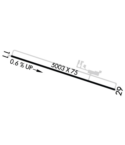
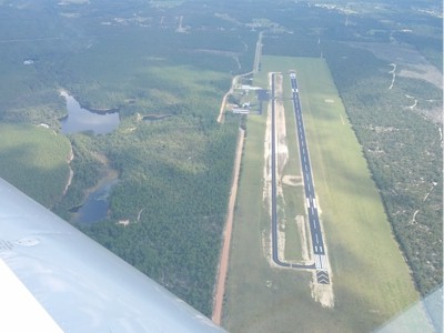
| Lat: N 3203.6 Long: W 08209.2 Elev: 196 Var: +06 Longest Runway: 5003 | ||
| CTAF: 122.9 | ||
| ||||||||||||||||||||||||
| ||||||||||||||||||||||||
| Rwy | Rwy | |||||||
| 5003x75 | 5003' | 5003x75 | 5003' | |||||
| Runway ID | Single Wheel | Double Wheel | Double Tandem Wheel | Dual Double Wheel |
| 11/29 | 30,000 | N/A | N/A | N/A |
| These numbers are Advisory and are not limits. The Airport Manager should have more accurate Weight Limits | ||||
 Airport Diagram might not be current. | |
| Facility Name: | SWINTON SMITH FLD AT REIDSVILLE MUNI |
| City Name: | REIDSVILLE |
| County: | TATTNALL |
| State abbrev: | GA |
| State Name: | GEORGIA |
| Ownership: | PUBLICLY OWNED |
| Use: | OPEN TO THE PUBLIC |
| Owner's Name: | CITY OF REIDSVILLE |
| Address: | PO BOX 730 |
| REIDSVILLE, GA 30453 | |
| Owner's Phone: | 912-557-4786 |
| Manager's Name: | WIL SMITH; CHAIR OF AIRPORT AUTHORITY |
| Address: | BOX 2351 |
| REIDSVILLE, GA 30453 | |
| Phone: | (912) 246-2500 |
| FAA Region: | SOUTHERN |
| FAA Field Office: | ATL |
| Date | Sunrise | Sunset |
|---|---|---|
| 09/24/21 Friday | 7:18 | 19:23 |
| 09/25/21 Saturday | 7:19 | 19:22 |
| 09/26/21 Sunday | 7:19 | 19:20 |
| 09/27/21 Monday | 7:20 | 19:19 |
| 09/28/21 Tuesday | 7:20 | 19:18 |
| 09/29/21 Wednesday | 7:21 | 19:16 |
| 09/30/21 Thursday | 7:22 | 19:15 |
| 10/01/21 Friday | 7:22 | 19:14 |
| 10/02/21 Saturday | 7:23 | 19:12 |
| 10/03/21 Sunday | 7:24 | 19:11 |
| 10/04/21 Monday | 7:24 | 19:10 |
| 10/05/21 Tuesday | 7:25 | 19:09 |
| 10/06/21 Wednesday | 7:26 | 19:07 |
| 10/07/21 Thursday | 7:26 | 19:06 |
| Airport Attendance Schedule | UNATTENDED |
| Airport Status | OPERATIONAL (This Status can change at any time - please check NOTAMS) |
| Airport Lighting Schedule | ACTVT PAPI RYS 11 & 29, MIRL RY 11/29 PRESET LOW INTS DUSK-0230; TO INCR INTS & ACTVT AFTER 0230 - CTAF. |
| Airport Storage Available | Tie Downs |
| Extra Services Available | Flight Instruction, Aircraft Rental |
| Wind Indicator | YES - (lighted) |
| Control Tower | NO |
| CTAF Frequency | 122.900 |
| Unicom Frequency | |
| Rotating Beacon Color | CLEAR-GREEN (Light Land Airport) |
| Segmented Circle | YES |
| Landing Fee | NO |
| Airport Inspected | STATE - performed by STATE AERONAUTICAL PERSONNEL |
| Inspection Date | 02/19/2020 |
| Type of Fuel Available | Grade 100LL, JET A (freeze point -40C); -10FUEL 24 HR CREDIT CARD SVC AVBL. |
| Airframe Repair Service | NONE |
| Power Plant Repair Service | NONE |
| Latitude | N3203.6 |
| Longitude | W08209.2 (ESTIMATED) |
| Arpt Elevation | 195ft (SURVEYED) |
| Magnetic Variation | 06W |
| 3 miles SW | of REIDSVILLE |
| Traffic Pattern Altitude | |
| Sectional Chart | ATLANTA |
| Operations (Reported) | Yearly | Avg. Daily |
|---|---|---|
| General Aviation Transient | 2500 | 7 |
| General Aviation Local | 2500 | 7 |
| Air Taxi | 0 | 0 |
| Commerical | 0 | 0 |
| Commuter | 0 | 0 |
| Military | 500 | 1 |
| Aircraft based on Field | |
|---|---|
| General Aviation Singles | 8 |
| General Aviation Multi | 2 |
| Jet Aircraft | 0 |
| General Aviation Helicopters | 1 |
| Military Aircraft | 0 |
| Gliders | 0 |
| Ultralights | 0 |
| FSS on field | NO |
| FSS tie-in | MACON |
| FSS Phone | 1-800-WX-BRIEF |
| Who issues Notams | MCN |
| Notam D service at airport | YES |
| ARTCC Name | JACKSONVILLE |
| Airport Certification | |
| Aircraft Rescue & Firefighting Index | None |
| Airport of Entry | No |
| Custom Landing Rights | No |
| Joint Civil/Military | No |
| Military Landing rights | YES |
| NATIONAL PLAN OF INTEGRATED AIRPORT SYSTEMS (NPIAS) |
| GRANT AGREEMENTS UNDER FAAP/ADAP/AIP |
| ASSURANCES PURSUANT TO TITLE VI, CIVIL RIGHTS ACT OF 1964 |
| FOR CD CTC JACKSONVILLE ARTCC AT 904-845-1592. |
Airport Communications & Frequencies:
| |||||||
| Runway: 11 | Runway: 29 | ||
| Mag heading: | 114° | Mag heading: | 294° |
| Rwy Slope: | .63% Up | Rwy Slope: | -.63% Down |
| Approach: | Approach: | ||
| Pattern: | Left Traffic | Pattern: | Left Traffic |
| Markings: | NONPRECISION INSTRUMENT | Markings: | NONPRECISION INSTRUMENT |
| Marking Condition: | GOOD | Marking Condition: | GOOD |
| Arresting Dev: | Arresting Dev: | ||
| Lat & Long: | N3203.7 W08209.7 | Lat. & Long.: | N3203.4 W08208.8 |
| Elev: | 164.0 ft. MSL | Elev: | 195.4 ft. MSL |
| TCH: | 40 ft. AGL | TCH: | 31 ft. AGL |
| Visual Glide Path: | 3.00 degrees | Visual Glide Path: | 3.00 degrees |
| Displaced Threshold: | No | Displaced Threshold: | No |
| Touchdown Zone: | YES | Touchdown Zone: | YES |
| Touchdown Elev.: | 183.9 feet | Touchdown Elev.: | 195.6 feet |
| Visual Glide Slope: | 2-Light PAPI on LEFT side of Runway | Visual Glide Slope: | 2-Light PAPI on LEFT side of Runway |
| RVR Equipment: | RVR Equipment: | ||
| RVV Equipment: | NO | RVV Equipment: | NO |
| Approach Lights: | Approach Lights: | ||
| REIL: | NO | REIL: | NO |
| Centerline Lights: | NO | Centerline Lights: | NO |
| Touchdown lights: | NO | Touchdown lights: | NO |
| Runway Category: | Runway with a Non-precision Approach having visibility minimums greater than 3/4 mile | Runway Category: | Runway with a Visual Approach |
| Declared Distances: | Declared Distances: |
Thanks for using FltPlan.com
all rights reserved © 1999-2021 by Flight Plan LLC

