
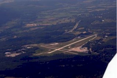
| RUTLAND - SOUTHERN VERMONT RGN RUTLAND VT |
| |
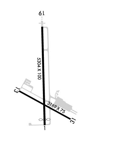
| Lat: N 4331.8 Long: W 07257.0 Elev: 787 Var: +15 Longest Runway: 5304 | ||
| Clr Del: 135.7 AWOS: 118.37 CTAF: 122.8 | ||
| ||||||||||||||||||||||||||||||||||||||||||||
| ||||||||||||||||||||||||||||||||||||||||||||
| ||||||||||||||||||||||||||||||||||||||||||||
| Rwy | Rwy | |||||||
| 5304x100 | 5004' | 5304x100 | 5304' | 111.70 - 193° | ||||
| 3169x75 | 3169' | 3169x75 | 3169' | |||||
| Runway ID | Single Wheel | Double Wheel | Double Tandem Wheel | Dual Double Wheel |
| 01/19 | 40,000 | 68,000 | N/A | N/A |
| 13/31 | 30,000 | N/A | N/A | N/A |
| These numbers are Advisory and are not limits. The Airport Manager should have more accurate Weight Limits | ||||
 Airport Diagram might not be current. | |
| Facility Name: | RUTLAND/SOUTHERN VERMONT RGNL |
| City Name: | RUTLAND |
| County: | RUTLAND |
| State abbrev: | VT |
| State Name: | VERMONT |
| Ownership: | PUBLICLY OWNED |
| Use: | OPEN TO THE PUBLIC |
| Owner's Name: | STATE OF VERMONT |
| Address: | 219 N MAIN ST |
| BARRE, VT 05641 | |
| Owner's Phone: | 802-272-7725 |
| Manager's Name: | CHRISTOPHER BEITZEL |
| Address: | 219 N MAIN ST |
| BARRE, VT 05641 | |
| Phone: | 802-272-7725 |
| FAA Region: | NEW ENGLAND |
| FAA Field Office: | NONE |
| Date | Sunrise | Sunset |
|---|---|---|
| 06/08/26 Monday | 5:11 | 20:31 |
| 06/09/26 Tuesday | 5:11 | 20:31 |
| 06/10/26 Wednesday | 5:11 | 20:32 |
| 06/11/26 Thursday | 5:10 | 20:33 |
| 06/12/26 Friday | 5:10 | 20:33 |
| 06/13/26 Saturday | 5:10 | 20:34 |
| 06/14/26 Sunday | 5:10 | 20:34 |
| 06/15/26 Monday | 5:10 | 20:35 |
| 06/16/26 Tuesday | 5:10 | 20:35 |
| 06/17/26 Wednesday | 5:10 | 20:35 |
| 06/18/26 Thursday | 5:10 | 20:36 |
| 06/19/26 Friday | 5:10 | 20:36 |
| 06/20/26 Saturday | 5:10 | 20:36 |
| 06/21/26 Sunday | 5:11 | 20:36 |
| Airport Attendance Schedule | 7 Days A Week 0700-1930; FOR AFT HRS SVC CALL 802-773-3348. |
| Airport Status | OPERATIONAL (This Status can change at any time - please check NOTAMS) |
| Airport Lighting Schedule | ACTVT MALSR RWY 19; REIL RWY 13; HIRL RWY 01/19; MIRL RWY 13/31 - CTAF. |
| Airport Storage Available | Tie Downs, Hanger |
| Extra Services Available | Air Freight, Charter, Flight Instruction, Aircraft Rental, Aircraft Sales |
| Wind Indicator | YES - (lighted) |
| Control Tower | NO |
| CTAF Frequency | 122.800 |
| Unicom Frequency | 122.800 |
| Rotating Beacon Color | WG |
| Segmented Circle | YES |
| Landing Fee | YES; LDG FEES MAY APPLY FOR COML ACFT. |
| Airport Inspected | STATE - performed by FAA AIRPORTS FIELD PERSONNEL |
| Inspection Date | 11/21/2025 |
| Type of Fuel Available | Grade 100LL, JET A (freeze point -40C) |
| Airframe Repair Service | MAJOR |
| Power Plant Repair Service | MAJOR |
| Latitude | N4331.8 |
| Longitude | W07257.0 (ESTIMATED) |
| Arpt Elevation | 787ft (SURVEYED) |
| Magnetic Variation | 15W |
| 5 miles S | of RUTLAND |
| Traffic Pattern Altitude | |
| Sectional Chart | NEW YORK |
| Operations (Reported) | Yearly | Avg. Daily |
|---|---|---|
| General Aviation Transient | 0 | 0 |
| General Aviation Local | 0 | 0 |
| Air Taxi | 0 | 0 |
| Commerical | 0 | 0 |
| Commuter | 0 | 0 |
| Military | 0 | 0 |
| Aircraft based on Field | |
|---|---|
| General Aviation Singles | 0 |
| General Aviation Multi | 0 |
| Jet Aircraft | 0 |
| General Aviation Helicopters | 0 |
| Military Aircraft | 0 |
| Gliders | 0 |
| Ultralights | 0 |
| FSS on field | NO |
| FSS tie-in | BURLINGTON |
| FSS Phone | 1-800-WX-BRIEF |
| Who issues Notams | RUT |
| Notam D service at airport | YES |
| ARTCC Name | BOSTON |
| Airport Certification | ARFF SVC AVBL FOR NON-AIR CARRIER OPS, 48 HR PPR. CTC AMGR. |
| Aircraft Rescue & Firefighting Index | AIRPORT HAS A CERTIFICATE UNDER CFR PART 139 |
| Airport of Entry | No |
| Custom Landing Rights | No |
| Joint Civil/Military | No |
| Military Landing rights | YES |
| NATIONAL PLAN OF INTEGRATED AIRPORT SYSTEMS (NPIAS) |
| GRANT AGREEMENTS UNDER FAAP/ADAP/AIP |
| ASSURANCES PURSUANT TO TITLE VI, CIVIL RIGHTS ACT OF 1964 |
| AGREEMENT UNDER DLAND OR DCLA HAS EXPIRED. |
| ACFT WITH WING SPANS EXCEEDING 79 FT AUZD TO USE TWY H & TWY B EAST OF RWY 1/19 & RWY 13/31 FOR TAX & RWYS 01 & 19 FOR TKOF & LDG. NOISE SENSITIVE AREA SE OF ARPT CTC AMGR. |
| FOR CD CTC BOSTON ARTCC AT 603-879-6859. |
| RWY CONDS MAY NOT BE MNT OR RPRTD WHEN ARPT IS UNATNDD. |
| TYPE I & TYPE IV DEICING AVBL. |
| BIRDS ON & INVOF ARPT. |
| COLD TEMPERATURE AIRPORT. ALTITUDE CORRECTION REQUIRED AT OR BELOW -7C. |
| USE TWY A TO TAX TO OR FM AER 01 OR 19. |
| TWY C CNCTS MAIN APRON WITH TWY A. |
| RWY 01/1 9 RWY 01/19 NOT AVBL FOR PART 121/PART 380 OPS WITH SKED PAX CARRYING OPS MORE THAN 9 PAX SEATS AND NON-SKED PAX CARRYING OPS MORE THAN 30 PAX SEATS. 90 DAY PPR FOR UNSKED ACR OPS GTR THAN 30 PAX SEATS - CALL AMGR. |
| RWY 13/3 1 RWY 13/31 NOT AVBL FOR PART 121/PART 380 OPS WITH SKED PAX CARRYING OPS MORE THAN 9 PAX SEATS AND NON-SKED PAX CARRYING OPS MORE THAN 30 PAX SEATS. 90 DAY PPR FOR UNSKED ACR OPS GTR THAN 30 PAX SEATS - CALL AMGR. |
| RWY 01/1 9 PCR VALUE: 271/F/D/X/T |
| RWY 13/3 1 PCR VALUE: 172/F/D/X/T |
Airport Communications & Frequencies:
| |||||||||
| Runway: 01 | Runway: 19 | ||
| Mag heading: | 14° | Mag heading: | 194° |
| Rwy Slope: | -.14% Down | Rwy Slope: | .14% Up |
| Approach: | Approach: | ILS/DME | |
| Pattern: | Left Traffic | Pattern: | Right Traffic |
| Markings: | NONPRECISION INSTRUMENT | Markings: | PRECISION INSTRUMENT |
| Marking Condition: | GOOD | Marking Condition: | GOOD |
| Arresting Dev: | Arresting Dev: | ||
| Lat & Long: | N4331.4 W07257.0 | Lat. & Long.: | N4332.3 W07257.0 |
| Elev: | 781.3 ft. MSL | Elev: | 774.0 ft. MSL |
| TCH: | 17 ft. AGL | TCH: | 55 ft. AGL |
| Visual Glide Path: | 3.50 degrees | Visual Glide Path: | 3.20 degrees |
| Displaced Threshold: | 300 feet | Displaced Threshold: | No |
| Touchdown Zone: | YES | Touchdown Zone: | YES |
| Touchdown Elev.: | 787.3 feet | Touchdown Elev.: | 787.3 feet |
| Visual Glide Slope: | PULSATING/STEADY BURNING VASI ON RIGHT SIDE OF RUNWAY; OTS UFN. | Visual Glide Slope: | 4-Light PAPI on LEFT side of Runway |
| RVR Equipment: | RVR Equipment: | ||
| RVV Equipment: | NO | RVV Equipment: | NO |
| Approach Lights: | Approach Lights: | MALSR - 1,400 foot medium intensity approach lighting system with runway alignment indicator lights | |
| REIL: | NO | REIL: | NO |
| Centerline Lights: | NO | Centerline Lights: | NO |
| Touchdown lights: | NO | Touchdown lights: | NO |
| Runway Category: | Runway with a Non-precision Approach having visibility minimums greater than 3/4 mile | Runway Category: | Precision Instrument Runway |
| Declared Distances: | TORA:5304' TODA:5304' ASDA:5304' LDA:5004' | Declared Distances: | TORA:5004' TODA:5004' ASDA:5004' LDA:5004' |
| Obstructions: | HILL | Obstructions: | |
| Marked: | NOT Marked/Lighted | Marked: | |
| Clearance slope: | 34:1 | Clearance slope: | 50:1 |
| Obstruction height: | 135 feet AGL | Obstruction height: | |
| Dist. from runway: | 4800 feet | Dist. from runway: | |
| Centerline offset: | B | Centerline offset: | |
| Comments: | Comments: |
| Runway: 13 | Runway: 31 | ||
| Mag heading: | 134° | Mag heading: | 314° |
| Rwy Slope: | .00% Down | Rwy Slope: | .00% Up |
| Approach: | Approach: | ||
| Pattern: | Left Traffic | Pattern: | Left Traffic |
| Markings: | BASIC | Markings: | BASIC |
| Marking Condition: | GOOD | Marking Condition: | GOOD |
| Arresting Dev: | Arresting Dev: | ||
| Lat & Long: | N4331.7 W07257.3 | Lat. & Long.: | N4331.5 W07256.7 |
| Elev: | 782.3 ft. MSL | Elev: | 782.2 ft. MSL |
| TCH: | TCH: | ||
| Visual Glide Path: | Visual Glide Path: | ||
| Displaced Threshold: | No | Displaced Threshold: | No |
| Touchdown Zone: | YES | Touchdown Zone: | YES |
| Touchdown Elev.: | 784.5 feet | Touchdown Elev.: | 784.5 feet |
| Visual Glide Slope: | Visual Glide Slope: | ||
| RVR Equipment: | RVR Equipment: | ||
| RVV Equipment: | NO | RVV Equipment: | NO |
| Approach Lights: | Approach Lights: | ||
| REIL: | YES | REIL: | NO |
| Centerline Lights: | NO | Centerline Lights: | NO |
| Touchdown lights: | NO | Touchdown lights: | NO |
| Runway Category: | Runway with a Visual Approach | Runway Category: | Runway with a Visual Approach |
| Declared Distances: | Declared Distances: | ||
| Obstructions: | ROAD | Obstructions: | TREES |
| Marked: | NOT Marked/Lighted | Marked: | NOT Marked/Lighted |
| Clearance slope: | 7:1 | Clearance slope: | 20:1 |
| Obstruction height: | 16 feet AGL | Obstruction height: | 20 feet AGL |
| Dist. from runway: | 325 feet | Dist. from runway: | 600 feet |
| Centerline offset: | Centerline offset: | 100 feet right of centerline | |
| Comments: | Comments: |
Thanks for using FltPlan.com
all rights reserved © 1999-2026 by Flight Plan LLC