
| CRAWFORD COUNTY ROBINSON IL |
| |
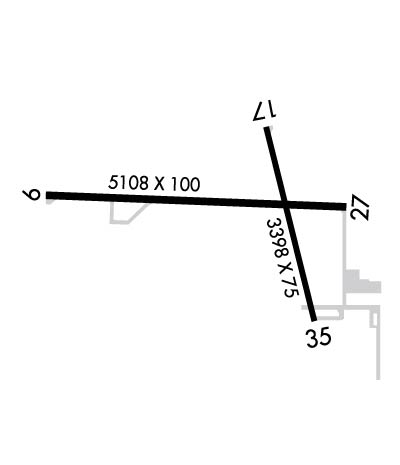
| Lat: N 3901.0 Long: W 08739.0 Elev: 461 Var: +03 Longest Runway: 5108 | ||
| AWOS: 120.5 CTAF: 123.0 | ||
| ||||||||||||||||||||||||||||||||||||||||||||
| ||||||||||||||||||||||||||||||||||||||||||||
| ||||||||||||||||||||||||||||||||||||||||||||
| Rwy | Rwy | |||||||
| 5108x100 | 5108' | 5108x100 | 5108' | |||||
| 3398x75 | 3398' | 3398x75 | 3398' | |||||
| Runway ID | Single Wheel | Double Wheel | Double Tandem Wheel | Dual Double Wheel |
| 09/27 | 35,000 | 50,000 | 65,000 | N/A |
| 17/35 | 5,000 | N/A | N/A | N/A |
| These numbers are Advisory and are not limits. The Airport Manager should have more accurate Weight Limits | ||||
 Airport Diagram might not be current. | |
| Facility Name: | CRAWFORD COUNTY |
| City Name: | ROBINSON |
| County: | CRAWFORD |
| State abbrev: | IL |
| State Name: | ILLINOIS |
| Ownership: | PUBLICLY OWNED |
| Use: | OPEN TO THE PUBLIC |
| Owner's Name: | CRAWFORD COUNTY ARPT AUTHORITY |
| Address: | 10748 NORTH 1650 ST |
| PALESTINE, IL 62451 | |
| Owner's Phone: | 618-586-2121 |
| Manager's Name: | HOWARD HUNT & SANDY STASZAK |
| Address: | 10748 NORTH 1650 ST |
| PALESTINE, IL 62451 | |
| Phone: | 618-586-2121 |
| FAA Region: | GREAT LAKES |
| FAA Field Office: | CHI |
| Date | Sunrise | Sunset |
|---|---|---|
| 05/07/24 Tuesday | 5:45 | 19:50 |
| 05/08/24 Wednesday | 5:44 | 19:51 |
| 05/09/24 Thursday | 5:43 | 19:52 |
| 05/10/24 Friday | 5:42 | 19:53 |
| 05/11/24 Saturday | 5:41 | 19:54 |
| 05/12/24 Sunday | 5:40 | 19:55 |
| 05/13/24 Monday | 5:39 | 19:55 |
| 05/14/24 Tuesday | 5:38 | 19:56 |
| 05/15/24 Wednesday | 5:37 | 19:57 |
| 05/16/24 Thursday | 5:36 | 19:58 |
| 05/17/24 Friday | 5:35 | 19:59 |
| 05/18/24 Saturday | 5:35 | 20:00 |
| 05/19/24 Sunday | 5:34 | 20:01 |
| 05/20/24 Monday | 5:33 | 20:02 |
| Airport Attendance Schedule | MON-SAT 0700-1800 |
| Airport Status | OPERATIONAL (This Status can change at any time - please check NOTAMS) |
| Airport Lighting Schedule | MIRL RY 09/27 PRESET ON LOW INTST; TO INCR INTST & ACTVT MIRL RY 17/35 , REIL RYS 09, 27 & 17 PVASI RYS 09 & 27 - CTAF. |
| Airport Storage Available | Tie Downs, Hanger |
| Extra Services Available | Flight Instruction, Aircraft Rental |
| Wind Indicator | YES - (lighted) |
| Control Tower | NO |
| CTAF Frequency | 123.000 |
| Unicom Frequency | 123.000 |
| Rotating Beacon Color | WG |
| Segmented Circle | YES |
| Landing Fee | NO |
| Airport Inspected | STATE - performed by STATE AERONAUTICAL PERSONNEL |
| Inspection Date | 08/26/2021 |
| Type of Fuel Available | Grade 100LL, JET A (freeze point -40C) |
| Airframe Repair Service | MAJOR |
| Power Plant Repair Service | MAJOR |
| Latitude | N3901.0 |
| Longitude | W08739.0 (ESTIMATED) |
| Arpt Elevation | 461ft (SURVEYED) |
| Magnetic Variation | 03W |
| 4 miles E | of ROBINSON |
| Traffic Pattern Altitude | 800 |
| Sectional Chart | ST LOUIS |
| Operations (Reported) | Yearly | Avg. Daily |
|---|---|---|
| General Aviation Transient | 5000 | 14 |
| General Aviation Local | 5650 | 15 |
| Air Taxi | 800 | 2 |
| Commerical | 0 | 0 |
| Commuter | 0 | 0 |
| Military | 50 | 0 |
| Aircraft based on Field | |
|---|---|
| General Aviation Singles | 14 |
| General Aviation Multi | 2 |
| Jet Aircraft | 0 |
| General Aviation Helicopters | 0 |
| Military Aircraft | 0 |
| Gliders | 0 |
| Ultralights | 0 |
| FSS on field | NO |
| FSS tie-in | SAINT LOUIS |
| FSS Phone | 1-800-WX-BRIEF |
| Who issues Notams | RSV |
| Notam D service at airport | YES |
| ARTCC Name | INDIANAPOLIS |
| Airport Certification | |
| Aircraft Rescue & Firefighting Index | None |
| Airport of Entry | No |
| Custom Landing Rights | No |
| Joint Civil/Military | No |
| Military Landing rights | YES |
| NATIONAL PLAN OF INTEGRATED AIRPORT SYSTEMS (NPIAS) |
| GRANT AGREEMENTS UNDER FAAP/ADAP/AIP |
| SURPLUS PROPERTY AGREEMENT UNDER PUBLIC LAW 289 |
| ASSURANCES PURSUANT TO TITLE VI, CIVIL RIGHTS ACT OF 1964 |
| FOR CD CTC HULMAN APCH AT 812-877-7581. |
Airport Communications & Frequencies:
| ||||||||||||||
| Runway: 09 | Runway: 27 | ||
| Mag heading: | 95° | Mag heading: | 275° |
| Rwy Slope: | -.13% Down | Rwy Slope: | .13% Up |
| Approach: | Approach: | ||
| Pattern: | Left Traffic | Pattern: | Left Traffic |
| Markings: | NONPRECISION INSTRUMENT | Markings: | NONPRECISION INSTRUMENT |
| Marking Condition: | GOOD | Marking Condition: | GOOD |
| Arresting Dev: | Arresting Dev: | ||
| Lat & Long: | N3901.0 W08739.7 | Lat. & Long.: | N3901.0 W08738.6 |
| Elev: | 461.3 ft. MSL | Elev: | 454.5 ft. MSL |
| TCH: | 27 ft. AGL | TCH: | 25 ft. AGL |
| Visual Glide Path: | 3.00 degrees | Visual Glide Path: | 3.00 degrees |
| Displaced Threshold: | No | Displaced Threshold: | No |
| Touchdown Zone: | YES | Touchdown Zone: | YES |
| Touchdown Elev.: | 461.3 feet | Touchdown Elev.: | 455.3 feet |
| Visual Glide Slope: | PULSATING/STEADY BURNING VASI ON LEFT SIDE OF RUNWAY | Visual Glide Slope: | PULSATING/STEADY BURNING VASI ON LEFT SIDE OF RUNWAY |
| RVR Equipment: | RVR Equipment: | ||
| RVV Equipment: | NO | RVV Equipment: | NO |
| Approach Lights: | Approach Lights: | ||
| REIL: | YES | REIL: | YES |
| Centerline Lights: | NO | Centerline Lights: | NO |
| Touchdown lights: | NO | Touchdown lights: | NO |
| Runway Category: | Runway with a Non-precision Approach having visibility minimums greater than 3/4 mile | Runway Category: | Runway with a Non-precision Approach having visibility minimums greater than 3/4 mile |
| Declared Distances: | Declared Distances: |
| Runway: 17 | Runway: 35 | ||
| Mag heading: | 169° | Mag heading: | 349° |
| Rwy Slope: | -.10% Down | Rwy Slope: | .10% Up |
| Approach: | Approach: | ||
| Pattern: | Left Traffic | Pattern: | Left Traffic |
| Markings: | NONPRECISION INSTRUMENT | Markings: | NONPRECISION INSTRUMENT |
| Marking Condition: | GOOD | Marking Condition: | GOOD |
| Arresting Dev: | Arresting Dev: | ||
| Lat & Long: | N3901.2 W08738.9 | Lat. & Long.: | N3900.7 W08738.7 |
| Elev: | 455.3 ft. MSL | Elev: | 452.0 ft. MSL |
| TCH: | TCH: | ||
| Visual Glide Path: | Visual Glide Path: | ||
| Displaced Threshold: | No | Displaced Threshold: | No |
| Touchdown Zone: | YES | Touchdown Zone: | YES |
| Touchdown Elev.: | 455.3 feet | Touchdown Elev.: | 454.9 feet |
| Visual Glide Slope: | Visual Glide Slope: | ||
| RVR Equipment: | RVR Equipment: | ||
| RVV Equipment: | NO | RVV Equipment: | NO |
| Approach Lights: | Approach Lights: | ||
| REIL: | YES | REIL: | NO |
| Centerline Lights: | NO | Centerline Lights: | NO |
| Touchdown lights: | NO | Touchdown lights: | NO |
| Runway Category: | Runway with a Non-precision Approach | Runway Category: | Runway with a Visual Approach |
| Declared Distances: | Declared Distances: |
Thanks for using FltPlan.com
all rights reserved © 1999-2024 by Flight Plan LLC
