
| WINDOW ROCK WINDOW ROCK AZ |
| |
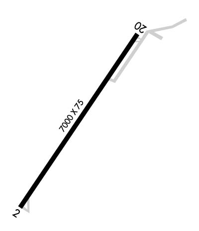
| Lat: N 3539.1 Long: W 10904.0 Elev: 6742 Var: -09 Longest Runway: 7000 | ||
| AWOS: 118.32 CTAF: 122.8 | ||
| ||||||||||||||||||||||||||||||||
| ||||||||||||||||||||||||||||||||
| ||||||||||||||||||||||||||||||||
| Rwy | Rwy | |||||||
| 7000x75 | 7000' | 7000x75 | 7000' | |||||
| Runway ID | Single Wheel | Double Wheel | Double Tandem Wheel | Dual Double Wheel |
| 03/21 | 30,000 | 45,000 | 75,000 | N/A |
| These numbers are Advisory and are not limits. The Airport Manager should have more accurate Weight Limits | ||||
 Airport Diagram might not be current. | |
| Facility Name: | WINDOW ROCK |
| City Name: | WINDOW ROCK |
| County: | APACHE |
| State abbrev: | AZ |
| State Name: | ARIZONA |
| Ownership: | PUBLICLY OWNED |
| Use: | OPEN TO THE PUBLIC |
| Owner's Name: | NAVAJO NATION-C/O NAVAJO DOT |
| Address: | P.O. BOX 4620 |
| WINDOW ROCK, AZ 86515 | |
| Owner's Phone: | 505-371-8320 |
| Manager's Name: | KYRON HARDY |
| Address: | P.O. BOX 706 |
| WINDOW ROCK, AZ 86515 | |
| Phone: | 505-371-8323 |
| FAA Region: | WESTERN-PACIFIC |
| FAA Field Office: | PHX |
| Date | Sunrise | Sunset |
|---|---|---|
| 06/07/26 Sunday | 6:00 | 20:30 |
| 06/08/26 Monday | 6:00 | 20:31 |
| 06/09/26 Tuesday | 6:00 | 20:31 |
| 06/10/26 Wednesday | 6:00 | 20:32 |
| 06/11/26 Thursday | 6:00 | 20:32 |
| 06/12/26 Friday | 6:00 | 20:32 |
| 06/13/26 Saturday | 6:00 | 20:33 |
| 06/14/26 Sunday | 6:00 | 20:33 |
| 06/15/26 Monday | 6:00 | 20:34 |
| 06/16/26 Tuesday | 6:00 | 20:34 |
| 06/17/26 Wednesday | 6:00 | 20:34 |
| 06/18/26 Thursday | 6:00 | 20:35 |
| 06/19/26 Friday | 6:00 | 20:35 |
| 06/20/26 Saturday | 6:01 | 20:35 |
| Airport Attendance Schedule | MON-FRI 0800-1700 |
| Airport Status | OPERATIONAL (This Status can change at any time - please check NOTAMS) |
| Airport Lighting Schedule | ACTVT REIL RWY 03 & 21; MIRL RWY 03/21 - CTAF. |
| Airport Storage Available | Tie Downs |
| Extra Services Available | NONE |
| Wind Indicator | YES - (lighted) |
| Control Tower | NO |
| CTAF Frequency | 122.800 |
| Unicom Frequency | 122.800 |
| Rotating Beacon Color | YELLOW (UNLIGHTED SEAPLANE BASE) |
| Segmented Circle | NO |
| Landing Fee | NO |
| Airport Inspected | STATE - performed by PRIVATE CONTRACT PERSONNEL |
| Inspection Date | 04/17/2025 |
| Type of Fuel Available | None |
| Airframe Repair Service | None |
| Power Plant Repair Service | None |
| Latitude | N3539.1 |
| Longitude | W10904.0 (ESTIMATED) |
| Arpt Elevation | 6742ft (SURVEYED) |
| Magnetic Variation | 09E |
| 1 miles S | of WINDOW ROCK |
| Traffic Pattern Altitude | |
| Sectional Chart | DENVER |
| Operations (Reported) | Yearly | Avg. Daily |
|---|---|---|
| General Aviation Transient | 0 | 0 |
| General Aviation Local | 0 | 0 |
| Air Taxi | 0 | 0 |
| Commerical | 0 | 0 |
| Commuter | 0 | 0 |
| Military | 0 | 0 |
| Aircraft based on Field | |
|---|---|
| General Aviation Singles | 0 |
| General Aviation Multi | 0 |
| Jet Aircraft | 0 |
| General Aviation Helicopters | 0 |
| Military Aircraft | 0 |
| Gliders | 0 |
| Ultralights | 0 |
| FSS on field | NO |
| FSS tie-in | PRESCOTT |
| FSS Phone | 1-800-WX-BRIEF |
| Who issues Notams | RQE |
| Notam D service at airport | YES |
| ARTCC Name | ALBUQUERQUE |
| Airport Certification | |
| Aircraft Rescue & Firefighting Index | None |
| Airport of Entry | No |
| Custom Landing Rights | No |
| Joint Civil/Military | No |
| Military Landing rights | YES |
| NATIONAL PLAN OF INTEGRATED AIRPORT SYSTEMS (NPIAS) |
| GRANT AGREEMENTS UNDER FAAP/ADAP/AIP |
| ASSURANCES PURSUANT TO TITLE VI, CIVIL RIGHTS ACT OF 1964 |
| THIS AIRPORT HAS BEEN SURVEYED BY THE NATIONAL GEODETIC SURVEY. |
| TRRN ALL QUADS. |
| FOR CD CTC ALBUQUERQUE ARTCC AT 505-856-4861. |
| CTN: TURB INVOF ARPT. |
| RWY 03/2 1 RWY 03 TURN AROUND UNUSBL. |
| RWY 03/2 1 S HALF ROUGH. |
Airport Communications & Frequencies:
| |||||||||
| Runway: 03 | Runway: 21 | ||
| Mag heading: | 25° | Mag heading: | 205° |
| Rwy Slope: | .58% Up | Rwy Slope: | -.58% Down |
| Approach: | Approach: | ||
| Pattern: | Left Traffic | Pattern: | Right Traffic |
| Markings: | NONPRECISION INSTRUMENT | Markings: | NONPRECISION INSTRUMENT |
| Marking Condition: | POOR; FADED OR MISG. | Marking Condition: | FAIR |
| Arresting Dev: | Arresting Dev: | ||
| Lat & Long: | N3538.6 W10904.4 | Lat. & Long.: | N3539.6 W10903.6 |
| Elev: | 6701.6 ft. MSL | Elev: | 6742.0 ft. MSL |
| TCH: | 42 ft. AGL | TCH: | |
| Visual Glide Path: | 3.00 degrees | Visual Glide Path: | |
| Displaced Threshold: | No | Displaced Threshold: | No |
| Touchdown Zone: | YES | Touchdown Zone: | YES |
| Touchdown Elev.: | 6719.2 feet | Touchdown Elev.: | 6742.0 feet |
| Visual Glide Slope: | 2-Light PAPI on LEFT side of Runway | Visual Glide Slope: | |
| RVR Equipment: | RVR Equipment: | ||
| RVV Equipment: | NO | RVV Equipment: | NO |
| Approach Lights: | Approach Lights: | ||
| REIL: | YES | REIL: | YES |
| Centerline Lights: | NO | Centerline Lights: | NO |
| Touchdown lights: | NO | Touchdown lights: | NO |
| Runway Category: | Runway with a Non-precision Approach | Runway Category: | Runway with a Visual Approach |
| Declared Distances: | Declared Distances: | ||
| Obstructions: | FENCE | Obstructions: | |
| Marked: | NOT Marked/Lighted | Marked: | |
| Clearance slope: | CTLG OBS EXCEEDS 45 DEG SLOPE. | Clearance slope: | 20:1 |
| Obstruction height: | 5 feet AGL | Obstruction height: | |
| Dist. from runway: | 202 feet | Dist. from runway: | |
| Centerline offset: | Centerline offset: | ||
| Comments: | +6 FT FENCE 0-200 FT FM THR 125 FT L OF CNTRLN. | Comments: | 4 FT FENCE 200 FT FM THR BOTH SIDES. |
Thanks for using FltPlan.com
all rights reserved © 1999-2026 by Flight Plan LLC
