
| ROBEN-HOOD BIG RAPIDS MI |
| |
| Lat: N 4343.4 Long: W 08530.3 Elev: 994 Var: +06 Longest Runway: 5003 | ||
| AWOS: 125.87 CTAF: 122.8 | ||
| ||||||||||||||||||||||||||||||||||||||||||||
| ||||||||||||||||||||||||||||||||||||||||||||
| ||||||||||||||||||||||||||||||||||||||||||||
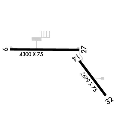
| Rwy | Rwy | |||||||
| 5003x75 | 5003' | 5003x75 | 5003' | |||||
| 2699x75 | 2699' | 2699x75 | 2699' | |||||
| Runway ID | Single Wheel | Double Wheel | Double Tandem Wheel | Dual Double Wheel |
| 10/28 | 62,000 | 87,000 | N/A | N/A |
| 14/32 | 37,000 | 56,000 | N/A | N/A |
| These numbers are Advisory and are not limits. The Airport Manager should have more accurate Weight Limits | ||||
 Airport Diagram might not be current. | |
| Facility Name: | ROBEN-HOOD |
| City Name: | BIG RAPIDS |
| County: | MECOSTA |
| State abbrev: | MI |
| State Name: | MICHIGAN |
| Ownership: | PUBLICLY OWNED |
| Use: | OPEN TO THE PUBLIC |
| Owner's Name: | CITY OF BIG RAPIDS |
| Address: | CITY HALL, 226 N MICHIGAN AVE |
| BIG RAPIDS, MI 49307-1489 | |
| Owner's Phone: | 231-592-4045 |
| Manager's Name: | STEVE SCHROEDER, FIRE CHIEF |
| Address: | 21325 18 MILE RD |
| BIG RAPIDS, MI 49307-9721 | |
| Phone: | 231-796-5600; CITY HALL 231-679-1583. |
| FAA Region: | GREAT LAKES |
| FAA Field Office: | DET |
| Date | Sunrise | Sunset |
|---|---|---|
| 06/07/26 Sunday | 6:01 | 21:21 |
| 06/08/26 Monday | 6:00 | 21:22 |
| 06/09/26 Tuesday | 6:00 | 21:22 |
| 06/10/26 Wednesday | 6:00 | 21:23 |
| 06/11/26 Thursday | 6:00 | 21:24 |
| 06/12/26 Friday | 6:00 | 21:24 |
| 06/13/26 Saturday | 6:00 | 21:25 |
| 06/14/26 Sunday | 6:00 | 21:25 |
| 06/15/26 Monday | 6:00 | 21:25 |
| 06/16/26 Tuesday | 6:00 | 21:26 |
| 06/17/26 Wednesday | 6:00 | 21:26 |
| 06/18/26 Thursday | 6:00 | 21:27 |
| 06/19/26 Friday | 6:00 | 21:27 |
| 06/20/26 Saturday | 6:00 | 21:27 |
| Airport Attendance Schedule | SAT 0800-1500, MON-FRI 0800-1700 |
| Airport Status | OPERATIONAL (This Status can change at any time - please check NOTAMS) |
| Airport Lighting Schedule | ACTVT REIL RWY 10 & 28; PAPI RWY 10 & 28; MIRL RWY 10/28 & 14/32 - CTAF. |
| Airport Storage Available | Tie Downs, Hanger |
| Extra Services Available | Air Ambulance, Flight Instruction, Aircraft Rental |
| Wind Indicator | YES - (lighted) |
| Control Tower | NO |
| CTAF Frequency | 122.800 |
| Unicom Frequency | 122.800 |
| Rotating Beacon Color | WG |
| Segmented Circle | NO |
| Landing Fee | NO; LDG FEE FOR COML ACFT WAIVED WITH MNM FUEL PURCHASE. |
| Airport Inspected | STATE - performed by STATE AERONAUTICAL PERSONNEL |
| Inspection Date | 05/07/2024 |
| Type of Fuel Available | Grade 100LL, JET A; -10AVBL H24 SELF SVC.; -A+SINGLE POINT & OVERWING AVBL. |
| Airframe Repair Service | MAJOR |
| Power Plant Repair Service | MAJOR |
| Latitude | N4343.4 |
| Longitude | W08530.3 (ESTIMATED) |
| Arpt Elevation | 994ft (SURVEYED) |
| Magnetic Variation | 06W |
| 2 miles NW | of BIG RAPIDS |
| Traffic Pattern Altitude | |
| Sectional Chart | CHICAGO |
| Operations (Reported) | Yearly | Avg. Daily |
|---|---|---|
| General Aviation Transient | 0 | 0 |
| General Aviation Local | 0 | 0 |
| Air Taxi | 0 | 0 |
| Commerical | 0 | 0 |
| Commuter | 0 | 0 |
| Military | 0 | 0 |
| Aircraft based on Field | |
|---|---|
| General Aviation Singles | 0 |
| General Aviation Multi | 0 |
| Jet Aircraft | 0 |
| General Aviation Helicopters | 0 |
| Military Aircraft | 0 |
| Gliders | 0 |
| Ultralights | 0 |
| FSS on field | NO |
| FSS tie-in | LANSING |
| FSS Phone | 1-800-WX-BRIEF |
| Who issues Notams | RQB |
| Notam D service at airport | YES |
| ARTCC Name | MINNEAPOLIS |
| Airport Certification | |
| Aircraft Rescue & Firefighting Index | None |
| Airport of Entry | No |
| Custom Landing Rights | No |
| Joint Civil/Military | No |
| Military Landing rights | YES |
| NATIONAL PLAN OF INTEGRATED AIRPORT SYSTEMS (NPIAS) |
| GRANT AGREEMENTS UNDER FAAP/ADAP/AIP |
| ASSURANCES PURSUANT TO TITLE VI, CIVIL RIGHTS ACT OF 1964 |
| BIRDS & DEER ON & INVOF ARPT. |
| ADMIN BLDG ACES: PRESS 5, THEN 3 & 2 SIMUL, THEN 1. |
| FOR CD CTC MINNEAPOLIS ARTCC AT 651-463-5588. |
Airport Communications & Frequencies:
| |||||||||
| Runway: 10 | Runway: 28 | ||
| Mag heading: | 96° | Mag heading: | 276° |
| Rwy Slope: | -.99% Down | Rwy Slope: | .99% Up |
| Approach: | Approach: | ||
| Pattern: | Left Traffic | Pattern: | Left Traffic |
| Markings: | NONPRECISION INSTRUMENT | Markings: | NONPRECISION INSTRUMENT |
| Marking Condition: | GOOD | Marking Condition: | GOOD |
| Arresting Dev: | Arresting Dev: | ||
| Lat & Long: | N4343.5 W08531.2 | Lat. & Long.: | N4343.5 W08530.0 |
| Elev: | 994.2 ft. MSL | Elev: | 944.6 ft. MSL |
| TCH: | 40 ft. AGL | TCH: | 25 ft. AGL |
| Visual Glide Path: | 3.75 degrees | Visual Glide Path: | 3.08 degrees |
| Displaced Threshold: | No | Displaced Threshold: | No |
| Touchdown Zone: | YES | Touchdown Zone: | YES |
| Touchdown Elev.: | 994.2 feet | Touchdown Elev.: | 975.3 feet |
| Visual Glide Slope: | 2-Light PAPI on LEFT side of Runway | Visual Glide Slope: | 4-Light PAPI on LEFT side of Runway |
| RVR Equipment: | RVR Equipment: | ||
| RVV Equipment: | NO | RVV Equipment: | NO |
| Approach Lights: | Approach Lights: | ||
| REIL: | YES | REIL: | YES |
| Centerline Lights: | NO | Centerline Lights: | NO |
| Touchdown lights: | NO | Touchdown lights: | NO |
| Runway Category: | Runway with a Visual Approach | Runway Category: | Runway with a Non-precision Approach |
| Declared Distances: | Declared Distances: |
| Runway: 14 | Runway: 32 | ||
| Mag heading: | 149° | Mag heading: | 329° |
| Rwy Slope: | -.28% Down | Rwy Slope: | .28% Up |
| Approach: | Approach: | ||
| Pattern: | Left Traffic | Pattern: | Left Traffic |
| Markings: | BASIC | Markings: | BASIC |
| Marking Condition: | GOOD | Marking Condition: | GOOD |
| Arresting Dev: | Arresting Dev: | ||
| Lat & Long: | N4343.4 W08530.0 | Lat. & Long.: | N4343.0 W08529.6 |
| Elev: | 932.4 ft. MSL | Elev: | 924.9 ft. MSL |
| TCH: | TCH: | ||
| Visual Glide Path: | Visual Glide Path: | ||
| Displaced Threshold: | No | Displaced Threshold: | No |
| Touchdown Zone: | YES | Touchdown Zone: | YES |
| Touchdown Elev.: | 932.4 feet | Touchdown Elev.: | 932.4 feet |
| Visual Glide Slope: | Visual Glide Slope: | ||
| RVR Equipment: | RVR Equipment: | ||
| RVV Equipment: | NO | RVV Equipment: | NO |
| Approach Lights: | Approach Lights: | ||
| REIL: | NO | REIL: | NO |
| Centerline Lights: | NO | Centerline Lights: | NO |
| Touchdown lights: | NO | Touchdown lights: | NO |
| Runway Category: | Runway with a Visual Approach | Runway Category: | Runway with a Visual Approach |
| Declared Distances: | Declared Distances: |
Thanks for using FltPlan.com
all rights reserved © 1999-2026 by Flight Plan LLC
