| ROUNDUP ROUNDUP MT |
| |
| Lat: N 4628.5 Long: W 10832.6 Elev: 3490 Var: -11 Longest Runway: 5099 | ||
| CTAF: 122.8 | ||
| |||||||||||||||||||||||||||||||||||||||||||||||||||||||||||||
| |||||||||||||||||||||||||||||||||||||||||||||||||||||||||||||
| |||||||||||||||||||||||||||||||||||||||||||||||||||||||||||||
| Rwy | Rwy | |||||||
| 5099x75 | 5099' | 5099x75 | 5099' | |||||
| 2460x100 | 2460' | 2460x100 | 2460' | |||||
| Runway ID | Single Wheel | Double Wheel | Double Tandem Wheel | Dual Double Wheel |
| 07/25 | 12,500 | N/A | N/A | N/A |
| 16/34 | N/A | N/A | N/A | N/A |
| These numbers are Advisory and are not limits. The Airport Manager should have more accurate Weight Limits | ||||
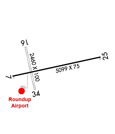 Airport Diagram might not be current. | |
| Facility Name: | ROUNDUP |
| City Name: | ROUNDUP |
| County: | MUSSELSHELL |
| State abbrev: | MT |
| State Name: | MONTANA |
| Ownership: | PUBLICLY OWNED |
| Use: | OPEN TO THE PUBLIC |
| Owner's Name: | ROUNDUP & MUSSELSHELL COUNTY |
| Address: | 506 MAIN ST |
| ROUNDUP, MT 59072 | |
| Owner's Phone: | 406-323-1104 |
| Manager's Name: | KELLY GEBHARDT |
| Address: | 20 SKYLINE DRIVE |
| ROUNDUP, MT 59072 | |
| Phone: | 406-323-1564; OR 406-855-7354 CONTACT FOR SVCS |
| FAA Region: | NORTHWEST MOUNTAIN |
| FAA Field Office: | HLN |
| Date | Sunrise | Sunset |
|---|---|---|
| 06/12/26 Friday | 5:21 | 21:07 |
| 06/13/26 Saturday | 5:21 | 21:08 |
| 06/14/26 Sunday | 5:21 | 21:08 |
| 06/15/26 Monday | 5:21 | 21:09 |
| 06/16/26 Tuesday | 5:21 | 21:09 |
| 06/17/26 Wednesday | 5:21 | 21:09 |
| 06/18/26 Thursday | 5:21 | 21:10 |
| 06/19/26 Friday | 5:21 | 21:10 |
| 06/20/26 Saturday | 5:21 | 21:10 |
| 06/21/26 Sunday | 5:21 | 21:11 |
| 06/22/26 Monday | 5:21 | 21:11 |
| 06/23/26 Tuesday | 5:22 | 21:11 |
| 06/24/26 Wednesday | 5:22 | 21:11 |
| 06/25/26 Thursday | 5:22 | 21:11 |
| Airport Attendance Schedule | UNATTENDED |
| Airport Status | OPERATIONAL (This Status can change at any time - please check NOTAMS) |
| Airport Lighting Schedule | ACTVT MIRL RY 07/25 AND PAPI RY 07 & RY 25 - 122.7. |
| Airport Storage Available | Tie Downs, Hanger |
| Extra Services Available | Crop Dusting, Charter, Flight Instruction, Parachute Jumping, Aircraft Rental, Annual Surveying |
| Wind Indicator | YES - (lighted) |
| Control Tower | NO |
| CTAF Frequency | 122.800 |
| Unicom Frequency | 122.800 |
| Rotating Beacon Color | WG |
| Segmented Circle | YES |
| Landing Fee | NO |
| Airport Inspected | STATE - performed by STATE AERONAUTICAL PERSONNEL |
| Inspection Date | 05/01/2025 |
| Type of Fuel Available | Grade 100LL, JET A-1 (freeze point -50C); -10CREDIT CARD SELF SVC FUEL AVBL 24/7. |
| Airframe Repair Service | MAJOR |
| Power Plant Repair Service | MAJOR |
| Latitude | N4628.5 |
| Longitude | W10832.6 (ESTIMATED) |
| Arpt Elevation | 3490ft (SURVEYED) |
| Magnetic Variation | 11E |
| 2 miles N | of ROUNDUP |
| Traffic Pattern Altitude | |
| Sectional Chart | BILLINGS |
| Operations (Reported) | Yearly | Avg. Daily |
|---|---|---|
| General Aviation Transient | 0 | 0 |
| General Aviation Local | 0 | 0 |
| Air Taxi | 0 | 0 |
| Commerical | 0 | 0 |
| Commuter | 0 | 0 |
| Military | 0 | 0 |
| Aircraft based on Field | |
|---|---|
| General Aviation Singles | 0 |
| General Aviation Multi | 0 |
| Jet Aircraft | 0 |
| General Aviation Helicopters | 0 |
| Military Aircraft | 0 |
| Gliders | 0 |
| Ultralights | 0; ULTRALIGHTS ON & INVOF ARPT. |
| FSS on field | NO |
| FSS tie-in | GREAT FALLS |
| FSS Phone | 1-800-WX-BRIEF |
| Who issues Notams | GTF |
| Notam D service at airport | YES |
| ARTCC Name | SALT LAKE CITY |
| Airport Certification | |
| Aircraft Rescue & Firefighting Index | None |
| Airport of Entry | No |
| Custom Landing Rights | No |
| Joint Civil/Military | No |
| Military Landing rights | YES |
| NATIONAL PLAN OF INTEGRATED AIRPORT SYSTEMS (NPIAS) |
| GRANT AGREEMENTS UNDER FAAP/ADAP/AIP |
| ASSURANCES PURSUANT TO TITLE VI, CIVIL RIGHTS ACT OF 1964 |
| PHONE ON FLD. |
| WILDLIFE ON & INVOF ARPT. |
| FOR CD CTC BILLINGS APCH AT 406-255-2798. |
Airport Communications & Frequencies:
| |||||||||
| Runway: 07 | Runway: 25 | ||
| Mag heading: | 67° | Mag heading: | 247° |
| Rwy Slope: | -1.17% Down | Rwy Slope: | 1.17% Up |
| Approach: | Approach: | ||
| Pattern: | Left Traffic | Pattern: | Left Traffic; RY 25 RIGHT TFC FM 2200 TO 0700. |
| Markings: | NONPRECISION INSTRUMENT | Markings: | NONPRECISION INSTRUMENT |
| Marking Condition: | GOOD | Marking Condition: | GOOD |
| Arresting Dev: | Arresting Dev: | ||
| Lat & Long: | N4628.4 W10833.1 | Lat. & Long.: | N4628.6 W10831.9 |
| Elev: | 3490.3 ft. MSL | Elev: | 3430.8 ft. MSL |
| TCH: | 43 ft. AGL | TCH: | 42 ft. AGL |
| Visual Glide Path: | 4.00 degrees | Visual Glide Path: | 3.00 degrees |
| Displaced Threshold: | No | Displaced Threshold: | No |
| Touchdown Zone: | YES | Touchdown Zone: | YES |
| Touchdown Elev.: | 3490.3 feet | Touchdown Elev.: | 3453.3 feet |
| Visual Glide Slope: | 2-Light PAPI on LEFT side of Runway | Visual Glide Slope: | 2-Light PAPI on LEFT side of Runway |
| RVR Equipment: | RVR Equipment: | ||
| RVV Equipment: | NO | RVV Equipment: | NO |
| Approach Lights: | Approach Lights: | ||
| REIL: | NO | REIL: | NO |
| Centerline Lights: | NO | Centerline Lights: | NO |
| Touchdown lights: | NO | Touchdown lights: | NO |
| Runway Category: | Runway with a Non-precision Approach having visibility minimums greater than 3/4 mile | Runway Category: | Runway with a Non-precision Approach having visibility minimums greater than 3/4 mile |
| Declared Distances: | Declared Distances: | ||
| Obstructions: | GND | Obstructions: | |
| Marked: | NOT Marked/Lighted | Marked: | |
| Clearance slope: | 29:1 | Clearance slope: | 34:1 |
| Obstruction height: | 17 feet AGL | Obstruction height: | |
| Dist. from runway: | 700 feet | Dist. from runway: | |
| Centerline offset: | Centerline offset: | ||
| Comments: | Comments: |
| Runway: 16 | Runway: 34 | ||
| Mag heading: | 157° | Mag heading: | 337° |
| Rwy Slope: | .82% Up | Rwy Slope: | -.82% Down |
| Approach: | Approach: | ||
| Pattern: | Left Traffic | Pattern: | Left Traffic |
| Markings: | Markings: | ||
| Marking Condition: | RY 16/34 MKD WITH WHITE CONES FULL LENGTH; RED CONES MARK THR. | Marking Condition: | |
| Arresting Dev: | Arresting Dev: | ||
| Lat & Long: | N4628.7 W10832.9 | Lat. & Long.: | N4628.3 W10832.8 |
| Elev: | 3462.2 ft. MSL | Elev: | 3482.3 ft. MSL |
| TCH: | TCH: | ||
| Visual Glide Path: | Visual Glide Path: | ||
| Displaced Threshold: | No | Displaced Threshold: | No |
| Touchdown Zone: | YES | Touchdown Zone: | YES |
| Touchdown Elev.: | 3482.3 feet | Touchdown Elev.: | 3482.3 feet |
| Visual Glide Slope: | Visual Glide Slope: | ||
| RVR Equipment: | RVR Equipment: | ||
| RVV Equipment: | NO | RVV Equipment: | NO |
| Approach Lights: | Approach Lights: | ||
| REIL: | NO | REIL: | NO |
| Centerline Lights: | NO | Centerline Lights: | NO |
| Touchdown lights: | NO | Touchdown lights: | NO |
| Runway Category: | Runway with a Visual Approach | Runway Category: | Runway with a Visual Approach |
| Declared Distances: | Declared Distances: |
Thanks for using FltPlan.com
all rights reserved © 1999-2026 by Flight Plan LLC