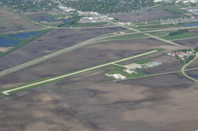
| ROCHELLE MUNI AIRPORT-KORITZ ROCHELLE IL |
| |
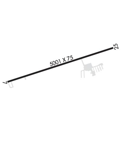
| Lat: N 4153.6 Long: W 08904.8 Elev: 781 Var: +01 Longest Runway: 5001 | ||
| AWOS: 125.2 CTAF: 122.97 | ||
| |||||||||||||||||||||||||||||||||||||||||||||||||||||||||||||
| |||||||||||||||||||||||||||||||||||||||||||||||||||||||||||||
| |||||||||||||||||||||||||||||||||||||||||||||||||||||||||||||
| Rwy | Rwy | |||||||
| 5001x75 | 5001' | 5001x75 | 5001' | |||||
| Runway ID | Single Wheel | Double Wheel | Double Tandem Wheel | Dual Double Wheel |
| 07/25 | 15,000 | N/A | N/A | N/A |
| These numbers are Advisory and are not limits. The Airport Manager should have more accurate Weight Limits | ||||
 Airport Diagram might not be current. | |
| Facility Name: | ROCHELLE MUNI/KORITZ FLD |
| City Name: | ROCHELLE |
| County: | OGLE |
| State abbrev: | IL |
| State Name: | ILLINOIS |
| Ownership: | PUBLICLY OWNED |
| Use: | OPEN TO THE PUBLIC |
| Owner's Name: | CITY OF ROCHELLE |
| Address: | CITY HALL-BOX A |
| ROCHELLE, IL 61068 | |
| Owner's Phone: | 815-562-6161 |
| Manager's Name: | MIKE HUDETZ |
| Address: | 1201 W. GURLER RD. |
| ROCHELLE, IL 61068 | |
| Phone: | 815-562-8619 |
| FAA Region: | GREAT LAKES |
| FAA Field Office: | CHI |
| Date | Sunrise | Sunset |
|---|---|---|
| 09/24/21 Friday | 6:46 | 18:50 |
| 09/25/21 Saturday | 6:47 | 18:49 |
| 09/26/21 Sunday | 6:48 | 18:47 |
| 09/27/21 Monday | 6:49 | 18:45 |
| 09/28/21 Tuesday | 6:50 | 18:44 |
| 09/29/21 Wednesday | 6:51 | 18:42 |
| 09/30/21 Thursday | 6:52 | 18:40 |
| 10/01/21 Friday | 6:53 | 18:38 |
| 10/02/21 Saturday | 6:54 | 18:37 |
| 10/03/21 Sunday | 6:55 | 18:35 |
| 10/04/21 Monday | 6:56 | 18:33 |
| 10/05/21 Tuesday | 6:57 | 18:32 |
| 10/06/21 Wednesday | 6:58 | 18:30 |
| 10/07/21 Thursday | 6:59 | 18:28 |
| Airport Attendance Schedule | 7 Days A Week 0800-1630 |
| Airport Status | OPERATIONAL (This Status can change at any time - please check NOTAMS) |
| Airport Lighting Schedule | ACTVT REIL RWY 07 & 25; PAPI RWY 07 & 25 - CTAF. MIRL RWY 07/25 PRESET ON LOW INTST SS-SR ONLY, INCR INTST - CTAF. |
| Airport Storage Available | Tie Downs, Hanger |
| Extra Services Available | Air Freight, Charter, Flight Instruction, Aircraft Rental, Aircraft Sales |
| Wind Indicator | YES - (lighted) |
| Control Tower | NO |
| CTAF Frequency | 122.975 |
| Unicom Frequency | 122.975 |
| Rotating Beacon Color | CLEAR-GREEN (Light Land Airport) |
| Segmented Circle | NO |
| Landing Fee | NO |
| Airport Inspected | STATE - performed by STATE AERONAUTICAL PERSONNEL |
| Inspection Date | 08/03/2018 |
| Type of Fuel Available | Grade 100LL, JET A (freeze point -40C) |
| Airframe Repair Service | MAJOR |
| Power Plant Repair Service | MAJOR |
| Latitude | N4153.6 |
| Longitude | W08904.8 (ESTIMATED) |
| Arpt Elevation | 780ft (SURVEYED) |
| Magnetic Variation | 01W |
| 2 miles S | of ROCHELLE |
| Traffic Pattern Altitude | |
| Sectional Chart | CHICAGO |
| Operations (Reported) | Yearly | Avg. Daily |
|---|---|---|
| General Aviation Transient | 4000 | 11 |
| General Aviation Local | 8000 | 22 |
| Air Taxi | 0 | 0 |
| Commerical | 0 | 0 |
| Commuter | 0 | 0 |
| Military | 0 | 0 |
| Aircraft based on Field | |
|---|---|
| General Aviation Singles | 32 |
| General Aviation Multi | 1 |
| Jet Aircraft | 0 |
| General Aviation Helicopters | 0 |
| Military Aircraft | 0 |
| Gliders | 0 |
| Ultralights | 9 |
| FSS on field | NO |
| FSS tie-in | KANKAKEE |
| FSS Phone | 1-800-WX-BRIEF |
| Who issues Notams | RPJ |
| Notam D service at airport | YES |
| ARTCC Name | CHICAGO |
| Airport Certification | |
| Aircraft Rescue & Firefighting Index | None |
| Airport of Entry | No |
| Custom Landing Rights | No |
| Joint Civil/Military | No |
| Military Landing rights | YES |
| NATIONAL PLAN OF INTEGRATED AIRPORT SYSTEMS (NPIAS) |
| GRANT AGREEMENTS UNDER FAAP/ADAP/AIP |
| ASSURANCES PURSUANT TO TITLE VI, CIVIL RIGHTS ACT OF 1964 |
| PAJA ON AND INVOF ARPT. |
| BIRDS INVOF ARPT. |
| FOR CD CTC CHICAGO ARTCC AT 630-906-8921. |
Airport Communications & Frequencies:
| ||||||||||||||
| Runway: 07 | Runway: 25 | ||
| Mag heading: | 71° | Mag heading: | 251° |
| Rwy Slope: | .17% Up | Rwy Slope: | -.17% Down |
| Approach: | Approach: | ||
| Pattern: | Left Traffic | Pattern: | Left Traffic |
| Markings: | NONPRECISION INSTRUMENT | Markings: | NONPRECISION INSTRUMENT |
| Marking Condition: | GOOD | Marking Condition: | FAIR |
| Arresting Dev: | Arresting Dev: | ||
| Lat & Long: | N4153.4 W08905.3 | Lat. & Long.: | N4153.7 W08904.3 |
| Elev: | 772.2 ft. MSL | Elev: | 780.9 ft. MSL |
| TCH: | 22 ft. AGL | TCH: | 28 ft. AGL |
| Visual Glide Path: | 3.00 degrees | Visual Glide Path: | 4.00 degrees |
| Displaced Threshold: | No | Displaced Threshold: | No |
| Touchdown Zone: | YES | Touchdown Zone: | YES |
| Touchdown Elev.: | 775.0 feet | Touchdown Elev.: | 780.9 feet |
| Visual Glide Slope: | 4-Light PAPI on LEFT side of Runway | Visual Glide Slope: | 4-Light PAPI on LEFT side of Runway |
| RVR Equipment: | RVR Equipment: | ||
| RVV Equipment: | NO | RVV Equipment: | NO |
| Approach Lights: | Approach Lights: | ||
| REIL: | YES | REIL: | YES |
| Centerline Lights: | NO | Centerline Lights: | NO |
| Touchdown lights: | NO | Touchdown lights: | NO |
| Runway Category: | Runway with a Non-precision Approach having visibility minimums greater than 3/4 mile | Runway Category: | Runway with a Non-precision Approach having visibility minimums greater than 3/4 mile |
| Declared Distances: | Declared Distances: |
Thanks for using FltPlan.com
all rights reserved © 1999-2021 by Flight Plan LLC