
| ROSWELL INTL AIR CENTER ROSWELL NM |
| |
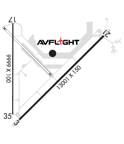
| Lat: N 3318.0 Long: W 10431.8 Elev: 3671 Var: -10 Longest Runway: 13000 | ||
| Clr Del: 132.87 Dept. ATIS: 128.45 Arr. ATIS: 128.45 Ground: 121.9 Tower: 118.5 | ||
| ||||||||||||||||||||||||||||||||||||||||||||
| ||||||||||||||||||||||||||||||||||||||||||||
| ||||||||||||||||||||||||||||||||||||||||||||
| Rwy | Rwy | |||||||
| 13000x150 | 13000' | 13000x150 | 13000' | 109.90 - 215° | ||||
| 10008x100 | 10008' | 10008x100 | 10008' | |||||
| Runway ID | Single Wheel | Double Wheel | Double Tandem Wheel | Dual Double Wheel |
| 03/21 | 100,000 | 200,000 | 400,000 | N/A |
| 17/35 | 77,000 | 104,000 | 165,000 | N/A |
| H1 | N/A | N/A | N/A | N/A |
| H2 | N/A | N/A | N/A | N/A |
| These numbers are Advisory and are not limits. The Airport Manager should have more accurate Weight Limits | ||||
 Airport Diagram might not be current. | |
| Facility Name: | ROSWELL AIR CENTER |
| City Name: | ROSWELL |
| County: | CHAVES |
| State abbrev: | NM |
| State Name: | NEW MEXICO |
| Ownership: | PUBLICLY OWNED |
| Use: | OPEN TO THE PUBLIC |
| Owner's Name: | CITY OF ROSWELL; J GRIEGO. |
| Address: | 425 N RICHARDSON AVE |
| ROSWELL, NM 88201-4730 | |
| Owner's Phone: | 575-624-6700 |
| Manager's Name: | BOBBI THOMPSON |
| Address: | 1 JERRY SMITH CIR |
| ROSWELL, NM 88203-8427 | |
| Phone: | 239-980-5114 |
| FAA Region: | SOUTHWEST |
| FAA Field Office: | LNM |
| Date | Sunrise | Sunset |
|---|---|---|
| 06/08/26 Monday | 5:48 | 20:06 |
| 06/09/26 Tuesday | 5:48 | 20:07 |
| 06/10/26 Wednesday | 5:48 | 20:07 |
| 06/11/26 Thursday | 5:48 | 20:07 |
| 06/12/26 Friday | 5:48 | 20:08 |
| 06/13/26 Saturday | 5:48 | 20:08 |
| 06/14/26 Sunday | 5:48 | 20:09 |
| 06/15/26 Monday | 5:48 | 20:09 |
| 06/16/26 Tuesday | 5:48 | 20:09 |
| 06/17/26 Wednesday | 5:48 | 20:10 |
| 06/18/26 Thursday | 5:49 | 20:10 |
| 06/19/26 Friday | 5:49 | 20:10 |
| 06/20/26 Saturday | 5:49 | 20:10 |
| 06/21/26 Sunday | 5:49 | 20:11 |
| Airport Attendance Schedule | 7 Days A Week 0600-2100; AFT HR - 575-347-2054 OR 575-626-3697. |
| Airport Status | OPERATIONAL (This Status can change at any time - please check NOTAMS) |
| Airport Lighting Schedule | ACTVT MALSR RWY 21; MIRL RWY 17/35 - CTAF. VASI RWY 03; PAPI RWY 17 & 35 - ON CONSLY. WHEN ATCT CLSD MIRL RWY 03/21 ON MED INTST. |
| Airport Storage Available | Tie Downs, Hanger |
| Extra Services Available | Air Freight, Air Ambulance, Flight Instruction |
| Wind Indicator | YES - (lighted) |
| Control Tower | YES |
| CTAF Frequency | 118.500 |
| Unicom Frequency | 122.950 |
| Rotating Beacon Color | WG |
| Segmented Circle | YES |
| Landing Fee | NO |
| Airport Inspected | FEDERAL - performed by FAA AIRPORTS FIELD PERSONNEL |
| Inspection Date | 04/25/2019 |
| Type of Fuel Available | Grade 100LL, JET A (freeze point -40C), JET A-1 (icing inhibitor, freeze point -50C); -10AFT HR - 575-347-2054. |
| Airframe Repair Service | MINOR |
| Power Plant Repair Service | MINOR |
| Latitude | N3318.0 |
| Longitude | W10431.8 (ESTIMATED) |
| Arpt Elevation | 3671ft (SURVEYED) |
| Magnetic Variation | 10E |
| 3 miles S | of ROSWELL |
| Traffic Pattern Altitude | |
| Sectional Chart | ALBUQUERQUE |
| Operations (Reported) | Yearly | Avg. Daily |
|---|---|---|
| General Aviation Transient | 0 | 0 |
| General Aviation Local | 0 | 0 |
| Air Taxi | 0 | 0 |
| Commerical | 0 | 0 |
| Commuter | 0 | 0 |
| Military | 0 | 0 |
| Aircraft based on Field | |
|---|---|
| General Aviation Singles | 0 |
| General Aviation Multi | 0 |
| Jet Aircraft | 0 |
| General Aviation Helicopters | 0 |
| Military Aircraft | 0 |
| Gliders | 0 |
| Ultralights | 0 |
| FSS on field | NO |
| FSS tie-in | ALBUQUERQUE |
| FSS Phone | 1-800-WX-BRIEF |
| Who issues Notams | ROW |
| Notam D service at airport | YES |
| ARTCC Name | ALBUQUERQUE |
| Airport Certification | AIRPORT RECEIVING SCHEDULED AIR CARRIER SERVICE FROM CARRIERS CERTIFICATED BY THE CIVIL AERONAUTICS BOARD |
| Aircraft Rescue & Firefighting Index | AIRPORT HAS A CERTIFICATE UNDER CFR PART 139 |
| Airport of Entry | No |
| Custom Landing Rights | YES |
| Joint Civil/Military | No |
| Military Landing rights | YES |
| NATIONAL PLAN OF INTEGRATED AIRPORT SYSTEMS (NPIAS) |
| GRANT AGREEMENTS UNDER FAAP/ADAP/AIP |
| SURPLUS PROPERTY AGREEMENT UNDER PUBLIC LAW 289 |
| ASSURANCES PURSUANT TO TITLE VI, CIVIL RIGHTS ACT OF 1964 |
| AFT HR EXIT RAMP/FBO AREA USE LGTD PEDESTRIAN GATE - 575-347-2054. |
| BIRDS ON & INVOF ARPT. |
| LRG ACFT LONG TERM STORAGE AVBL. |
| FOR CD IF UNA TO CTC ON FSS FREQ, CTC ALBUQUERQUE ARTCC AT 505-856-4561. |
| RWY 03/2 1 PCR VALUE: 1140/R/C/W/T |
| RWY 17/3 5 PCR VALUE: 150/R/C/W/T |
| RWY 03/2 1 NSTD 75 FT FM RWY EDGE. |
Airport Communications & Frequencies:
| |||||||||||||||||||||||||||||||||||||||||||||
| Runway: 03 | Runway: 21 | ||
| Mag heading: | 35° | Mag heading: | 215° |
| Rwy Slope: | -.33% Down | Rwy Slope: | .33% Up |
| Approach: | Approach: | ILS/DME | |
| Pattern: | Right Traffic | Pattern: | Left Traffic |
| Markings: | NONPRECISION INSTRUMENT | Markings: | PRECISION INSTRUMENT |
| Marking Condition: | GOOD | Marking Condition: | GOOD |
| Arresting Dev: | Arresting Dev: | ||
| Lat & Long: | N3317.2 W10432.2 | Lat. & Long.: | N3318.7 W10430.4 |
| Elev: | 3667.2 ft. MSL | Elev: | 3623.7 ft. MSL |
| TCH: | 48 ft. AGL | TCH: | |
| Visual Glide Path: | 3.00 degrees | Visual Glide Path: | |
| Displaced Threshold: | No | Displaced Threshold: | No |
| Touchdown Zone: | YES | Touchdown Zone: | YES |
| Touchdown Elev.: | 3667.2 feet | Touchdown Elev.: | 3633.3 feet |
| Visual Glide Slope: | 6-BOX VASI ON LEFT SIDE OF RUNWAY | Visual Glide Slope: | |
| RVR Equipment: | RVR Equipment: | ||
| RVV Equipment: | NO | RVV Equipment: | NO |
| Approach Lights: | Approach Lights: | MALSR - 1,400 foot medium intensity approach lighting system with runway alignment indicator lights | |
| REIL: | NO | REIL: | NO |
| Centerline Lights: | NO | Centerline Lights: | NO |
| Touchdown lights: | NO | Touchdown lights: | NO |
| Runway Category: | Runway with a Non-precision Approach having visibility minimums greater than 3/4 mile | Runway Category: | Precision Instrument Runway |
| Declared Distances: | TORA:13000' TODA:13000' ASDA:13000' LDA:13000' | Declared Distances: | TORA:13000' TODA:13000' ASDA:13000' LDA:13000' |
| Runway: 17 | Runway: 35 | ||
| Mag heading: | 170° | Mag heading: | 350° |
| Rwy Slope: | .09% Up | Rwy Slope: | -.09% Down |
| Approach: | Approach: | ||
| Pattern: | Right Traffic | Pattern: | Left Traffic |
| Markings: | PRECISION INSTRUMENT | Markings: | PRECISION INSTRUMENT |
| Marking Condition: | GOOD | Marking Condition: | GOOD |
| Arresting Dev: | Arresting Dev: | ||
| Lat & Long: | N3318.9 W10432.4 | Lat. & Long.: | N3317.3 W10432.4 |
| Elev: | 3662.4 ft. MSL | Elev: | 3671.0 ft. MSL |
| TCH: | 49 ft. AGL | TCH: | 49 ft. AGL |
| Visual Glide Path: | 3.00 degrees | Visual Glide Path: | 3.00 degrees |
| Displaced Threshold: | No | Displaced Threshold: | No |
| Touchdown Zone: | YES | Touchdown Zone: | YES |
| Touchdown Elev.: | 3666.2 feet | Touchdown Elev.: | 3671.0 feet |
| Visual Glide Slope: | 4-Light PAPI on LEFT side of Runway; PAPI UNUSBL BYD 8 DEG RIGHT OF CNTRLN. | Visual Glide Slope: | 4-Light PAPI on LEFT side of Runway |
| RVR Equipment: | RVR Equipment: | ||
| RVV Equipment: | NO | RVV Equipment: | NO |
| Approach Lights: | Approach Lights: | ||
| REIL: | NO | REIL: | NO |
| Centerline Lights: | NO | Centerline Lights: | NO |
| Touchdown lights: | NO | Touchdown lights: | NO |
| Runway Category: | Runway with a Visual Approach | Runway Category: | Runway with a Non-precision Approach having visibility minimums greater than 3/4 mile |
| Declared Distances: | TORA:10008' TODA:10008' ASDA:10008' LDA:10008' | Declared Distances: | TORA:10008' TODA:10008' ASDA:10008' LDA:10008' |
Thanks for using FltPlan.com
all rights reserved © 1999-2026 by Flight Plan LLC
