
| RUSH CITY RGNL RUSH CITY MN |
| |
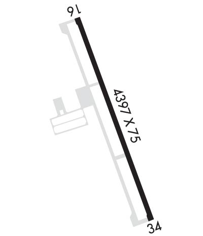
| Lat: N 4541.8 Long: W 09257.1 Elev: 926 Var: -02 Longest Runway: 4401 | ||
| Clr Del: 121.72 GCO AWOS: 118.8 CTAF: 122.9 | ||
| ||||||
| ||||||
|
| Rwy | Rwy | |||||||
| 4401x75 | 4401' | 4401x75 | 4401' | |||||
| Runway ID | Single Wheel | Double Wheel | Double Tandem Wheel | Dual Double Wheel |
| 16/34 | N/A | N/A | N/A | N/A |
| These numbers are Advisory and are not limits. The Airport Manager should have more accurate Weight Limits | ||||
 Airport Diagram might not be current. | |
| Facility Name: | RUSH CITY RGNL |
| City Name: | RUSH CITY |
| County: | CHISAGO |
| State abbrev: | MN |
| State Name: | MINNESOTA |
| Ownership: | PUBLICLY OWNED |
| Use: | OPEN TO THE PUBLIC |
| Owner's Name: | CITY OF RUSH CITY |
| Address: | PO BOX 556 |
| RUSH CITY, MN 55069-0556 | |
| Owner's Phone: | 612-358-4744 |
| Manager's Name: | MARK NELSON |
| Address: | 54175 FOREST BLVD |
| RUSH CITY, MN 55069-2291 | |
| Phone: | 320-358-3665; CELL 612-554-7872. |
| FAA Region: | GREAT LAKES |
| FAA Field Office: | DMA |
| Date | Sunrise | Sunset |
|---|---|---|
| 09/24/21 Friday | 7:01 | 19:06 |
| 09/25/21 Saturday | 7:02 | 19:04 |
| 09/26/21 Sunday | 7:03 | 19:02 |
| 09/27/21 Monday | 7:05 | 19:00 |
| 09/28/21 Tuesday | 7:06 | 18:58 |
| 09/29/21 Wednesday | 7:07 | 18:56 |
| 09/30/21 Thursday | 7:09 | 18:54 |
| 10/01/21 Friday | 7:10 | 18:52 |
| 10/02/21 Saturday | 7:11 | 18:50 |
| 10/03/21 Sunday | 7:12 | 18:49 |
| 10/04/21 Monday | 7:14 | 18:47 |
| 10/05/21 Tuesday | 7:15 | 18:45 |
| 10/06/21 Wednesday | 7:16 | 18:43 |
| 10/07/21 Thursday | 7:17 | 18:41 |
| Airport Attendance Schedule | MON-FRI 0700-1530, SAT 0900-1530 |
| Airport Status | OPERATIONAL (This Status can change at any time - please check NOTAMS) |
| Airport Lighting Schedule | ACTIVATE REIL RWY 16 & 34; PAPI RWY 16 & 34; MIRL RWY 16/34 PRESET TO LOW, INCR INTST AND ACTIVATE - CTAF |
| Airport Storage Available | Tie Downs, Hanger |
| Extra Services Available | Flight Instruction, Aircraft Rental, Aircraft Sales |
| Wind Indicator | YES - (lighted) |
| Control Tower | NO |
| CTAF Frequency | 122.900 |
| Unicom Frequency | |
| Rotating Beacon Color | CLEAR-GREEN (Light Land Airport) |
| Segmented Circle | NO |
| Landing Fee | NO |
| Airport Inspected | STATE - performed by STATE AERONAUTICAL PERSONNEL |
| Inspection Date | 05/26/2021 |
| Type of Fuel Available | Grade 100LL, JET A (freeze point -40C); -10SELF SVC FUEL AVBL 24 HOURS WITH CREDIT CARD. |
| Airframe Repair Service | NONE |
| Power Plant Repair Service | NONE |
| Latitude | N4541.8 |
| Longitude | W09257.1 (ESTIMATED) |
| Arpt Elevation | 926ft (SURVEYED) |
| Magnetic Variation | 02E |
| 1 miles NE | of RUSH CITY |
| Traffic Pattern Altitude | |
| Sectional Chart | GREEN BAY |
| Operations (Reported) | Yearly | Avg. Daily |
|---|---|---|
| General Aviation Transient | 2800 | 8 |
| General Aviation Local | 5000 | 14 |
| Air Taxi | 0 | 0 |
| Commerical | 0 | 0 |
| Commuter | 0 | 0 |
| Military | 10 | 0 |
| Aircraft based on Field | |
|---|---|
| General Aviation Singles | 34 |
| General Aviation Multi | 1 |
| Jet Aircraft | 0 |
| General Aviation Helicopters | 0 |
| Military Aircraft | 0 |
| Gliders | 0 |
| Ultralights | 1 |
| FSS on field | NO |
| FSS tie-in | PRINCETON |
| FSS Phone | 1-800-WX-BRIEF |
| Who issues Notams | ROS |
| Notam D service at airport | YES |
| ARTCC Name | MINNEAPOLIS |
| Airport Certification | |
| Aircraft Rescue & Firefighting Index | None |
| Airport of Entry | No |
| Custom Landing Rights | No |
| Joint Civil/Military | No |
| Military Landing rights | YES |
| NATIONAL PLAN OF INTEGRATED AIRPORT SYSTEMS (NPIAS) |
| GRANT AGREEMENTS UNDER FAAP/ADAP/AIP |
| ASSURANCES PURSUANT TO TITLE VI, CIVIL RIGHTS ACT OF 1964 |
| GCO AVBL ON FREQ 121.725 THRU MINNEAPOLIS ARTCC & FLT SVCS. |
| FOR TRANSIENT HANGAR CONTACT FBO OR ARPT MGR |
| FOR CD IF UNA VIA GCO CTC MINNEAPOLIS ARTCC AT 651-463-5588. |
Airport Communications & Frequencies:
| |||||||
| Runway: 16 | Runway: 34 | ||
| Mag heading: | 159° | Mag heading: | 339° |
| Rwy Slope: | -.14% Down | Rwy Slope: | .14% Up |
| Approach: | Approach: | ||
| Pattern: | Left Traffic | Pattern: | Left Traffic |
| Markings: | NONPRECISION INSTRUMENT | Markings: | NONPRECISION INSTRUMENT |
| Marking Condition: | GOOD | Marking Condition: | GOOD |
| Arresting Dev: | Arresting Dev: | ||
| Lat & Long: | N4542.2 W09257.3 | Lat. & Long.: | N4541.5 W09257.0 |
| Elev: | 925.7 ft. MSL | Elev: | 919.4 ft. MSL |
| TCH: | 33 ft. AGL | TCH: | 25 ft. AGL |
| Visual Glide Path: | 4.00 degrees | Visual Glide Path: | 3.00 degrees |
| Displaced Threshold: | No | Displaced Threshold: | No |
| Touchdown Zone: | YES | Touchdown Zone: | YES |
| Touchdown Elev.: | 926.4 feet | Touchdown Elev.: | 926.1 feet |
| Visual Glide Slope: | 4-Light PAPI on LEFT side of Runway | Visual Glide Slope: | 4-Light PAPI on LEFT side of Runway |
| RVR Equipment: | RVR Equipment: | ||
| RVV Equipment: | NO | RVV Equipment: | NO |
| Approach Lights: | Approach Lights: | ||
| REIL: | YES | REIL: | YES |
| Centerline Lights: | NO | Centerline Lights: | NO |
| Touchdown lights: | NO | Touchdown lights: | NO |
| Runway Category: | Runway with a Visual Approach | Runway Category: | Runway with a Non-precision Approach |
| Declared Distances: | Declared Distances: | ||
| Obstructions: | Obstructions: | TREES | |
| Marked: | Marked: | NOT Marked/Lighted | |
| Clearance slope: | 20:1 | Clearance slope: | 19:1 |
| Obstruction height: | Obstruction height: | 23 feet AGL | |
| Dist. from runway: | Dist. from runway: | 644 feet | |
| Centerline offset: | Centerline offset: | 26 feet left of centerline | |
| Comments: | Comments: |
Thanks for using FltPlan.com
all rights reserved © 1999-2021 by Flight Plan LLC
