
| GREATER ROCHESTER INTL ROCHESTER NY |
| |
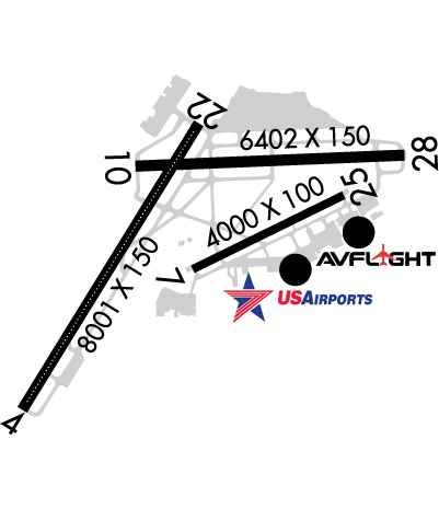
| Lat: N 4307.1 Long: W 07740.3 Elev: 559 Var: +12 Longest Runway: 8001 | ||
| Clr Del: 118.8 Dept. ATIS: 124.82 Arr. ATIS: 124.82 Ground: 121.7 Tower: 118.3 | ||
| |||||||||||||||||||||||||||||||||||||||||||||||||||||||||||||||||||||
| |||||||||||||||||||||||||||||||||||||||||||||||||||||||||||||||||||||
| |||||||||||||||||||||||||||||||||||||||||||||||||||||||||||||||||||||
| |||||||||||||||||||||||||||||||||||||||||||||||||||||||||||||||||||||
| Rwy | Rwy | |||||||
| 8001x150 | 8001' | 110.70 - 043° | 8001x150 | 8001' | 110.70 - 223° | |||
| 4000x100 | 4000' | 4000x100 | 4000' | |||||
| 6402x150 | 6104' | 6402x150 | 5802' | 109.50 - 279° | ||||
| Runway ID | Single Wheel | Double Wheel | Double Tandem Wheel | Dual Double Wheel |
| 04/22 | 126,000 | 160,000 | 265,000 | N/A |
| 07/25 | 32,000 | 42,000 | N/A | N/A |
| 10/28 | 126,000 | 160,000 | 265,000 | N/A |
| These numbers are Advisory and are not limits. The Airport Manager should have more accurate Weight Limits | ||||
 Airport Diagram might not be current. | |
| Facility Name: | FREDERICK DOUGLASS - GREATER ROCHESTER INTL |
| City Name: | ROCHESTER |
| County: | MONROE |
| State abbrev: | NY |
| State Name: | NEW YORK |
| Ownership: | PUBLICLY OWNED |
| Use: | OPEN TO THE PUBLIC |
| Owner's Name: | COUNTY OF MONROE |
| Address: | COUNTY OFFICE BLDG |
| ROCHESTER, NY 14614 | |
| Owner's Phone: | 585-753-7020 |
| Manager's Name: | ANDREW MOORE |
| Address: | 1200 BROOKS AVE |
| ROCHESTER, NY 14624 | |
| Phone: | 585-753-7056 |
| FAA Region: | EASTERN |
| FAA Field Office: | NYC |

| Date | Sunrise | Sunset |
|---|---|---|
| 09/24/21 Friday | 7:00 | 19:05 |
| 09/25/21 Saturday | 7:01 | 19:03 |
| 09/26/21 Sunday | 7:02 | 19:01 |
| 09/27/21 Monday | 7:03 | 18:59 |
| 09/28/21 Tuesday | 7:04 | 18:58 |
| 09/29/21 Wednesday | 7:05 | 18:56 |
| 09/30/21 Thursday | 7:07 | 18:54 |
| 10/01/21 Friday | 7:08 | 18:52 |
| 10/02/21 Saturday | 7:09 | 18:51 |
| 10/03/21 Sunday | 7:10 | 18:49 |
| 10/04/21 Monday | 7:11 | 18:47 |
| 10/05/21 Tuesday | 7:12 | 18:45 |
| 10/06/21 Wednesday | 7:13 | 18:44 |
| 10/07/21 Thursday | 7:15 | 18:42 |
| Airport Attendance Schedule | CONTINUOUS |
| Airport Status | OPERATIONAL (This Status can change at any time - please check NOTAMS) |
| Airport Lighting Schedule | |
| Airport Storage Available | Tie Downs, Hanger |
| Extra Services Available | Avionics, Cargo Handling, Charter, Flight Instruction, Aircraft Rental, Aircraft Sales, Annual Surveying |
| Wind Indicator | YES - (lighted) |
| Control Tower | YES |
| CTAF Frequency | |
| Unicom Frequency | 122.950 |
| Rotating Beacon Color | CLEAR-GREEN (Light Land Airport) |
| Segmented Circle | NO |
| Landing Fee | YES |
| Airport Inspected | FEDERAL - performed by FAA AIRPORTS FIELD PERSONNEL |
| Inspection Date | 06/08/2021 |
| Type of Fuel Available | Grade 100LL, JET A (freeze point -40C)J8; -J8FOR DOD ACFT. |
| Airframe Repair Service | MAJOR |
| Power Plant Repair Service | MAJOR |
| Latitude | N4307.1 |
| Longitude | W07740.3 (ESTIMATED) |
| Arpt Elevation | 558ft (SURVEYED) |
| Magnetic Variation | 12W |
| 3 miles SW | of ROCHESTER |
| Traffic Pattern Altitude | 841; TPA: 841 FT AGL SINGL ENG, 1441 FT AGL MULT ENG/TURBOPROP/JET. |
| Sectional Chart | DETROIT |
| Operations (Reported) | Yearly | Avg. Daily |
|---|---|---|
| General Aviation Transient | 21162 | 58 |
| General Aviation Local | 20060 | 55 |
| Air Taxi | 6994 | 19 |
| Commerical | 13179 | 36 |
| Commuter | 0 | 0 |
| Military | 130 | 0 |
| Aircraft based on Field | |
|---|---|
| General Aviation Singles | 44 |
| General Aviation Multi | 12 |
| Jet Aircraft | 21 |
| General Aviation Helicopters | 0 |
| Military Aircraft | 11 |
| Gliders | 0 |
| Ultralights | 0 |
| FSS on field | NO |
| FSS tie-in | BUFFALO |
| FSS Phone | 1-800-WX-BRIEF |
| Who issues Notams | ROC |
| Notam D service at airport | YES |
| ARTCC Name | CLEVELAND |
| Airport Certification | AIRPORT RECEIVING SCHEDULED AIR CARRIER SERVICE FROM CARRIERS CERTIFICATED BY THE CIVIL AERONAUTICS BOARD |
| Aircraft Rescue & Firefighting Index | AIRPORT HAS A CERTIFICATE UNDER CFR PART 139 |
| Airport of Entry | YES; FLIGHT NOTIFICATION SERVICE (ADCUS ) AVAILABLE. |
| Custom Landing Rights | YES |
| Joint Civil/Military | No |
| Military Landing rights | YES |
| NATIONAL PLAN OF INTEGRATED AIRPORT SYSTEMS (NPIAS) |
| GRANT AGREEMENTS UNDER FAAP/ADAP/AIP |
| ASSURANCES PURSUANT TO TITLE VI, CIVIL RIGHTS ACT OF 1964 |
| AGREEMENT UNDER DLAND OR DCLA HAS EXPIRED. |
| NO PRACTICE APCHS OR MAINT ENG RUN-UPS BTN 2300-0600. |
| MULTIPLE UNSHIELDED LGTS IN FINAL APCH AREA RY 28. |
| TWY "A2" CLSD TO HEAVY ACFT. |
| TWY "F" FROM TWY "F1" TO RY 07 CLSD TO ACFT W/WINGSPAN GREATER THAN 100 FT. |
| PAPI RWY 22; PAPI RWY 10, RWY 25 AND RWY 28 OPERATE 24 HRS. |
| TERMINAL RAMP IS UNCONTROLLED. DO NOT CALL FOR PUSH/POWER BACK. ADVISE GROUND CONTROL WHEN READY TO TAXI FOR DEPARTURE. |
| RWY 7/25 CLSD TO SKED ACR OPS MORE THAN 9 PAX SEATS AND NON SKED ACR OPS MORE THAN 30 PAX SEATS. |
| BE ALERT DURG LNDG/TKOF RYS 25 & 28 - THLDS IN CLOSE PROXIMITY TO EACH OTHER. |
| BIRDS; DEER & COYOTE ON & INVOF ARPT. |
| 80 FT OBST LGTD TWR 1250 FT WEST OF RY 04/22 CNTRLN 1000 FT SOUTH OF EXTDD CNTRLN RY 10/28. |
Airport Communications & Frequencies:
| |||||||||||||||||||||||||||||||||||||||||||||||||||
| Runway: 04 | Runway: 22 | ||
| Mag heading: | 44° | Mag heading: | 224° |
| Rwy Slope: | .39% Up | Rwy Slope: | -.39% Down |
| Approach: | ILS | Approach: | ILS |
| Pattern: | Left Traffic | Pattern: | Right Traffic |
| Markings: | PRECISION INSTRUMENT | Markings: | PRECISION INSTRUMENT |
| Marking Condition: | GOOD | Marking Condition: | GOOD |
| Arresting Dev: | Arresting Dev: | ||
| Lat & Long: | N4306.4 W07741.3 | Lat. & Long.: | N4307.5 W07740.3 |
| Elev: | 527.4 ft. MSL | Elev: | 558.9 ft. MSL |
| TCH: | TCH: | 67 ft. AGL | |
| Visual Glide Path: | Visual Glide Path: | 3.00 degrees | |
| Displaced Threshold: | No | Displaced Threshold: | No |
| Touchdown Zone: | YES | Touchdown Zone: | YES |
| Touchdown Elev.: | 535.2 feet | Touchdown Elev.: | 558.9 feet |
| Visual Glide Slope: | Visual Glide Slope: | 4-Light PAPI on LEFT side of Runway | |
| RVR Equipment: | TOUCHDOWN-ROLLOUT | RVR Equipment: | TOUCHDOWN-ROLLOUT |
| RVV Equipment: | NO | RVV Equipment: | NO |
| Approach Lights: | ALSF2 - standard 2,400 foot high intensity approach lighting system with sequenced flashers, Category II or III | Approach Lights: | MALSR - 1,400 foot medium intensity approach lighting system with runway alignment indicator lights |
| REIL: | NO | REIL: | NO |
| Centerline Lights: | YES | Centerline Lights: | YES |
| Touchdown lights: | YES | Touchdown lights: | NO |
| Runway Category: | Precision Instrument Runway | Runway Category: | Precision Instrument Runway |
| Declared Distances: | TORA:8001' TODA:8001' ASDA:8001' LDA:8001' | Declared Distances: | TORA:8001' TODA:8001' ASDA:8001' LDA:8001' |
| Obstructions: | TREES | Obstructions: | TREE |
| Marked: | NOT Marked/Lighted | Marked: | NOT Marked/Lighted |
| Clearance slope: | 32:1 | Clearance slope: | 34:1 |
| Obstruction height: | 89 feet AGL | Obstruction height: | 54 feet AGL |
| Dist. from runway: | 3080 feet | Dist. from runway: | 2080 feet |
| Centerline offset: | 760 right of centerline | Centerline offset: | 520 feet right of centerline |
| Comments: | Comments: |
| Runway: 07 | Runway: 25 | ||
| Mag heading: | 76° | Mag heading: | 256° |
| Rwy Slope: | -.23% Down | Rwy Slope: | .23% Up |
| Approach: | Approach: | ||
| Pattern: | Right Traffic | Pattern: | Left Traffic |
| Markings: | NONPRECISION INSTRUMENT | Markings: | NONPRECISION INSTRUMENT |
| Marking Condition: | GOOD | Marking Condition: | GOOD |
| Arresting Dev: | Arresting Dev: | ||
| Lat & Long: | N4307.0 W07740.4 | Lat. & Long.: | N4307.3 W07739.5 |
| Elev: | 545.0 ft. MSL | Elev: | 536.0 ft. MSL |
| TCH: | TCH: | 40 ft. AGL | |
| Visual Glide Path: | Visual Glide Path: | 3.00 degrees | |
| Displaced Threshold: | No | Displaced Threshold: | No |
| Touchdown Zone: | YES | Touchdown Zone: | YES |
| Touchdown Elev.: | 547.5 feet | Touchdown Elev.: | 547.5 feet |
| Visual Glide Slope: | Visual Glide Slope: | 4-Light PAPI on RIGHT side of Runway | |
| RVR Equipment: | RVR Equipment: | ||
| RVV Equipment: | NO | RVV Equipment: | NO |
| Approach Lights: | Approach Lights: | ||
| REIL: | YES; RY 07 REIL CONTROLLED BY ATCT BUT NOT MONITORED. | REIL: | YES; RY 25 REIL CONTROLLED BY ATCT BUT NOT MONITORED. |
| Centerline Lights: | NO | Centerline Lights: | NO |
| Touchdown lights: | NO | Touchdown lights: | NO |
| Runway Category: | Runway with a Non-precision Approach having visibility minimums greater than 3/4 mile | Runway Category: | Runway with a Non-precision Approach having visibility minimums greater than 3/4 mile |
| Declared Distances: | TORA:4000' TODA:4000' ASDA:4000' LDA:4000' | Declared Distances: | TORA:4000' TODA:4000' ASDA:4000' LDA:4000' |
| Obstructions: | POLE | Obstructions: | TREE |
| Marked: | LIGHTED | Marked: | NOT Marked/Lighted |
| Clearance slope: | 26:1 | Clearance slope: | 30:1 |
| Obstruction height: | 58 feet AGL | Obstruction height: | 82 feet AGL |
| Dist. from runway: | 1740 feet | Dist. from runway: | 2720 feet |
| Centerline offset: | 320 right of centerline | Centerline offset: | 430 feet right of centerline |
| Comments: | Comments: |
| Runway: 10 | Runway: 28 | ||
| Mag heading: | 100° | Mag heading: | 280° |
| Rwy Slope: | -.21% Down | Rwy Slope: | .21% Up |
| Approach: | Approach: | ILS/DME | |
| Pattern: | Right Traffic | Pattern: | Left Traffic |
| Markings: | NONPRECISION INSTRUMENT | Markings: | PRECISION INSTRUMENT |
| Marking Condition: | GOOD | Marking Condition: | GOOD |
| Arresting Dev: | Arresting Dev: | EMAS; ENGINEERED MATERIALS ARRESTING SYSTEM (EMAS) 368 FT IN LENGTH BY 160 FT IN WIDTH LCTD AT THE DER 28. | |
| Lat & Long: | N4307.4 W07740.7 | Lat. & Long.: | N4307.4 W07739.2 |
| Elev: | 554.9 ft. MSL | Elev: | 541.4 ft. MSL |
| TCH: | 53 ft. AGL | TCH: | 57 ft. AGL |
| Visual Glide Path: | 3.00 degrees | Visual Glide Path: | 3.00 degrees |
| Displaced Threshold: | 298 feet | Displaced Threshold: | 600 feet |
| Touchdown Zone: | YES | Touchdown Zone: | YES |
| Touchdown Elev.: | 555.7 feet | Touchdown Elev.: | 555.0 feet |
| Visual Glide Slope: | 4-Light PAPI on LEFT side of Runway | Visual Glide Slope: | 4-Light PAPI on LEFT side of Runway |
| RVR Equipment: | TOUCHDOWN-ROLLOUT | RVR Equipment: | TOUCHDOWN-ROLLOUT |
| RVV Equipment: | NO | RVV Equipment: | NO |
| Approach Lights: | Approach Lights: | MALSR - 1,400 foot medium intensity approach lighting system with runway alignment indicator lights | |
| REIL: | YES; RY 10 REIL CONTROLLED BY ATCT BUT NOT MONITORED. | REIL: | NO |
| Centerline Lights: | NO | Centerline Lights: | NO |
| Touchdown lights: | NO | Touchdown lights: | NO |
| Runway Category: | Runway with a Non-precision Approach having visibility minimums greater than 3/4 mile | Runway Category: | Precision Instrument Runway |
| Declared Distances: | TORA:6402' TODA:6402' ASDA:5802' LDA:5502' | Declared Distances: | TORA:6402' TODA:6402' ASDA:6402' LDA:5802' |
| Obstructions: | TREES | Obstructions: | TREES |
| Marked: | NOT Marked/Lighted | Marked: | NOT Marked/Lighted |
| Clearance slope: | 18:1; RWY 10 APCH RATIO 26:1 TO DSPLCD THLD. | Clearance slope: | 14:1; RWY 28 APCH RATIO 26:1 TO DSPLCD THLD. |
| Obstruction height: | 62 feet AGL | Obstruction height: | 68 feet AGL |
| Dist. from runway: | 1330 feet | Dist. from runway: | 1213 feet |
| Centerline offset: | 460 left of centerline | Centerline offset: | 663 feet right of centerline |
| Comments: | Comments: |
Thanks for using FltPlan.com
all rights reserved © 1999-2021 by Flight Plan LLC