
| STAFFORD RGNL STAFFORD VA |
| |
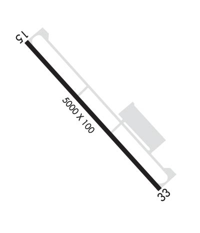
| Lat: N 3823.9 Long: W 07727.3 Elev: 211 Var: +10 Longest Runway: 5000 | ||
| Clr Del: 135.07 GCO AWOS: 126.32 CTAF: 122.72 | ||
| ||||||||||||||||||||||||||||||||||||||||||||
| ||||||||||||||||||||||||||||||||||||||||||||
| ||||||||||||||||||||||||||||||||||||||||||||
| Rwy | Rwy | |||||||
| 5000x100 | 5000' | 5000x100 | 5000' | 108.75 - 329° | ||||
| Runway ID | Single Wheel | Double Wheel | Double Tandem Wheel | Dual Double Wheel |
| 15/33 | 30,000 | 70,000 | N/A | N/A |
| These numbers are Advisory and are not limits. The Airport Manager should have more accurate Weight Limits | ||||
 Airport Diagram might not be current. | |
| Facility Name: | STAFFORD RGNL |
| City Name: | STAFFORD |
| County: | STAFFORD |
| State abbrev: | VA |
| State Name: | VIRGINIA |
| Ownership: | PUBLICLY OWNED |
| Use: | OPEN TO THE PUBLIC |
| Owner's Name: | STATE |
| Address: | 95 AVIATION WAY, PO BOX 370, PO BOX 370 |
| FREDERICKSBURG, VA 22406 | |
| Owner's Phone: | 540-658-1212 |
| Manager's Name: | ED WALLIS |
| Address: | 95 AVIATION WAY, PO BOX 370, PO BOX 370 |
| FREDERICKSBURG, VA 22406 | |
| Phone: | 540-658-1212 |
| FAA Region: | EASTERN |
| FAA Field Office: | DCA |

| Date | Sunrise | Sunset |
|---|---|---|
| 09/24/21 Friday | 6:59 | 19:04 |
| 09/25/21 Saturday | 7:00 | 19:02 |
| 09/26/21 Sunday | 7:01 | 19:01 |
| 09/27/21 Monday | 7:02 | 18:59 |
| 09/28/21 Tuesday | 7:03 | 18:58 |
| 09/29/21 Wednesday | 7:04 | 18:56 |
| 09/30/21 Thursday | 7:04 | 18:55 |
| 10/01/21 Friday | 7:05 | 18:53 |
| 10/02/21 Saturday | 7:06 | 18:52 |
| 10/03/21 Sunday | 7:07 | 18:50 |
| 10/04/21 Monday | 7:08 | 18:48 |
| 10/05/21 Tuesday | 7:09 | 18:47 |
| 10/06/21 Wednesday | 7:10 | 18:45 |
| 10/07/21 Thursday | 7:11 | 18:44 |
| Airport Attendance Schedule | 7 Days A Week 0700-1900; UNATTENDED THANKSGIVING, CHRISTMAS, & NEW YEARS DAYS. |
| Airport Status | OPERATIONAL (This Status can change at any time - please check NOTAMS) |
| Airport Lighting Schedule | ACTVT REIL RWY 15; MALS RWY 33; HIRL RWY 15/33 - CTAF. |
| Airport Storage Available | Tie Downs |
| Extra Services Available | NONE |
| Wind Indicator | YES - (lighted) |
| Control Tower | NO |
| CTAF Frequency | 122.725 |
| Unicom Frequency | 122.725 |
| Rotating Beacon Color | CLEAR-GREEN (Light Land Airport) |
| Segmented Circle | YES |
| Landing Fee |
| Airport Inspected | STATE - performed by STATE AERONAUTICAL PERSONNEL |
| Inspection Date | 05/17/2019 |
| Type of Fuel Available | Grade 100LL, JET A (freeze point -40C); -10FUEL AVBL UNTIL 1900; AFTER HRS CALL 540-288-3838 WITHIN 12 HRS NOTICE. PRIST AVBL.; -A GOVERNMENT CONTRACT FUEL |
| Airframe Repair Service | None |
| Power Plant Repair Service | None |
| Latitude | N3823.9 |
| Longitude | W07727.3 (ESTIMATED) |
| Arpt Elevation | 211ft (SURVEYED) |
| Magnetic Variation | 10W |
| 3 miles SW | of STAFFORD |
| Traffic Pattern Altitude | |
| Sectional Chart | WASHINGTON |
| Operations (Reported) | Yearly | Avg. Daily |
|---|---|---|
| General Aviation Transient | 20313 | 56 |
| General Aviation Local | 7863 | 22 |
| Air Taxi | 0 | 0 |
| Commerical | 0 | 0 |
| Commuter | 0 | 0 |
| Military | 1965 | 5 |
| Aircraft based on Field | |
|---|---|
| General Aviation Singles | 37 |
| General Aviation Multi | 3 |
| Jet Aircraft | 0 |
| General Aviation Helicopters | 6 |
| Military Aircraft | 0 |
| Gliders | 0 |
| Ultralights | 0 |
| FSS on field | NO |
| FSS tie-in | LEESBURG |
| FSS Phone | 1-800-WX-BRIEF |
| Who issues Notams | RMN |
| Notam D service at airport | YES |
| ARTCC Name | WASHINGTON |
| Airport Certification | |
| Aircraft Rescue & Firefighting Index | None |
| Airport of Entry | No |
| Custom Landing Rights | No |
| Joint Civil/Military | No |
| Military Landing rights | No |
| NATIONAL PLAN OF INTEGRATED AIRPORT SYSTEMS (NPIAS) |
| GRANT AGREEMENTS UNDER FAAP/ADAP/AIP |
| ASSURANCES PURSUANT TO TITLE VI, CIVIL RIGHTS ACT OF 1964 |
| DEER & FLOCKS OF BIRDS ON & INVOF ARPT. |
| GCO AVBL ON FREQ 135.075 SERVICED BY QUANTICO AND POTOMAC APPROACH CONTROLS. IF UNA, FOR CD CTC POTOMAC APCH AT 866-709-4993. |
| "FLY FRIENDLY" PROGRAM IN EFFECT, REQUEST THAT TOUCH AND GO ACTIVITY BE LTD TO TWO (2) EVERY HALF HR. |
Airport Communications & Frequencies:
| |||||||||||||||||||||||||
| Runway: 15 | Runway: 33 | ||
| Mag heading: | 149° | Mag heading: | 329° |
| Rwy Slope: | -.80% Down | Rwy Slope: | .80% Up |
| Approach: | Approach: | ILS/DME | |
| Pattern: | Left Traffic | Pattern: | Left Traffic |
| Markings: | NONPRECISION INSTRUMENT | Markings: | PRECISION INSTRUMENT |
| Marking Condition: | GOOD | Marking Condition: | GOOD |
| Arresting Dev: | Arresting Dev: | ||
| Lat & Long: | N3824.2 W07727.7 | Lat. & Long.: | N3823.6 W07727.0 |
| Elev: | 211.2 ft. MSL | Elev: | 171.2 ft. MSL |
| TCH: | 45 ft. AGL | TCH: | 45 ft. AGL |
| Visual Glide Path: | 3.00 degrees | Visual Glide Path: | 3.00 degrees |
| Displaced Threshold: | No | Displaced Threshold: | No |
| Touchdown Zone: | YES | Touchdown Zone: | YES |
| Touchdown Elev.: | 211.2 feet | Touchdown Elev.: | 195.2 feet |
| Visual Glide Slope: | 4-Light PAPI on LEFT side of Runway | Visual Glide Slope: | 4-Light PAPI on LEFT side of Runway |
| RVR Equipment: | RVR Equipment: | ||
| RVV Equipment: | NO | RVV Equipment: | NO |
| Approach Lights: | Approach Lights: | MALS - 1,400 foot medium intensity approach lighting system | |
| REIL: | YES | REIL: | NO |
| Centerline Lights: | NO | Centerline Lights: | NO |
| Touchdown lights: | NO | Touchdown lights: | NO |
| Runway Category: | Runway with a Visual Approach | Runway Category: | Precision Instrument Runway |
| Declared Distances: | Declared Distances: | ||
| Obstructions: | TREES | Obstructions: | TREES |
| Marked: | NOT Marked/Lighted | Marked: | NOT Marked/Lighted |
| Clearance slope: | 20:1 | Clearance slope: | 27:1 |
| Obstruction height: | 70 feet AGL | Obstruction height: | 68 feet AGL |
| Dist. from runway: | 1634 feet | Dist. from runway: | 2065 feet |
| Centerline offset: | 288 right of centerline | Centerline offset: | 766 feet right of centerline |
| Comments: | Comments: |
Thanks for using FltPlan.com
all rights reserved © 1999-2021 by Flight Plan LLC