
| RICHARD B RUSSELL ROME GA |
| |
| Lat: N 3421.1 Long: W 08509.5 Elev: 644 Var: +02 Longest Runway: 7010 | ||
| CTAF: 122.72 | ||
| ||||||||||||||||||||||||||||||||||||||||||||
| ||||||||||||||||||||||||||||||||||||||||||||
| ||||||||||||||||||||||||||||||||||||||||||||
| Rwy | Rwy | |||||||
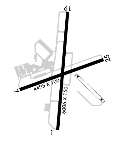
| 7010x150 | 7010' | 111.15 - 006° | 7010x150 | 7010' | ||||
| 4498x100 | 4383' | 4498x100 | 4498' | |||||
| Runway ID | Single Wheel | Double Wheel | Double Tandem Wheel | Dual Double Wheel |
| 01/19 | 52,000 | 57,000 | 114,000 | N/A |
| 07/25 | 16,000 | 30,000 | N/A | N/A |
| These numbers are Advisory and are not limits. The Airport Manager should have more accurate Weight Limits | ||||
 Airport Diagram might not be current. | |
| Facility Name: | RICHARD B RUSSELL RGNL - J H TOWERS FLD |
| City Name: | ROME |
| County: | FLOYD |
| State abbrev: | GA |
| State Name: | GEORGIA |
| Ownership: | PUBLICLY OWNED |
| Use: | OPEN TO THE PUBLIC |
| Owner's Name: | FLOYD COUNTY |
| Address: | PO BOX 946 |
| ROME, GA 30161 | |
| Owner's Phone: | 706-295-7835 |
| Manager's Name: | JOHN CARROLL |
| Address: | 304 RUSSELL FIELD RD NE |
| ROME, GA 30161 | |
| Phone: | 706-295-7835 |
| FAA Region: | SOUTHERN |
| FAA Field Office: | ATL |
| Date | Sunrise | Sunset |
|---|---|---|
| 06/08/26 Monday | 6:28 | 20:51 |
| 06/09/26 Tuesday | 6:28 | 20:52 |
| 06/10/26 Wednesday | 6:28 | 20:52 |
| 06/11/26 Thursday | 6:28 | 20:53 |
| 06/12/26 Friday | 6:28 | 20:53 |
| 06/13/26 Saturday | 6:28 | 20:54 |
| 06/14/26 Sunday | 6:28 | 20:54 |
| 06/15/26 Monday | 6:28 | 20:54 |
| 06/16/26 Tuesday | 6:28 | 20:55 |
| 06/17/26 Wednesday | 6:28 | 20:55 |
| 06/18/26 Thursday | 6:28 | 20:55 |
| 06/19/26 Friday | 6:28 | 20:56 |
| 06/20/26 Saturday | 6:29 | 20:56 |
| 06/21/26 Sunday | 6:29 | 20:56 |
| Airport Attendance Schedule | MON-FRI 0700-2000, SAT-SUN 0900-1800 |
| Airport Status | OPERATIONAL (This Status can change at any time - please check NOTAMS) |
| Airport Lighting Schedule | ACTVT MALSR RWY 01; REIL RWY 07 & 25, 19; PAPI RWY 01 & 19; MIRL RWY 07/25; HIRL RWY 01/19 - CTAF. |
| Airport Storage Available | Tie Downs |
| Extra Services Available | Flight Instruction, Aircraft Rental |
| Wind Indicator | YES - (lighted) |
| Control Tower | NO |
| CTAF Frequency | 122.725 |
| Unicom Frequency | 122.725 |
| Rotating Beacon Color | WG |
| Segmented Circle | YES |
| Landing Fee | NO |
| Airport Inspected | FEDERAL - performed by STATE AERONAUTICAL PERSONNEL |
| Inspection Date | 05/22/2025 |
| Type of Fuel Available | Grade 100LL, JET A |
| Airframe Repair Service | MAJOR |
| Power Plant Repair Service | MAJOR |
| Latitude | N3421.1 |
| Longitude | W08509.5 (ESTIMATED) |
| Arpt Elevation | 644ft (SURVEYED) |
| Magnetic Variation | 02W |
| 6 miles N | of ROME |
| Traffic Pattern Altitude | |
| Sectional Chart | ATLANTA |
| Operations (Reported) | Yearly | Avg. Daily |
|---|---|---|
| General Aviation Transient | 0 | 0 |
| General Aviation Local | 0 | 0 |
| Air Taxi | 0 | 0 |
| Commerical | 0 | 0 |
| Commuter | 0 | 0 |
| Military | 0 | 0 |
| Aircraft based on Field | |
|---|---|
| General Aviation Singles | 0 |
| General Aviation Multi | 0 |
| Jet Aircraft | 0 |
| General Aviation Helicopters | 0 |
| Military Aircraft | 0 |
| Gliders | 0 |
| Ultralights | 0 |
| FSS on field | NO |
| FSS tie-in | MACON |
| FSS Phone | 1-800-WX-BRIEF |
| Who issues Notams | RMG |
| Notam D service at airport | YES |
| ARTCC Name | ATLANTA |
| Airport Certification | |
| Aircraft Rescue & Firefighting Index | None |
| Airport of Entry | No |
| Custom Landing Rights | No |
| Joint Civil/Military | No |
| Military Landing rights | YES |
| NATIONAL PLAN OF INTEGRATED AIRPORT SYSTEMS (NPIAS) |
| GRANT AGREEMENTS UNDER FAAP/ADAP/AIP |
| ASSURANCES PURSUANT TO TITLE VI, CIVIL RIGHTS ACT OF 1964 |
| AGREEMENT UNDER DLAND OR DCLA HAS EXPIRED. |
| ULTRALIGHT ACTIVITY ON & INVOF ARPT. |
| DEER ON INVOF ARPT. |
| MIL AIR CARGO DROP (C130 ACFT) IN PROGRESS 1830-2030 TUE AND THU AT NE END OF RWY 07/25. |
| GCO AVBL ON FREQ 121.725 THRU ATL CLEARANCE DELIVERY. |
| FOR CD IF UNA TO CTC ON FSS FREQ, CTC ATLANTA ARTCC AT 770-210-7692. |
Airport Communications & Frequencies:
| |||||||||
| Runway: 01 | Runway: 19 | ||
| Mag heading: | 7° | Mag heading: | 187° |
| Rwy Slope: | -.15% Down | Rwy Slope: | .15% Up |
| Approach: | ILS/DME | Approach: | |
| Pattern: | Left Traffic | Pattern: | Left Traffic |
| Markings: | PRECISION INSTRUMENT | Markings: | PRECISION INSTRUMENT |
| Marking Condition: | FAIR | Marking Condition: | GOOD |
| Arresting Dev: | Arresting Dev: | ||
| Lat & Long: | N3420.6 W08509.6 | Lat. & Long.: | N3421.7 W08509.4 |
| Elev: | 632.4 ft. MSL | Elev: | 622.1 ft. MSL |
| TCH: | 49 ft. AGL | TCH: | 46 ft. AGL |
| Visual Glide Path: | 3.00 degrees | Visual Glide Path: | 3.00 degrees |
| Displaced Threshold: | No | Displaced Threshold: | No |
| Touchdown Zone: | YES | Touchdown Zone: | YES |
| Touchdown Elev.: | 635.9 feet | Touchdown Elev.: | 630.6 feet |
| Visual Glide Slope: | 4-Light PAPI on LEFT side of Runway | Visual Glide Slope: | 4-Light PAPI on LEFT side of Runway |
| RVR Equipment: | RVR Equipment: | ||
| RVV Equipment: | NO | RVV Equipment: | NO |
| Approach Lights: | MALSR - 1,400 foot medium intensity approach lighting system with runway alignment indicator lights | Approach Lights: | |
| REIL: | NO | REIL: | YES |
| Centerline Lights: | NO | Centerline Lights: | NO |
| Touchdown lights: | NO | Touchdown lights: | NO |
| Runway Category: | Precision Instrument Runway | Runway Category: | Runway with a Non-precision Approach having visibility minimums greater than 3/4 mile |
| Declared Distances: | Declared Distances: | ||
| Obstructions: | TREES | Obstructions: | TREES |
| Marked: | NOT Marked/Lighted | Marked: | NOT Marked/Lighted |
| Clearance slope: | 25:1 | Clearance slope: | 32:1 |
| Obstruction height: | 106 feet AGL | Obstruction height: | 136 feet AGL |
| Dist. from runway: | 2867 feet | Dist. from runway: | 4562 feet |
| Centerline offset: | 666 right of centerline | Centerline offset: | 340 feet right of centerline |
| Comments: | Comments: |
| Runway: 07 | Runway: 25 | ||
| Mag heading: | 72° | Mag heading: | 252° |
| Rwy Slope: | -.40% Down | Rwy Slope: | .40% Up |
| Approach: | Approach: | ||
| Pattern: | Left Traffic | Pattern: | Left Traffic |
| Markings: | NONPRECISION INSTRUMENT | Markings: | NONPRECISION INSTRUMENT |
| Marking Condition: | GOOD | Marking Condition: | GOOD |
| Arresting Dev: | Arresting Dev: | ||
| Lat & Long: | N3420.9 W08509.9 | Lat. & Long.: | N3421.2 W08509.1 |
| Elev: | 644.0 ft. MSL | Elev: | 625.9 ft. MSL |
| TCH: | TCH: | ||
| Visual Glide Path: | Visual Glide Path: | ||
| Displaced Threshold: | 115 feet | Displaced Threshold: | No |
| Touchdown Zone: | YES | Touchdown Zone: | YES |
| Touchdown Elev.: | 643.5 feet | Touchdown Elev.: | 638.0 feet |
| Visual Glide Slope: | Visual Glide Slope: | ||
| RVR Equipment: | RVR Equipment: | ||
| RVV Equipment: | NO | RVV Equipment: | NO |
| Approach Lights: | Approach Lights: | ||
| REIL: | YES | REIL: | YES |
| Centerline Lights: | NO | Centerline Lights: | NO |
| Touchdown lights: | NO | Touchdown lights: | NO |
| Runway Category: | Runway with a Non-precision Approach having visibility minimums greater than 3/4 mile | Runway Category: | Runway with a Non-precision Approach having visibility minimums greater than 3/4 mile |
| Declared Distances: | TORA:4495' TODA:4495' ASDA:4495' LDA:4380' | Declared Distances: | TORA:4495' TODA:4495' ASDA:4495' LDA:4495' |
| Obstructions: | ROAD | Obstructions: | TREE |
| Marked: | NOT Marked/Lighted | Marked: | NOT Marked/Lighted |
| Clearance slope: | 4:1; RWY 07 - APCH RATIO 13:1 AT DSPLCD THLD; 67 FT TREES 1071 FT FM DSPLCD THLD 350 FT L. | Clearance slope: | 15:1 |
| Obstruction height: | 15 feet AGL | Obstruction height: | 51 feet AGL |
| Dist. from runway: | 260 feet | Dist. from runway: | 975 feet |
| Centerline offset: | 300 right of centerline | Centerline offset: | 361 feet left of centerline |
| Comments: | Comments: |
Thanks for using FltPlan.com
all rights reserved © 1999-2026 by Flight Plan LLC
