| RICHLAND RICHLAND WA |
| |
| Lat: N 4618.3 Long: W 11918.3 Elev: 394 Var: -17 Longest Runway: 4009 | ||
| Clr Del: 122.4 AWOS: 132.67 CTAF: 122.7 | ||
| ||||||||||||||||||||||||||||||
| ||||||||||||||||||||||||||||||
| ||||||||||||||||||||||||||||||
| Rwy | Rwy | |||||||
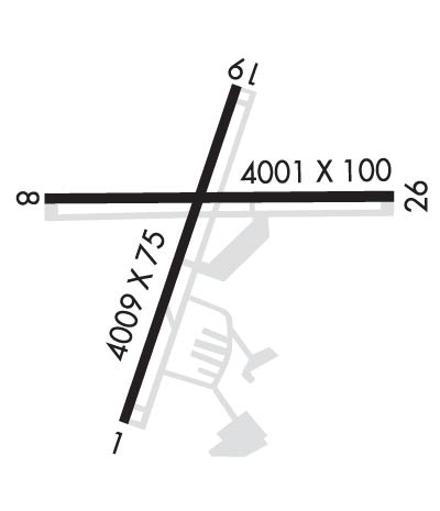
| 4009x75 | 4009' | 4009x75 | 4009' | 110.50 - 188° | ||||
| 4001x100 | 4001' | 4001x100 | 4001' | |||||
| Runway ID | Single Wheel | Double Wheel | Double Tandem Wheel | Dual Double Wheel |
| 01/19 | 30,000 | 45,000 | 70,000 | N/A |
| 08/26 | 30,000 | 45,000 | 70,000 | N/A |
| These numbers are Advisory and are not limits. The Airport Manager should have more accurate Weight Limits | ||||
 Airport Diagram might not be current. | |
| Facility Name: | RICHLAND |
| City Name: | RICHLAND |
| County: | BENTON |
| State abbrev: | WA |
| State Name: | WASHINGTON |
| Ownership: | PUBLICLY OWNED |
| Use: | OPEN TO THE PUBLIC |
| Owner's Name: | PORT OF BENTON |
| Address: | 3250 PORT OF BENTON BLVD |
| RICHLAND, WA 99354 | |
| Owner's Phone: | 509-375-3060 |
| Manager's Name: | QUENTIN WRIGHT |
| Address: | 3250 PORT OF BENTON BLVD |
| RICHLAND, WA 99354 | |
| Phone: | 509-975-6352 |
| FAA Region: | NORTHWEST MOUNTAIN |
| FAA Field Office: | SEA |

| Date | Sunrise | Sunset |
|---|---|---|
| 06/08/26 Monday | 5:06 | 20:47 |
| 06/09/26 Tuesday | 5:05 | 20:48 |
| 06/10/26 Wednesday | 5:05 | 20:48 |
| 06/11/26 Thursday | 5:05 | 20:49 |
| 06/12/26 Friday | 5:05 | 20:50 |
| 06/13/26 Saturday | 5:05 | 20:50 |
| 06/14/26 Sunday | 5:05 | 20:51 |
| 06/15/26 Monday | 5:04 | 20:51 |
| 06/16/26 Tuesday | 5:04 | 20:51 |
| 06/17/26 Wednesday | 5:04 | 20:52 |
| 06/18/26 Thursday | 5:05 | 20:52 |
| 06/19/26 Friday | 5:05 | 20:52 |
| 06/20/26 Saturday | 5:05 | 20:53 |
| 06/21/26 Sunday | 5:05 | 20:53 |
| Airport Attendance Schedule | 7 Days A Week 0800-1800 |
| Airport Status | OPERATIONAL (This Status can change at any time - please check NOTAMS) |
| Airport Lighting Schedule | ACTVT MALS RWY 19; REIL RWYS 01 & 19; MIRL RWY 01/19 & 08/26 - CTAF. VASI RWY 26 & PAPI RWYS 01, 08 & 19 OPR 24 HRS. |
| Airport Storage Available | Tie Downs |
| Extra Services Available | Air Ambulance, Glider, Flight Instruction, Aircraft Rental |
| Wind Indicator | YES - (lighted) |
| Control Tower | NO |
| CTAF Frequency | 122.700 |
| Unicom Frequency | 122.700 |
| Rotating Beacon Color | WG |
| Segmented Circle | YES |
| Landing Fee | NO |
| Airport Inspected | STATE - performed by STATE AERONAUTICAL PERSONNEL |
| Inspection Date | 08/06/2025 |
| Type of Fuel Available | Grade 100LL, JET A (freeze point -40C); -10FUEL BY MAJOR CREDIT CARD - 24 HR AVAILABILITY. |
| Airframe Repair Service | MAJOR |
| Power Plant Repair Service | MAJOR |
| Latitude | N4618.3 |
| Longitude | W11918.3 (ESTIMATED) |
| Arpt Elevation | 394ft (SURVEYED) |
| Magnetic Variation | 17E |
| 2 miles NW | of RICHLAND |
| Traffic Pattern Altitude | 800 |
| Sectional Chart | SEATTLE |
| Operations (Reported) | Yearly | Avg. Daily |
|---|---|---|
| General Aviation Transient | 0 | 0 |
| General Aviation Local | 0 | 0 |
| Air Taxi | 0 | 0 |
| Commerical | 0 | 0 |
| Commuter | 0 | 0 |
| Military | 0 | 0 |
| Aircraft based on Field | |
|---|---|
| General Aviation Singles | 0 |
| General Aviation Multi | 0 |
| Jet Aircraft | 0 |
| General Aviation Helicopters | 0 |
| Military Aircraft | 0 |
| Gliders | 0 |
| Ultralights | 0 |
| FSS on field | NO |
| FSS tie-in | SEATTLE |
| FSS Phone | 1-800-WX-BRIEF |
| Who issues Notams | SEA |
| Notam D service at airport | YES |
| ARTCC Name | SEATTLE |
| Airport Certification | |
| Aircraft Rescue & Firefighting Index | None |
| Airport of Entry | No |
| Custom Landing Rights | No |
| Joint Civil/Military | No |
| Military Landing rights | YES |
| NATIONAL PLAN OF INTEGRATED AIRPORT SYSTEMS (NPIAS) |
| GRANT AGREEMENTS UNDER FAAP/ADAP/AIP |
| SURPLUS PROPERTY AGREEMENT UNDER PUBLIC LAW 289 |
| ASSURANCES PURSUANT TO TITLE VI, CIVIL RIGHTS ACT OF 1964 |
| ROAD 550' WEST APCH END RY 08. |
| (E94) SAWRS;DRCT PHONE LINE TO FSS. |
| PREFERRED RWY 01-19 IN CALM WIND CONDITIONS. |
| AIRFIELD CONDS UNMON NGTS, WKENDS AND HOLS. |
Airport Communications & Frequencies:
| |||||||||||||||||
| Runway: 01 | Runway: 19 | ||
| Mag heading: | 9° | Mag heading: | 189° |
| Rwy Slope: | -.06% Down | Rwy Slope: | .06% Up |
| Approach: | Approach: | LOC/DME | |
| Pattern: | Left Traffic | Pattern: | Right Traffic |
| Markings: | NONPRECISION INSTRUMENT | Markings: | NONPRECISION INSTRUMENT |
| Marking Condition: | GOOD | Marking Condition: | GOOD |
| Arresting Dev: | Arresting Dev: | ||
| Lat & Long: | N4618.0 W11918.5 | Lat. & Long.: | N4618.6 W11918.1 |
| Elev: | 391.5 ft. MSL | Elev: | 389.0 ft. MSL |
| TCH: | 30 ft. AGL | TCH: | 30 ft. AGL |
| Visual Glide Path: | 3.00 degrees | Visual Glide Path: | 3.00 degrees |
| Displaced Threshold: | No | Displaced Threshold: | No |
| Touchdown Zone: | YES | Touchdown Zone: | YES |
| Touchdown Elev.: | 391.5 feet | Touchdown Elev.: | 390.4 feet |
| Visual Glide Slope: | 2-Light PAPI on LEFT side of Runway; PAPI UNUSBL BYD 3.0 NM FM THR FOR TRRN ON RIGHT SIDE OF RWY CNTRLN AT APRXLY 3.5 NM. | Visual Glide Slope: | 2-Light PAPI on LEFT side of Runway |
| RVR Equipment: | RVR Equipment: | ||
| RVV Equipment: | NO | RVV Equipment: | NO |
| Approach Lights: | Approach Lights: | MALS - 1,400 foot medium intensity approach lighting system | |
| REIL: | YES | REIL: | YES |
| Centerline Lights: | NO | Centerline Lights: | NO |
| Touchdown lights: | NO | Touchdown lights: | NO |
| Runway Category: | Runway with a Visual Approach | Runway Category: | D |
| Declared Distances: | Declared Distances: | ||
| Obstructions: | ANT | Obstructions: | POLE |
| Marked: | MARKED | Marked: | NOT Marked/Lighted |
| Clearance slope: | 15:1 | Clearance slope: | 24:1 |
| Obstruction height: | 13 feet AGL | Obstruction height: | 24 feet AGL |
| Dist. from runway: | 396 feet | Dist. from runway: | 795 feet |
| Centerline offset: | 258 right of centerline | Centerline offset: | 444 feet left of centerline |
| Comments: | CLOSE-IN OBSTN GND. | Comments: |
| Runway: 08 | Runway: 26 | ||
| Mag heading: | 78° | Mag heading: | 258° |
| Rwy Slope: | -.15% Down | Rwy Slope: | .15% Up |
| Approach: | Approach: | ||
| Pattern: | Left Traffic | Pattern: | Right Traffic |
| Markings: | NONPRECISION INSTRUMENT | Markings: | NONPRECISION INSTRUMENT |
| Marking Condition: | GOOD | Marking Condition: | GOOD |
| Arresting Dev: | Arresting Dev: | ||
| Lat & Long: | N4618.4 W11918.7 | Lat. & Long.: | N4618.4 W11917.7 |
| Elev: | 394.3 ft. MSL | Elev: | 388.1 ft. MSL |
| TCH: | 40 ft. AGL | TCH: | 52 ft. AGL |
| Visual Glide Path: | 3.00 degrees | Visual Glide Path: | 3.00 degrees |
| Displaced Threshold: | No | Displaced Threshold: | No |
| Touchdown Zone: | YES | Touchdown Zone: | YES |
| Touchdown Elev.: | 394.3 feet | Touchdown Elev.: | 390.0 feet |
| Visual Glide Slope: | 2-Light PAPI on LEFT side of Runway; UNUSBL BYD 8 DEG RIGHT OF CNTRLN. | Visual Glide Slope: | 4-BOX VASI ON LEFT SIDE OF RUNWAY |
| RVR Equipment: | RVR Equipment: | ||
| RVV Equipment: | NO | RVV Equipment: | NO |
| Approach Lights: | Approach Lights: | ||
| REIL: | NO | REIL: | NO |
| Centerline Lights: | NO | Centerline Lights: | NO |
| Touchdown lights: | NO | Touchdown lights: | NO |
| Runway Category: | Runway with a Visual Approach | Runway Category: | D |
| Declared Distances: | Declared Distances: | ||
| Obstructions: | Obstructions: | RR | |
| Marked: | Marked: | NOT Marked/Lighted | |
| Clearance slope: | 20:1 | Clearance slope: | 23:1 |
| Obstruction height: | Obstruction height: | 16 feet AGL | |
| Dist. from runway: | Dist. from runway: | 573 feet | |
| Centerline offset: | Centerline offset: | ||
| Comments: | Comments: |
Thanks for using FltPlan.com
all rights reserved © 1999-2026 by Flight Plan LLC