
| ARANSAS CO ROCKPORT TX |
| |
| Lat: N 2805.2 Long: W 09702.6 Elev: 24 Var: -06 Longest Runway: 5608 | ||
| Clr Del: 121.7 AWOS: 119.27 CTAF: 123.05 | ||
| ||||||
| ||||||
|
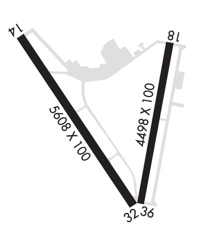
| Rwy | Rwy | |||||||
| 5608x100 | 5608' | 5608x100 | 5043' | |||||
| 4498x100 | 4498' | 4498x100 | 4498' | |||||
| Runway ID | Single Wheel | Double Wheel | Double Tandem Wheel | Dual Double Wheel |
| 14/32 | 45,000 | 80,000 | 140,000 | N/A |
| 18/36 | 45,000 | 80,000 | 140,000 | N/A |
| These numbers are Advisory and are not limits. The Airport Manager should have more accurate Weight Limits | ||||
 Airport Diagram might not be current. | |
| Facility Name: | ARANSAS COUNTY |
| City Name: | ROCKPORT |
| County: | ARANSAS |
| State abbrev: | TX |
| State Name: | TEXAS |
| Ownership: | PUBLICLY OWNED |
| Use: | OPEN TO THE PUBLIC |
| Owner's Name: | ARANSAS COUNTY |
| Address: | ARANSAS COUNTY COURTHOUSE, 301 N. LIVE OAK |
| ROCKPORT, TX 78382 | |
| Owner's Phone: | (361) 790-0100 |
| Manager's Name: | MIKE GEER |
| Address: | PO BOX 1270 |
| ROCKPORT, TX 78382 | |
| Phone: | 361-790-0141 |
| FAA Region: | SOUTHWEST |
| FAA Field Office: | TEX |
| Date | Sunrise | Sunset |
|---|---|---|
| 09/24/21 Friday | 7:17 | 19:23 |
| 09/25/21 Saturday | 7:18 | 19:21 |
| 09/26/21 Sunday | 7:18 | 19:20 |
| 09/27/21 Monday | 7:19 | 19:19 |
| 09/28/21 Tuesday | 7:19 | 19:18 |
| 09/29/21 Wednesday | 7:20 | 19:17 |
| 09/30/21 Thursday | 7:20 | 19:16 |
| 10/01/21 Friday | 7:21 | 19:14 |
| 10/02/21 Saturday | 7:21 | 19:13 |
| 10/03/21 Sunday | 7:22 | 19:12 |
| 10/04/21 Monday | 7:22 | 19:11 |
| 10/05/21 Tuesday | 7:23 | 19:10 |
| 10/06/21 Wednesday | 7:24 | 19:09 |
| 10/07/21 Thursday | 7:24 | 19:08 |
| Airport Attendance Schedule | 7 Days A Week 0730-1730 |
| Airport Status | OPERATIONAL (This Status can change at any time - please check NOTAMS) |
| Airport Lighting Schedule | MIRL RWY 14/32 & 18/36 PRESET LOW INTST. TO INCR INTST & ACTVT REIL 14 - CTAF. |
| Airport Storage Available | Tie Downs, Hanger |
| Extra Services Available | Flight Instruction, Aircraft Rental |
| Wind Indicator | YES - (lighted) |
| Control Tower | NO |
| CTAF Frequency | 123.050 |
| Unicom Frequency | 123.050 |
| Rotating Beacon Color | CLEAR-GREEN (Light Land Airport) |
| Segmented Circle | YES |
| Landing Fee | NO |
| Airport Inspected | STATE - performed by PRIVATE CONTRACT PERSONNEL |
| Inspection Date | 05/04/2020 |
| Type of Fuel Available | Grade 100LL, JET A (freeze point -40C) |
| Airframe Repair Service | MAJOR |
| Power Plant Repair Service | MAJOR |
| Latitude | N2805.2 |
| Longitude | W09702.6 (ESTIMATED) |
| Arpt Elevation | 23ft (SURVEYED) |
| Magnetic Variation | 06E |
| 4 miles N | of ROCKPORT |
| Traffic Pattern Altitude | |
| Sectional Chart | SAN ANTONIO |
| Operations (Reported) | Yearly | Avg. Daily |
|---|---|---|
| General Aviation Transient | 5000 | 14 |
| General Aviation Local | 20000 | 55 |
| Air Taxi | 5000 | 14 |
| Commerical | 0 | 0 |
| Commuter | 0 | 0 |
| Military | 75000 | 205 |
| Aircraft based on Field | |
|---|---|
| General Aviation Singles | 15 |
| General Aviation Multi | 5 |
| Jet Aircraft | 0 |
| General Aviation Helicopters | 1 |
| Military Aircraft | 0 |
| Gliders | 0 |
| Ultralights | 0 |
| FSS on field | NO |
| FSS tie-in | SAN ANGELO |
| FSS Phone | 1-800-WX-BRIEF |
| Who issues Notams | RKP |
| Notam D service at airport | YES |
| ARTCC Name | HOUSTON |
| Airport Certification | |
| Aircraft Rescue & Firefighting Index | None |
| Airport of Entry | No |
| Custom Landing Rights | No |
| Joint Civil/Military | No |
| Military Landing rights | YES |
| NATIONAL PLAN OF INTEGRATED AIRPORT SYSTEMS (NPIAS) |
| GRANT AGREEMENTS UNDER FAAP/ADAP/AIP |
| SURPLUS PROPERTY AGREEMENT UNDER REGULATION 16-WAA |
| ASSURANCES PURSUANT TO TITLE VI, CIVIL RIGHTS ACT OF 1964 |
| AGREEMENT UNDER DLAND OR DCLA HAS EXPIRED. |
| CAR RENTAL CALL 361-729-9922 |
Airport Communications & Frequencies:
| ||||||||||||||||
| Runway: 14 | Runway: 32 | ||
| Mag heading: | 139° | Mag heading: | 319° |
| Rwy Slope: | .16% Up | Rwy Slope: | -.16% Down |
| Approach: | Approach: | ||
| Pattern: | Left Traffic | Pattern: | Right Traffic |
| Markings: | NONPRECISION INSTRUMENT | Markings: | NONPRECISION INSTRUMENT |
| Marking Condition: | FAIR | Marking Condition: | FAIR |
| Arresting Dev: | Arresting Dev: | ||
| Lat & Long: | N2805.6 W09703.1 | Lat. & Long.: | N2804.8 W09702.5 |
| Elev: | 14.8 ft. MSL | Elev: | 23.8 ft. MSL |
| TCH: | 35 ft. AGL | TCH: | 25 ft. AGL |
| Visual Glide Path: | 3.00 degrees | Visual Glide Path: | 3.00 degrees |
| Displaced Threshold: | No | Displaced Threshold: | 565 feet |
| Touchdown Zone: | YES | Touchdown Zone: | YES |
| Touchdown Elev.: | 20.6 feet | Touchdown Elev.: | 23.8 feet |
| Visual Glide Slope: | 4-Light PAPI on LEFT side of Runway | Visual Glide Slope: | 4-Light PAPI on LEFT side of Runway |
| RVR Equipment: | RVR Equipment: | ||
| RVV Equipment: | NO | RVV Equipment: | NO |
| Approach Lights: | Approach Lights: | ||
| REIL: | YES | REIL: | NO |
| Centerline Lights: | NO | Centerline Lights: | NO |
| Touchdown lights: | NO | Touchdown lights: | NO |
| Runway Category: | Runway with a Non-precision Approach having visibility minimums greater than 3/4 mile | Runway Category: | Runway with a Non-precision Approach having visibility minimums greater than 3/4 mile |
| Declared Distances: | Declared Distances: | ||
| Obstructions: | BRUSH | Obstructions: | PLINE |
| Marked: | NOT Marked/Lighted | Marked: | NOT Marked/Lighted |
| Clearance slope: | 37:1 | Clearance slope: | 33:1; APCH SLOPE 50:1 FM DSPLCD THR. |
| Obstruction height: | 12 feet AGL | Obstruction height: | 23 feet AGL |
| Dist. from runway: | 645 feet | Dist. from runway: | 960 feet |
| Centerline offset: | Centerline offset: | 210 feet left of centerline | |
| Comments: | Comments: |
| Runway: 18 | Runway: 36 | ||
| Mag heading: | 184° | Mag heading: | 4° |
| Rwy Slope: | .07% Up | Rwy Slope: | -.07% Down |
| Approach: | Approach: | ||
| Pattern: | Right Traffic | Pattern: | Left Traffic |
| Markings: | NONPRECISION INSTRUMENT | Markings: | NONPRECISION INSTRUMENT |
| Marking Condition: | GOOD | Marking Condition: | GOOD |
| Arresting Dev: | Arresting Dev: | ||
| Lat & Long: | N2805.5 W09702.3 | Lat. & Long.: | N2804.8 W09702.5 |
| Elev: | 20.0 ft. MSL | Elev: | 23.1 ft. MSL |
| TCH: | 39 ft. AGL | TCH: | 42 ft. AGL |
| Visual Glide Path: | 3.00 degrees | Visual Glide Path: | 3.00 degrees |
| Displaced Threshold: | No | Displaced Threshold: | No |
| Touchdown Zone: | YES | Touchdown Zone: | YES |
| Touchdown Elev.: | 21.5 feet | Touchdown Elev.: | 23.2 feet |
| Visual Glide Slope: | 2-Light PAPI on LEFT side of Runway | Visual Glide Slope: | 2-Light PAPI on LEFT side of Runway |
| RVR Equipment: | RVR Equipment: | ||
| RVV Equipment: | NO | RVV Equipment: | NO |
| Approach Lights: | Approach Lights: | ||
| REIL: | NO | REIL: | NO |
| Centerline Lights: | NO | Centerline Lights: | NO |
| Touchdown lights: | NO | Touchdown lights: | NO |
| Runway Category: | Runway with a Non-precision Approach having visibility minimums greater than 3/4 mile | Runway Category: | Runway with a Non-precision Approach having visibility minimums greater than 3/4 mile |
| Declared Distances: | Declared Distances: | ||
| Obstructions: | TREES | Obstructions: | PLINE |
| Marked: | NOT Marked/Lighted | Marked: | LIGHTED |
| Clearance slope: | 22:1 | Clearance slope: | 17:1 |
| Obstruction height: | 20 feet AGL | Obstruction height: | 42 feet AGL |
| Dist. from runway: | 643 feet | Dist. from runway: | 922 feet |
| Centerline offset: | Centerline offset: | 220 feet right of centerline | |
| Comments: | Comments: |
Thanks for using FltPlan.com
all rights reserved © 1999-2021 by Flight Plan LLC