
| RIVERTON RGNL RIVERTON WY |
| |
| Lat: N 4303.9 Long: W 10827.6 Elev: 5516 Var: -10 Longest Runway: 8204 | ||
| AWOS: 121.42 CTAF: 122.8 | ||
| |||||||||||||||||||||||||||||||||||||||||||||||||||||||||||||
| |||||||||||||||||||||||||||||||||||||||||||||||||||||||||||||
| |||||||||||||||||||||||||||||||||||||||||||||||||||||||||||||
| Rwy | Rwy | |||||||
| 4800x75 | 4800' | 4800x75 | 4800' | |||||
| 8204x150 | 8204' | 8204x150 | 8204' | 110.50 - 284° | ||||
| Runway ID | Single Wheel | Double Wheel | Double Tandem Wheel | Dual Double Wheel |
| 01/19 | 30,000 | 50,000 | N/A | N/A |
| 10/28 | 85,000 | 110,000 | 165,000 | N/A |
| These numbers are Advisory and are not limits. The Airport Manager should have more accurate Weight Limits | ||||
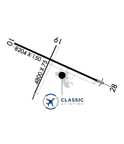 Airport Diagram might not be current. | |
| Facility Name: | CENTRAL WYOMING RGNL |
| City Name: | RIVERTON |
| County: | FREMONT |
| State abbrev: | WY |
| State Name: | WYOMING |
| Ownership: | PUBLICLY OWNED |
| Use: | OPEN TO THE PUBLIC |
| Owner's Name: | CITY OF RIVERTON |
| Address: | 816 N FEDERAL BLVD. |
| RIVERTON, WY 82501 | |
| Owner's Phone: | (307) 857-7780 |
| Manager's Name: | KYLE BUTTERFIELD |
| Address: | 816 NORTH FEDERAL BLVD |
| RIVERTON, WY 82501 | |
| Phone: | (307) 857-7704 |
| FAA Region: | NORTHWEST MOUNTAIN |
| FAA Field Office: | DEN |
| Date | Sunrise | Sunset |
|---|---|---|
| 09/24/21 Friday | 7:03 | 19:08 |
| 09/25/21 Saturday | 7:04 | 19:06 |
| 09/26/21 Sunday | 7:05 | 19:04 |
| 09/27/21 Monday | 7:06 | 19:02 |
| 09/28/21 Tuesday | 7:08 | 19:01 |
| 09/29/21 Wednesday | 7:09 | 18:59 |
| 09/30/21 Thursday | 7:10 | 18:57 |
| 10/01/21 Friday | 7:11 | 18:55 |
| 10/02/21 Saturday | 7:12 | 18:54 |
| 10/03/21 Sunday | 7:13 | 18:52 |
| 10/04/21 Monday | 7:14 | 18:50 |
| 10/05/21 Tuesday | 7:15 | 18:48 |
| 10/06/21 Wednesday | 7:17 | 18:47 |
| 10/07/21 Thursday | 7:18 | 18:45 |
| Airport Attendance Schedule | MON-FRI 0700-1700; FOR SVC AFTER HRS CALL 307-856-3599. |
| Airport Status | OPERATIONAL (This Status can change at any time - please check NOTAMS) |
| Airport Lighting Schedule | ACTVT HIRL RY 10/28; MIRL RY 01/19; REIL RY 01 & RY 19; AND REIL RY 10; MALSR RY 28 - CTAF. PAPI RY 01, RY 19, RY 10 & RY 28 OPER 24 HRS. |
| Airport Storage Available | Tie Downs, Hanger |
| Extra Services Available | Air Freight, Crop Dusting, Charter, Flight Instruction |
| Wind Indicator | YES - (lighted) |
| Control Tower | NO |
| CTAF Frequency | 122.800 |
| Unicom Frequency | 122.800 |
| Rotating Beacon Color | CLEAR-GREEN (Light Land Airport) |
| Segmented Circle | YES |
| Landing Fee | NO |
| Airport Inspected | FEDERAL - performed by FAA AIRPORTS FIELD PERSONNEL |
| Inspection Date | 07/24/2019 |
| Type of Fuel Available | Grade 100LL, JET A (freeze point -40C) |
| Airframe Repair Service | MAJOR |
| Power Plant Repair Service | MAJOR |
| Latitude | N4303.9 |
| Longitude | W10827.6 (ESTIMATED) |
| Arpt Elevation | 5515ft (SURVEYED) |
| Magnetic Variation | 10E |
| 3 miles NW | of RIVERTON |
| Traffic Pattern Altitude | |
| Sectional Chart | CHEYENNE |
| Operations (Reported) | Yearly | Avg. Daily |
|---|---|---|
| General Aviation Transient | 1974 | 5 |
| General Aviation Local | 1561 | 4 |
| Air Taxi | 1003 | 3 |
| Commerical | 0 | 0 |
| Commuter | 0 | 0 |
| Military | 9 | 0 |
| Aircraft based on Field | |
|---|---|
| General Aviation Singles | 32 |
| General Aviation Multi | 4 |
| Jet Aircraft | 0 |
| General Aviation Helicopters | 1 |
| Military Aircraft | 0 |
| Gliders | 0 |
| Ultralights | 0 |
| FSS on field | NO |
| FSS tie-in | CASPER |
| FSS Phone | 1-800-WX-BRIEF |
| Who issues Notams | RIW |
| Notam D service at airport | YES |
| ARTCC Name | SALT LAKE CITY |
| Airport Certification | AIRPORT RECEIVING SCHEDULED AIR CARRIER SERVICE FROM CARRIERS CERTIFICATED BY THE CIVIL AERONAUTICS BOARD; PPR FOR UNSKED OPNS WITH MORE THAN 30 PSGR SEATS CALL AMGR 307-857-7780/307-856-7063. |
| Aircraft Rescue & Firefighting Index | AIRPORT HAS A CERTIFICATE UNDER CFR PART 139 |
| Airport of Entry | No |
| Custom Landing Rights | No |
| Joint Civil/Military | No |
| Military Landing rights | YES |
| NATIONAL PLAN OF INTEGRATED AIRPORT SYSTEMS (NPIAS) |
| GRANT AGREEMENTS UNDER FAAP/ADAP/AIP |
| CONVEYANCE UNDER SCETION 16, FEDERAL AIRPORT ACT OF 1946 OR SECTION 23, AIRPORT AND AIRWAY DEVELOPMENT ACT OF 1970 |
| ASSURANCES PURSUANT TO TITLE VI, CIVIL RIGHTS ACT OF 1964 |
| GA ACFT NOT AUZD ON WEST RAMP. |
| MULTIPLE HOT AIR BALLOONS INVOF ARPT DURING JULY. |
| CONDS NOT MONITORED AT NGT AFT THE LAST ACR ARR TIL 0500L. SEE NOTAMS FOR THE MOST UP-TO-DATE CONDS AND UPDTS. |
| FOR CD IF UNA TO CTC ON FSS FREQ, CTC SALT LAKE ARTCC AT 801-320-2568. |
Airport Communications & Frequencies:
| |||||||||
| Runway: 01 | Runway: 19 | ||
| Mag heading: | 14° | Mag heading: | 194° |
| Rwy Slope: | .35% Up | Rwy Slope: | -.35% Down |
| Approach: | Approach: | ||
| Pattern: | Left Traffic | Pattern: | Left Traffic |
| Markings: | NONPRECISION INSTRUMENT | Markings: | NONPRECISION INSTRUMENT |
| Marking Condition: | GOOD | Marking Condition: | GOOD |
| Arresting Dev: | Arresting Dev: | ||
| Lat & Long: | N4303.4 W10827.9 | Lat. & Long.: | N4304.1 W10827.5 |
| Elev: | 5462.7 ft. MSL | Elev: | 5479.7 ft. MSL |
| TCH: | 43 ft. AGL | TCH: | 42 ft. AGL |
| Visual Glide Path: | 3.00 degrees | Visual Glide Path: | 3.00 degrees |
| Displaced Threshold: | No | Displaced Threshold: | No |
| Touchdown Zone: | YES | Touchdown Zone: | YES |
| Touchdown Elev.: | 5475.4 feet | Touchdown Elev.: | 5479.9 feet |
| Visual Glide Slope: | 2-Light PAPI on LEFT side of Runway | Visual Glide Slope: | 2-Light PAPI on LEFT side of Runway |
| RVR Equipment: | RVR Equipment: | ||
| RVV Equipment: | NO | RVV Equipment: | NO |
| Approach Lights: | Approach Lights: | ||
| REIL: | YES | REIL: | YES |
| Centerline Lights: | NO | Centerline Lights: | NO |
| Touchdown lights: | NO | Touchdown lights: | NO |
| Runway Category: | Runway with a Visual Approach | Runway Category: | Runway with a Visual Approach |
| Declared Distances: | TORA:4800' TODA:4800' ASDA:4800' LDA:4800' | Declared Distances: | TORA:4800' TODA:4800' ASDA:4800' LDA:4800' |
| Obstructions: | PLINE | Obstructions: | |
| Marked: | NOT Marked/Lighted | Marked: | |
| Clearance slope: | 50:1 | Clearance slope: | 50:1 |
| Obstruction height: | Obstruction height: | ||
| Dist. from runway: | Dist. from runway: | ||
| Centerline offset: | Centerline offset: | ||
| Comments: | Comments: |
| Runway: 10 | Runway: 28 | ||
| Mag heading: | 104° | Mag heading: | 284° |
| Rwy Slope: | -.89% Down | Rwy Slope: | .89% Up |
| Approach: | Approach: | ILS | |
| Pattern: | Left Traffic | Pattern: | Left Traffic |
| Markings: | PRECISION INSTRUMENT | Markings: | PRECISION INSTRUMENT |
| Marking Condition: | GOOD | Marking Condition: | GOOD |
| Arresting Dev: | Arresting Dev: | ||
| Lat & Long: | N4304.2 W10828.4 | Lat. & Long.: | N4303.6 W10826.7 |
| Elev: | 5515.9 ft. MSL | Elev: | 5442.9 ft. MSL |
| TCH: | 49 ft. AGL | TCH: | 50 ft. AGL |
| Visual Glide Path: | 3.00 degrees | Visual Glide Path: | 3.00 degrees |
| Displaced Threshold: | No | Displaced Threshold: | No |
| Touchdown Zone: | YES | Touchdown Zone: | YES |
| Touchdown Elev.: | 5515.9 feet | Touchdown Elev.: | 5459.3 feet |
| Visual Glide Slope: | 4-Light PAPI on LEFT side of Runway | Visual Glide Slope: | 4-Light PAPI on RIGHT side of Runway |
| RVR Equipment: | RVR Equipment: | ||
| RVV Equipment: | NO | RVV Equipment: | NO |
| Approach Lights: | Approach Lights: | MALSR - 1,400 foot medium intensity approach lighting system with runway alignment indicator lights | |
| REIL: | YES | REIL: | NO |
| Centerline Lights: | NO | Centerline Lights: | NO |
| Touchdown lights: | NO | Touchdown lights: | NO |
| Runway Category: | Runway with a Non-precision Approach having visibility minimums greater than 3/4 mile | Runway Category: | Precision Instrument Runway |
| Declared Distances: | TORA:8204' TODA:8204' ASDA:8204' LDA:8204' | Declared Distances: | TORA:8204' TODA:8204' ASDA:8204' LDA:8204' |
| Obstructions: | PLINE | Obstructions: | |
| Marked: | MARKED and LIGHTED | Marked: | |
| Clearance slope: | 28:1 | Clearance slope: | 50:1 |
| Obstruction height: | 133 feet AGL | Obstruction height: | |
| Dist. from runway: | 3950 feet | Dist. from runway: | |
| Centerline offset: | Centerline offset: | ||
| Comments: | Comments: |
Thanks for using FltPlan.com
all rights reserved © 1999-2021 by Flight Plan LLC

