| RICHMOND MUNI RICHMOND IN |
| |
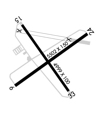
| Lat: N 3945.4 Long: W 08450.6 Elev: 1140 Var: +03 Longest Runway: 5502 | ||
| Clr Del: 133.55 AWOS: 121.22 CTAF: 122.7 | ||
| ||||||||||||||||||||||||||||||||||||||||||||||||||||||||||||||||||||
| ||||||||||||||||||||||||||||||||||||||||||||||||||||||||||||||||||||
| ||||||||||||||||||||||||||||||||||||||||||||||||||||||||||||||||||||
| Rwy | Rwy | |||||||
| 5502x150 | 5202' | 5502x150 | 5502' | 111.35 - 238° | ||||
| 4999x100 | 4999' | 4999x100 | 4999' | |||||
| Runway ID | Single Wheel | Double Wheel | Double Tandem Wheel | Dual Double Wheel |
| 06/24 | 30,000 | 40,000 | 60,000 | N/A |
| 15/33 | 30,000 | 40,000 | 60,000 | N/A |
| These numbers are Advisory and are not limits. The Airport Manager should have more accurate Weight Limits | ||||
 Airport Diagram might not be current. | |
| Facility Name: | RICHMOND MUNI |
| City Name: | RICHMOND |
| County: | WAYNE |
| State abbrev: | IN |
| State Name: | INDIANA |
| Ownership: | PUBLICLY OWNED |
| Use: | OPEN TO THE PUBLIC |
| Owner's Name: | RICHMOND BOAC |
| Address: | 5169 SR 227 S. |
| RICHMOND, IN 47375 | |
| Owner's Phone: | 765-983-7296 |
| Manager's Name: | RODNEY MAYSE |
| Address: | 5169 SR 227 S. |
| RICHMOND, IN 47374 | |
| Phone: | 765-983-7296; AFT HR 765-993-4139. |
| FAA Region: | GREAT LAKES |
| FAA Field Office: | CHI |
| Date | Sunrise | Sunset |
|---|---|---|
| 06/08/26 Monday | 6:11 | 21:06 |
| 06/09/26 Tuesday | 6:11 | 21:06 |
| 06/10/26 Wednesday | 6:11 | 21:07 |
| 06/11/26 Thursday | 6:11 | 21:07 |
| 06/12/26 Friday | 6:11 | 21:08 |
| 06/13/26 Saturday | 6:11 | 21:08 |
| 06/14/26 Sunday | 6:11 | 21:09 |
| 06/15/26 Monday | 6:11 | 21:09 |
| 06/16/26 Tuesday | 6:11 | 21:09 |
| 06/17/26 Wednesday | 6:11 | 21:10 |
| 06/18/26 Thursday | 6:11 | 21:10 |
| 06/19/26 Friday | 6:11 | 21:10 |
| 06/20/26 Saturday | 6:11 | 21:11 |
| 06/21/26 Sunday | 6:11 | 21:11 |
| Airport Attendance Schedule | 7 Days A Week 0800-1745 |
| Airport Status | OPERATIONAL (This Status can change at any time - please check NOTAMS) |
| Airport Lighting Schedule | ACTVT REIL RWY 06; PAPI RWY 06 & 24; MIRL RWY 06/24 & RWY 15/33 - CTAF. |
| Airport Storage Available | Tie Downs, Hanger |
| Extra Services Available | NONE |
| Wind Indicator | YES - (lighted) |
| Control Tower | NO |
| CTAF Frequency | 122.700 |
| Unicom Frequency | 122.700 |
| Rotating Beacon Color | WG |
| Segmented Circle | NO |
| Landing Fee | NO |
| Airport Inspected | STATE - performed by STATE AERONAUTICAL PERSONNEL |
| Inspection Date | 02/12/2025 |
| Type of Fuel Available | Grade 100LL, JET A (freeze point -40C) |
| Airframe Repair Service | MINOR |
| Power Plant Repair Service | MINOR |
| Latitude | N3945.4 |
| Longitude | W08450.6 (ESTIMATED) |
| Arpt Elevation | 1139ft (SURVEYED) |
| Magnetic Variation | 03W |
| 5 miles SE | of RICHMOND |
| Traffic Pattern Altitude | |
| Sectional Chart | CINCINNATI |
| Operations (Reported) | Yearly | Avg. Daily |
|---|---|---|
| General Aviation Transient | 0 | 0 |
| General Aviation Local | 0 | 0 |
| Air Taxi | 0 | 0 |
| Commerical | 0 | 0 |
| Commuter | 0 | 0 |
| Military | 0 | 0 |
| Aircraft based on Field | |
|---|---|
| General Aviation Singles | 0 |
| General Aviation Multi | 0 |
| Jet Aircraft | 0 |
| General Aviation Helicopters | 0 |
| Military Aircraft | 0 |
| Gliders | 0 |
| Ultralights | 0 |
| FSS on field | NO |
| FSS tie-in | TERRE HAUTE |
| FSS Phone | 1-800-WX-BRIEF |
| Who issues Notams | HUF |
| Notam D service at airport | YES |
| ARTCC Name | INDIANAPOLIS |
| Airport Certification | |
| Aircraft Rescue & Firefighting Index | None |
| Airport of Entry | No |
| Custom Landing Rights | No |
| Joint Civil/Military | No |
| Military Landing rights | YES |
| NATIONAL PLAN OF INTEGRATED AIRPORT SYSTEMS (NPIAS) |
| GRANT AGREEMENTS UNDER FAAP/ADAP/AIP |
| ASSURANCES PURSUANT TO TITLE VI, CIVIL RIGHTS ACT OF 1964 |
| AGREEMENT UNDER DLAND OR DCLA HAS EXPIRED. |
Airport Communications & Frequencies:
| ||||||||||||||||
| Runway: 06 | Runway: 24 | ||
| Mag heading: | 58° | Mag heading: | 238° |
| Rwy Slope: | .06% Up | Rwy Slope: | -.06% Down |
| Approach: | Approach: | LOC/GS | |
| Pattern: | Left Traffic | Pattern: | Left Traffic |
| Markings: | PRECISION INSTRUMENT | Markings: | PRECISION INSTRUMENT |
| Marking Condition: | GOOD | Marking Condition: | GOOD |
| Arresting Dev: | Arresting Dev: | ||
| Lat & Long: | N3945.1 W08451.0 | Lat. & Long.: | N3945.6 W08450.0 |
| Elev: | 1134.7 ft. MSL | Elev: | 1138.2 ft. MSL |
| TCH: | 26 ft. AGL | TCH: | 47 ft. AGL |
| Visual Glide Path: | 3.00 degrees | Visual Glide Path: | 3.00 degrees |
| Displaced Threshold: | 300 feet | Displaced Threshold: | No |
| Touchdown Zone: | YES | Touchdown Zone: | YES |
| Touchdown Elev.: | 1136.2 feet | Touchdown Elev.: | 1139.3 feet |
| Visual Glide Slope: | 4-Light PAPI on LEFT side of Runway | Visual Glide Slope: | 4-Light PAPI on LEFT side of Runway |
| RVR Equipment: | RVR Equipment: | ||
| RVV Equipment: | NO | RVV Equipment: | NO |
| Approach Lights: | Approach Lights: | ||
| REIL: | YES | REIL: | NO |
| Centerline Lights: | NO | Centerline Lights: | NO |
| Touchdown lights: | NO | Touchdown lights: | NO |
| Runway Category: | Runway with a Non-precision Approach having visibility minimums greater than 3/4 mile | Runway Category: | Precision Instrument Runway |
| Declared Distances: | TORA:5500' TODA:5500' ASDA:5500' LDA:5200' | Declared Distances: | TORA:5500' TODA:5500' ASDA:5500' LDA:5500' |
| Obstructions: | ROAD | Obstructions: | TREES |
| Marked: | NOT Marked/Lighted | Marked: | NOT Marked/Lighted |
| Clearance slope: | 6:1; APCH RATIO 34:1 TO DTHR. | Clearance slope: | 21:1; APCH RATIO 24:1 TO THR. |
| Obstruction height: | 18 feet AGL | Obstruction height: | 72 feet AGL |
| Dist. from runway: | 320 feet | Dist. from runway: | 1740 feet |
| Centerline offset: | 510 left of centerline | Centerline offset: | 730 feet right of centerline |
| Comments: | Comments: |
| Runway: 15 | Runway: 33 | ||
| Mag heading: | 148° | Mag heading: | 328° |
| Rwy Slope: | .26% Up | Rwy Slope: | -.26% Down |
| Approach: | Approach: | ||
| Pattern: | Left Traffic | Pattern: | Left Traffic |
| Markings: | NONPRECISION INSTRUMENT | Markings: | NONPRECISION INSTRUMENT |
| Marking Condition: | GOOD | Marking Condition: | GOOD |
| Arresting Dev: | Arresting Dev: | ||
| Lat & Long: | N3945.7 W08450.9 | Lat. & Long.: | N3945.0 W08450.3 |
| Elev: | 1126.7 ft. MSL | Elev: | 1139.8 ft. MSL |
| TCH: | TCH: | ||
| Visual Glide Path: | Visual Glide Path: | ||
| Displaced Threshold: | No | Displaced Threshold: | No |
| Touchdown Zone: | YES | Touchdown Zone: | YES |
| Touchdown Elev.: | 1136.1 feet | Touchdown Elev.: | 1139.8 feet |
| Visual Glide Slope: | Visual Glide Slope: | ||
| RVR Equipment: | RVR Equipment: | ||
| RVV Equipment: | NO | RVV Equipment: | NO |
| Approach Lights: | Approach Lights: | ||
| REIL: | NO | REIL: | NO |
| Centerline Lights: | NO | Centerline Lights: | NO |
| Touchdown lights: | NO | Touchdown lights: | NO |
| Runway Category: | Runway with a Visual Approach | Runway Category: | Runway with a Non-precision Approach having visibility minimums greater than 3/4 mile |
| Declared Distances: | Declared Distances: | ||
| Obstructions: | Obstructions: | TREES | |
| Marked: | Marked: | NOT Marked/Lighted | |
| Clearance slope: | 20:1 | Clearance slope: | 35:1 |
| Obstruction height: | Obstruction height: | 66 feet AGL | |
| Dist. from runway: | Dist. from runway: | 2550 feet | |
| Centerline offset: | Centerline offset: | 15 feet left of centerline | |
| Comments: | 10 FT CROPS 105 FT L OF RWY END CNTRLN. | Comments: | 10 FT CROPS 100 FT L & R OF RWY END CNTRLN. |
Thanks for using FltPlan.com
all rights reserved © 1999-2026 by Flight Plan LLC