
| REID-HILLVIEW OF SANTA CLARA SAN JOSE CA |
| |
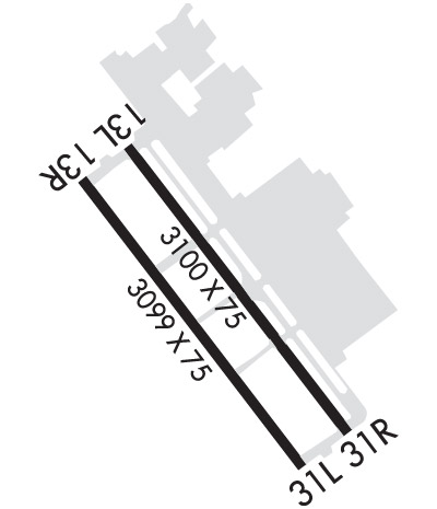
| Lat: N 3720.0 Long: W 12149.2 Elev: 135 Var: -16 Longest Runway: 3100 | ||
| Dept. ATIS: 125.2 Arr. ATIS: 125.2 Ground: 121.65 Tower: 119.8/126.1 | ||
| ||||||||||||||||||||||||||||||||||||||||||||
| ||||||||||||||||||||||||||||||||||||||||||||
| ||||||||||||||||||||||||||||||||||||||||||||
| ||||||||||||||||||||||||||||||||||||||||||||
| ||||||||||||||||||||||||||||||||||||||||||||
| ||||||||||||||||||||||||||||||||||||||||||||
| ||||||||||||||||||||||||||||||||||||||||||||
| Rwy | Rwy | |||||||
| 3100x75 | 2601' | 3100x75 | 2690' | |||||
| 3099x75 | 2600' | 3099x75 | 2690' | |||||
| Runway ID | Single Wheel | Double Wheel | Double Tandem Wheel | Dual Double Wheel |
| 13L/31R | 17,000 | N/A | N/A | N/A |
| 13R/31L | 17,000 | N/A | N/A | N/A |
| These numbers are Advisory and are not limits. The Airport Manager should have more accurate Weight Limits | ||||
 Airport Diagram might not be current. | |
| Facility Name: | REID-HILLVIEW OF SANTA CLARA COUNTY |
| City Name: | SAN JOSE |
| County: | SANTA CLARA |
| State abbrev: | CA |
| State Name: | CALIFORNIA |
| Ownership: | PUBLICLY OWNED |
| Use: | OPEN TO THE PUBLIC |
| Owner's Name: | COUNTY OF SANTA CLARA |
| Address: | 2500 CUNNINGHAM AVE |
| SAN JOSE, CA 95148 | |
| Owner's Phone: | 408-929-7700; DIRECTOR OF AIRPORTS, ERIC PETERSON |
| Manager's Name: | FEMI ODUNBAKU |
| Address: | 2500 CUNNINGHAM AVE. |
| SAN JOSE, CA 95148 | |
| Phone: | 408-918-7707 |
| FAA Region: | WESTERN-PACIFIC |
| FAA Field Office: | SFO |
| Date | Sunrise | Sunset |
|---|---|---|
| 09/24/21 Friday | 6:57 | 19:01 |
| 09/25/21 Saturday | 6:57 | 19:00 |
| 09/26/21 Sunday | 6:58 | 18:58 |
| 09/27/21 Monday | 6:59 | 18:57 |
| 09/28/21 Tuesday | 7:00 | 18:55 |
| 09/29/21 Wednesday | 7:01 | 18:54 |
| 09/30/21 Thursday | 7:02 | 18:52 |
| 10/01/21 Friday | 7:03 | 18:51 |
| 10/02/21 Saturday | 7:03 | 18:49 |
| 10/03/21 Sunday | 7:04 | 18:48 |
| 10/04/21 Monday | 7:05 | 18:46 |
| 10/05/21 Tuesday | 7:06 | 18:45 |
| 10/06/21 Wednesday | 7:07 | 18:43 |
| 10/07/21 Thursday | 7:08 | 18:42 |
| Airport Attendance Schedule | 7 Days A Week 0800-1800 |
| Airport Status | OPERATIONAL (This Status can change at any time - please check NOTAMS) |
| Airport Lighting Schedule | WHEN ATCT CLSD ACTVT REIL RWYS 13L & 31R; MIRL RWY 13L/31R - CTAF. PAPI RWYS 13L, 31R & 31L OPR CONSLY. |
| Airport Storage Available | Tie Downs |
| Extra Services Available | Flight Instruction, Aircraft Rental, Aircraft Sales |
| Wind Indicator | YES - (lighted) |
| Control Tower | YES |
| CTAF Frequency | 119.800 |
| Unicom Frequency | 122.950 |
| Rotating Beacon Color | CLEAR-GREEN (Light Land Airport) |
| Segmented Circle | YES |
| Landing Fee | NO |
| Airport Inspected | STATE - performed by STATE AERONAUTICAL PERSONNEL |
| Inspection Date | 12/03/2020 |
| Type of Fuel Available | Grade 100LL, JET A (freeze point -40C); -10SELF-FUELING AVIALABLE 24/7. |
| Airframe Repair Service | MAJOR |
| Power Plant Repair Service | MAJOR |
| Latitude | N3720.0 |
| Longitude | W12149.2 (ESTIMATED) |
| Arpt Elevation | 135ft (SURVEYED) |
| Magnetic Variation | 16E |
| 4 miles SE | of SAN JOSE |
| Traffic Pattern Altitude | |
| Sectional Chart | SAN FRANCISCO |
| Operations (Reported) | Yearly | Avg. Daily |
|---|---|---|
| General Aviation Transient | 86135 | 236 |
| General Aviation Local | 123179 | 337 |
| Air Taxi | 0 | 0 |
| Commerical | 0 | 0 |
| Commuter | 0 | 0 |
| Military | 0 | 0 |
| Aircraft based on Field | |
|---|---|
| General Aviation Singles | 115 |
| General Aviation Multi | 6 |
| Jet Aircraft | 0 |
| General Aviation Helicopters | 2 |
| Military Aircraft | 0 |
| Gliders | 1 |
| Ultralights | 0 |
| FSS on field | NO |
| FSS tie-in | OAKLAND |
| FSS Phone | 1-800-WX-BRIEF |
| Who issues Notams | RHV |
| Notam D service at airport | YES |
| ARTCC Name | OAKLAND |
| Airport Certification | |
| Aircraft Rescue & Firefighting Index | None |
| Airport of Entry | No |
| Custom Landing Rights | No |
| Joint Civil/Military | No |
| Military Landing rights | YES |
| NATIONAL PLAN OF INTEGRATED AIRPORT SYSTEMS (NPIAS) |
| GRANT AGREEMENTS UNDER FAAP/ADAP/AIP |
| ASSURANCES PURSUANT TO TITLE VI, CIVIL RIGHTS ACT OF 1964 |
| THIS AIRPORT HAS BEEN SURVEYED BY THE NATIONAL GEODETIC SURVEY. |
| RY 31R CALM WIND RY WHEN ATCT CLSD. |
| NO TURNS BLO 500' WHEN LEAVING PATTERN EXCEPT RWY 31R DEPARTURES - AS SOON AS PRACTICABLE AFTER DEPARTURE MAKE A SLIGHT RIGHT TURN TO AVOID SCHOOL ONE HALF MILE OFF DEPARTURE END. |
| NO TOUCH & GO LNDGS BTN 2100-0700. |
| NO SIMULATED EMERGENCIES IN ARPT TFC AREA. |
| BIRDS ON AND INVOF ARPT. |
| BE ALERT ALL PILOTS - DO NOT CONFUSE ILLUMINATION FROM STREET LGTS NORTH-EAST OF AND PARALLEL TO RHV RYS THAT COULD BE MISTAKEN FOR RY LGTS. ENSURE PROPER ACTVTN OF PILOT CTLD ARPT SFC LGTG. |
| FOR CD WHEN ATCT IS CLSD CTC NORCAL APCH AT 916-361-3748. |
| RWY 13R/ 31LRWY 13R/31L UNLGTD. |
| RWY 31 +6 FT FENCE 150 FT FROM THR; RY 31R & 31L ROAD EDGE 155 FT FROM THR. |
Airport Communications & Frequencies:
| |||||||||||||||||||||||||||||||||||
| Runway: 13L | Runway: 31R | ||
| Mag heading: | 127° | Mag heading: | 307° |
| Rwy Slope: | .38% Up | Rwy Slope: | -.38% Down |
| Approach: | Approach: | ||
| Pattern: | Left Traffic | Pattern: | Right Traffic |
| Markings: | NONPRECISION INSTRUMENT | Markings: | NONPRECISION INSTRUMENT |
| Marking Condition: | GOOD | Marking Condition: | GOOD |
| Arresting Dev: | Arresting Dev: | ||
| Lat & Long: | N3720.2 W12149.4 | Lat. & Long.: | N3719.8 W12149.0 |
| Elev: | 123.6 ft. MSL | Elev: | 135.4 ft. MSL |
| TCH: | 45 ft. AGL | TCH: | 45 ft. AGL |
| Visual Glide Path: | 4.00 degrees | Visual Glide Path: | 4.00 degrees |
| Displaced Threshold: | 499 feet | Displaced Threshold: | 410 feet |
| Touchdown Zone: | YES | Touchdown Zone: | YES |
| Touchdown Elev.: | 135.4 feet | Touchdown Elev.: | 133.3 feet |
| Visual Glide Slope: | 4-Light PAPI on RIGHT side of Runway | Visual Glide Slope: | 4-Light PAPI on LEFT side of Runway |
| RVR Equipment: | RVR Equipment: | ||
| RVV Equipment: | NO | RVV Equipment: | NO |
| Approach Lights: | Approach Lights: | ||
| REIL: | YES | REIL: | YES |
| Centerline Lights: | NO | Centerline Lights: | NO |
| Touchdown lights: | NO | Touchdown lights: | NO |
| Runway Category: | Runway with a Non-precision Approach | Runway Category: | Runway with a Non-precision Approach |
| Declared Distances: | Declared Distances: | ||
| Obstructions: | TREE | Obstructions: | ROAD |
| Marked: | NOT Marked/Lighted | Marked: | NOT Marked/Lighted |
| Clearance slope: | 15:1; RY 13L APCH RATIO TO DSPLCD THLD 30:1. | Clearance slope: | RY 31R APCH RATIO TO DSPLCD THLD 34:1. |
| Obstruction height: | 47 feet AGL | Obstruction height: | 16 feet AGL |
| Dist. from runway: | 920 feet | Dist. from runway: | 200 feet |
| Centerline offset: | 205 left of centerline | Centerline offset: | |
| Comments: | Comments: | +6 FT FENCE 150 FT FROM THR; RY 31R & 31L ROAD EDGE 155 FT FROM THR. |
| Runway: 13R | Runway: 31L | ||
| Mag heading: | 127° | Mag heading: | 307° |
| Rwy Slope: | .36% Up | Rwy Slope: | -.36% Down |
| Approach: | Approach: | ||
| Pattern: | Right Traffic | Pattern: | Left Traffic |
| Markings: | NONPRECISION INSTRUMENT | Markings: | NONPRECISION INSTRUMENT |
| Marking Condition: | GOOD | Marking Condition: | GOOD |
| Arresting Dev: | Arresting Dev: | ||
| Lat & Long: | N3720.2 W12149.4 | Lat. & Long.: | N3719.8 W12149.0 |
| Elev: | 122.8 ft. MSL | Elev: | 133.9 ft. MSL |
| TCH: | TCH: | 45 ft. AGL | |
| Visual Glide Path: | Visual Glide Path: | 4.00 degrees | |
| Displaced Threshold: | 499 feet | Displaced Threshold: | 409 feet |
| Touchdown Zone: | YES | Touchdown Zone: | YES |
| Touchdown Elev.: | 133.9 feet | Touchdown Elev.: | 130.9 feet |
| Visual Glide Slope: | Visual Glide Slope: | 4-Light PAPI on LEFT side of Runway | |
| RVR Equipment: | RVR Equipment: | ||
| RVV Equipment: | NO | RVV Equipment: | NO |
| Approach Lights: | Approach Lights: | ||
| REIL: | NO | REIL: | NO |
| Centerline Lights: | NO | Centerline Lights: | NO |
| Touchdown lights: | NO | Touchdown lights: | NO |
| Runway Category: | Runway with a Visual Approach | Runway Category: | Runway with a Non-precision Approach |
| Declared Distances: | Declared Distances: | ||
| Obstructions: | TREE | Obstructions: | ROAD |
| Marked: | NOT Marked/Lighted | Marked: | NOT Marked/Lighted |
| Clearance slope: | 14:1; RY 13R APCH RATIO TO DSPLCD THLD 27:1. | Clearance slope: | APCH RATIO TO DSPLCD THR 33:1 |
| Obstruction height: | 55 feet AGL | Obstruction height: | 18 feet AGL |
| Dist. from runway: | 1016 feet | Dist. from runway: | 200 feet |
| Centerline offset: | 75 left of centerline | Centerline offset: | |
| Comments: | Comments: |
Thanks for using FltPlan.com
all rights reserved © 1999-2021 by Flight Plan LLC
