
| WESTERN CAROLINA RGNL ANDREWS NC |
| |
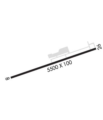
| Lat: N 3511.7 Long: W 08351.8 Elev: 1699 Var: +04 Longest Runway: 5500 | ||
| AWOS: 119.67 CTAF: 122.8 | ||
| ||||||||||||||||||||||||||||||||||||||||||||
| ||||||||||||||||||||||||||||||||||||||||||||
| ||||||||||||||||||||||||||||||||||||||||||||
| Rwy | Rwy | |||||||
| 5500x100 | 5285' | 5500x100 | 5500' | |||||
| Runway ID | Single Wheel | Double Wheel | Double Tandem Wheel | Dual Double Wheel |
| 08/26 | 25,000 | 45,000 | N/A | N/A |
| These numbers are Advisory and are not limits. The Airport Manager should have more accurate Weight Limits | ||||
 Airport Diagram might not be current. | |
| Facility Name: | WESTERN CAROLINA RGNL |
| City Name: | ANDREWS |
| County: | CHEROKEE |
| State abbrev: | NC |
| State Name: | NORTH CAROLINA |
| Ownership: | PUBLICLY OWNED |
| Use: | OPEN TO THE PUBLIC |
| Owner's Name: | CHEROKEE COUNTY |
| Address: | 75 PEACHTREE STREET |
| MURPHY, NC 28906 | |
| Owner's Phone: | 828-835-8578 |
| Manager's Name: | CHRIS WILLIAMS |
| Address: | 5840 AIRPORT ROAD |
| ANDREWS, NC 28901 | |
| Phone: | 828-321-5114 |
| FAA Region: | SOUTHERN |
| FAA Field Office: | MEM |

| Date | Sunrise | Sunset |
|---|---|---|
| 06/07/26 Sunday | 6:21 | 20:48 |
| 06/08/26 Monday | 6:21 | 20:48 |
| 06/09/26 Tuesday | 6:21 | 20:49 |
| 06/10/26 Wednesday | 6:20 | 20:49 |
| 06/11/26 Thursday | 6:20 | 20:50 |
| 06/12/26 Friday | 6:20 | 20:50 |
| 06/13/26 Saturday | 6:20 | 20:51 |
| 06/14/26 Sunday | 6:20 | 20:51 |
| 06/15/26 Monday | 6:20 | 20:51 |
| 06/16/26 Tuesday | 6:20 | 20:52 |
| 06/17/26 Wednesday | 6:21 | 20:52 |
| 06/18/26 Thursday | 6:21 | 20:52 |
| 06/19/26 Friday | 6:21 | 20:53 |
| 06/20/26 Saturday | 6:21 | 20:53 |
| Airport Attendance Schedule | MON-SAT 0900-1700, SUN 1200-1700; UNATNDD THANKSGIVING, CHRISTMAS AND NEW YEARS DAY. |
| Airport Status | OPERATIONAL (This Status can change at any time - please check NOTAMS) |
| Airport Lighting Schedule | MIRL RWY 08/26 OPR SS-SR; TO INCR INTST - CTAF. ACTVT REIL RWY 08 - CTAF. PAPI RWY 08 & 26 OPER CONSLY, OTR TIMES - CTAF. |
| Airport Storage Available | Tie Downs, Hanger |
| Extra Services Available | Charter, Flight Instruction, Aircraft Rental |
| Wind Indicator | YES - (lighted) |
| Control Tower | NO |
| CTAF Frequency | 122.800 |
| Unicom Frequency | 122.800 |
| Rotating Beacon Color | WG; LCTD 0.5 MI NORTH OF WEST END OF RWY 08/26. |
| Segmented Circle | YES |
| Landing Fee | NO |
| Airport Inspected | STATE - performed by STATE AERONAUTICAL PERSONNEL |
| Inspection Date | 07/26/2023 |
| Type of Fuel Available | Grade 100LL, JET A (freeze point -40C), JET A-1 (icing inhibitor, freeze point -50C); -10FUEL AVBL 24 HR WITH CREDIT CARD. |
| Airframe Repair Service | MAJOR |
| Power Plant Repair Service | MAJOR |
| Latitude | N3511.7 |
| Longitude | W08351.8 (ESTIMATED) |
| Arpt Elevation | 1698ft (SURVEYED) |
| Magnetic Variation | 04W |
| 2 miles W | of ANDREWS |
| Traffic Pattern Altitude | |
| Sectional Chart | ATLANTA |
| Operations (Reported) | Yearly | Avg. Daily |
|---|---|---|
| General Aviation Transient | 0 | 0 |
| General Aviation Local | 0 | 0 |
| Air Taxi | 0 | 0 |
| Commerical | 0 | 0 |
| Commuter | 0 | 0 |
| Military | 0 | 0 |
| Aircraft based on Field | |
|---|---|
| General Aviation Singles | 0 |
| General Aviation Multi | 0 |
| Jet Aircraft | 0 |
| General Aviation Helicopters | 0 |
| Military Aircraft | 0 |
| Gliders | 0 |
| Ultralights | 0 |
| FSS on field | NO |
| FSS tie-in | RALEIGH |
| FSS Phone | 1-800-WX-BRIEF |
| Who issues Notams | RHP |
| Notam D service at airport | YES |
| ARTCC Name | ATLANTA |
| Airport Certification | |
| Aircraft Rescue & Firefighting Index | None |
| Airport of Entry | No |
| Custom Landing Rights | No |
| Joint Civil/Military | No |
| Military Landing rights | YES |
| NATIONAL PLAN OF INTEGRATED AIRPORT SYSTEMS (NPIAS) |
| GRANT AGREEMENTS UNDER FAAP/ADAP/AIP |
| ASSURANCES PURSUANT TO TITLE VI, CIVIL RIGHTS ACT OF 1964 |
| LOW FLYING MIL JET ACFT OVERFLY ARPT. |
| TWY UNLGTD. |
| 4-5 FT DITCH 75 FT FROM RWY CNTRLN ON BOTH SIDES. |
| RWY 08 RR 390 FT RIGHT OF CNTRLN 260 FT FM THLD. |
| ARPT SRNDD BY HIGH TRRN. |
| RWY 08, 8 FT DROP-OFF, 108 FT FM THLD BOTH SIDES IN RWY SAFETY AREA. |
| COLD TEMPERATURE AIRPORT. ALTITUDE CORRECTION REQUIRED AT OR BELOW -4C. |
| FOR CD CTC ATLANTA ARTCC AT 770-210-7692. |
| LIVESTOCK PASTURED INVOF ARPT. |
Airport Communications & Frequencies:
| |||||||||
| Runway: 08 | Runway: 26 | ||
| Mag heading: | 75° | Mag heading: | 255° |
| Rwy Slope: | .29% Up | Rwy Slope: | -.29% Down |
| Approach: | Approach: | ||
| Pattern: | Right Traffic | Pattern: | Left Traffic |
| Markings: | NONPRECISION INSTRUMENT | Markings: | NONPRECISION INSTRUMENT |
| Marking Condition: | GOOD | Marking Condition: | GOOD |
| Arresting Dev: | Arresting Dev: | ||
| Lat & Long: | N3511.6 W08352.3 | Lat. & Long.: | N3511.9 W08351.3 |
| Elev: | 1682.0 ft. MSL | Elev: | 1698.1 ft. MSL |
| TCH: | 24 ft. AGL | TCH: | 44 ft. AGL |
| Visual Glide Path: | 3.50 degrees | Visual Glide Path: | 4.00 degrees |
| Displaced Threshold: | 215 feet | Displaced Threshold: | No |
| Touchdown Zone: | YES | Touchdown Zone: | YES |
| Touchdown Elev.: | 1682.3 feet | Touchdown Elev.: | 1698.1 feet |
| Visual Glide Slope: | 2-Light PAPI on LEFT side of Runway; PAPI UNUSBL BYD 6 DEG LEFT AND 8 DEG RIGHT OF CNTRLN DUE TO TRRN. | Visual Glide Slope: | 2-Light PAPI on LEFT side of Runway; PAPI UNUSBL BYD 6 DEG RIGHT OF CNTRLN DUE TO TRRN; UNUSBL BYD 2.5 NM FM THR DUE TO TRRN. |
| RVR Equipment: | RVR Equipment: | ||
| RVV Equipment: | NO | RVV Equipment: | NO |
| Approach Lights: | Approach Lights: | ||
| REIL: | YES | REIL: | NO |
| Centerline Lights: | NO | Centerline Lights: | NO |
| Touchdown lights: | NO | Touchdown lights: | NO |
| Runway Category: | Runway with a Non-precision Approach having visibility minimums greater than 3/4 mile | Runway Category: | Runway with a Visual Approach |
| Declared Distances: | Declared Distances: | ||
| Obstructions: | RR | Obstructions: | TREES |
| Marked: | NOT Marked/Lighted | Marked: | NOT Marked/Lighted |
| Clearance slope: | APCH RATIO 19:1 AT DSPLCD THLD DUE TO RR. | Clearance slope: | 18:1 |
| Obstruction height: | 20 feet AGL | Obstruction height: | 51 feet AGL |
| Dist. from runway: | 216 feet | Dist. from runway: | 1144 feet |
| Centerline offset: | 246 right of centerline | Centerline offset: | 92 feet left of centerline |
| Comments: | HAS 5 FT CROPS 0-200 FT FM END OFFSET 150 FT RIGHT OF CNTRLN AND 2 FT BRUSH 189 FT FM END OFFSET 65 FT LEFT OF CNTRLN. | Comments: | 3 FT BERM 20 FT FM THLD OFFSET 81 FT RIGHT OF CNTRLN. |
Thanks for using FltPlan.com
all rights reserved © 1999-2026 by Flight Plan LLC