
| RHINELANDER-ONEIDA COUNTY RHINELANDER WI |
| |
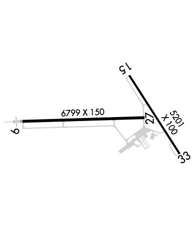
| Lat: N 4537.9 Long: W 08928.0 Elev: 1623 Var: +03 Longest Runway: 6800 | ||
| AWOS: 126.82 CTAF: 123.0 | ||
| ||||||||||||||||||||||||||||||||||||||||||||
| ||||||||||||||||||||||||||||||||||||||||||||
| ||||||||||||||||||||||||||||||||||||||||||||
| Rwy | Rwy | |||||||
| 6800x150 | 6800' | 111.30 - 091° | 6800x150 | 6800' | ||||
| 5201x100 | 5201' | 5201x100 | 5201' | |||||
| Runway ID | Single Wheel | Double Wheel | Double Tandem Wheel | Dual Double Wheel |
| 09/27 | 100,000 | 130,000 | 230,000 | N/A |
| 15/33 | 90,000 | 130,000 | 230,000 | N/A |
| These numbers are Advisory and are not limits. The Airport Manager should have more accurate Weight Limits | ||||
 Airport Diagram might not be current. | |
| Facility Name: | RHINELANDER/ONEIDA COUNTY |
| City Name: | RHINELANDER |
| County: | ONEIDA |
| State abbrev: | WI |
| State Name: | WISCONSIN |
| Ownership: | PUBLICLY OWNED |
| Use: | OPEN TO THE PUBLIC |
| Owner's Name: | RHINELANDER & ONEIDA CO. |
| Address: | 3375 AIRPORT ROAD |
| RHINELANDER, WI 54501 | |
| Owner's Phone: | 715-365-3416 |
| Manager's Name: | MATTHEW LEITNER |
| Address: | 3375 AIRPORT RD |
| RHINELANDER, WI 54501 | |
| Phone: | 715-365-3418 |
| FAA Region: | GREAT LAKES |
| FAA Field Office: | CHI |

| Date | Sunrise | Sunset |
|---|---|---|
| 06/12/26 Friday | 5:08 | 20:47 |
| 06/13/26 Saturday | 5:08 | 20:48 |
| 06/14/26 Sunday | 5:08 | 20:48 |
| 06/15/26 Monday | 5:08 | 20:49 |
| 06/16/26 Tuesday | 5:08 | 20:49 |
| 06/17/26 Wednesday | 5:08 | 20:50 |
| 06/18/26 Thursday | 5:08 | 20:50 |
| 06/19/26 Friday | 5:08 | 20:50 |
| 06/20/26 Saturday | 5:08 | 20:51 |
| 06/21/26 Sunday | 5:08 | 20:51 |
| 06/22/26 Monday | 5:09 | 20:51 |
| 06/23/26 Tuesday | 5:09 | 20:51 |
| 06/24/26 Wednesday | 5:09 | 20:51 |
| 06/25/26 Thursday | 5:10 | 20:51 |
| Airport Attendance Schedule | 7 Days A Week 0600-1900 |
| Airport Status | OPERATIONAL (This Status can change at any time - please check NOTAMS) |
| Airport Lighting Schedule | HIRL RWY 9/27 PRESET LOW INTST; TO INCR INTST & ACTVT MALSR RWY 09; REIL RWY 15, 27 & 33; PAPI RWY 09 & 27; HIRL RWY 09/27 & 15/33 - CTAF. VASI RWY 15 & PAPI RWY 33 OPR CONSLY. |
| Airport Storage Available | Tie Downs, Hanger |
| Extra Services Available | Air Freight, Air Ambulance, Charter, Flight Instruction, Aircraft Rental, Aircraft Sales |
| Wind Indicator | YES - (lighted) |
| Control Tower | NO |
| CTAF Frequency | 123.000 |
| Unicom Frequency | 123.000 |
| Rotating Beacon Color | WG |
| Segmented Circle | NO |
| Landing Fee | NO |
| Airport Inspected | FEDERAL - performed by FAA AIRPORTS FIELD PERSONNEL |
| Inspection Date | 07/17/2024 |
| Type of Fuel Available | Grade 100LL, JET A (freeze point -40C); -A SELF SVC FUEL ABVL H24.; -10SELF SVC FUEL ABVL H24. |
| Airframe Repair Service | MAJOR |
| Power Plant Repair Service | MAJOR |
| Latitude | N4537.9 |
| Longitude | W08928.0 (ESTIMATED) |
| Arpt Elevation | 1623ft (SURVEYED) |
| Magnetic Variation | 03W |
| 2 miles SW | of RHINELANDER |
| Traffic Pattern Altitude | |
| Sectional Chart | GREEN BAY |
| Operations (Reported) | Yearly | Avg. Daily |
|---|---|---|
| General Aviation Transient | 0 | 0 |
| General Aviation Local | 0 | 0 |
| Air Taxi | 0 | 0 |
| Commerical | 0 | 0 |
| Commuter | 0 | 0 |
| Military | 0 | 0 |
| Aircraft based on Field | |
|---|---|
| General Aviation Singles | 0 |
| General Aviation Multi | 0 |
| Jet Aircraft | 0 |
| General Aviation Helicopters | 0 |
| Military Aircraft | 0 |
| Gliders | 0 |
| Ultralights | 0 |
| FSS on field | NO |
| FSS tie-in | GREEN BAY |
| FSS Phone | 1-800-WX-BRIEF |
| Who issues Notams | RHI |
| Notam D service at airport | YES |
| ARTCC Name | MINNEAPOLIS |
| Airport Certification | AIRPORT RECEIVING SCHEDULED AIR CARRIER SERVICE FROM CARRIERS CERTIFICATED BY THE CIVIL AERONAUTICS BOARD; PPR FOR UNSKED ACR OPNS WITH MORE THAN 9 PSGR SEATS CALL AMGR 715-550-3419 OR 715-550-3417. |
| Aircraft Rescue & Firefighting Index | AIRPORT HAS A CERTIFICATE UNDER CFR PART 139 |
| Airport of Entry | No |
| Custom Landing Rights | No |
| Joint Civil/Military | No |
| Military Landing rights | YES |
| NATIONAL PLAN OF INTEGRATED AIRPORT SYSTEMS (NPIAS) |
| GRANT AGREEMENTS UNDER FAAP/ADAP/AIP |
| CONVEYANCE UNDER SCETION 16, FEDERAL AIRPORT ACT OF 1946 OR SECTION 23, AIRPORT AND AIRWAY DEVELOPMENT ACT OF 1970 |
| ASSURANCES PURSUANT TO TITLE VI, CIVIL RIGHTS ACT OF 1964 |
| BIRDS & COYOTE ON & INVOF ARPT. |
| FOR CD IF UNA TO CTC ON FSS FREQ, CTC MINNEAPOLIS ARTCC AT 651-463-5588. |
| SFC CONDS NOT MONTRD BTWN 0000 - 0500 HRS. |
| RWY 09/2 7 PCR VALUE: 390/R/B/W/T |
| RWY 15/3 3 PCR VALUE: 380/F/B/X/T |
Airport Communications & Frequencies:
| |||||||||
| Runway: 09 | Runway: 27 | ||
| Mag heading: | 91° | Mag heading: | 271° |
| Rwy Slope: | -.35% Down | Rwy Slope: | .35% Up |
| Approach: | ILS | Approach: | |
| Pattern: | Left Traffic | Pattern: | Left Traffic |
| Markings: | PRECISION INSTRUMENT | Markings: | PRECISION INSTRUMENT |
| Marking Condition: | GOOD | Marking Condition: | GOOD |
| Arresting Dev: | Arresting Dev: | ||
| Lat & Long: | N4537.8 W08929.2 | Lat. & Long.: | N4537.9 W08927.6 |
| Elev: | 1623.3 ft. MSL | Elev: | 1599.2 ft. MSL |
| TCH: | 53 ft. AGL | TCH: | 50 ft. AGL |
| Visual Glide Path: | 3.00 degrees | Visual Glide Path: | 3.00 degrees |
| Displaced Threshold: | No | Displaced Threshold: | No |
| Touchdown Zone: | YES | Touchdown Zone: | YES |
| Touchdown Elev.: | 1623.3 feet | Touchdown Elev.: | 1605.4 feet |
| Visual Glide Slope: | 4-Light PAPI on LEFT side of Runway | Visual Glide Slope: | 4-Light PAPI on LEFT side of Runway |
| RVR Equipment: | RVR Equipment: | ||
| RVV Equipment: | NO | RVV Equipment: | NO |
| Approach Lights: | MALSR - 1,400 foot medium intensity approach lighting system with runway alignment indicator lights | Approach Lights: | |
| REIL: | NO | REIL: | YES |
| Centerline Lights: | NO | Centerline Lights: | NO |
| Touchdown lights: | NO | Touchdown lights: | NO |
| Runway Category: | Precision Instrument Runway | Runway Category: | D |
| Declared Distances: | TORA:6799' TODA:6799' ASDA:6799' LDA:6799' | Declared Distances: | TORA:6799' TODA:6799' ASDA:6799' LDA:6799' |
| Runway: 15 | Runway: 33 | ||
| Mag heading: | 150° | Mag heading: | 330° |
| Rwy Slope: | .27% Up | Rwy Slope: | -.27% Down |
| Approach: | Approach: | ||
| Pattern: | Left Traffic | Pattern: | Left Traffic |
| Markings: | NONPRECISION INSTRUMENT | Markings: | NONPRECISION INSTRUMENT |
| Marking Condition: | GOOD | Marking Condition: | GOOD |
| Arresting Dev: | Arresting Dev: | ||
| Lat & Long: | N4538.2 W08927.8 | Lat. & Long.: | N4537.5 W08927.1 |
| Elev: | 1597.4 ft. MSL | Elev: | 1611.2 ft. MSL |
| TCH: | 53 ft. AGL | TCH: | 27 ft. AGL |
| Visual Glide Path: | 3.75 degrees | Visual Glide Path: | 3.00 degrees |
| Displaced Threshold: | No | Displaced Threshold: | No |
| Touchdown Zone: | YES | Touchdown Zone: | YES |
| Touchdown Elev.: | 1599.8 feet | Touchdown Elev.: | 1611.2 feet |
| Visual Glide Slope: | 4-BOX VASI ON LEFT SIDE OF RUNWAY | Visual Glide Slope: | 4-Light PAPI on LEFT side of Runway |
| RVR Equipment: | RVR Equipment: | ||
| RVV Equipment: | NO | RVV Equipment: | NO |
| Approach Lights: | Approach Lights: | ||
| REIL: | YES | REIL: | YES |
| Centerline Lights: | NO | Centerline Lights: | NO |
| Touchdown lights: | NO | Touchdown lights: | NO |
| Runway Category: | Runway with a Non-precision Approach having visibility minimums greater than 3/4 mile | Runway Category: | Runway with a Non-precision Approach having visibility minimums greater than 3/4 mile |
| Declared Distances: | TORA:5201' TODA:5201' ASDA:5201' LDA:5201' | Declared Distances: | TORA:5201' TODA:5201' ASDA:5201' LDA:5201' |
| Obstructions: | TREE | Obstructions: | TREE |
| Marked: | NOT Marked/Lighted | Marked: | NOT Marked/Lighted |
| Clearance slope: | 20:1 | Clearance slope: | 31:1 |
| Obstruction height: | 75 feet AGL | Obstruction height: | 30 feet AGL |
| Dist. from runway: | 1740 feet | Dist. from runway: | 1145 feet |
| Centerline offset: | 200 right of centerline | Centerline offset: | 160 feet left of centerline |
| Comments: | Comments: |
Thanks for using FltPlan.com
all rights reserved © 1999-2026 by Flight Plan LLC