
| REDLANDS MUNI REDLANDS CA |
| |
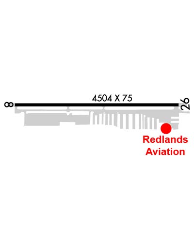
| Lat: N 3405.1 Long: W 11708.8 Elev: 1574 Var: -14 Longest Runway: 4504 | ||
| CTAF: 123.05 | ||
| |||||||||||||||||||||||
| |||||||||||||||||||||||
| Rwy | Rwy | |||||||
| 4504x75 | 4504' | 4504x75 | 4504' | |||||
| Runway ID | Single Wheel | Double Wheel | Double Tandem Wheel | Dual Double Wheel |
| 08/26 | 12,500 | N/A | N/A | N/A |
| These numbers are Advisory and are not limits. The Airport Manager should have more accurate Weight Limits | ||||
 Airport Diagram might not be current. | |
| Facility Name: | REDLANDS MUNI |
| City Name: | REDLANDS |
| County: | SAN BERNARDINO |
| State abbrev: | CA |
| State Name: | CALIFORNIA |
| Ownership: | PUBLICLY OWNED |
| Use: | OPEN TO THE PUBLIC |
| Owner's Name: | CITY OF REDLANDS |
| Address: | 35 CAJON STREET, SUITE 15A |
| REDLANDS, CA 92374 | |
| Owner's Phone: | 909-798-7668 |
| Manager's Name: | CARL BRUCE SHAFFER |
| Address: | 35 CAJON STREET, SUITE 222 |
| REDLANDS, CA 92373 | |
| Phone: | 909-557-8520; MAIN NO: 909-798-7655 |
| FAA Region: | WESTERN-PACIFIC |
| FAA Field Office: | LAX |
| Date | Sunrise | Sunset |
|---|---|---|
| 09/24/21 Friday | 6:38 | 18:43 |
| 09/25/21 Saturday | 6:39 | 18:41 |
| 09/26/21 Sunday | 6:39 | 18:40 |
| 09/27/21 Monday | 6:40 | 18:39 |
| 09/28/21 Tuesday | 6:41 | 18:37 |
| 09/29/21 Wednesday | 6:41 | 18:36 |
| 09/30/21 Thursday | 6:42 | 18:34 |
| 10/01/21 Friday | 6:43 | 18:33 |
| 10/02/21 Saturday | 6:44 | 18:32 |
| 10/03/21 Sunday | 6:44 | 18:30 |
| 10/04/21 Monday | 6:45 | 18:29 |
| 10/05/21 Tuesday | 6:46 | 18:28 |
| 10/06/21 Wednesday | 6:47 | 18:26 |
| 10/07/21 Thursday | 6:47 | 18:25 |
| Airport Attendance Schedule | 7 Days A Week 0800-1700 |
| Airport Status | OPERATIONAL (This Status can change at any time - please check NOTAMS) |
| Airport Lighting Schedule | ACTVT REIL RWYS 08 & 26; PAPI RWY 08; MIRL RWY 08/26 - CTAF. |
| Airport Storage Available | Tie Downs |
| Extra Services Available | Charter, Flight Instruction, Aircraft Rental, Aircraft Sales |
| Wind Indicator | YES - (lighted) |
| Control Tower | NO |
| CTAF Frequency | 123.050 |
| Unicom Frequency | 123.050; AUTOMATED UNICOM. |
| Rotating Beacon Color | CLEAR-GREEN (Light Land Airport) |
| Segmented Circle | YES |
| Landing Fee | NO |
| Airport Inspected | STATE - performed by STATE AERONAUTICAL PERSONNEL |
| Inspection Date | 01/11/2021 |
| Type of Fuel Available | Grade 100LL; -10SELF SERVE 100LL FUEL AVBL 24-7. |
| Airframe Repair Service | MAJOR |
| Power Plant Repair Service | MAJOR |
| Latitude | N3405.1 |
| Longitude | W11708.8 (ESTIMATED) |
| Arpt Elevation | 1574ft (SURVEYED) |
| Magnetic Variation | 14E |
| 2 miles NE | of REDLANDS |
| Traffic Pattern Altitude | 929; TPA - 929 FOR FIXED WING ACFT, N SIDE OF RWY 08/26; 500 FOR HEL, S SIDE OF RWY 08/26. |
| Sectional Chart | LOS ANGELES |
| Operations (Reported) | Yearly | Avg. Daily |
|---|---|---|
| General Aviation Transient | 11200 | 31 |
| General Aviation Local | 32800 | 90 |
| Air Taxi | 0 | 0 |
| Commerical | 0 | 0 |
| Commuter | 0 | 0 |
| Military | 0 | 0 |
| Aircraft based on Field | |
|---|---|
| General Aviation Singles | 157 |
| General Aviation Multi | 9 |
| Jet Aircraft | 1 |
| General Aviation Helicopters | 10 |
| Military Aircraft | 0 |
| Gliders | 2 |
| Ultralights | 0 |
| FSS on field | NO |
| FSS tie-in | RIVERSIDE |
| FSS Phone | 1-800-WX-BRIEF |
| Who issues Notams | RAL |
| Notam D service at airport | YES |
| ARTCC Name | LOS ANGELES |
| Airport Certification | |
| Aircraft Rescue & Firefighting Index | None |
| Airport of Entry | No |
| Custom Landing Rights | No |
| Joint Civil/Military | No |
| Military Landing rights | YES |
| NATIONAL PLAN OF INTEGRATED AIRPORT SYSTEMS (NPIAS) |
| GRANT AGREEMENTS UNDER FAAP/ADAP/AIP |
| ASSURANCES PURSUANT TO TITLE VI, CIVIL RIGHTS ACT OF 1964 |
| HEL ACTVTY AVOID NOISE SENSITIVE AREAS S OF ARPT. |
| AEROBATIC ACTVTY NE OF ARPT FROM 1500 FT AGL TO 7500 FT MSL; SEE SPECIAL NOTICE - AEROBATIC OPERATIONS NORTHEAST OF REDLANDS, CA. |
| COYOTES AND WATERFOWL ON AND INVOF ARPT. |
| FOR CD CTC SOCAL APCH AT 800-448-3724. |
Airport Communications & Frequencies:
| ||||||||||||||||
| Runway: 08 | Runway: 26 | ||
| Mag heading: | 76° | Mag heading: | 256° |
| Rwy Slope: | 2.28% Up | Rwy Slope: | -2.28% Down |
| Approach: | Approach: | ||
| Pattern: | Left Traffic | Pattern: | Right Traffic |
| Markings: | BASIC | Markings: | BASIC |
| Marking Condition: | GOOD | Marking Condition: | GOOD |
| Arresting Dev: | Arresting Dev: | ||
| Lat & Long: | N3405.1 W11709.2 | Lat. & Long.: | N3405.1 W11708.3 |
| Elev: | 1471.7 ft. MSL | Elev: | 1574.4 ft. MSL |
| TCH: | 40 ft. AGL | TCH: | |
| Visual Glide Path: | 3.00 degrees | Visual Glide Path: | |
| Displaced Threshold: | No | Displaced Threshold: | No |
| Touchdown Zone: | YES | Touchdown Zone: | YES |
| Touchdown Elev.: | 1536.5 feet | Touchdown Elev.: | 1574.4 feet |
| Visual Glide Slope: | 2-Light PAPI on LEFT side of Runway | Visual Glide Slope: | |
| RVR Equipment: | RVR Equipment: | ||
| RVV Equipment: | NO | RVV Equipment: | NO |
| Approach Lights: | Approach Lights: | ||
| REIL: | YES | REIL: | YES |
| Centerline Lights: | NO | Centerline Lights: | NO |
| Touchdown lights: | NO | Touchdown lights: | NO |
| Runway Category: | Runway with a Visual Approach | Runway Category: | Runway with a Visual Approach |
| Declared Distances: | Declared Distances: | ||
| Obstructions: | FENCE | Obstructions: | TREES |
| Marked: | NOT Marked/Lighted | Marked: | NOT Marked/Lighted |
| Clearance slope: | 25:1 | Clearance slope: | 22:1 |
| Obstruction height: | 4 feet AGL | Obstruction height: | 60 feet AGL |
| Dist. from runway: | 300 feet | Dist. from runway: | 1500 feet |
| Centerline offset: | 125 left of centerline | Centerline offset: | 120 feet left of centerline |
| Comments: | Comments: |
Thanks for using FltPlan.com
all rights reserved © 1999-2021 by Flight Plan LLC

