| RALEIGH-DURHAM INTL RALEIGH/DURHAM NC |
| |
| Lat: N 3552.7 Long: W 07847.2 Elev: 435 Var: +09 Longest Runway: 10000 | ||
| Clr Del: 120.1 Dept. ATIS: 123.8 Arr. ATIS: 123.8 Ground: 121.9 Tower: 127.45 | ||
| ||||||||||||||||||||||||||||||||||||||||||||||||||||||||||||||||||||
| ||||||||||||||||||||||||||||||||||||||||||||||||||||||||||||||||||||
| ||||||||||||||||||||||||||||||||||||||||||||||||||||||||||||||||||||
| ||||||||||||||||||||||||||||||||||||||||||||||||||||||||||||||||||||
| ||||||||||||||||||||||||||||||||||||||||||||||||||||||||||||||||||||
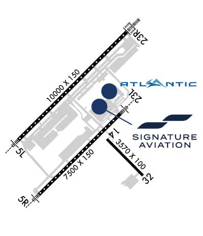
| Rwy | Rwy | |||||||
| 10000x150 | 10000' | 109.10 - 054° | 10000x150 | 10000' | 111.70 - 234° | |||
| 7500x150 | 7500' | 109.50 - 054° | 7500x150 | 7500' | 108.50 - 234° | |||
| 3570x100 | 3570' | 3570x100 | 3570' | |||||
| Runway ID | Single Wheel | Double Wheel | Double Tandem Wheel | Dual Double Wheel |
| 05L/23R | 75,000 | 190,000 | 355,000 | 750,000 |
| 05R/23L | 75,000 | 176,000 | 335,000 | 750,000 |
| 14/32 | 12,000 | N/A | N/A | N/A |
| These numbers are Advisory and are not limits. The Airport Manager should have more accurate Weight Limits | ||||
 Airport Diagram might not be current. | |
| Facility Name: | RALEIGH-DURHAM INTL |
| City Name: | RALEIGH/DURHAM |
| County: | WAKE |
| State abbrev: | NC |
| State Name: | NORTH CAROLINA |
| Ownership: | PUBLICLY OWNED |
| Use: | OPEN TO THE PUBLIC |
| Owner's Name: | RALEIGH-DURHAM ARPT AUTH |
| Address: | P.O. BOX 80001 |
| RDU AIRPORT, NC 27623 | |
| Owner's Phone: | 919-840-7700 |
| Manager's Name: | MICHAEL LANDGUTH |
| Address: | RALEIGH-DURHAM ARPT AUTH, P.O. BOX 80001 |
| RDU AIRPORT, NC 27623 | |
| Phone: | (919) 840-7701 |
| FAA Region: | SOUTHERN |
| FAA Field Office: | MEM |
| Date | Sunrise | Sunset |
|---|---|---|
| 06/08/26 Monday | 5:58 | 20:30 |
| 06/09/26 Tuesday | 5:58 | 20:31 |
| 06/10/26 Wednesday | 5:58 | 20:31 |
| 06/11/26 Thursday | 5:58 | 20:31 |
| 06/12/26 Friday | 5:58 | 20:32 |
| 06/13/26 Saturday | 5:58 | 20:32 |
| 06/14/26 Sunday | 5:58 | 20:33 |
| 06/15/26 Monday | 5:58 | 20:33 |
| 06/16/26 Tuesday | 5:58 | 20:33 |
| 06/17/26 Wednesday | 5:58 | 20:34 |
| 06/18/26 Thursday | 5:58 | 20:34 |
| 06/19/26 Friday | 5:59 | 20:34 |
| 06/20/26 Saturday | 5:59 | 20:35 |
| 06/21/26 Sunday | 5:59 | 20:35 |
| Airport Attendance Schedule | CONTINUOUS |
| Airport Status | OPERATIONAL (This Status can change at any time - please check NOTAMS) |
| Airport Lighting Schedule | SS-SR |
| Airport Storage Available | Tie Downs, Hanger |
| Extra Services Available | Air Freight, Air Ambulance, Avionics, Cargo Handling, Charter, Flight Instruction, Aircraft Rental, Aircraft Sales, Annual Surveying |
| Wind Indicator | YES - (lighted) |
| Control Tower | YES |
| CTAF Frequency | |
| Unicom Frequency | 122.950 |
| Rotating Beacon Color | WG; VISIBILITY OF BCN SHIELDED TO THE NORTH. |
| Segmented Circle | NO |
| Landing Fee | NO |
| Airport Inspected | FEDERAL - performed by FAA AIRPORTS FIELD PERSONNEL |
| Inspection Date | 05/16/2025 |
| Type of Fuel Available | Grade 100LL, JET A (freeze point -40C) |
| Airframe Repair Service | MAJOR |
| Power Plant Repair Service | MAJOR |
| Latitude | N3552.7 |
| Longitude | W07847.2 (ESTIMATED) |
| Arpt Elevation | 435ft (SURVEYED) |
| Magnetic Variation | 09W |
| 9 miles NW | of RALEIGH/DURHAM |
| Traffic Pattern Altitude | |
| Sectional Chart | CHARLOTTE |
| Operations (Reported) | Yearly | Avg. Daily |
|---|---|---|
| General Aviation Transient | 0 | 0 |
| General Aviation Local | 0 | 0 |
| Air Taxi | 0 | 0 |
| Commerical | 0 | 0 |
| Commuter | 0 | 0 |
| Military | 0 | 0 |
| Aircraft based on Field | |
|---|---|
| General Aviation Singles | 0 |
| General Aviation Multi | 0 |
| Jet Aircraft | 0 |
| General Aviation Helicopters | 0 |
| Military Aircraft | 0 |
| Gliders | 0 |
| Ultralights | 0 |
| FSS on field | NO |
| FSS tie-in | RALEIGH |
| FSS Phone | 1-800-WX-BRIEF |
| Who issues Notams | RDU |
| Notam D service at airport | YES |
| ARTCC Name | WASHINGTON |
| Airport Certification | AIRPORT RECEIVING SCHEDULED AIR CARRIER SERVICE FROM CARRIERS CERTIFICATED BY THE CIVIL AERONAUTICS BOARD |
| Aircraft Rescue & Firefighting Index | AIRPORT HAS A CERTIFICATE UNDER CFR PART 139 |
| Airport of Entry | No |
| Custom Landing Rights | YES |
| Joint Civil/Military | No |
| Military Landing rights | YES |
| NATIONAL PLAN OF INTEGRATED AIRPORT SYSTEMS (NPIAS) |
| GRANT AGREEMENTS UNDER FAAP/ADAP/AIP |
| SURPLUS PROPERTY AGREEMENT UNDER REGULATION 16-WAA |
| ASSURANCES PURSUANT TO TITLE VI, CIVIL RIGHTS ACT OF 1964 |
| AGREEMENT UNDER DLAND OR DCLA HAS EXPIRED. |
| NO JET ENGINE MAINTENANCE RUNS BETWEEN 0000-0600. |
| RSTD: PPR FOR ALL MILITARY AIRCRAFT F/W - R/W & UNSCHEDULED CHARTER FLIGHTS WITH 30 OR MORE PASSENGERS. 24 HR PN RQR FOR MIL PRACTICE APCH. CTC ARPT OPS 919-840-7510 OR RDU APP C919-380-3125. 24 HR PN RQR FOR PPR FOR ALL F/W AND R/W MIL ACFT GOING TO ARNG RAMP, POC C984-661-6200. OSACOM FLT DET C984-661-6202. |
| ARPT CLSD TO AIRSHIPS. |
| TWY E BEHIND SOUTH CARGO 4 & TWY J BEHIND CORPORATE HANGARS NOT VSBL FM ATCT. |
| ARNG: LTD PRK. ARNG OPS C984-661-6200. CTC FORECAST BASE 10 MIN PRIOR LDG. RAMP CLSD TO ALL F/W EXCEPT ARMY & MIL TRANSPORT WITH PPR, FACILITY HRS 1300-2130Z++ MON-FRI EXC HOL. MAKE APPT FOR AFTER DUTY HRS. OSACOM FLT DET C984-661-6202. |
| TWY F4 & F5 IS CLSD UFN. |
| ALL TDG V AIRCRAFT TXG ON TWY A ARE RSTD TO TAXI SPD OF 15 MPH. |
| APN TXL F BTN TWY T1 AND TWY T7 CLSD TO ACFT WITH WINGSPAN MORE THAN 171 FT. |
| NG PPR FOR LDG CTC V582-9181 C(919)664-9181. |
| TWY D CLSD TO ACFT WITH WINGSPAN MORE THAN 171 FT WHEN TWY G AND H ARE OCCUPIED. |
| TRML 1 ACFT MUST CTC ATC ON 121.9 PRIOR TO PUSH ONTO TWY A. TRML 2 ACFT MUST CTC RAMP TWR ON 130.175 PRIOR TO PUSH. NORTH CARGO APRON ADG IV OR V ACFT MUST CTC ATC ON 121.9 PRIOR TO PUSH. |
| TWY C BTN TWY F AND G IS RSTRD TO ACFT LESS THAN A MAX GROSS TKOF WEIGHT OF 490000 LBS. |
| TWY E CLSD TO AFCT WITH WINGSPAN MORE THAN 171 FT. |
| NG 24 HR PPR FOR JET ACFT & TRANS MIL ACFT - 919-840-7510. |
| RWY 05L/ 23RRWY 05L/23R UNGROOVED. |
| RWY 05L/ 23RPCR VALUE: 801/R/B/W/T |
| RWY 05R/ 23LPCR VALUE: 783/F/C/X/T |
Airport Communications & Frequencies:
| ||||||||||||||||||||||||||||||||||||||||||||
| Runway: 05L | Runway: 23R | ||
| Mag heading: | 54° | Mag heading: | 234° |
| Rwy Slope: | .42% Up | Rwy Slope: | -.42% Down |
| Approach: | ILS/DME | Approach: | ILS/DME |
| Pattern: | Left Traffic | Pattern: | Right Traffic |
| Markings: | PRECISION INSTRUMENT | Markings: | PRECISION INSTRUMENT |
| Marking Condition: | GOOD | Marking Condition: | GOOD |
| Arresting Dev: | Arresting Dev: | ||
| Lat & Long: | N3552.5 W07848.1 | Lat. & Long.: | N3553.6 W07846.7 |
| Elev: | 366.8 ft. MSL | Elev: | 408.6 ft. MSL |
| TCH: | 72 ft. AGL | TCH: | 69 ft. AGL |
| Visual Glide Path: | 3.00 degrees | Visual Glide Path: | 3.00 degrees |
| Displaced Threshold: | No | Displaced Threshold: | No |
| Touchdown Zone: | YES | Touchdown Zone: | YES |
| Touchdown Elev.: | 384.3 feet | Touchdown Elev.: | 408.6 feet |
| Visual Glide Slope: | 4-Light PAPI on LEFT side of Runway | Visual Glide Slope: | 4-Light PAPI on LEFT side of Runway |
| RVR Equipment: | TOUCHDOWN-MIDFIELD-ROLLOUT | RVR Equipment: | TOUCHDOWN-MIDFIELD-ROLLOUT |
| RVV Equipment: | YES | RVV Equipment: | YES |
| Approach Lights: | MALSR - 1,400 foot medium intensity approach lighting system with runway alignment indicator lights | Approach Lights: | ALSF2 - standard 2,400 foot high intensity approach lighting system with sequenced flashers, Category II or III |
| REIL: | NO | REIL: | NO |
| Centerline Lights: | YES | Centerline Lights: | YES |
| Touchdown lights: | YES | Touchdown lights: | YES |
| Runway Category: | Precision Instrument Runway | Runway Category: | Precision Instrument Runway |
| Declared Distances: | TORA:10000' TODA:10000' ASDA:10000' LDA:10000' | Declared Distances: | TORA:10000' TODA:10000' ASDA:10000' LDA:10000' |
| Runway: 05R | Runway: 23L | ||
| Mag heading: | 54° | Mag heading: | 234° |
| Rwy Slope: | .44% Up | Rwy Slope: | -.44% Down |
| Approach: | ILS/DME | Approach: | ILS/DME |
| Pattern: | Right Traffic | Pattern: | Left Traffic |
| Markings: | PRECISION INSTRUMENT | Markings: | PRECISION INSTRUMENT |
| Marking Condition: | GOOD | Marking Condition: | GOOD |
| Arresting Dev: | Arresting Dev: | ||
| Lat & Long: | N3551.9 W07847.8 | Lat. & Long.: | N3552.7 W07846.8 |
| Elev: | 397.5 ft. MSL | Elev: | 430.7 ft. MSL |
| TCH: | 62 ft. AGL | TCH: | 56 ft. AGL |
| Visual Glide Path: | 3.00 degrees | Visual Glide Path: | 3.00 degrees |
| Displaced Threshold: | No | Displaced Threshold: | No |
| Touchdown Zone: | YES | Touchdown Zone: | YES |
| Touchdown Elev.: | 419.8 feet | Touchdown Elev.: | 435.2 feet |
| Visual Glide Slope: | 4-Light PAPI on LEFT side of Runway | Visual Glide Slope: | 4-Light PAPI on LEFT side of Runway |
| RVR Equipment: | TOUCHDOWN-ROLLOUT | RVR Equipment: | TOUCHDOWN-ROLLOUT |
| RVV Equipment: | YES | RVV Equipment: | YES |
| Approach Lights: | MALSR - 1,400 foot medium intensity approach lighting system with runway alignment indicator lights | Approach Lights: | MALSR - 1,400 foot medium intensity approach lighting system with runway alignment indicator lights |
| REIL: | NO | REIL: | NO |
| Centerline Lights: | YES | Centerline Lights: | YES |
| Touchdown lights: | NO | Touchdown lights: | YES |
| Runway Category: | Precision Instrument Runway | Runway Category: | Precision Instrument Runway |
| Declared Distances: | TORA:7500' TODA:7500' ASDA:7500' LDA:7500' | Declared Distances: | TORA:7500' TODA:7500' ASDA:7500' LDA:7500' |
| Runway: 14 | Runway: 32 | ||
| Mag heading: | 144° | Mag heading: | 324° |
| Rwy Slope: | -.21% Down | Rwy Slope: | .21% Up |
| Approach: | Approach: | ||
| Pattern: | Left Traffic | Pattern: | Left Traffic |
| Markings: | NONPRECISION INSTRUMENT | Markings: | NONPRECISION INSTRUMENT |
| Marking Condition: | GOOD | Marking Condition: | GOOD |
| Arresting Dev: | Arresting Dev: | ||
| Lat & Long: | N3552.5 W07847.0 | Lat. & Long.: | N3552.1 W07846.5 |
| Elev: | 432.1 ft. MSL | Elev: | 424.7 ft. MSL |
| TCH: | TCH: | 47 ft. AGL | |
| Visual Glide Path: | Visual Glide Path: | 3.50 degrees | |
| Displaced Threshold: | No | Displaced Threshold: | No |
| Touchdown Zone: | YES | Touchdown Zone: | YES |
| Touchdown Elev.: | 432.1 feet | Touchdown Elev.: | 428.7 feet |
| Visual Glide Slope: | Visual Glide Slope: | 4-Light PAPI on LEFT side of Runway | |
| RVR Equipment: | RVR Equipment: | ||
| RVV Equipment: | NO | RVV Equipment: | NO |
| Approach Lights: | Approach Lights: | ||
| REIL: | NO | REIL: | YES |
| Centerline Lights: | NO | Centerline Lights: | NO |
| Touchdown lights: | NO | Touchdown lights: | NO |
| Runway Category: | Runway with a Visual Approach | Runway Category: | Runway with a Non-precision Approach having visibility minimums greater than 3/4 mile |
| Declared Distances: | Declared Distances: | ||
| Obstructions: | Obstructions: | TREES | |
| Marked: | Marked: | NOT Marked/Lighted | |
| Clearance slope: | 50:1 | Clearance slope: | 24:1 |
| Obstruction height: | Obstruction height: | 120 feet AGL | |
| Dist. from runway: | Dist. from runway: | 3046 feet | |
| Centerline offset: | Centerline offset: | 1 feet left of centerline | |
| Comments: | Comments: |
Thanks for using FltPlan.com
all rights reserved © 1999-2026 by Flight Plan LLC