| RICHMOND COUNTY ROCKINGHAM NC |
| |
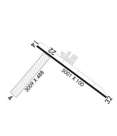
| Lat: N 3453.5 Long: W 07945.6 Elev: 358 Var: +08 Longest Runway: 5001 | ||
| AWOS: 118.77 CTAF: 122.8 | ||
| ||||||||||||||||||||||||||||||
| ||||||||||||||||||||||||||||||
| ||||||||||||||||||||||||||||||
| Rwy | Rwy | |||||||
| 3009x490 | 3009' | 3009x490 | 3009' | |||||
| 5001x100 | 4851' | 5001x100 | 4800' | |||||
| Runway ID | Single Wheel | Double Wheel | Double Tandem Wheel | Dual Double Wheel |
| 04/22 | N/A | N/A | N/A | N/A |
| 14/32 | 30,000 | N/A | N/A | N/A |
| These numbers are Advisory and are not limits. The Airport Manager should have more accurate Weight Limits | ||||
 Airport Diagram might not be current. | |
| Facility Name: | RICHMOND COUNTY |
| City Name: | ROCKINGHAM |
| County: | RICHMOND |
| State abbrev: | NC |
| State Name: | NORTH CAROLINA |
| Ownership: | PUBLICLY OWNED |
| Use: | OPEN TO THE PUBLIC |
| Owner's Name: | RICHMOND COUNTY |
| Address: | 656 AIRPORT ROAD |
| ROCKINGHAM, NC 28379 | |
| Owner's Phone: | 910-997-8211 |
| Manager's Name: | JASON GAINEY |
| Address: | 656 AIRPORT ROAD |
| ROCKINGHAM, NC 28379 | |
| Phone: | 910-997-5071 |
| FAA Region: | SOUTHERN |
| FAA Field Office: | MEM |
| Date | Sunrise | Sunset |
|---|---|---|
| 09/24/21 Friday | 7:08 | 19:13 |
| 09/25/21 Saturday | 7:09 | 19:12 |
| 09/26/21 Sunday | 7:10 | 19:10 |
| 09/27/21 Monday | 7:11 | 19:09 |
| 09/28/21 Tuesday | 7:11 | 19:08 |
| 09/29/21 Wednesday | 7:12 | 19:06 |
| 09/30/21 Thursday | 7:13 | 19:05 |
| 10/01/21 Friday | 7:14 | 19:03 |
| 10/02/21 Saturday | 7:14 | 19:02 |
| 10/03/21 Sunday | 7:15 | 19:01 |
| 10/04/21 Monday | 7:16 | 18:59 |
| 10/05/21 Tuesday | 7:17 | 18:58 |
| 10/06/21 Wednesday | 7:17 | 18:56 |
| 10/07/21 Thursday | 7:18 | 18:55 |
| Airport Attendance Schedule | MON-SAT 0700-1700; FOR ARPT ATTENDANT NIGHTS AND SUN CALL 910-997-5071. |
| Airport Status | OPERATIONAL (This Status can change at any time - please check NOTAMS) |
| Airport Lighting Schedule | ACTVT MIRL RWY 14/32 & PAPI RWY 14 & 32 & REIL RY 32 - CTAF. |
| Airport Storage Available | Tie Downs, Hanger |
| Extra Services Available | NONE |
| Wind Indicator | YES - (lighted) |
| Control Tower | NO |
| CTAF Frequency | 122.800 |
| Unicom Frequency | 122.800 |
| Rotating Beacon Color | CLEAR-GREEN (Light Land Airport) |
| Segmented Circle | YES |
| Landing Fee | NO |
| Airport Inspected | STATE - performed by STATE AERONAUTICAL PERSONNEL |
| Inspection Date | 06/06/2020 |
| Type of Fuel Available | Grade 100LL, JET A-1 (icing inhibitor, freeze point -50C); -10100LL AND JET A - 24 HR SELF-SERVICE WITH CREDIT CARD. |
| Airframe Repair Service | NONE |
| Power Plant Repair Service | NONE |
| Latitude | N3453.5 |
| Longitude | W07945.6 (ESTIMATED) |
| Arpt Elevation | 357ft (SURVEYED) |
| Magnetic Variation | 08W |
| 3 miles S | of ROCKINGHAM |
| Traffic Pattern Altitude | |
| Sectional Chart | CHARLOTTE |
| Operations (Reported) | Yearly | Avg. Daily |
|---|---|---|
| General Aviation Transient | 5000 | 14 |
| General Aviation Local | 5000 | 14 |
| Air Taxi | 0 | 0 |
| Commerical | 0 | 0 |
| Commuter | 0 | 0 |
| Military | 60 | 0 |
| Aircraft based on Field | |
|---|---|
| General Aviation Singles | 15 |
| General Aviation Multi | 3 |
| Jet Aircraft | 0 |
| General Aviation Helicopters | 0 |
| Military Aircraft | 0 |
| Gliders | 0 |
| Ultralights | 0 |
| FSS on field | NO |
| FSS tie-in | RALEIGH |
| FSS Phone | 1-800-WX-BRIEF |
| Who issues Notams | RCZ |
| Notam D service at airport | YES |
| ARTCC Name | WASHINGTON |
| Airport Certification | |
| Aircraft Rescue & Firefighting Index | None |
| Airport of Entry | No |
| Custom Landing Rights | No |
| Joint Civil/Military | No |
| Military Landing rights | YES |
| NATIONAL PLAN OF INTEGRATED AIRPORT SYSTEMS (NPIAS) |
| GRANT AGREEMENTS UNDER FAAP/ADAP/AIP |
| ASSURANCES PURSUANT TO TITLE VI, CIVIL RIGHTS ACT OF 1964 |
| AGREEMENT UNDER DLAND OR DCLA HAS EXPIRED. |
| RWY 14 HAS 60 FT DROP OFF 350 FT FROM DSPLCD THLD ALL SIDES. |
| RWY 04/22 NOT IN USE WHEN WET - TURBINE ENGINE ACFT AND ACFT OVER 10K LBS. CALL 910-997-5071 FOR RUNWAY CONDITIONS BEFORE LANDING. |
| FOR CD CTC WASHINGTON ARTCC AT 703-771-3587. |
| RWY 32 HAS NUMEROUS OBSTRUCTIONS IN APCH INCLUDING 5 FT FENCE, 12 FT ROAD, AND 20 FT RAILROAD |
Airport Communications & Frequencies:
| ||||||||||||||
| Runway: 04 | Runway: 22 | ||
| Mag heading: | 49° | Mag heading: | 229° |
| Rwy Slope: | -.27% Down | Rwy Slope: | .27% Up |
| Approach: | Approach: | ||
| Pattern: | Left Traffic | Pattern: | Left Traffic |
| Markings: | NONE | Markings: | NONE |
| Marking Condition: | Marking Condition: | ||
| Arresting Dev: | Arresting Dev: | ||
| Lat & Long: | N3453.3 W07946.1 | Lat. & Long.: | N3453.6 W07945.7 |
| Elev: | 356.4 ft. MSL | Elev: | 348.4 ft. MSL |
| TCH: | TCH: | ||
| Visual Glide Path: | Visual Glide Path: | ||
| Displaced Threshold: | No | Displaced Threshold: | No |
| Touchdown Zone: | YES | Touchdown Zone: | YES |
| Touchdown Elev.: | 357.5 feet | Touchdown Elev.: | 357.5 feet |
| Visual Glide Slope: | Visual Glide Slope: | ||
| RVR Equipment: | RVR Equipment: | ||
| RVV Equipment: | NO | RVV Equipment: | NO |
| Approach Lights: | Approach Lights: | ||
| REIL: | NO | REIL: | NO |
| Centerline Lights: | NO | Centerline Lights: | NO |
| Touchdown lights: | NO | Touchdown lights: | NO |
| Runway Category: | Runway with a Visual Approach | Runway Category: | Runway with a Visual Approach |
| Declared Distances: | Declared Distances: | ||
| Obstructions: | TREES | Obstructions: | TREES |
| Marked: | NOT Marked/Lighted | Marked: | NOT Marked/Lighted |
| Clearance slope: | 1:1 | Clearance slope: | 24:1 |
| Obstruction height: | 24 feet AGL | Obstruction height: | 82 feet AGL |
| Dist. from runway: | 38 feet | Dist. from runway: | 1998 feet |
| Centerline offset: | 69 right of centerline | Centerline offset: | 49 feet right of centerline |
| Comments: | Comments: |
| Runway: 14 | Runway: 32 | ||
| Mag heading: | 135° | Mag heading: | 315° |
| Rwy Slope: | .09% Up | Rwy Slope: | -.09% Down |
| Approach: | Approach: | ||
| Pattern: | Left Traffic | Pattern: | Left Traffic |
| Markings: | NONPRECISION INSTRUMENT | Markings: | NONPRECISION INSTRUMENT |
| Marking Condition: | FAIR | Marking Condition: | FAIR |
| Arresting Dev: | Arresting Dev: | ||
| Lat & Long: | N3453.7 W07945.8 | Lat. & Long.: | N3453.2 W07945.0 |
| Elev: | 349.8 ft. MSL | Elev: | 354.5 ft. MSL |
| TCH: | 25 ft. AGL | TCH: | 25 ft. AGL |
| Visual Glide Path: | 3.15 degrees | Visual Glide Path: | 3.15 degrees |
| Displaced Threshold: | 150 feet | Displaced Threshold: | 201 feet |
| Touchdown Zone: | YES | Touchdown Zone: | YES |
| Touchdown Elev.: | 355.9 feet | Touchdown Elev.: | 355.9 feet |
| Visual Glide Slope: | 2-Light PAPI on LEFT side of Runway | Visual Glide Slope: | 2-Light PAPI on LEFT side of Runway |
| RVR Equipment: | RVR Equipment: | ||
| RVV Equipment: | NO | RVV Equipment: | NO |
| Approach Lights: | Approach Lights: | ||
| REIL: | NO | REIL: | YES |
| Centerline Lights: | NO | Centerline Lights: | NO |
| Touchdown lights: | NO | Touchdown lights: | NO |
| Runway Category: | Runway with a Visual Approach | Runway Category: | Runway with a Non-precision Approach having visibility minimums greater than 3/4 mile |
| Declared Distances: | Declared Distances: | ||
| Obstructions: | TREES | Obstructions: | RR |
| Marked: | NOT Marked/Lighted | Marked: | NOT Marked/Lighted |
| Clearance slope: | 7:1; APCH SLOPE 12:1 AT DSPLCD THLD DUE TO 26 FT TREES 514 FT FROM DSPLCD THLD OFFSET 180 FT RIGHT OF CNTRLN. | Clearance slope: | APCH SLOPE 11:1 AT DSPLCD THLD DUE TO 20 FT RAILROAD 439 FT FROM DSPLCD THLD 235 FT RIGHT OF CNTRLN. |
| Obstruction height: | 21 feet AGL | Obstruction height: | 20 feet AGL |
| Dist. from runway: | 351 feet | Dist. from runway: | 215 feet |
| Centerline offset: | 157 right of centerline | Centerline offset: | 243 feet right of centerline |
| Comments: | Comments: | 15 FT ROAD, 5 FT FENCE, AND 20 FT RAILROAD ALL 0-200 FT FM RY END OFFSET BETWEEN 90-200 FT RIGHT OF CNTRLN. |
Thanks for using FltPlan.com
all rights reserved © 1999-2021 by Flight Plan LLC