
| NARTRON FIELD (CLOSED) REED CITY MI |
| |
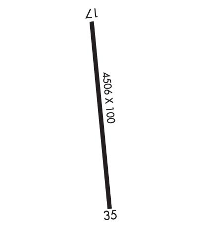
| Lat: N 4354.0 Long: W 08531.0 Elev: 1055 Var: +04 Longest Runway: 4506 | ||
| CTAF: 122.9 | ||
| |||||
|
| Rwy | Rwy | |||||||
| 4506x100 | 4506' | 4506x100 | 4506' | |||||
| Runway ID | Single Wheel | Double Wheel | Double Tandem Wheel | Dual Double Wheel |
| 17/35 | 11,000 | N/A | N/A | N/A |
| These numbers are Advisory and are not limits. The Airport Manager should have more accurate Weight Limits | ||||
| FltPlan does not have IFR approach charts available for KRCT. |
 Airport Diagram might not be current. | |
| Facility Name: | NARTRON FLD |
| City Name: | REED CITY |
| County: | OSCEOLA |
| State abbrev: | MI |
| State Name: | MICHIGAN |
| Ownership: | PRIVATELY OWNED |
| Use: | OPEN TO THE PUBLIC |
| Owner's Name: | NORMAN RAUTIOLA |
| Address: | 5000 OLD US HIGHWAY 131 |
| REED CITY, MI 49677-7922 | |
| Owner's Phone: | 231-832-5513 |
| Manager's Name: | NORMAN RAUTIOLA |
| Address: | 5000 OLD US HIGHWAY 131 |
| REED CITY, MI 49677-7922 | |
| Phone: | 231-832-5513 |
| FAA Region: | GREAT LAKES |
| FAA Field Office: | DET |
| Date | Sunrise | Sunset |
|---|---|---|
| 07/11/24 Thursday | 6:11 | 21:24 |
| 07/12/24 Friday | 6:12 | 21:24 |
| 07/13/24 Saturday | 6:12 | 21:23 |
| 07/14/24 Sunday | 6:13 | 21:22 |
| 07/15/24 Monday | 6:14 | 21:22 |
| 07/16/24 Tuesday | 6:15 | 21:21 |
| 07/17/24 Wednesday | 6:16 | 21:20 |
| 07/18/24 Thursday | 6:17 | 21:19 |
| 07/19/24 Friday | 6:18 | 21:18 |
| 07/20/24 Saturday | 6:19 | 21:18 |
| 07/21/24 Sunday | 6:20 | 21:17 |
| 07/22/24 Monday | 6:21 | 21:16 |
| 07/23/24 Tuesday | 6:22 | 21:15 |
| 07/24/24 Wednesday | 6:23 | 21:14 |
| Airport Attendance Schedule | UNATTENDED |
| Airport Status | OPERATIONAL (This Status can change at any time - please check NOTAMS) |
| Airport Lighting Schedule | |
| Airport Storage Available | NONE |
| Extra Services Available | NONE |
| Wind Indicator | NONE |
| Control Tower | NO |
| CTAF Frequency | 122.900 |
| Unicom Frequency | |
| Rotating Beacon Color | |
| Segmented Circle | NO |
| Landing Fee | NO |
| Airport Inspected | STATE - performed by STATE AERONAUTICAL PERSONNEL |
| Inspection Date | 09/27/2021 |
| Type of Fuel Available | None |
| Airframe Repair Service | NONE |
| Power Plant Repair Service | NONE |
| Latitude | N4354.0 |
| Longitude | W08531.0 (ESTIMATED) |
| Arpt Elevation | 1055ft (ESTIMATED) |
| Magnetic Variation | 04W |
| 2 miles N | of REED CITY |
| Traffic Pattern Altitude | |
| Sectional Chart | CHICAGO |
| Operations (Reported) | Yearly | Avg. Daily |
|---|---|---|
| General Aviation Transient | 5 | 0 |
| General Aviation Local | 0 | 0 |
| Air Taxi | 0 | 0 |
| Commerical | 0 | 0 |
| Commuter | 0 | 0 |
| Military | 0 | 0 |
| Aircraft based on Field | |
|---|---|
| General Aviation Singles | 0 |
| General Aviation Multi | 0 |
| Jet Aircraft | 0 |
| General Aviation Helicopters | 0 |
| Military Aircraft | 0 |
| Gliders | 0 |
| Ultralights | 0 |
| FSS on field | NO |
| FSS tie-in | LANSING |
| FSS Phone | 1-800-WX-BRIEF |
| Who issues Notams | LAN |
| Notam D service at airport | YES |
| ARTCC Name | MINNEAPOLIS |
| Airport Certification | |
| Aircraft Rescue & Firefighting Index | None |
| Airport of Entry | No |
| Custom Landing Rights | No |
| Joint Civil/Military | No |
| Military Landing rights | No |
| ARPT CLSD NOV THRU MAR & WHEN SNOW COVERED. |
| 40 FT TREES IN PRIMARY & TRANSITION SFCS RY 17/35, WEST SIDE. |
| 26 FT BLDGS 195 FT EAST OF RWY 35, + 50 FT BLDG, 235 FT EAST OF EXTENDED CNTRLN, SOUTH END OF RWY. |
| RY 17/35 -15 FT DROP OFF/ POND, 201 FT DSTC, 100 FT L. |
| FOR CD CTC MINNEAPOLIS ARTCC AT 651-463-5588. |
| RWY 17/3 5 CLSD TO TSNT ACFT CTC AMGR FOR DTLS. |
| RWY 17/3 5 ROUGH SFC; CRACKS IN RWY; CSDRBL AMT OF LOOSE STONES, ROCKS, VEGETATION, & SND ON PAVEMENT. |
| Runway: 17 | Runway: 35 | ||
| Mag heading: | N/A | Mag heading: | N/A |
| Rwy Slope: | .00% | Rwy Slope: | .00% |
| Approach: | Approach: | ||
| Pattern: | Left Traffic | Pattern: | Left Traffic |
| Markings: | NONE | Markings: | NONE |
| Marking Condition: | Marking Condition: | ||
| Arresting Dev: | Arresting Dev: | ||
| Lat & Long: | N4354.4 W08531.1 | Lat. & Long.: | N4353.6 W08530.9 |
| Elev: | 1055.0 ft. MSL | Elev: | 1055.0 ft. MSL |
| TCH: | TCH: | ||
| Visual Glide Path: | Visual Glide Path: | ||
| Displaced Threshold: | No | Displaced Threshold: | No |
| Touchdown Zone: | NO | Touchdown Zone: | NO |
| Touchdown Elev.: | Touchdown Elev.: | ||
| Visual Glide Slope: | Visual Glide Slope: | ||
| RVR Equipment: | RVR Equipment: | ||
| RVV Equipment: | NO | RVV Equipment: | NO |
| Approach Lights: | Approach Lights: | ||
| REIL: | NO | REIL: | NO |
| Centerline Lights: | NO | Centerline Lights: | NO |
| Touchdown lights: | NO | Touchdown lights: | NO |
| Runway Category: | Runway with a Visual Approach | Runway Category: | Runway with a Visual Approach |
| Declared Distances: | Declared Distances: | ||
| Obstructions: | TREES | Obstructions: | |
| Marked: | NOT Marked/Lighted | Marked: | |
| Clearance slope: | Clearance slope: | 20:1 | |
| Obstruction height: | 40 feet AGL | Obstruction height: | |
| Dist. from runway: | 201 feet | Dist. from runway: | |
| Centerline offset: | 70 right of centerline | Centerline offset: | |
| Comments: | +40 FT TREES 80 FT R 0 FT DSTC FM RY END. | Comments: |
Thanks for using FltPlan.com
all rights reserved © 1999-2024 by Flight Plan LLC
