
| SKYHAVEN WARRENSBURG MO |
| |
| Lat: N 3847.1 Long: W 09348.2 Elev: 798 Var: -01 Longest Runway: 4206 | ||
| AWOS: 119.57 CTAF: 123.0 | ||
| |||||||||||||||||||||||||||||||||||||||||||||||||||||||||||||||||||||
| |||||||||||||||||||||||||||||||||||||||||||||||||||||||||||||||||||||
| |||||||||||||||||||||||||||||||||||||||||||||||||||||||||||||||||||||
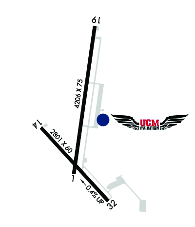
| Rwy | Rwy | |||||||
| 4206x75 | 4206' | 4206x75 | 4206' | |||||
| 2802x60 | 2802' | 2802x60 | 2802' | |||||
| Runway ID | Single Wheel | Double Wheel | Double Tandem Wheel | Dual Double Wheel |
| 01/19 | 21,000 | 26,000 | N/A | N/A |
| 14/32 | 12,500 | N/A | N/A | N/A |
| These numbers are Advisory and are not limits. The Airport Manager should have more accurate Weight Limits | ||||
 Airport Diagram might not be current. | |
| Facility Name: | SKYHAVEN |
| City Name: | WARRENSBURG |
| County: | JOHNSON |
| State abbrev: | MO |
| State Name: | MISSOURI |
| Ownership: | PUBLICLY OWNED |
| Use: | OPEN TO THE PUBLIC |
| Owner's Name: | UNIV. OF CENTRAL MISSOURI |
| Address: | T.R. GAINES, BLDG 210 |
| WARRENSBURG, MO 64093 | |
| Owner's Phone: | 660-543-4921 |
| Manager's Name: | DAN DIETZ |
| Address: | UNIVERSITY OF CENTRAL MISSOURI, 281 N.W. 50 HWY |
| WARRENSBURG, MO 64093 | |
| Phone: | (660) 543-4460; 660-422-1110 |
| FAA Region: | CENTRAL |
| FAA Field Office: | NONE |
| Date | Sunrise | Sunset |
|---|---|---|
| 09/24/21 Friday | 7:04 | 19:09 |
| 09/25/21 Saturday | 7:05 | 19:08 |
| 09/26/21 Sunday | 7:06 | 19:06 |
| 09/27/21 Monday | 7:07 | 19:05 |
| 09/28/21 Tuesday | 7:08 | 19:03 |
| 09/29/21 Wednesday | 7:09 | 19:01 |
| 09/30/21 Thursday | 7:10 | 19:00 |
| 10/01/21 Friday | 7:11 | 18:58 |
| 10/02/21 Saturday | 7:12 | 18:57 |
| 10/03/21 Sunday | 7:13 | 18:55 |
| 10/04/21 Monday | 7:14 | 18:54 |
| 10/05/21 Tuesday | 7:15 | 18:52 |
| 10/06/21 Wednesday | 7:16 | 18:51 |
| 10/07/21 Thursday | 7:17 | 18:49 |
| Airport Attendance Schedule | SAT 0800-1700, SUN 0900-1600, MON-FRI 0700-1900 |
| Airport Status | OPERATIONAL (This Status can change at any time - please check NOTAMS) |
| Airport Lighting Schedule | ACTVT REIL RWY 14 & 32; PAPI RWY 01 & 19; MIRL RWY 01/19 & 14/32 - CTAF. |
| Airport Storage Available | Tie Downs |
| Extra Services Available | Charter, Glider, Flight Instruction, Aircraft Rental, Annual Surveying, Glider Towing |
| Wind Indicator | YES - (lighted) |
| Control Tower | NO |
| CTAF Frequency | 123.000 |
| Unicom Frequency | 123.000 |
| Rotating Beacon Color | CLEAR-GREEN (Light Land Airport) |
| Segmented Circle | YES |
| Landing Fee | NO |
| Airport Inspected | STATE - performed by STATE AERONAUTICAL PERSONNEL |
| Inspection Date | 06/25/2020 |
| Type of Fuel Available | Grade 100LL, JET A (freeze point -40C) |
| Airframe Repair Service | MINOR |
| Power Plant Repair Service | MINOR |
| Latitude | N3847.1 |
| Longitude | W09348.2 (ESTIMATED) |
| Arpt Elevation | 797ft (SURVEYED) |
| Magnetic Variation | 01E |
| 3 miles NW | of WARRENSBURG |
| Traffic Pattern Altitude | |
| Sectional Chart | KANSAS CITY |
| Operations (Reported) | Yearly | Avg. Daily |
|---|---|---|
| General Aviation Transient | 2400 | 7 |
| General Aviation Local | 27000 | 74 |
| Air Taxi | 25 | 0 |
| Commerical | 0 | 0 |
| Commuter | 0 | 0 |
| Military | 300 | 1 |
| Aircraft based on Field | |
|---|---|
| General Aviation Singles | 45 |
| General Aviation Multi | 3 |
| Jet Aircraft | 0 |
| General Aviation Helicopters | 0 |
| Military Aircraft | 0 |
| Gliders | 1 |
| Ultralights | 0 |
| FSS on field | NO |
| FSS tie-in | COLUMBIA |
| FSS Phone | 1-800-WX-BRIEF |
| Who issues Notams | COU |
| Notam D service at airport | YES |
| ARTCC Name | KANSAS CITY |
| Airport Certification | |
| Aircraft Rescue & Firefighting Index | None |
| Airport of Entry | No |
| Custom Landing Rights | No |
| Joint Civil/Military | No |
| Military Landing rights | YES |
| NATIONAL PLAN OF INTEGRATED AIRPORT SYSTEMS (NPIAS) |
| GRANT AGREEMENTS UNDER FAAP/ADAP/AIP |
| ASSURANCES PURSUANT TO TITLE VI, CIVIL RIGHTS ACT OF 1964 |
| SOUTH 100 FT OF APRON & EXIT RAMP LCTD 1250 FT N OF RWY 01 THR HAS SAME PAVEMENT STRENGTH AS RWY 01/19; REMAINDER OF APRON NOT FULL STRENGTH. |
| LIMITED SIGHT DSTC FM RWY 14 THR AREA TO RWY 19 THR AND FM RWY 19 THR TO RWY 32 THR AREA. |
| HIGH VOL STUDENT TRNG INVOF ARPT FM 0700-1730 LCL MON THRU FRI. |
| FOR CD CTC WHITEMAN APCH AT 660-687-3132. WHEN WHITEMAN APCH IS CLSD, CTC KANSAS CITY ARTCC AT 913-254-8508. |
| RWY 01 CALM WIND RWY. |
Airport Communications & Frequencies:
| |||||||||||||||||
| Runway: 01 | Runway: 19 | ||
| Mag heading: | 7° | Mag heading: | 187° |
| Rwy Slope: | .16% Up | Rwy Slope: | -.16% Down |
| Approach: | Approach: | ||
| Pattern: | Left Traffic | Pattern: | Right Traffic |
| Markings: | NONPRECISION INSTRUMENT | Markings: | NONPRECISION INSTRUMENT |
| Marking Condition: | GOOD | Marking Condition: | GOOD |
| Arresting Dev: | Arresting Dev: | ||
| Lat & Long: | N3846.8 W09348.2 | Lat. & Long.: | N3847.5 W09348.1 |
| Elev: | 788.7 ft. MSL | Elev: | 795.3 ft. MSL |
| TCH: | 35 ft. AGL | TCH: | 39 ft. AGL |
| Visual Glide Path: | 3.00 degrees | Visual Glide Path: | 3.00 degrees |
| Displaced Threshold: | No | Displaced Threshold: | No |
| Touchdown Zone: | YES | Touchdown Zone: | YES |
| Touchdown Elev.: | 794.1 feet | Touchdown Elev.: | 795.3 feet |
| Visual Glide Slope: | 4-Light PAPI on LEFT side of Runway | Visual Glide Slope: | 4-Light PAPI on LEFT side of Runway |
| RVR Equipment: | RVR Equipment: | ||
| RVV Equipment: | NO | RVV Equipment: | NO |
| Approach Lights: | Approach Lights: | ||
| REIL: | YES | REIL: | YES |
| Centerline Lights: | NO | Centerline Lights: | NO |
| Touchdown lights: | NO | Touchdown lights: | NO |
| Runway Category: | Runway with a Non-precision Approach having visibility minimums greater than 3/4 mile | Runway Category: | Runway with a Non-precision Approach having visibility minimums greater than 3/4 mile |
| Declared Distances: | Declared Distances: | ||
| Obstructions: | TREES | Obstructions: | |
| Marked: | NOT Marked/Lighted | Marked: | |
| Clearance slope: | 12:1 | Clearance slope: | 34:1 |
| Obstruction height: | 39 feet AGL | Obstruction height: | |
| Dist. from runway: | 700 feet | Dist. from runway: | |
| Centerline offset: | 165 left of centerline | Centerline offset: | |
| Comments: | Comments: |
| Runway: 14 | Runway: 32 | ||
| Mag heading: | 136° | Mag heading: | 316° |
| Rwy Slope: | -.43% Down | Rwy Slope: | .43% Up |
| Approach: | Approach: | ||
| Pattern: | Right Traffic | Pattern: | Left Traffic |
| Markings: | BASIC | Markings: | BASIC |
| Marking Condition: | FAIR | Marking Condition: | FAIR |
| Arresting Dev: | Arresting Dev: | ||
| Lat & Long: | N3847.0 W09348.4 | Lat. & Long.: | N3846.7 W09348.0 |
| Elev: | 797.8 ft. MSL | Elev: | 785.7 ft. MSL |
| TCH: | TCH: | ||
| Visual Glide Path: | Visual Glide Path: | ||
| Displaced Threshold: | No | Displaced Threshold: | No |
| Touchdown Zone: | YES | Touchdown Zone: | YES |
| Touchdown Elev.: | 797.8 feet | Touchdown Elev.: | 797.8 feet |
| Visual Glide Slope: | Visual Glide Slope: | ||
| RVR Equipment: | RVR Equipment: | ||
| RVV Equipment: | NO | RVV Equipment: | NO |
| Approach Lights: | Approach Lights: | ||
| REIL: | YES | REIL: | YES |
| Centerline Lights: | NO | Centerline Lights: | NO |
| Touchdown lights: | NO | Touchdown lights: | NO |
| Runway Category: | Runway with a Visual Approach | Runway Category: | Runway with a Visual Approach |
| Declared Distances: | Declared Distances: | ||
| Obstructions: | TREES | Obstructions: | ROAD |
| Marked: | NOT Marked/Lighted | Marked: | NOT Marked/Lighted |
| Clearance slope: | 14:1 | Clearance slope: | 11:1 |
| Obstruction height: | 20 feet AGL | Obstruction height: | 15 feet AGL |
| Dist. from runway: | 480 feet | Dist. from runway: | 375 feet |
| Centerline offset: | 98 right of centerline | Centerline offset: | 125 feet right of centerline |
| Comments: | Comments: |
Thanks for using FltPlan.com
all rights reserved © 1999-2021 by Flight Plan LLC


