| LOWCOUNTRY RGNL WALTERBORO SC |
| |
| Lat: N 3255.3 Long: W 08038.4 Elev: 101 Var: +05 Longest Runway: 6002 | ||
| AWOS: 118.72 CTAF: 122.8 | ||
| |||||||||||||||||||||||||||||||||||||||||||||||||||||||||||||||||||||
| |||||||||||||||||||||||||||||||||||||||||||||||||||||||||||||||||||||
| |||||||||||||||||||||||||||||||||||||||||||||||||||||||||||||||||||||
| |||||||||||||||||||||||||||||||||||||||||||||||||||||||||||||||||||||
| Rwy | Rwy | |||||||
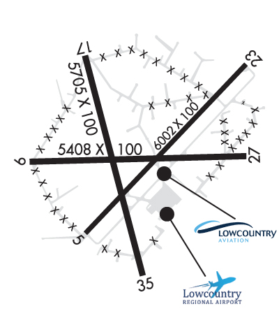
| 6002x100 | 6002' | 6002x100 | 6002' | 110.15 - 229° | ||||
| 5705x100 | 5705' | 5705x100 | 5705' | |||||
| Runway ID | Single Wheel | Double Wheel | Double Tandem Wheel | Dual Double Wheel |
| 05/23 | 70,000 | 101,000 | N/A | N/A |
| 17/35 | 33,500 | 50,500 | N/A | N/A |
| These numbers are Advisory and are not limits. The Airport Manager should have more accurate Weight Limits | ||||
 Airport Diagram might not be current. | |
| Facility Name: | LOWCOUNTRY RGNL |
| City Name: | WALTERBORO |
| County: | COLLETON |
| State abbrev: | SC |
| State Name: | SOUTH CAROLINA |
| Ownership: | PUBLICLY OWNED |
| Use: | OPEN TO THE PUBLIC |
| Owner's Name: | CITY OF WALTERBORO AND COLLETON CO. |
| Address: | 537 AVIATION WAY |
| WALTERBORO, SC 29488 | |
| Owner's Phone: | 843-549-2549 |
| Manager's Name: | BERT DUFFIE |
| Address: | 537 AVIATION WAY |
| WALTERBORO, SC 29488 | |
| Phone: | 843-549-2549 |
| FAA Region: | SOUTHERN |
| FAA Field Office: | ATL |
| Date | Sunrise | Sunset |
|---|---|---|
| 06/08/26 Monday | 6:14 | 20:30 |
| 06/09/26 Tuesday | 6:14 | 20:30 |
| 06/10/26 Wednesday | 6:14 | 20:30 |
| 06/11/26 Thursday | 6:14 | 20:31 |
| 06/12/26 Friday | 6:14 | 20:31 |
| 06/13/26 Saturday | 6:14 | 20:32 |
| 06/14/26 Sunday | 6:14 | 20:32 |
| 06/15/26 Monday | 6:14 | 20:32 |
| 06/16/26 Tuesday | 6:14 | 20:33 |
| 06/17/26 Wednesday | 6:14 | 20:33 |
| 06/18/26 Thursday | 6:14 | 20:33 |
| 06/19/26 Friday | 6:14 | 20:34 |
| 06/20/26 Saturday | 6:14 | 20:34 |
| 06/21/26 Sunday | 6:14 | 20:34 |
| Airport Attendance Schedule | 7 Days A Week 0800-1800; CLSD CHRISTMAS DAY. |
| Airport Status | OPERATIONAL (This Status can change at any time - please check NOTAMS) |
| Airport Lighting Schedule | ODALS RWY 23; REILS RWY 23; PAPI RWY 05 & 23; MIRLS RWY 05/23 - OPR CONSLY FM DUSK-2200. FM 2200 TO DAWN ACTVT ODALS RWY 23; MIRLS RWY 05/23 - CTAF. |
| Airport Storage Available | Tie Downs, Hanger |
| Extra Services Available | Flight Instruction, Parachute Jumping |
| Wind Indicator | YES - (lighted) |
| Control Tower | NO |
| CTAF Frequency | 122.800 |
| Unicom Frequency | 122.800 |
| Rotating Beacon Color | WG |
| Segmented Circle | NO |
| Landing Fee | NO |
| Airport Inspected | STATE - performed by STATE AERONAUTICAL PERSONNEL |
| Inspection Date | 04/23/2026 |
| Type of Fuel Available | Grade 100LL, JET A (freeze point -40C); -A FOR AFT HRS SVC CALL 843-549-2549.; -10100LL SELF-SVC FUEL AVBL 24 HRS. |
| Airframe Repair Service | MAJOR |
| Power Plant Repair Service | MAJOR |
| Latitude | N3255.3 |
| Longitude | W08038.4 (ESTIMATED) |
| Arpt Elevation | 100ft (SURVEYED) |
| Magnetic Variation | 05W |
| 2 miles NE | of WALTERBORO |
| Traffic Pattern Altitude | |
| Sectional Chart | CHARLOTTE |
| Operations (Reported) | Yearly | Avg. Daily |
|---|---|---|
| General Aviation Transient | 0 | 0 |
| General Aviation Local | 0 | 0 |
| Air Taxi | 0 | 0 |
| Commerical | 0 | 0 |
| Commuter | 0 | 0 |
| Military | 0 | 0 |
| Aircraft based on Field | |
|---|---|
| General Aviation Singles | 0 |
| General Aviation Multi | 0 |
| Jet Aircraft | 0 |
| General Aviation Helicopters | 0 |
| Military Aircraft | 0 |
| Gliders | 0 |
| Ultralights | 0 |
| FSS on field | NO |
| FSS tie-in | ANDERSON |
| FSS Phone | 1-800-WX-BRIEF |
| Who issues Notams | AND |
| Notam D service at airport | YES |
| ARTCC Name | JACKSONVILLE |
| Airport Certification | |
| Aircraft Rescue & Firefighting Index | None |
| Airport of Entry | No |
| Custom Landing Rights | No |
| Joint Civil/Military | No |
| Military Landing rights | YES |
| NATIONAL PLAN OF INTEGRATED AIRPORT SYSTEMS (NPIAS) |
| GRANT AGREEMENTS UNDER FAAP/ADAP/AIP |
| SURPLUS PROPERTY AGREEMENT UNDER REGULATION 16-WAA |
| ASSURANCES PURSUANT TO TITLE VI, CIVIL RIGHTS ACT OF 1964 |
| AGREEMENT UNDER DLAND OR DCLA HAS EXPIRED. |
| FOR CD CTC CHARLESTON APCH AT 843 414-2832. |
| DEER ON AND INVOF ARPT WITH INCR ACT DRG NGT AND AT DUSK AND DAWN. |
Airport Communications & Frequencies:
| ||||||||||||||
| Runway: 05 | Runway: 23 | ||
| Mag heading: | 49° | Mag heading: | 229° |
| Rwy Slope: | .19% Up | Rwy Slope: | -.19% Down |
| Approach: | Approach: | ILS/DME | |
| Pattern: | Left Traffic | Pattern: | Left Traffic |
| Markings: | NONPRECISION INSTRUMENT | Markings: | PRECISION INSTRUMENT |
| Marking Condition: | GOOD | Marking Condition: | GOOD |
| Arresting Dev: | Arresting Dev: | ||
| Lat & Long: | N3254.9 W08038.7 | Lat. & Long.: | N3255.7 W08037.9 |
| Elev: | 89.4 ft. MSL | Elev: | 100.9 ft. MSL |
| TCH: | 49 ft. AGL | TCH: | 46 ft. AGL |
| Visual Glide Path: | 3.50 degrees | Visual Glide Path: | 3.00 degrees |
| Displaced Threshold: | No | Displaced Threshold: | No |
| Touchdown Zone: | YES | Touchdown Zone: | YES |
| Touchdown Elev.: | 96.4 feet | Touchdown Elev.: | 100.9 feet |
| Visual Glide Slope: | 2-Light PAPI on LEFT side of Runway | Visual Glide Slope: | 2-Light PAPI on LEFT side of Runway |
| RVR Equipment: | RVR Equipment: | ||
| RVV Equipment: | NO | RVV Equipment: | NO |
| Approach Lights: | Approach Lights: | ODALS - omnidirectional approach lighting system | |
| REIL: | NO | REIL: | YES |
| Centerline Lights: | NO | Centerline Lights: | NO |
| Touchdown lights: | NO | Touchdown lights: | NO |
| Runway Category: | Runway with a Non-precision Approach having visibility minimums greater than 3/4 mile | Runway Category: | Precision Instrument Runway |
| Declared Distances: | TORA:6002' TODA:6002' ASDA:6002' LDA:6002' | Declared Distances: | TORA:6002' TODA:6002' ASDA:5977' LDA:5977' |
| Obstructions: | TREES | Obstructions: | TREES |
| Marked: | NOT Marked/Lighted | Marked: | NOT Marked/Lighted |
| Clearance slope: | 21:1 | Clearance slope: | 27:1 |
| Obstruction height: | 82 feet AGL | Obstruction height: | 99 feet AGL |
| Dist. from runway: | 1999 feet | Dist. from runway: | 2932 feet |
| Centerline offset: | 265 right of centerline | Centerline offset: | 751 feet left of centerline |
| Comments: | Comments: |
| Runway: 17 | Runway: 35 | ||
| Mag heading: | 171° | Mag heading: | 351° |
| Rwy Slope: | .16% Up | Rwy Slope: | -.16% Down |
| Approach: | Approach: | ||
| Pattern: | Left Traffic | Pattern: | Left Traffic |
| Markings: | NONPRECISION INSTRUMENT | Markings: | NONPRECISION INSTRUMENT |
| Marking Condition: | GOOD | Marking Condition: | GOOD |
| Arresting Dev: | Arresting Dev: | ||
| Lat & Long: | N3255.7 W08038.7 | Lat. & Long.: | N3254.8 W08038.4 |
| Elev: | 82.3 ft. MSL | Elev: | 91.6 ft. MSL |
| TCH: | TCH: | ||
| Visual Glide Path: | Visual Glide Path: | ||
| Displaced Threshold: | No | Displaced Threshold: | No |
| Touchdown Zone: | YES | Touchdown Zone: | YES |
| Touchdown Elev.: | 92.5 feet | Touchdown Elev.: | 95.2 feet |
| Visual Glide Slope: | Visual Glide Slope: | ||
| RVR Equipment: | RVR Equipment: | ||
| RVV Equipment: | NO | RVV Equipment: | NO |
| Approach Lights: | Approach Lights: | ||
| REIL: | NO | REIL: | NO |
| Centerline Lights: | NO | Centerline Lights: | NO |
| Touchdown lights: | NO | Touchdown lights: | NO |
| Runway Category: | Runway with a Non-precision Approach having visibility minimums greater than 3/4 mile | Runway Category: | Runway with a Non-precision Approach having visibility minimums greater than 3/4 mile |
| Declared Distances: | Declared Distances: | ||
| Obstructions: | TREE | Obstructions: | TREE |
| Marked: | NOT Marked/Lighted | Marked: | NOT Marked/Lighted |
| Clearance slope: | 30:1 | Clearance slope: | 23:1 |
| Obstruction height: | 59 feet AGL | Obstruction height: | 43 feet AGL |
| Dist. from runway: | 1984 feet | Dist. from runway: | 1214 feet |
| Centerline offset: | 229 right of centerline | Centerline offset: | 308 feet right of centerline |
| Comments: | Comments: |
Thanks for using FltPlan.com
all rights reserved © 1999-2026 by Flight Plan LLC