
| DALLAS EXECUTIVE DALLAS TX |
| |
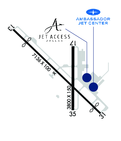
| Lat: N 3240.9 Long: W 09652.1 Elev: 661 Var: -06 Longest Runway: 7136 | ||
| Clr Del: 118.62 Dept. ATIS: 126.35 Arr. ATIS: 126.35 Ground: 119.47 Tower: 127.25 | ||
| |||||||||||||||||||||||||||||||||||||||||||||||||||||||||||||||||||||
| |||||||||||||||||||||||||||||||||||||||||||||||||||||||||||||||||||||
| |||||||||||||||||||||||||||||||||||||||||||||||||||||||||||||||||||||
| |||||||||||||||||||||||||||||||||||||||||||||||||||||||||||||||||||||
| |||||||||||||||||||||||||||||||||||||||||||||||||||||||||||||||||||||
| Rwy | Rwy | |||||||
| 7136x100 | 6051' | 7136x100 | 6636' | 110.75 - 309° | ||||
| 3800x150 | 3800' | 3800x150 | 3800' | |||||
| Runway ID | Single Wheel | Double Wheel | Double Tandem Wheel | Dual Double Wheel |
| 13/31 | 40,000 | 90,000 | 130,000 | N/A |
| 17/35 | 35,000 | 60,000 | 110,000 | N/A |
| These numbers are Advisory and are not limits. The Airport Manager should have more accurate Weight Limits | ||||
 Airport Diagram might not be current. | |
| Facility Name: | DALLAS EXEC |
| City Name: | DALLAS |
| County: | DALLAS |
| State abbrev: | TX |
| State Name: | TEXAS |
| Ownership: | PUBLICLY OWNED |
| Use: | OPEN TO THE PUBLIC |
| Owner's Name: | CITY OF DALLAS |
| Address: | 1500 MARILLA |
| DALLAS, TX 75201 | |
| Owner's Phone: | 214-670-7612 |
| Manager's Name: | RAFAEL GARZA JR. |
| Address: | 5303 CHALLENGER DR |
| DALLAS, TX 75237 | |
| Phone: | 214-670-7612 |
| FAA Region: | SOUTHWEST |
| FAA Field Office: | TEX |
| Date | Sunrise | Sunset |
|---|---|---|
| 06/07/26 Sunday | 6:19 | 20:33 |
| 06/08/26 Monday | 6:19 | 20:34 |
| 06/09/26 Tuesday | 6:19 | 20:34 |
| 06/10/26 Wednesday | 6:19 | 20:35 |
| 06/11/26 Thursday | 6:19 | 20:35 |
| 06/12/26 Friday | 6:19 | 20:36 |
| 06/13/26 Saturday | 6:19 | 20:36 |
| 06/14/26 Sunday | 6:19 | 20:36 |
| 06/15/26 Monday | 6:19 | 20:37 |
| 06/16/26 Tuesday | 6:19 | 20:37 |
| 06/17/26 Wednesday | 6:19 | 20:37 |
| 06/18/26 Thursday | 6:20 | 20:38 |
| 06/19/26 Friday | 6:20 | 20:38 |
| 06/20/26 Saturday | 6:20 | 20:38 |
| Airport Attendance Schedule | 7 Days A Week 0600-2000; ON CALL AFT HRS. |
| Airport Status | OPERATIONAL (This Status can change at any time - please check NOTAMS) |
| Airport Lighting Schedule | WHEN ATCT CLSD MIRL RWYS 13/31& 17/35 PRESET LOW INTST; TO INCR INTST ACTVT - CTAF. |
| Airport Storage Available | Tie Downs, Hanger |
| Extra Services Available | Avionics, Charter, Flight Instruction, Aircraft Rental, Aircraft Sales |
| Wind Indicator | YES - (lighted) |
| Control Tower | YES |
| CTAF Frequency | 127.250 |
| Unicom Frequency | 122.950 |
| Rotating Beacon Color | WG |
| Segmented Circle | YES |
| Landing Fee |
| Airport Inspected | STATE - performed by PRIVATE CONTRACT PERSONNEL |
| Inspection Date | 05/16/2025 |
| Type of Fuel Available | Grade 100LL, JET A (freeze point -40C); -10FUEL AVBL 24 HR. |
| Airframe Repair Service | MAJOR |
| Power Plant Repair Service | MAJOR |
| Latitude | N3240.9 |
| Longitude | W09652.1 (ESTIMATED) |
| Arpt Elevation | 660ft (ESTIMATED) |
| Magnetic Variation | 06E |
| 6 miles SW | of DALLAS |
| Traffic Pattern Altitude | |
| Sectional Chart | DALLAS-FT WORTH |
| Operations (Reported) | Yearly | Avg. Daily |
|---|---|---|
| General Aviation Transient | 0 | 0 |
| General Aviation Local | 0 | 0 |
| Air Taxi | 0 | 0 |
| Commerical | 0 | 0 |
| Commuter | 0 | 0 |
| Military | 0 | 0 |
| Aircraft based on Field | |
|---|---|
| General Aviation Singles | 0 |
| General Aviation Multi | 0 |
| Jet Aircraft | 0 |
| General Aviation Helicopters | 0 |
| Military Aircraft | 0 |
| Gliders | 0 |
| Ultralights | 0 |
| FSS on field | NO |
| FSS tie-in | FORT WORTH |
| FSS Phone | 1-800-WX-BRIEF |
| Who issues Notams | RBD |
| Notam D service at airport | YES |
| ARTCC Name | FORT WORTH |
| Airport Certification | |
| Aircraft Rescue & Firefighting Index | None |
| Airport of Entry | No |
| Custom Landing Rights | No |
| Joint Civil/Military | No |
| Military Landing rights | No |
| NATIONAL PLAN OF INTEGRATED AIRPORT SYSTEMS (NPIAS) |
| GRANT AGREEMENTS UNDER FAAP/ADAP/AIP |
| ASSURANCES PURSUANT TO TITLE VI, CIVIL RIGHTS ACT OF 1964 |
| BIRDS & WILDLIFE ON & INVOF ARPT. |
Airport Communications & Frequencies:
| ||||||||||||||||||||||||
| Runway: 13 | Runway: 31 | ||
| Mag heading: | 129° | Mag heading: | 309° |
| Rwy Slope: | -.09% Down | Rwy Slope: | .09% Up |
| Approach: | Approach: | ILS/DME | |
| Pattern: | Left Traffic | Pattern: | Left Traffic |
| Markings: | NONPRECISION INSTRUMENT | Markings: | PRECISION INSTRUMENT |
| Marking Condition: | GOOD | Marking Condition: | GOOD |
| Arresting Dev: | Arresting Dev: | ||
| Lat & Long: | N3241.3 W09652.7 | Lat. & Long.: | N3240.5 W09651.7 |
| Elev: | 653.4 ft. MSL | Elev: | 646.9 ft. MSL |
| TCH: | 40 ft. AGL | TCH: | 45 ft. AGL |
| Visual Glide Path: | 3.00 degrees | Visual Glide Path: | 3.00 degrees |
| Displaced Threshold: | 1085 feet | Displaced Threshold: | 500 feet |
| Touchdown Zone: | YES | Touchdown Zone: | YES |
| Touchdown Elev.: | 657.3 feet | Touchdown Elev.: | 659.8 feet |
| Visual Glide Slope: | 4-Light PAPI on LEFT side of Runway | Visual Glide Slope: | 4-Light PAPI on RIGHT side of Runway |
| RVR Equipment: | RVR Equipment: | ||
| RVV Equipment: | NO | RVV Equipment: | NO |
| Approach Lights: | Approach Lights: | ||
| REIL: | YES | REIL: | YES |
| Centerline Lights: | NO | Centerline Lights: | NO |
| Touchdown lights: | NO | Touchdown lights: | NO |
| Runway Category: | Runway with a Visual Approach | Runway Category: | Precision Instrument Runway |
| Declared Distances: | TORA:6766' TODA:7136' ASDA:6622' LDA:5537' | Declared Distances: | TORA:6051' TODA:7136' ASDA:7101' LDA:6601' |
| Obstructions: | TREES | Obstructions: | ROAD |
| Marked: | NOT Marked/Lighted | Marked: | NOT Marked/Lighted |
| Clearance slope: | APCH SLOPE 0:1 TO DSPLCD THLD OVR 20 FT TREES, 0 FT DSTC, 395 FT R. | Clearance slope: | 49:1 |
| Obstruction height: | 42 feet AGL | Obstruction height: | 7 feet AGL |
| Dist. from runway: | 201 feet | Dist. from runway: | 547 feet |
| Centerline offset: | 457 right of centerline | Centerline offset: | 513 feet right of centerline |
| Comments: | 25 FT TREES, 0-199 FT DSTC, 399 FT R. 15 FT CONC WALL, 0 FT DSTC, 385 L. | Comments: |
| Runway: 17 | Runway: 35 | ||
| Mag heading: | 174° | Mag heading: | 354° |
| Rwy Slope: | .23% Up | Rwy Slope: | -.23% Down |
| Approach: | Approach: | ||
| Pattern: | Left Traffic | Pattern: | Left Traffic |
| Markings: | NONPRECISION INSTRUMENT | Markings: | NONPRECISION INSTRUMENT |
| Marking Condition: | GOOD | Marking Condition: | GOOD |
| Arresting Dev: | Arresting Dev: | ||
| Lat & Long: | N3241.1 W09652.0 | Lat. & Long.: | N3240.5 W09652.0 |
| Elev: | 650.6 ft. MSL | Elev: | 659.2 ft. MSL |
| TCH: | 43 ft. AGL | TCH: | |
| Visual Glide Path: | 3.00 degrees | Visual Glide Path: | |
| Displaced Threshold: | No | Displaced Threshold: | No |
| Touchdown Zone: | YES | Touchdown Zone: | YES |
| Touchdown Elev.: | 657.9 feet | Touchdown Elev.: | 659.2 feet |
| Visual Glide Slope: | 4-Light PAPI on RIGHT side of Runway | Visual Glide Slope: | |
| RVR Equipment: | RVR Equipment: | ||
| RVV Equipment: | NO | RVV Equipment: | NO |
| Approach Lights: | Approach Lights: | ||
| REIL: | YES | REIL: | YES |
| Centerline Lights: | NO | Centerline Lights: | NO |
| Touchdown lights: | NO | Touchdown lights: | NO |
| Runway Category: | Runway with a Non-precision Approach having visibility minimums greater than 3/4 mile | Runway Category: | Runway with a Non-precision Approach having visibility minimums greater than 3/4 mile |
| Declared Distances: | Declared Distances: | ||
| Obstructions: | TREES | Obstructions: | |
| Marked: | NOT Marked/Lighted | Marked: | |
| Clearance slope: | 31:1 | Clearance slope: | 50:1 |
| Obstruction height: | 18 feet AGL | Obstruction height: | |
| Dist. from runway: | 770 feet | Dist. from runway: | |
| Centerline offset: | 800 right of centerline | Centerline offset: | |
| Comments: | Comments: |
Thanks for using FltPlan.com
all rights reserved © 1999-2026 by Flight Plan LLC