
| CHICAGO EXECUTIVE CHICAGO/PROSPECT HGT IL |
| |
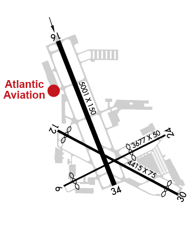
| Lat: N 4206.9 Long: W 08754.1 Elev: 647 Var: +02 Longest Runway: 5001 | ||
| Clr Del: 124.7 Dept. ATIS: 124.2 Arr. ATIS: 124.2 Ground: 121.7 Tower: 119.9 | ||

| ||||||||||||||||||||||||||||||||||||||||||||||||||||||||||||||||||||
| ||||||||||||||||||||||||||||||||||||||||||||||||||||||||||||||||||||
| ||||||||||||||||||||||||||||||||||||||||||||||||||||||||||||||||||||
| ||||||||||||||||||||||||||||||||||||||||||||||||||||||||||||||||||||
| ||||||||||||||||||||||||||||||||||||||||||||||||||||||||||||||||||||
| Rwy | Rwy | |||||||
| 3677x50 | 3304' | 3677x50 | 2429' | |||||
| 4415x75 | 4120' | 4415x75 | 3983' | |||||
| 5001x150 | 5001' | 109.75 - 160° | 5001x150 | 5001' | ||||
| Runway ID | Single Wheel | Double Wheel | Double Tandem Wheel | Dual Double Wheel |
| 06/24 | 20,000 | 30,000 | N/A | N/A |
| 12/30 | 18,000 | 28,000 | N/A | N/A |
| 16/34 | 72,000 | 98,000 | N/A | N/A |
| These numbers are Advisory and are not limits. The Airport Manager should have more accurate Weight Limits | ||||
 Airport Diagram might not be current. | |
| Facility Name: | CHICAGO EXEC |
| City Name: | CHICAGO/PROSPECT HEIGHTS/WHEELING |
| County: | COOK |
| State abbrev: | IL |
| State Name: | ILLINOIS |
| Ownership: | PUBLICLY OWNED |
| Use: | OPEN TO THE PUBLIC |
| Owner's Name: | CITIES OF WHEELING & PROSPECT HGTS |
| Address: | 1020 S. PLANT ROAD |
| WHEELING, IL 60090 | |
| Owner's Phone: | 847-537-2580 |
| Manager's Name: | GEORGE SAKAS |
| Address: | 1020 S. PLANT ROAD |
| WHEELING, IL 60090 | |
| Phone: | 847-537-2580 |
| FAA Region: | GREAT LAKES |
| FAA Field Office: | CHI |

| Date | Sunrise | Sunset |
|---|---|---|
| 09/24/21 Friday | 6:41 | 18:46 |
| 09/25/21 Saturday | 6:42 | 18:44 |
| 09/26/21 Sunday | 6:43 | 18:42 |
| 09/27/21 Monday | 6:44 | 18:40 |
| 09/28/21 Tuesday | 6:45 | 18:39 |
| 09/29/21 Wednesday | 6:46 | 18:37 |
| 09/30/21 Thursday | 6:47 | 18:35 |
| 10/01/21 Friday | 6:48 | 18:34 |
| 10/02/21 Saturday | 6:49 | 18:32 |
| 10/03/21 Sunday | 6:50 | 18:30 |
| 10/04/21 Monday | 6:52 | 18:28 |
| 10/05/21 Tuesday | 6:53 | 18:27 |
| 10/06/21 Wednesday | 6:54 | 18:25 |
| 10/07/21 Thursday | 6:55 | 18:23 |
| Airport Attendance Schedule | CONTINUOUS |
| Airport Status | OPERATIONAL (This Status can change at any time - please check NOTAMS) |
| Airport Lighting Schedule | ACTVT REIL RWY 16, 34; HIRL RWY 16/34; MIRL RWY 06/24, RWY 12/30; RLLS LGTS RWY 16 - CTAF. |
| Airport Storage Available | Tie Downs, Hanger |
| Extra Services Available | Charter, Flight Instruction, Aircraft Rental |
| Wind Indicator | YES - (lighted) |
| Control Tower | YES |
| CTAF Frequency | 119.900 |
| Unicom Frequency | 122.950 |
| Rotating Beacon Color | CLEAR-GREEN (Light Land Airport) |
| Segmented Circle | YES |
| Landing Fee | NO |
| Airport Inspected | STATE - performed by STATE AERONAUTICAL PERSONNEL |
| Inspection Date | 08/30/2017 |
| Type of Fuel Available | Grade 100LL, JET A-1 (icing inhibitor, freeze point -50C) |
| Airframe Repair Service | MAJOR |
| Power Plant Repair Service | MAJOR |
| Latitude | N4206.9 |
| Longitude | W08754.1 (ESTIMATED) |
| Arpt Elevation | 647ft (SURVEYED) |
| Magnetic Variation | 02W |
| 18 miles NW | of CHICAGO/PROSPECT HEIGHTS/WHEELING |
| Traffic Pattern Altitude | |
| Sectional Chart | CHICAGO |
| Operations (Reported) | Yearly | Avg. Daily |
|---|---|---|
| General Aviation Transient | 44564 | 122 |
| General Aviation Local | 19397 | 53 |
| Air Taxi | 13232 | 36 |
| Commerical | 48 | 0 |
| Commuter | 0 | 0 |
| Military | 80 | 0 |
| Aircraft based on Field | |
|---|---|
| General Aviation Singles | 126 |
| General Aviation Multi | 20 |
| Jet Aircraft | 68 |
| General Aviation Helicopters | 2 |
| Military Aircraft | 0 |
| Gliders | 0 |
| Ultralights | 0 |
| FSS on field | NO |
| FSS tie-in | KANKAKEE |
| FSS Phone | 1-800-WX-BRIEF |
| Who issues Notams | PWK |
| Notam D service at airport | YES |
| ARTCC Name | CHICAGO |
| Airport Certification | |
| Aircraft Rescue & Firefighting Index | None |
| Airport of Entry | No |
| Custom Landing Rights | YES; US CUSTOMS USER FEE ARPT. |
| Joint Civil/Military | No |
| Military Landing rights | YES |
| NATIONAL PLAN OF INTEGRATED AIRPORT SYSTEMS (NPIAS) |
| GRANT AGREEMENTS UNDER FAAP/ADAP/AIP |
| ASSURANCES PURSUANT TO TITLE VI, CIVIL RIGHTS ACT OF 1964 |
| NOISE SENSITIVE AREA N AND S OF ARPT. |
| CONDS NOT RPRTD; MON FM 0000-0700, MON THRU FRI BTWN 1530-0700, FRI BTWN 1530-0700 ON MON, SAT AND SUN. |
| NOISE ABATEMENT PROCS: RWY 34 HOLD PAD PREFERRED RUN UP AREA FOR TURBINE ACFT; ALIGN ACFT AT 190 DEG WHILE WAITING TKOF OR RUN UPS. RWY 16 HOLD PAD; ALIGN ACFT AT 315 DEG. |
| NO EDGE LGTS ON TWY F, P, Q, T - REFLECTORS ONLY. |
| AREA 2 TENANT PRKG ONLY. |
| ACFT TRANSVERSING NE HNGRS; ENTER ON QUEBEC EXIT ON PAPA. |
| NO RWY GUARD LGTS AT HOT SPOT LOCATION 1 AND 3. |
| NMRS CRANES INVOF ARPT. |
| FOR CD WHEN ATCT CLSD, AND IF UNA ON FREQ, CTC CHICAGO APCH AT 847-289-0926. |
| PREF MAINT RUN UP AREA: TXY C ABM THE TWR; EXHAUST FACING TWD CNTR OF ARPT. RWY 34 HOLD PAD: ALIGN ACFT AT 190 DEG WHILE WAITING TKOF OR RUN UPS. MAINT RUNS AT THE 16 HOLD PAD PROHIBITIED. NO TURBINE ENG RUNS BTWN 2200 AND 0700 ALL WEEK. |
| TAXILANE P; TWR VIEW PRLY OBSTD BY HNGRS & TREES. TAXILANE Q AND NE HNGRS; TWR VIEW PRLY OBSTD BY BLDGS & TREES. TWY T AND SW HNGRS; TWR VIEW PRLY OBSTD BY HNGRS. |
| BIRDS & WILDLIFE ON AND INVOF ARPT. PYROTECHNICS, CANINE & WILDLIFE LASER BIRD CTL IN USE. |
| (CONTACT ADDRESS LINE 1) EMAIL ADDRESS: OPS@CHIEXEC.COM |
| (CONTACT NAME) MON-FRI 0700-1530L |
| (CONTACT PHONE NR) EXT 119 & EXT 114. |
Airport Communications & Frequencies:
| ||||||||||||||||||||||||||||
| Runway: 06 | Runway: 24 | ||
| Mag heading: | 65° | Mag heading: | 245° |
| Rwy Slope: | -.24% Down | Rwy Slope: | .24% Up |
| Approach: | Approach: | ||
| Pattern: | Left Traffic | Pattern: | Right Traffic |
| Markings: | BASIC | Markings: | BASIC |
| Marking Condition: | FAIR | Marking Condition: | FAIR |
| Arresting Dev: | Arresting Dev: | ||
| Lat & Long: | N4206.6 W08754.4 | Lat. & Long.: | N4206.9 W08753.7 |
| Elev: | 646.7 ft. MSL | Elev: | 637.9 ft. MSL |
| TCH: | 33 ft. AGL | TCH: | |
| Visual Glide Path: | 3.00 degrees | Visual Glide Path: | |
| Displaced Threshold: | 373 feet | Displaced Threshold: | 1248 feet |
| Touchdown Zone: | YES | Touchdown Zone: | YES |
| Touchdown Elev.: | 646.7 feet | Touchdown Elev.: | 647.0 feet |
| Visual Glide Slope: | 4-Light PAPI on LEFT side of Runway | Visual Glide Slope: | |
| RVR Equipment: | RVR Equipment: | ||
| RVV Equipment: | NO | RVV Equipment: | NO |
| Approach Lights: | Approach Lights: | ||
| REIL: | NO | REIL: | NO |
| Centerline Lights: | NO | Centerline Lights: | NO |
| Touchdown lights: | NO | Touchdown lights: | NO |
| Runway Category: | Runway with a Visual Approach | Runway Category: | Runway with a Visual Approach |
| Declared Distances: | Declared Distances: | ||
| Obstructions: | POLE | Obstructions: | TREE |
| Marked: | MARKED | Marked: | NOT Marked/Lighted |
| Clearance slope: | 5:1; APCH RATIO 22:1 AT DSPLCD THR. | Clearance slope: | APCH RATIO 20:1 AT DSPLCD THR. |
| Obstruction height: | 23 feet AGL | Obstruction height: | 74 feet AGL |
| Dist. from runway: | 320 feet | Dist. from runway: | 268 feet |
| Centerline offset: | 130 right of centerline | Centerline offset: | 104 feet right of centerline |
| Comments: | Comments: | 14 FT ROAD & +40 FT TREES 150 FT & 50 FT L; 6 FT FENCE. |
| Runway: 12 | Runway: 30 | ||
| Mag heading: | 120° | Mag heading: | 300° |
| Rwy Slope: | -.12% Down | Rwy Slope: | .12% Up |
| Approach: | Approach: | ||
| Pattern: | Left Traffic | Pattern: | Right Traffic |
| Markings: | NONPRECISION INSTRUMENT | Markings: | NONPRECISION INSTRUMENT |
| Marking Condition: | GOOD | Marking Condition: | GOOD |
| Arresting Dev: | Arresting Dev: | ||
| Lat & Long: | N4206.9 W08754.4 | Lat. & Long.: | N4206.6 W08753.6 |
| Elev: | 644.9 ft. MSL | Elev: | 639.7 ft. MSL |
| TCH: | 42 ft. AGL | TCH: | 42 ft. AGL |
| Visual Glide Path: | 3.00 degrees | Visual Glide Path: | 3.00 degrees |
| Displaced Threshold: | 295 feet | Displaced Threshold: | 432 feet |
| Touchdown Zone: | YES | Touchdown Zone: | YES |
| Touchdown Elev.: | 644.5 feet | Touchdown Elev.: | 644.4 feet |
| Visual Glide Slope: | 4-Light PAPI on LEFT side of Runway | Visual Glide Slope: | 4-Light PAPI on LEFT side of Runway |
| RVR Equipment: | RVR Equipment: | ||
| RVV Equipment: | NO | RVV Equipment: | NO |
| Approach Lights: | Approach Lights: | ||
| REIL: | YES | REIL: | YES |
| Centerline Lights: | NO | Centerline Lights: | NO |
| Touchdown lights: | NO | Touchdown lights: | NO |
| Runway Category: | Runway with a Visual Approach | Runway Category: | Runway with a Visual Approach |
| Declared Distances: | Declared Distances: | ||
| Obstructions: | TREE | Obstructions: | ROAD |
| Marked: | NOT Marked/Lighted | Marked: | NOT Marked/Lighted |
| Clearance slope: | 7:1; APCH RATIO IS 20:1 AT DSPLCD THR. | Clearance slope: | APCH RATIO IS 21:1 AT DSPLCD THR. |
| Obstruction height: | 41 feet AGL | Obstruction height: | 15 feet AGL |
| Dist. from runway: | 491 feet | Dist. from runway: | 201 feet |
| Centerline offset: | 26 right of centerline | Centerline offset: | |
| Comments: | 15 FT ROAD & 6 FT FENCE. | Comments: | +6 FT FENCE 0 FT FM THR; +20 FT TREES 0 FT & 50 FT FM THR; 15 FT ROAD. |
| Runway: 16 | Runway: 34 | ||
| Mag heading: | 161° | Mag heading: | 341° |
| Rwy Slope: | .03% Up | Rwy Slope: | -.03% Down |
| Approach: | ILS/DME | Approach: | |
| Pattern: | Left Traffic | Pattern: | Left Traffic |
| Markings: | PRECISION INSTRUMENT | Markings: | PRECISION INSTRUMENT |
| Marking Condition: | GOOD | Marking Condition: | GOOD |
| Arresting Dev: | EMAS; ENGINEERED MATERIALS ARRESTING SYSTEM (EMAS) RY 16 DEP END: 242.97 FT IN LENGTH BY 170.10 FT IN WIDTH, SETBACK 35 FT FROM RY END. | Arresting Dev: | EMAS; ENGINEERED MATERIALS ARRESTING SYSTEM (EMAS) RY 34 DEP END: 230.82 FT IN LENGTH BY 170.10 FT IN WIDTH, SETBACK 304.18 FT FROM RY END. |
| Lat & Long: | N4207.4 W08754.4 | Lat. & Long.: | N4206.6 W08754.0 |
| Elev: | 642.8 ft. MSL | Elev: | 644.1 ft. MSL |
| TCH: | 49 ft. AGL | TCH: | 40 ft. AGL |
| Visual Glide Path: | 3.00 degrees | Visual Glide Path: | 3.00 degrees |
| Displaced Threshold: | No | Displaced Threshold: | No |
| Touchdown Zone: | YES | Touchdown Zone: | YES |
| Touchdown Elev.: | 642.8 feet | Touchdown Elev.: | 644.4 feet |
| Visual Glide Slope: | 4-Light PAPI on LEFT side of Runway; PAPI UNUSBL BYD 8 DEG LEFT & 9 DEG RIGHT OF CNTRLN. | Visual Glide Slope: | 4-Light PAPI on LEFT side of Runway; PAPI UNUSBL BYD 8 DEG LEFT & RIGHT OF CNTRLN. |
| RVR Equipment: | RVR Equipment: | ||
| RVV Equipment: | NO | RVV Equipment: | NO |
| Approach Lights: | RLLS; NSTD SPACING. | Approach Lights: | |
| REIL: | YES | REIL: | YES |
| Centerline Lights: | NO | Centerline Lights: | NO |
| Touchdown lights: | NO | Touchdown lights: | NO |
| Runway Category: | Precision Instrument Runway | Runway Category: | Runway with a Visual Approach |
| Declared Distances: | Declared Distances: | ||
| Obstructions: | POLE | Obstructions: | ROAD |
| Marked: | LIGHTED | Marked: | NOT Marked/Lighted |
| Clearance slope: | 18:1 | Clearance slope: | |
| Obstruction height: | 24 feet AGL | Obstruction height: | 13 feet AGL |
| Dist. from runway: | 629 feet | Dist. from runway: | 200 feet |
| Centerline offset: | 417 left of centerline | Centerline offset: | 325 feet left of centerline |
| Comments: | Comments: |
Thanks for using FltPlan.com
all rights reserved © 1999-2021 by Flight Plan LLC


