| MC GREGOR EXECUTIVE WACO TX |
| |
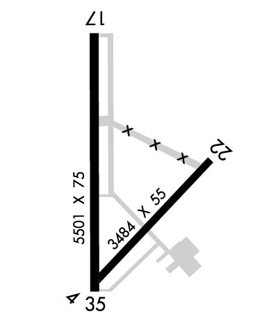
| Lat: N 3129.1 Long: W 09719.0 Elev: 592 Var: -06 Longest Runway: 5501 | ||
| Clr Del: 121.72 (GCO) AWOS: 135.52 CTAF: 123.05 | ||
| |||||||||||||||||||||||||||||||||||||||||||||||||||||||||||||||||||||
| |||||||||||||||||||||||||||||||||||||||||||||||||||||||||||||||||||||
| |||||||||||||||||||||||||||||||||||||||||||||||||||||||||||||||||||||
| Rwy | Rwy | |||||||
| 3484x55 | 3484' | 3484x55 | 3484' | |||||
| 5501x75 | 5501' | 5501x75 | 5501' | |||||
| Runway ID | Single Wheel | Double Wheel | Double Tandem Wheel | Dual Double Wheel |
| 04/22 | 12,000 | N/A | N/A | N/A |
| 17/35 | 30,000 | 50,000 | N/A | N/A |
| These numbers are Advisory and are not limits. The Airport Manager should have more accurate Weight Limits | ||||
 Airport Diagram might not be current. | |
| Facility Name: | MC GREGOR EXEC |
| City Name: | WACO |
| County: | MC LENNAN |
| State abbrev: | TX |
| State Name: | TEXAS |
| Ownership: | PUBLICLY OWNED |
| Use: | OPEN TO THE PUBLIC |
| Owner's Name: | CITY OF MCGREGOR |
| Address: | 302 S MADISON ST, P O BOX 192 |
| MC GREGOR, TX 76657 | |
| Owner's Phone: | 254-840-2806 |
| Manager's Name: | BARRY LIGHTFOOT |
| Address: | PO BOX 192 |
| MC GREGOR, TX 76657 | |
| Phone: | 254-848-5477; OR 254-848-2345. (FBO) 254-840-2855 (POLICE) |
| FAA Region: | SOUTHWEST |
| FAA Field Office: | TEX |
| Date | Sunrise | Sunset |
|---|---|---|
| 06/08/26 Monday | 6:24 | 20:33 |
| 06/09/26 Tuesday | 6:24 | 20:33 |
| 06/10/26 Wednesday | 6:24 | 20:34 |
| 06/11/26 Thursday | 6:24 | 20:34 |
| 06/12/26 Friday | 6:24 | 20:34 |
| 06/13/26 Saturday | 6:24 | 20:35 |
| 06/14/26 Sunday | 6:24 | 20:35 |
| 06/15/26 Monday | 6:24 | 20:35 |
| 06/16/26 Tuesday | 6:24 | 20:36 |
| 06/17/26 Wednesday | 6:24 | 20:36 |
| 06/18/26 Thursday | 6:24 | 20:36 |
| 06/19/26 Friday | 6:25 | 20:37 |
| 06/20/26 Saturday | 6:25 | 20:37 |
| 06/21/26 Sunday | 6:25 | 20:37 |
| Airport Attendance Schedule | 7 Days A Week 0700-1900 |
| Airport Status | OPERATIONAL (This Status can change at any time - please check NOTAMS) |
| Airport Lighting Schedule | ACTVT REIL RWY 17 - CTAF. MIRL RWY 17/35 PRESET LOW INTST; TO INCR INTST ACTVT - CTAF. |
| Airport Storage Available | Tie Downs, Hanger |
| Extra Services Available | Crop Dusting, Charter, Flight Instruction, Aircraft Rental, Aircraft Sales |
| Wind Indicator | YES - (lighted) |
| Control Tower | NO |
| CTAF Frequency | 123.050 |
| Unicom Frequency | 123.050 |
| Rotating Beacon Color | WG |
| Segmented Circle | YES |
| Landing Fee | NO |
| Airport Inspected | STATE - performed by PRIVATE CONTRACT PERSONNEL |
| Inspection Date | 05/20/2025 |
| Type of Fuel Available | Grade 100LL, JET A-1 (icing inhibitor, freeze point -50C); -10AFT HRS FUEL CALL 254-379-8204. CALL-IN FEE. MILITARY FUEL CONTRACT. |
| Airframe Repair Service | MAJOR |
| Power Plant Repair Service | MAJOR |
| Latitude | N3129.1 |
| Longitude | W09719.0 (ESTIMATED) |
| Arpt Elevation | 591ft (SURVEYED) |
| Magnetic Variation | 06E |
| 4 miles W | of WACO |
| Traffic Pattern Altitude | |
| Sectional Chart | SAN ANTONIO |
| Operations (Reported) | Yearly | Avg. Daily |
|---|---|---|
| General Aviation Transient | 0 | 0 |
| General Aviation Local | 0 | 0 |
| Air Taxi | 0 | 0 |
| Commerical | 0 | 0 |
| Commuter | 0 | 0 |
| Military | 0 | 0 |
| Aircraft based on Field | |
|---|---|
| General Aviation Singles | 0 |
| General Aviation Multi | 0 |
| Jet Aircraft | 0 |
| General Aviation Helicopters | 0 |
| Military Aircraft | 0 |
| Gliders | 0 |
| Ultralights | 0 |
| FSS on field | NO |
| FSS tie-in | FORT WORTH |
| FSS Phone | 1-800-WX-BRIEF |
| Who issues Notams | PWG |
| Notam D service at airport | YES |
| ARTCC Name | FORT WORTH |
| Airport Certification | |
| Aircraft Rescue & Firefighting Index | None |
| Airport of Entry | No |
| Custom Landing Rights | No |
| Joint Civil/Military | No |
| Military Landing rights | YES |
| NATIONAL PLAN OF INTEGRATED AIRPORT SYSTEMS (NPIAS) |
| GRANT AGREEMENTS UNDER FAAP/ADAP/AIP |
| SURPLUS PROPERTY AGREEMENT UNDER REGULATION 16-WAA |
| ASSURANCES PURSUANT TO TITLE VI, CIVIL RIGHTS ACT OF 1964 |
| THIS AIRPORT HAS BEEN SURVEYED BY THE NATIONAL GEODETIC SURVEY. |
| CALM WIND LESS THAN 5 KNOTS USE RWY 17. |
| 2550 FT MSL TWRS, 8 MILES SOUTH RWY 35 END. |
| FOR CD IF UNA VIA GCO CTC FORT WORTH ARTCC AT 817-858-7584. |
Airport Communications & Frequencies:
| |||||||||||||||||
| Runway: 04 | Runway: 22 | ||
| Mag heading: | 38° | Mag heading: | 218° |
| Rwy Slope: | .01% Up | Rwy Slope: | -.01% Down |
| Approach: | Approach: | ||
| Pattern: | Left Traffic | Pattern: | Left Traffic |
| Markings: | BASIC | Markings: | BASIC |
| Marking Condition: | GOOD | Marking Condition: | GOOD |
| Arresting Dev: | Arresting Dev: | ||
| Lat & Long: | N3128.8 W09719.1 | Lat. & Long.: | N3129.2 W09718.6 |
| Elev: | 567.6 ft. MSL | Elev: | 568.0 ft. MSL |
| TCH: | TCH: | ||
| Visual Glide Path: | Visual Glide Path: | ||
| Displaced Threshold: | No | Displaced Threshold: | No |
| Touchdown Zone: | YES | Touchdown Zone: | YES |
| Touchdown Elev.: | 571.0 feet | Touchdown Elev.: | 571.0 feet |
| Visual Glide Slope: | Visual Glide Slope: | ||
| RVR Equipment: | RVR Equipment: | ||
| RVV Equipment: | NO | RVV Equipment: | NO |
| Approach Lights: | Approach Lights: | ||
| REIL: | NO | REIL: | NO |
| Centerline Lights: | NO | Centerline Lights: | NO |
| Touchdown lights: | NO | Touchdown lights: | NO |
| Runway Category: | Runway with a Visual Approach | Runway Category: | Runway with a Visual Approach |
| Declared Distances: | Declared Distances: | ||
| Obstructions: | TREES | Obstructions: | |
| Marked: | NOT Marked/Lighted | Marked: | |
| Clearance slope: | 30:1 | Clearance slope: | 50:1 |
| Obstruction height: | 80 feet AGL | Obstruction height: | |
| Dist. from runway: | 2650 feet | Dist. from runway: | |
| Centerline offset: | 375 right of centerline | Centerline offset: | |
| Comments: | Comments: |
| Runway: 17 | Runway: 35 | ||
| Mag heading: | 173° | Mag heading: | 353° |
| Rwy Slope: | -.45% Down | Rwy Slope: | .45% Up |
| Approach: | Approach: | ||
| Pattern: | Left Traffic | Pattern: | Left Traffic |
| Markings: | NONPRECISION INSTRUMENT | Markings: | NONPRECISION INSTRUMENT |
| Marking Condition: | GOOD | Marking Condition: | GOOD |
| Arresting Dev: | Arresting Dev: | ||
| Lat & Long: | N3129.6 W09719.1 | Lat. & Long.: | N3128.7 W09719.1 |
| Elev: | 590.5 ft. MSL | Elev: | 566.0 ft. MSL |
| TCH: | 36 ft. AGL | TCH: | 46 ft. AGL |
| Visual Glide Path: | 3.00 degrees | Visual Glide Path: | 3.00 degrees |
| Displaced Threshold: | No | Displaced Threshold: | No |
| Touchdown Zone: | YES | Touchdown Zone: | YES |
| Touchdown Elev.: | 591.7 feet | Touchdown Elev.: | 580.4 feet |
| Visual Glide Slope: | 4-Light PAPI on LEFT side of Runway | Visual Glide Slope: | 4-Light PAPI on LEFT side of Runway |
| RVR Equipment: | RVR Equipment: | ||
| RVV Equipment: | NO | RVV Equipment: | NO |
| Approach Lights: | Approach Lights: | ||
| REIL: | YES | REIL: | NO |
| Centerline Lights: | NO | Centerline Lights: | NO |
| Touchdown lights: | NO | Touchdown lights: | NO |
| Runway Category: | D | Runway Category: | D |
| Declared Distances: | Declared Distances: | ||
| Obstructions: | TREES | Obstructions: | TREES |
| Marked: | NOT Marked/Lighted | Marked: | NOT Marked/Lighted |
| Clearance slope: | 28:1 | Clearance slope: | 23:1 |
| Obstruction height: | 32 feet AGL | Obstruction height: | 42 feet AGL |
| Dist. from runway: | 1100 feet | Dist. from runway: | 1200 feet |
| Centerline offset: | 235 right of centerline | Centerline offset: | 680 feet right of centerline |
| Comments: | Comments: |
Thanks for using FltPlan.com
all rights reserved © 1999-2026 by Flight Plan LLC