
| PLACERVILLE PLACERVILLE CA |
| |
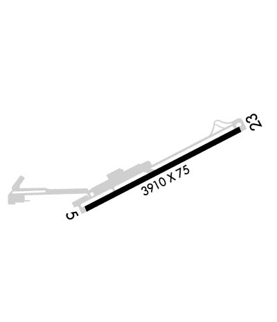
| Lat: N 3843.5 Long: W 12045.2 Elev: 2586 Var: -14 Longest Runway: 3914 | ||
| AWOS: 128.12 CTAF: 122.8 | ||
| ||||||||||||||||||||||||||||||||||||||||||||
| ||||||||||||||||||||||||||||||||||||||||||||
| ||||||||||||||||||||||||||||||||||||||||||||
| ||||||||||||||||||||||||||||||||||||||||||||
| Rwy | Rwy | |||||||
| 3914x76 | 3914' | 3914x76 | 3914' | |||||
| Runway ID | Single Wheel | Double Wheel | Double Tandem Wheel | Dual Double Wheel |
| 05/23 | 26,000 | N/A | N/A | N/A |
| H1 | N/A | N/A | N/A | N/A |
| These numbers are Advisory and are not limits. The Airport Manager should have more accurate Weight Limits | ||||
 Airport Diagram might not be current. | |
| Facility Name: | PLACERVILLE |
| City Name: | PLACERVILLE |
| County: | EL DORADO |
| State abbrev: | CA |
| State Name: | CALIFORNIA |
| Ownership: | PUBLICLY OWNED |
| Use: | OPEN TO THE PUBLIC |
| Owner's Name: | EL DORADO COUNTY |
| Address: | 2850 FAIRLANE COURT |
| PLACERVILLE, CA 95667 | |
| Owner's Phone: | (530) 622-0459 |
| Manager's Name: | SHERRIE BUSBY |
| Address: | 3501 AIRPORT RD. SUITE 1, SUITE 1 |
| PLACERVILLE, CA 95667 | |
| Phone: | 530-622-0459 |
| FAA Region: | WESTERN-PACIFIC |
| FAA Field Office: | SFO |

| Date | Sunrise | Sunset |
|---|---|---|
| 09/24/21 Friday | 6:52 | 18:57 |
| 09/25/21 Saturday | 6:53 | 18:55 |
| 09/26/21 Sunday | 6:54 | 18:54 |
| 09/27/21 Monday | 6:55 | 18:52 |
| 09/28/21 Tuesday | 6:56 | 18:51 |
| 09/29/21 Wednesday | 6:57 | 18:49 |
| 09/30/21 Thursday | 6:58 | 18:48 |
| 10/01/21 Friday | 6:59 | 18:46 |
| 10/02/21 Saturday | 7:00 | 18:44 |
| 10/03/21 Sunday | 7:01 | 18:43 |
| 10/04/21 Monday | 7:02 | 18:41 |
| 10/05/21 Tuesday | 7:02 | 18:40 |
| 10/06/21 Wednesday | 7:03 | 18:38 |
| 10/07/21 Thursday | 7:04 | 18:37 |
| Airport Attendance Schedule | 7 Days A Week 0800-1700 |
| Airport Status | OPERATIONAL (This Status can change at any time - please check NOTAMS) |
| Airport Lighting Schedule | ACTVT VASI RWY 05; PAPI RWY 23; MIRL RWY 05/23 - CTAF. |
| Airport Storage Available | Tie Downs |
| Extra Services Available | Flight Instruction, Aircraft Rental, Aircraft Sales |
| Wind Indicator | YES - (lighted) |
| Control Tower | NO |
| CTAF Frequency | 122.800 |
| Unicom Frequency | 122.800 |
| Rotating Beacon Color | CLEAR-GREEN (Light Land Airport) |
| Segmented Circle | YES |
| Landing Fee | NO |
| Airport Inspected | STATE - performed by STATE AERONAUTICAL PERSONNEL |
| Inspection Date | 08/23/2018 |
| Type of Fuel Available | Grade 100LL, JET A (freeze point -40C); -10FUEL AVBL 24 HOURS BY CREDIT CARD. |
| Airframe Repair Service | MAJOR |
| Power Plant Repair Service | MAJOR |
| Latitude | N3843.5 |
| Longitude | W12045.2 (ESTIMATED) |
| Arpt Elevation | 2585ft (SURVEYED) |
| Magnetic Variation | 14E |
| 3 miles E | of PLACERVILLE |
| Traffic Pattern Altitude | 800 |
| Sectional Chart | SAN FRANCISCO |
| Operations (Reported) | Yearly | Avg. Daily |
|---|---|---|
| General Aviation Transient | 30600 | 84 |
| General Aviation Local | 27000 | 74 |
| Air Taxi | 900 | 2 |
| Commerical | 0 | 0 |
| Commuter | 0 | 0 |
| Military | 900 | 2 |
| Aircraft based on Field | |
|---|---|
| General Aviation Singles | 58 |
| General Aviation Multi | 0 |
| Jet Aircraft | 0 |
| General Aviation Helicopters | 0 |
| Military Aircraft | 0 |
| Gliders | 1 |
| Ultralights | 0 |
| FSS on field | NO |
| FSS tie-in | RANCHO MURIETA |
| FSS Phone | 1-800-WX-BRIEF |
| Who issues Notams | RIU |
| Notam D service at airport | YES |
| ARTCC Name | OAKLAND |
| Airport Certification | |
| Aircraft Rescue & Firefighting Index | None |
| Airport of Entry | No |
| Custom Landing Rights | No |
| Joint Civil/Military | No |
| Military Landing rights | YES |
| NATIONAL PLAN OF INTEGRATED AIRPORT SYSTEMS (NPIAS) |
| GRANT AGREEMENTS UNDER FAAP/ADAP/AIP |
| ASSURANCES PURSUANT TO TITLE VI, CIVIL RIGHTS ACT OF 1964 |
| TREES 750 FT N RWY 5/23 2697 FT MSL (110FT AGL) NOT LGTD. |
| FOR CD CTC NORCAL APCH AT 916-361-6874. |
| PPR FOR TGL FOR ACFT OVER 12500 LBS. |
| HELO PARKING AT NE END OF RY. |
| NOISE ABATEMENT PROCEDURE: NO MID-FIELD DEPS; NO TURNS WEST OR NORTH PRIOR TO 3400 MSL OR CLEAR OF NOISE SENSITIVE AREA. RY 23 AFTER TKOF MAKE 10 DEG LEFT TURN AT EOR TO AVOID NOISE SENSITIVE RESIDENTIAL AREAS. |
| DEER ON AND INVOF RY ESPECIALLY NGTS. |
| HELIPAD LCTD ON NORTH SIDE OF RY 05 END. |
Airport Communications & Frequencies:
| |||||||||||||||||
| Runway: 05 | Runway: 23 | ||
| Mag heading: | 48° | Mag heading: | 228° |
| Rwy Slope: | .04% Up | Rwy Slope: | -.04% Down |
| Approach: | Approach: | ||
| Pattern: | Right Traffic | Pattern: | Left Traffic |
| Markings: | NONPRECISION INSTRUMENT | Markings: | NONPRECISION INSTRUMENT |
| Marking Condition: | FAIR | Marking Condition: | FAIR |
| Arresting Dev: | Arresting Dev: | ||
| Lat & Long: | N3843.3 W12045.6 | Lat. & Long.: | N3843.6 W12044.8 |
| Elev: | 2580.5 ft. MSL | Elev: | 2582.2 ft. MSL |
| TCH: | 22 ft. AGL | TCH: | 28 ft. AGL |
| Visual Glide Path: | 3.00 degrees | Visual Glide Path: | 3.75 degrees |
| Displaced Threshold: | No | Displaced Threshold: | No |
| Touchdown Zone: | YES | Touchdown Zone: | YES |
| Touchdown Elev.: | 2585.7 feet | Touchdown Elev.: | 2585.8 feet |
| Visual Glide Slope: | 4-BOX VASI ON LEFT SIDE OF RUNWAY | Visual Glide Slope: | 2-Light PAPI on LEFT side of Runway |
| RVR Equipment: | RVR Equipment: | ||
| RVV Equipment: | NO | RVV Equipment: | NO |
| Approach Lights: | Approach Lights: | ||
| REIL: | NO | REIL: | NO |
| Centerline Lights: | NO | Centerline Lights: | NO |
| Touchdown lights: | NO | Touchdown lights: | NO |
| Runway Category: | Runway with a Non-precision Approach | Runway Category: | Runway with a Visual Approach |
| Declared Distances: | Declared Distances: |
Thanks for using FltPlan.com
all rights reserved © 1999-2021 by Flight Plan LLC