
| BEECH RIVER RGNL LEXINGTON-PARSONS TN |
| |
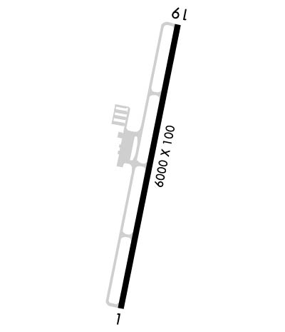
| Lat: N 3539.4 Long: W 08811.7 Elev: 488 Var: +01 Longest Runway: 6000 | ||
| AWOS: 118.12 CTAF: 123.0 | ||
| ||||||
| ||||||
|
| Rwy | Rwy | |||||||
| 6000x100 | 6000' | 6000x100 | 6000' | |||||
| Runway ID | Single Wheel | Double Wheel | Double Tandem Wheel | Dual Double Wheel |
| 01/19 | 45,000 | 60,000 | N/A | N/A |
| These numbers are Advisory and are not limits. The Airport Manager should have more accurate Weight Limits | ||||
 Airport Diagram might not be current. | |
| Facility Name: | BEECH RIVER RGNL |
| City Name: | LEXINGTON-PARSONS |
| County: | HENDERSON |
| State abbrev: | TN |
| State Name: | TENNESSEE |
| Ownership: | PUBLICLY OWNED |
| Use: | OPEN TO THE PUBLIC |
| Owner's Name: | BEECH RIVER REGIONAL ARPT AUTHORITY |
| Address: | 1600 MT ARARAT ROAD |
| DARDEN, TN 38328 | |
| Owner's Phone: | 731-845-5740; 731-845-4937 |
| Manager's Name: | KEITH COTTON |
| Address: | 1600 MT ARARAT ROAD |
| DARDEN, TN 32328 | |
| Phone: | 731-845-4937; 731-845-5740 |
| FAA Region: | SOUTHERN |
| FAA Field Office: | MEM |
| Date | Sunrise | Sunset |
|---|---|---|
| 09/24/21 Friday | 6:42 | 18:47 |
| 09/25/21 Saturday | 6:43 | 18:46 |
| 09/26/21 Sunday | 6:44 | 18:44 |
| 09/27/21 Monday | 6:44 | 18:43 |
| 09/28/21 Tuesday | 6:45 | 18:41 |
| 09/29/21 Wednesday | 6:46 | 18:40 |
| 09/30/21 Thursday | 6:47 | 18:38 |
| 10/01/21 Friday | 6:48 | 18:37 |
| 10/02/21 Saturday | 6:48 | 18:35 |
| 10/03/21 Sunday | 6:49 | 18:34 |
| 10/04/21 Monday | 6:50 | 18:33 |
| 10/05/21 Tuesday | 6:51 | 18:31 |
| 10/06/21 Wednesday | 6:52 | 18:30 |
| 10/07/21 Thursday | 6:52 | 18:28 |
| Airport Attendance Schedule | MON-SAT 0800-1700; CLSD THANKSGIVING, CHRISTMAS, EASTER AND NEW YEARS DAY. |
| Airport Status | OPERATIONAL (This Status can change at any time - please check NOTAMS) |
| Airport Lighting Schedule | ACTVT REIL RWY 01 & 19; MIRL RWY 01/19 - CTAF. PAPI RWY 01 & 19 OPR CONSLY. |
| Airport Storage Available | Tie Downs, Hanger |
| Extra Services Available | Flight Instruction |
| Wind Indicator | YES - (lighted) |
| Control Tower | NO |
| CTAF Frequency | 123.000 |
| Unicom Frequency | 123.000 |
| Rotating Beacon Color | CLEAR-GREEN (Light Land Airport) |
| Segmented Circle | YES |
| Landing Fee |
| Airport Inspected | 5010-1 PUBLIC USE MAILOUT PROGRAM - performed by STATE AERONAUTICAL PERSONNEL |
| Inspection Date | 08/12/2020 |
| Type of Fuel Available | Grade 100LL, JET A; -10FUEL 24 HR CREDIT CARD SVC AVBL. |
| Airframe Repair Service | MAJOR |
| Power Plant Repair Service | MAJOR |
| Latitude | N3539.4 |
| Longitude | W08811.7 (ESTIMATED) |
| Arpt Elevation | 487ft (SURVEYED) |
| Magnetic Variation | 01W |
| 5 miles NW | of LEXINGTON-PARSONS |
| Traffic Pattern Altitude | |
| Sectional Chart | MEMPHIS |
| Operations (Reported) | Yearly | Avg. Daily |
|---|---|---|
| General Aviation Transient | 1200 | 3 |
| General Aviation Local | 2000 | 5 |
| Air Taxi | 100 | 0 |
| Commerical | 0 | 0 |
| Commuter | 0 | 0 |
| Military | 100 | 0 |
| Aircraft based on Field | |
|---|---|
| General Aviation Singles | 18 |
| General Aviation Multi | 3 |
| Jet Aircraft | 2 |
| General Aviation Helicopters | 0 |
| Military Aircraft | 0 |
| Gliders | 0 |
| Ultralights | 0 |
| FSS on field | NO |
| FSS tie-in | JACKSON |
| FSS Phone | 1-800-WX-BRIEF |
| Who issues Notams | MKL |
| Notam D service at airport | YES |
| ARTCC Name | MEMPHIS |
| Airport Certification | |
| Aircraft Rescue & Firefighting Index | None |
| Airport of Entry | No |
| Custom Landing Rights | No |
| Joint Civil/Military | No |
| Military Landing rights | No |
| NATIONAL PLAN OF INTEGRATED AIRPORT SYSTEMS (NPIAS) |
| FOR CD CTC MEMPHIS ARTCC AT 901-368-8453/8449. |
Airport Communications & Frequencies:
| |||||||||
| Runway: 01 | Runway: 19 | ||
| Mag heading: | 13° | Mag heading: | 193° |
| Rwy Slope: | .70% Up | Rwy Slope: | -.70% Down |
| Approach: | Approach: | ||
| Pattern: | Left Traffic | Pattern: | Left Traffic |
| Markings: | NONPRECISION INSTRUMENT | Markings: | NONPRECISION INSTRUMENT |
| Marking Condition: | GOOD | Marking Condition: | GOOD |
| Arresting Dev: | Arresting Dev: | ||
| Lat & Long: | N3538.9 W08811.8 | Lat. & Long.: | N3539.9 W08811.6 |
| Elev: | 445.7 ft. MSL | Elev: | 487.7 ft. MSL |
| TCH: | 32 ft. AGL | TCH: | 35 ft. AGL |
| Visual Glide Path: | 3.09 degrees | Visual Glide Path: | 3.29 degrees |
| Displaced Threshold: | No | Displaced Threshold: | No |
| Touchdown Zone: | YES | Touchdown Zone: | YES |
| Touchdown Elev.: | 466.6 feet | Touchdown Elev.: | 487.7 feet |
| Visual Glide Slope: | 2-Light PAPI on LEFT side of Runway | Visual Glide Slope: | 2-Light PAPI on LEFT side of Runway |
| RVR Equipment: | RVR Equipment: | ||
| RVV Equipment: | NO | RVV Equipment: | NO |
| Approach Lights: | Approach Lights: | ||
| REIL: | YES | REIL: | YES |
| Centerline Lights: | NO | Centerline Lights: | NO |
| Touchdown lights: | NO | Touchdown lights: | NO |
| Runway Category: | Runway with a Non-precision Approach having visibility minimums greater than 3/4 mile | Runway Category: | Runway with a Non-precision Approach having visibility minimums greater than 3/4 mile |
| Declared Distances: | Declared Distances: |
Thanks for using FltPlan.com
all rights reserved © 1999-2021 by Flight Plan LLC