| PROVINCETOWN MUNI PROVINCETOWN MA |
| |
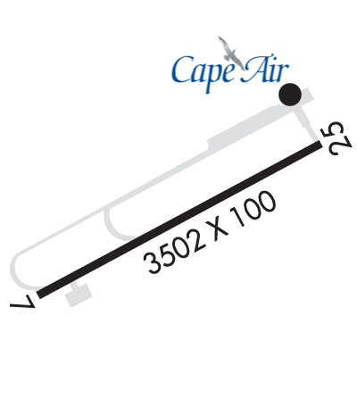
| Lat: N 4204.3 Long: W 07013.2 Elev: 8 Var: +16 Longest Runway: 3502 | ||
| Clr Del: 120.65 AWOS: 119.02 CTAF: 122.8 | ||
| |||||||||||||||||||||||||||||||||||||||||||||||||||||||||||||
| |||||||||||||||||||||||||||||||||||||||||||||||||||||||||||||
| |||||||||||||||||||||||||||||||||||||||||||||||||||||||||||||
| Rwy | Rwy | |||||||
| 3502x100 | 3502' | 111.10 - 075° | 3502x100 | 3502' | ||||
| Runway ID | Single Wheel | Double Wheel | Double Tandem Wheel | Dual Double Wheel |
| 07/25 | 25,000 | N/A | N/A | N/A |
| These numbers are Advisory and are not limits. The Airport Manager should have more accurate Weight Limits | ||||
 Airport Diagram might not be current. | |
| Facility Name: | PROVINCETOWN MUNI |
| City Name: | PROVINCETOWN |
| County: | BARNSTABLE |
| State abbrev: | MA |
| State Name: | MASSACHUSETTS |
| Ownership: | PUBLICLY OWNED |
| Use: | OPEN TO THE PUBLIC |
| Owner's Name: | DEPT OF INTERIOR NATL PARK SERVICE |
| Address: | CAPE COD NATIONAL SEASHORE |
| SOUTH WELLFLEET, MA 02663 | |
| Owner's Phone: | 508-487-2100 |
| Manager's Name: | PETER KACERGIS |
| Address: | PROVINCETOWN AIRPORT |
| PROVINCETOWN, MA 02657 | |
| Phone: | 508-487-0241 |
| FAA Region: | NEW ENGLAND |
| FAA Field Office: | NONE |
| Date | Sunrise | Sunset |
|---|---|---|
| 09/24/21 Friday | 6:30 | 18:35 |
| 09/25/21 Saturday | 6:31 | 18:33 |
| 09/26/21 Sunday | 6:32 | 18:32 |
| 09/27/21 Monday | 6:33 | 18:30 |
| 09/28/21 Tuesday | 6:34 | 18:28 |
| 09/29/21 Wednesday | 6:35 | 18:26 |
| 09/30/21 Thursday | 6:36 | 18:25 |
| 10/01/21 Friday | 6:38 | 18:23 |
| 10/02/21 Saturday | 6:39 | 18:21 |
| 10/03/21 Sunday | 6:40 | 18:19 |
| 10/04/21 Monday | 6:41 | 18:18 |
| 10/05/21 Tuesday | 6:42 | 18:16 |
| 10/06/21 Wednesday | 6:43 | 18:14 |
| 10/07/21 Thursday | 6:44 | 18:13 |
| Airport Attendance Schedule | MAY-OCT 7 Days A Week DALGT, NOV-APR MON-SAT 0600-1800, NOV-APR SUN 1100-1830 |
| Airport Status | OPERATIONAL (This Status can change at any time - please check NOTAMS) |
| Airport Lighting Schedule | ACTVT MALSF RWY 07; PAPI RWY 07 & 25; HIRL RWY 07/25 - 122.85. |
| Airport Storage Available | Tie Downs |
| Extra Services Available | Charter |
| Wind Indicator | YES - (unlit) |
| Control Tower | NO |
| CTAF Frequency | 122.800 |
| Unicom Frequency | 122.800 |
| Rotating Beacon Color | CLEAR-GREEN (Light Land Airport) |
| Segmented Circle | YES |
| Landing Fee | PRKG FEE. |
| Airport Inspected | STATE - performed by STATE AERONAUTICAL PERSONNEL |
| Inspection Date | 02/25/2020 |
| Type of Fuel Available | Grade 100LL; -10FOR AVBLTY - AMGR. |
| Airframe Repair Service | NONE |
| Power Plant Repair Service | NONE |
| Latitude | N4204.3 |
| Longitude | W07013.2 (ESTIMATED) |
| Arpt Elevation | 7ft (SURVEYED) |
| Magnetic Variation | 16W |
| 2 miles NW | of PROVINCETOWN |
| Traffic Pattern Altitude | |
| Sectional Chart | NEW YORK |
| Operations (Reported) | Yearly | Avg. Daily |
|---|---|---|
| General Aviation Transient | 42200 | 116 |
| General Aviation Local | 2200 | 6 |
| Air Taxi | 950 | 3 |
| Commerical | 4400 | 12 |
| Commuter | 0 | 0 |
| Military | 80 | 0 |
| Aircraft based on Field | |
|---|---|
| General Aviation Singles | 5 |
| General Aviation Multi | 0 |
| Jet Aircraft | 0 |
| General Aviation Helicopters | 0 |
| Military Aircraft | 0 |
| Gliders | 0 |
| Ultralights | 0; ULTRALIGHT OPS NA MAY 1 - SEP 30. |
| FSS on field | NO |
| FSS tie-in | BRIDGEPORT |
| FSS Phone | 1-800-WX-BRIEF |
| Who issues Notams | PVC |
| Notam D service at airport | YES |
| ARTCC Name | BOSTON |
| Airport Certification | |
| Aircraft Rescue & Firefighting Index | None |
| Airport of Entry | No |
| Custom Landing Rights | No |
| Joint Civil/Military | No |
| Military Landing rights | YES |
| NATIONAL PLAN OF INTEGRATED AIRPORT SYSTEMS (NPIAS) |
| GRANT AGREEMENTS UNDER FAAP/ADAP/AIP |
| ASSURANCES PURSUANT TO TITLE VI, CIVIL RIGHTS ACT OF 1964 |
| THIS AIRPORT HAS BEEN SURVEYED BY THE NATIONAL GEODETIC SURVEY. |
| WILDLIFE ON & INVOF ARPT. |
| CTN: HIGH SPD MIL & HEL TFC INVOF CAPE COD CGAS. |
| SAWRS. |
| FOR CD CTC BOSTON APCH AT 603-594-5554. |
Airport Communications & Frequencies:
| |||||||||||||||
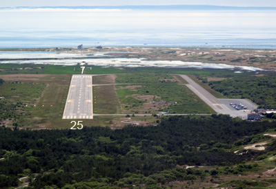
| Runway: 07 | Runway: 25 | ||
| Mag heading: | 75° | Mag heading: | 255° |
| Rwy Slope: | .01% Up | Rwy Slope: | -.01% Down |
| Approach: | ILS/DME | Approach: | |
| Pattern: | Left Traffic | Pattern: | Right Traffic |
| Markings: | PRECISION INSTRUMENT | Markings: | PRECISION INSTRUMENT |
| Marking Condition: | GOOD | Marking Condition: | GOOD |
| Arresting Dev: | Arresting Dev: | ||
| Lat & Long: | N4204.2 W07013.6 | Lat. & Long.: | N4204.5 W07012.9 |
| Elev: | 7.6 ft. MSL | Elev: | 7.8 ft. MSL |
| TCH: | 40 ft. AGL | TCH: | 40 ft. AGL |
| Visual Glide Path: | 3.00 degrees | Visual Glide Path: | 3.00 degrees |
| Displaced Threshold: | No | Displaced Threshold: | No |
| Touchdown Zone: | YES | Touchdown Zone: | YES |
| Touchdown Elev.: | 7.8 feet | Touchdown Elev.: | 7.8 feet |
| Visual Glide Slope: | 4-Light PAPI on RIGHT side of Runway | Visual Glide Slope: | 4-Light PAPI on LEFT side of Runway |
| RVR Equipment: | RVR Equipment: | ||
| RVV Equipment: | NO | RVV Equipment: | NO |
| Approach Lights: | MALSF - 1,400 foot medium intensity approach lighting system with sequenced flashers | Approach Lights: | |
| REIL: | NO | REIL: | YES |
| Centerline Lights: | NO | Centerline Lights: | NO |
| Touchdown lights: | NO | Touchdown lights: | NO |
| Runway Category: | Precision Instrument Runway | Runway Category: | Runway with a Non-precision Approach having visibility minimums greater than 3/4 mile |
| Declared Distances: | Declared Distances: | ||
| Obstructions: | Obstructions: | TREES | |
| Marked: | Marked: | NOT Marked/Lighted | |
| Clearance slope: | 50:1 | Clearance slope: | 34:1 |
| Obstruction height: | Obstruction height: | 12 feet AGL | |
| Dist. from runway: | Dist. from runway: | 610 feet | |
| Centerline offset: | Centerline offset: | 125 feet left of centerline | |
| Comments: | Comments: |
Thanks for using FltPlan.com
all rights reserved © 1999-2021 by Flight Plan LLC