
| CARBON COUNTY REGIONAL PRICE UT |
| |
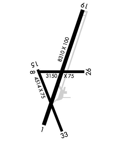
| Lat: N 3936.8 Long: W 11045.1 Elev: 5958 Var: -11 Longest Runway: 8316 | ||
| AWOS: 135.42 CTAF: 122.8 | ||
| ||||||||||||||||||||||||||||||||||||||||||||
| ||||||||||||||||||||||||||||||||||||||||||||
| ||||||||||||||||||||||||||||||||||||||||||||
| Rwy | Rwy | |||||||
| 8316x100 | 8316' | 109.35 - 007° | 8316x100 | 8316' | ||||
| 3151x75 | 3023' | 3151x75 | 3151' | |||||
| 4513x75 | 4513' | 4513x75 | 4513' | |||||
| Runway ID | Single Wheel | Double Wheel | Double Tandem Wheel | Dual Double Wheel |
| 01/19 | 30,000 | 40,000 | N/A | N/A |
| 08/26 | 12,500 | N/A | N/A | N/A |
| 15/33 | 13,000 | N/A | N/A | N/A |
| These numbers are Advisory and are not limits. The Airport Manager should have more accurate Weight Limits | ||||
 Airport Diagram might not be current. | |
| Facility Name: | CARBON COUNTY RGNL/BUCK DAVIS FLD |
| City Name: | PRICE |
| County: | CARBON |
| State abbrev: | UT |
| State Name: | UTAH |
| Ownership: | PUBLICLY OWNED |
| Use: | OPEN TO THE PUBLIC |
| Owner's Name: | CARBON COUNTY |
| Address: | 120 E MAIN ST. |
| PRICE, UT 84501 | |
| Owner's Phone: | 435-636-3201 |
| Manager's Name: | ANGIE JOHANNSEN |
| Address: | P.O.BOX 786, 3095 EAST AIRPORT ROAD |
| PRICE, UT 84501 | |
| Phone: | 435-637-9556 |
| FAA Region: | NORTHWEST MOUNTAIN |
| FAA Field Office: | DEN |
| Date | Sunrise | Sunset |
|---|---|---|
| 09/24/21 Friday | 7:12 | 19:17 |
| 09/25/21 Saturday | 7:13 | 19:15 |
| 09/26/21 Sunday | 7:14 | 19:14 |
| 09/27/21 Monday | 7:15 | 19:12 |
| 09/28/21 Tuesday | 7:16 | 19:11 |
| 09/29/21 Wednesday | 7:17 | 19:09 |
| 09/30/21 Thursday | 7:18 | 19:07 |
| 10/01/21 Friday | 7:19 | 19:06 |
| 10/02/21 Saturday | 7:20 | 19:04 |
| 10/03/21 Sunday | 7:21 | 19:03 |
| 10/04/21 Monday | 7:22 | 19:01 |
| 10/05/21 Tuesday | 7:23 | 18:59 |
| 10/06/21 Wednesday | 7:24 | 18:58 |
| 10/07/21 Thursday | 7:25 | 18:56 |
| Airport Attendance Schedule | MON-FRI 0800-1600, SAT-SUN CLSD |
| Airport Status | OPERATIONAL (This Status can change at any time - please check NOTAMS) |
| Airport Lighting Schedule | ACTVT MALSF RWY 01; REIL RWY 19, 08 & 26; PAPI RWY 01 & 19, 08 & 26; HIRL RWY 01/19; MIRL RWY 15/33 - CTAF. |
| Airport Storage Available | Tie Downs, Hanger |
| Extra Services Available | Charter, Flight Instruction, Aircraft Rental |
| Wind Indicator | YES - (unlit) |
| Control Tower | NO |
| CTAF Frequency | 122.800 |
| Unicom Frequency | 122.800 |
| Rotating Beacon Color | CLEAR-GREEN (Light Land Airport) |
| Segmented Circle | NO |
| Landing Fee | NO |
| Airport Inspected | STATE - performed by STATE AERONAUTICAL PERSONNEL |
| Inspection Date | 06/03/2015 |
| Type of Fuel Available | Grade 100LL, JET A (freeze point -40C); -1024 HR SELF SVC FUEL AVBL WITH CREDIT CARD. |
| Airframe Repair Service | MINOR |
| Power Plant Repair Service | MINOR |
| Latitude | N3936.8 |
| Longitude | W11045.1 (ESTIMATED) |
| Arpt Elevation | 5957ft (SURVEYED) |
| Magnetic Variation | 11E |
| 3 miles E | of PRICE |
| Traffic Pattern Altitude | |
| Sectional Chart | DENVER |
| Operations (Reported) | Yearly | Avg. Daily |
|---|---|---|
| General Aviation Transient | 1698 | 5 |
| General Aviation Local | 1533 | 4 |
| Air Taxi | 1200 | 3 |
| Commerical | 0 | 0 |
| Commuter | 0 | 0 |
| Military | 0 | 0 |
| Aircraft based on Field | |
|---|---|
| General Aviation Singles | 12 |
| General Aviation Multi | 1 |
| Jet Aircraft | 0 |
| General Aviation Helicopters | 0 |
| Military Aircraft | 0 |
| Gliders | 0 |
| Ultralights | 0 |
| FSS on field | NO |
| FSS tie-in | CEDAR CITY |
| FSS Phone | 1-800-WX-BRIEF |
| Who issues Notams | PUC |
| Notam D service at airport | YES |
| ARTCC Name | SALT LAKE CITY |
| Airport Certification | |
| Aircraft Rescue & Firefighting Index | None |
| Airport of Entry | No |
| Custom Landing Rights | No |
| Joint Civil/Military | No |
| Military Landing rights | YES |
| NATIONAL PLAN OF INTEGRATED AIRPORT SYSTEMS (NPIAS) |
| GRANT AGREEMENTS UNDER FAAP/ADAP/AIP |
| CONVEYANCE UNDER SCETION 16, FEDERAL AIRPORT ACT OF 1946 OR SECTION 23, AIRPORT AND AIRWAY DEVELOPMENT ACT OF 1970 |
| ASSURANCES PURSUANT TO TITLE VI, CIVIL RIGHTS ACT OF 1964 |
| FOR CD IF UNA TO CTC ON FSS FREQ, CTC SALT LAKE ARTCC AT 801-320-2568. |
| RWY 01/1 9 SFC GROOVED. |
Airport Communications & Frequencies:
| |||||||||
| Runway: 01 | Runway: 19 | ||
| Mag heading: | 7° | Mag heading: | 187° |
| Rwy Slope: | 1.75% Up | Rwy Slope: | -1.75% Down |
| Approach: | ILS/DME | Approach: | |
| Pattern: | Left Traffic | Pattern: | Left Traffic |
| Markings: | PRECISION INSTRUMENT | Markings: | BASIC |
| Marking Condition: | GOOD | Marking Condition: | GOOD |
| Arresting Dev: | Arresting Dev: | ||
| Lat & Long: | N3936.3 W11045.3 | Lat. & Long.: | N3937.6 W11044.8 |
| Elev: | 5811.7 ft. MSL | Elev: | 5957.6 ft. MSL |
| TCH: | 52 ft. AGL | TCH: | 45 ft. AGL |
| Visual Glide Path: | 3.00 degrees | Visual Glide Path: | 4.00 degrees |
| Displaced Threshold: | No | Displaced Threshold: | No |
| Touchdown Zone: | YES | Touchdown Zone: | YES |
| Touchdown Elev.: | 5862.4 feet | Touchdown Elev.: | 5957.6 feet |
| Visual Glide Slope: | 4-Light PAPI on LEFT side of Runway | Visual Glide Slope: | 2-Light PAPI on LEFT side of Runway; PAPI UNUSBL BYD 3 NM DUE TO TRRN; BYD 9 DEGS RIGHT OF CNTRLN. |
| RVR Equipment: | RVR Equipment: | ||
| RVV Equipment: | NO | RVV Equipment: | NO |
| Approach Lights: | MALSF - 1,400 foot medium intensity approach lighting system with sequenced flashers | Approach Lights: | |
| REIL: | NO | REIL: | YES |
| Centerline Lights: | NO | Centerline Lights: | NO |
| Touchdown lights: | NO | Touchdown lights: | NO |
| Runway Category: | Precision Instrument Runway | Runway Category: | Runway with a Visual Approach |
| Declared Distances: | Declared Distances: | ||
| Obstructions: | Obstructions: | RWY 19 HIGH VOLTAGE TRANS LINE ON EXTDD CNTRLN. | |
| Marked: | Marked: | NOT Marked/Lighted | |
| Clearance slope: | 50:1 | Clearance slope: | 20:1 |
| Obstruction height: | Obstruction height: | ||
| Dist. from runway: | Dist. from runway: | ||
| Centerline offset: | Centerline offset: | ||
| Comments: | Comments: |
| Runway: 08 | Runway: 26 | ||
| Mag heading: | 79° | Mag heading: | 259° |
| Rwy Slope: | .99% Up | Rwy Slope: | -.99% Down |
| Approach: | Approach: | ||
| Pattern: | Left Traffic | Pattern: | Left Traffic |
| Markings: | BASIC | Markings: | BASIC |
| Marking Condition: | GOOD | Marking Condition: | GOOD |
| Arresting Dev: | Arresting Dev: | ||
| Lat & Long: | N3936.9 W11045.4 | Lat. & Long.: | N3936.9 W11044.7 |
| Elev: | 5859.3 ft. MSL | Elev: | 5890.5 ft. MSL |
| TCH: | 37 ft. AGL | TCH: | 40 ft. AGL |
| Visual Glide Path: | 3.00 degrees | Visual Glide Path: | 3.00 degrees |
| Displaced Threshold: | 128 feet | Displaced Threshold: | No |
| Touchdown Zone: | YES | Touchdown Zone: | YES |
| Touchdown Elev.: | 5890.4 feet | Touchdown Elev.: | 5890.5 feet |
| Visual Glide Slope: | 2-Light PAPI on LEFT side of Runway | Visual Glide Slope: | 2-Light PAPI on LEFT side of Runway |
| RVR Equipment: | RVR Equipment: | ||
| RVV Equipment: | NO | RVV Equipment: | NO |
| Approach Lights: | Approach Lights: | ||
| REIL: | YES | REIL: | YES |
| Centerline Lights: | NO | Centerline Lights: | NO |
| Touchdown lights: | NO | Touchdown lights: | NO |
| Runway Category: | Runway with a Visual Approach | Runway Category: | Runway with a Visual Approach |
| Declared Distances: | Declared Distances: | ||
| Obstructions: | 60 FT DROP OFF 520 FT FM RWY END. | Obstructions: | ROAD |
| Marked: | NOT Marked/Lighted | Marked: | NOT Marked/Lighted |
| Clearance slope: | 50:1 | Clearance slope: | 18:1 |
| Obstruction height: | Obstruction height: | ||
| Dist. from runway: | Dist. from runway: | ||
| Centerline offset: | Centerline offset: | ||
| Comments: | Comments: |
| Runway: 15 | Runway: 33 | ||
| Mag heading: | 147° | Mag heading: | 327° |
| Rwy Slope: | -1.06% Down | Rwy Slope: | 1.06% Up |
| Approach: | Approach: | ||
| Pattern: | Left Traffic | Pattern: | Left Traffic |
| Markings: | BASIC | Markings: | BASIC |
| Marking Condition: | FAIR | Marking Condition: | FAIR |
| Arresting Dev: | Arresting Dev: | ||
| Lat & Long: | N3936.9 W11045.4 | Lat. & Long.: | N3936.2 W11045.1 |
| Elev: | 5860.6 ft. MSL | Elev: | 5812.6 ft. MSL |
| TCH: | TCH: | ||
| Visual Glide Path: | Visual Glide Path: | ||
| Displaced Threshold: | No | Displaced Threshold: | No |
| Touchdown Zone: | YES | Touchdown Zone: | YES |
| Touchdown Elev.: | 5860.7 feet | Touchdown Elev.: | 5847.3 feet |
| Visual Glide Slope: | Visual Glide Slope: | ||
| RVR Equipment: | RVR Equipment: | ||
| RVV Equipment: | NO | RVV Equipment: | NO |
| Approach Lights: | Approach Lights: | ||
| REIL: | NO | REIL: | NO |
| Centerline Lights: | NO | Centerline Lights: | NO |
| Touchdown lights: | NO | Touchdown lights: | NO |
| Runway Category: | Runway with a Visual Approach | Runway Category: | Runway with a Visual Approach |
| Declared Distances: | Declared Distances: | ||
| Obstructions: | 20 FT DROP OFF 200 FT FM THLD. | Obstructions: | ROAD |
| Marked: | NOT Marked/Lighted | Marked: | NOT Marked/Lighted |
| Clearance slope: | 50:1 | Clearance slope: | 20:1 |
| Obstruction height: | Obstruction height: | ||
| Dist. from runway: | Dist. from runway: | ||
| Centerline offset: | Centerline offset: | ||
| Comments: | Comments: |
Thanks for using FltPlan.com
all rights reserved © 1999-2021 by Flight Plan LLC
