| PUEBLO MEMORIAL PUEBLO CO |
| |
| Lat: N 3817.4 Long: W 10429.9 Elev: 4729 Var: -08 Longest Runway: 10498 | ||
| Clr Del: 120.9 Dept. ATIS: 125.25 Arr. ATIS: 125.25 Ground: 121.9 Tower: 119.1 | ||
| |||||||||||||||||||||||||||||||||||||||||||||||||||||||||||||
| |||||||||||||||||||||||||||||||||||||||||||||||||||||||||||||
| |||||||||||||||||||||||||||||||||||||||||||||||||||||||||||||
| |||||||||||||||||||||||||||||||||||||||||||||||||||||||||||||
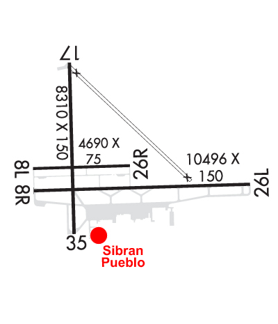
| Rwy | Rwy | |||||||
| 4690x75 | 4690' | 4690x75 | 4690' | |||||
| 10498x150 | 10498' | 109.50 - 080° | 10498x150 | 10498' | 108.30 - 260° | |||
| 8310x150 | 8310' | 8310x150 | 8310' | |||||
| Runway ID | Single Wheel | Double Wheel | Double Tandem Wheel | Dual Double Wheel |
| 08L/26R | 20,000 | N/A | N/A | N/A |
| 08R/26L | 75,000 | 170,000 | 250,000 | N/A |
| 17/35 | 93,000 | 110,000 | 170,000 | N/A |
| These numbers are Advisory and are not limits. The Airport Manager should have more accurate Weight Limits | ||||
 Airport Diagram might not be current. | |
| Facility Name: | PUEBLO MEML |
| City Name: | PUEBLO |
| County: | PUEBLO |
| State abbrev: | CO |
| State Name: | COLORADO |
| Ownership: | PUBLICLY OWNED |
| Use: | OPEN TO THE PUBLIC |
| Owner's Name: | CITY OF PUEBLO |
| Address: | 1 CITY HALL |
| PUEBLO, CO 81003 | |
| Owner's Phone: | (719) 553-2744 |
| Manager's Name: | GREG PEDROZA |
| Address: | 31201 BRYAN CIRCLE |
| PUEBLO, CO 81001 | |
| Phone: | 719-553-2760 |
| FAA Region: | NORTHWEST MOUNTAIN |
| FAA Field Office: | DEN |
| Date | Sunrise | Sunset |
|---|---|---|
| 06/08/26 Monday | 5:34 | 20:20 |
| 06/09/26 Tuesday | 5:34 | 20:20 |
| 06/10/26 Wednesday | 5:34 | 20:21 |
| 06/11/26 Thursday | 5:34 | 20:21 |
| 06/12/26 Friday | 5:34 | 20:22 |
| 06/13/26 Saturday | 5:34 | 20:22 |
| 06/14/26 Sunday | 5:34 | 20:23 |
| 06/15/26 Monday | 5:34 | 20:23 |
| 06/16/26 Tuesday | 5:34 | 20:23 |
| 06/17/26 Wednesday | 5:34 | 20:24 |
| 06/18/26 Thursday | 5:34 | 20:24 |
| 06/19/26 Friday | 5:34 | 20:24 |
| 06/20/26 Saturday | 5:34 | 20:25 |
| 06/21/26 Sunday | 5:35 | 20:25 |
| Airport Attendance Schedule | 7 Days A Week 0600-2200 |
| Airport Status | OPERATIONAL (This Status can change at any time - please check NOTAMS) |
| Airport Lighting Schedule | WHEN ATCT CLSD ACTVT MALSR RWY 08R; REIL RWY 08L, 17, 26R, 26L & 35; PAPI RWY 08R, 08L, 17, 26R & 35; HIRL RWY 08R/26L; MIRL RWY 08L/26R, 17/35 - CTAF. PAPI RWY 26L ON CONSLY. |
| Airport Storage Available | Tie Downs, Hanger |
| Extra Services Available | Crop Dusting, Air Ambulance, Charter, Flight Instruction, Aircraft Rental, Aircraft Sales, Annual Surveying |
| Wind Indicator | YES - (unlit) |
| Control Tower | YES |
| CTAF Frequency | 119.100 |
| Unicom Frequency | 122.950 |
| Rotating Beacon Color | WG |
| Segmented Circle | YES |
| Landing Fee | NO |
| Airport Inspected | FEDERAL - performed by FAA AIRPORTS FIELD PERSONNEL |
| Inspection Date | 03/11/2026 |
| Type of Fuel Available | Grade 100LL, JET A (freeze point -40C); -10AFT HRS (719) 948-1310 OR USE 100LL SELF-SVC. |
| Airframe Repair Service | MAJOR |
| Power Plant Repair Service | MAJOR |
| Latitude | N3817.4 |
| Longitude | W10429.9 (ESTIMATED) |
| Arpt Elevation | 4729ft (SURVEYED) |
| Magnetic Variation | 08E |
| 5 miles E | of PUEBLO |
| Traffic Pattern Altitude | |
| Sectional Chart | DENVER |
| Operations (Reported) | Yearly | Avg. Daily |
|---|---|---|
| General Aviation Transient | 0 | 0 |
| General Aviation Local | 0 | 0 |
| Air Taxi | 0 | 0 |
| Commerical | 0 | 0 |
| Commuter | 0 | 0 |
| Military | 0 | 0 |
| Aircraft based on Field | |
|---|---|
| General Aviation Singles | 0 |
| General Aviation Multi | 0 |
| Jet Aircraft | 0 |
| General Aviation Helicopters | 0 |
| Military Aircraft | 0 |
| Gliders | 0 |
| Ultralights | 0 |
| FSS on field | NO |
| FSS tie-in | DENVER |
| FSS Phone | 1-800-WX-BRIEF |
| Who issues Notams | PUB |
| Notam D service at airport | YES |
| ARTCC Name | DENVER |
| Airport Certification | AIRPORT RECEIVING SCHEDULED AIR CARRIER SERVICE FROM CARRIERS CERTIFICATED BY THE CIVIL AERONAUTICS BOARD |
| Aircraft Rescue & Firefighting Index | AIRPORT HAS A CERTIFICATE UNDER CFR PART 139 |
| Airport of Entry | No |
| Custom Landing Rights | No |
| Joint Civil/Military | No |
| Military Landing rights | YES |
| NATIONAL PLAN OF INTEGRATED AIRPORT SYSTEMS (NPIAS) |
| GRANT AGREEMENTS UNDER FAAP/ADAP/AIP |
| SURPLUS PROPERTY AGREEMENT UNDER PUBLIC LAW 289 |
| ASSURANCES PURSUANT TO TITLE VI, CIVIL RIGHTS ACT OF 1964 |
| SEE FLIP AP/1 SUPPLEMENTARY ARPT INFO. |
| CONDS NOT MNT 2200L-0600L. |
| TWY A BTN TWY D AND A6 50 FT WID. |
| FOR CD CTC PUEBLO APCH AT 303-342-1916, WHEN APCH CLSD CTC DENVER ARTCC AT 303-651-4257. |
| TXL E 30 FT WIDE BTN TWY E6 AND TWY E7. |
| RPD RFL AVBL F/W, R/W DUR FBO HR 0700L-2200L. CTC FBO 719-948-1310 24 HR PN & FREQ 122.95 PRIOR TO LNDG. ADZ ATC FOR RPD RFL OPS & PROCD TO WEST RAMP. |
| HIGH VOLUME TRNG DA-20 ACFT SR-SS MON-FRI. OVERHEAD PATTERN DURG TRNG. EXTENSIVE USE OF TRNG AREA 12-28 DME N-SW OF ARPT 500 FT AGL-8500 FT MSL. |
| BE ALERT; INTENSIVE USAF STUDENT TRAINING IN VICINITY OF COLORADO SPRINGS & PUEBLO COLORADO. |
| RWY 08L/ 26RAVBL TO ACFT UNDER 20000 LBS DURING DALGT AND NIGHT HRS. |
| RWY 08R/ 26LPCR VALUE: 517/F/D/X/T |
| RWY 17/3 5 PCR VALUE: 610/F/B/X/T |
Airport Communications & Frequencies:
| |||||||||||||||||||||||||||||||
| Runway: 08L | Runway: 26R | ||
| Mag heading: | 80° | Mag heading: | 260° |
| Rwy Slope: | -.09% Down | Rwy Slope: | .09% Up |
| Approach: | Approach: | ||
| Pattern: | Left Traffic | Pattern: | Left Traffic |
| Markings: | BASIC | Markings: | BASIC |
| Marking Condition: | GOOD | Marking Condition: | GOOD |
| Arresting Dev: | Arresting Dev: | ||
| Lat & Long: | N3817.4 W10430.6 | Lat. & Long.: | N3817.4 W10429.6 |
| Elev: | 4681.2 ft. MSL | Elev: | 4677.0 ft. MSL |
| TCH: | 40 ft. AGL | TCH: | 40 ft. AGL |
| Visual Glide Path: | 3.00 degrees | Visual Glide Path: | 3.00 degrees |
| Displaced Threshold: | No | Displaced Threshold: | No |
| Touchdown Zone: | YES | Touchdown Zone: | YES |
| Touchdown Elev.: | 4681.2 feet | Touchdown Elev.: | 4678.1 feet |
| Visual Glide Slope: | 4-Light PAPI on LEFT side of Runway | Visual Glide Slope: | 4-Light PAPI on LEFT side of Runway |
| RVR Equipment: | RVR Equipment: | ||
| RVV Equipment: | NO | RVV Equipment: | NO |
| Approach Lights: | Approach Lights: | ||
| REIL: | YES | REIL: | YES |
| Centerline Lights: | NO | Centerline Lights: | NO |
| Touchdown lights: | NO | Touchdown lights: | NO |
| Runway Category: | Runway with a Visual Approach | Runway Category: | Runway with a Visual Approach |
| Declared Distances: | TORA:4690' TODA:4690' ASDA:4690' LDA:4690' | Declared Distances: | TORA:4690' TODA:4690' ASDA:4690' LDA:4690' |
| Runway: 08R | Runway: 26L | ||
| Mag heading: | 80° | Mag heading: | 260° |
| Rwy Slope: | -.20% Down | Rwy Slope: | .20% Up |
| Approach: | ILS | Approach: | ILS |
| Pattern: | Right Traffic | Pattern: | Left Traffic |
| Markings: | PRECISION INSTRUMENT | Markings: | PRECISION INSTRUMENT |
| Marking Condition: | GOOD | Marking Condition: | GOOD |
| Arresting Dev: | Arresting Dev: | ||
| Lat & Long: | N3817.2 W10430.6 | Lat. & Long.: | N3817.3 W10428.4 |
| Elev: | 4669.4 ft. MSL | Elev: | 4648.8 ft. MSL |
| TCH: | 63 ft. AGL | TCH: | 62 ft. AGL |
| Visual Glide Path: | 3.00 degrees | Visual Glide Path: | 3.00 degrees |
| Displaced Threshold: | No | Displaced Threshold: | No |
| Touchdown Zone: | YES | Touchdown Zone: | YES |
| Touchdown Elev.: | 4671.4 feet | Touchdown Elev.: | 4658.9 feet |
| Visual Glide Slope: | 4-Light PAPI on LEFT side of Runway | Visual Glide Slope: | 4-Light PAPI on LEFT side of Runway |
| RVR Equipment: | RVR Equipment: | ||
| RVV Equipment: | NO | RVV Equipment: | NO |
| Approach Lights: | MALSR - 1,400 foot medium intensity approach lighting system with runway alignment indicator lights | Approach Lights: | |
| REIL: | NO | REIL: | YES |
| Centerline Lights: | NO | Centerline Lights: | NO |
| Touchdown lights: | NO | Touchdown lights: | NO |
| Runway Category: | Precision Instrument Runway | Runway Category: | Precision Instrument Runway |
| Declared Distances: | TORA:10496' TODA:10496' ASDA:10496' LDA:10496' | Declared Distances: | TORA:10496' TODA:10496' ASDA:10496' LDA:10496' |
| Runway: 17 | Runway: 35 | ||
| Mag heading: | 170° | Mag heading: | 350° |
| Rwy Slope: | -.98% Down | Rwy Slope: | .98% Up |
| Approach: | Approach: | ||
| Pattern: | Left Traffic | Pattern: | Left Traffic |
| Markings: | NONPRECISION INSTRUMENT | Markings: | NONPRECISION INSTRUMENT |
| Marking Condition: | GOOD | Marking Condition: | GOOD |
| Arresting Dev: | Arresting Dev: | ||
| Lat & Long: | N3818.3 W10430.2 | Lat. & Long.: | N3816.9 W10430.2 |
| Elev: | 4729.3 ft. MSL | Elev: | 4648.1 ft. MSL |
| TCH: | 54 ft. AGL | TCH: | 48 ft. AGL |
| Visual Glide Path: | 3.00 degrees | Visual Glide Path: | 3.00 degrees |
| Displaced Threshold: | No | Displaced Threshold: | No |
| Touchdown Zone: | YES | Touchdown Zone: | YES |
| Touchdown Elev.: | 4729.3 feet | Touchdown Elev.: | 4676.9 feet |
| Visual Glide Slope: | 4-Light PAPI on LEFT side of Runway | Visual Glide Slope: | 4-Light PAPI on LEFT side of Runway |
| RVR Equipment: | RVR Equipment: | ||
| RVV Equipment: | NO | RVV Equipment: | NO |
| Approach Lights: | Approach Lights: | ||
| REIL: | YES | REIL: | YES |
| Centerline Lights: | NO | Centerline Lights: | NO |
| Touchdown lights: | NO | Touchdown lights: | NO |
| Runway Category: | Runway with a Non-precision Approach having visibility minimums greater than 3/4 mile | Runway Category: | Runway with a Non-precision Approach having visibility minimums greater than 3/4 mile |
| Declared Distances: | TORA:8308' TODA:8308' ASDA:8308' LDA:8308' | Declared Distances: | TORA:8308' TODA:8308' ASDA:8308' LDA:8308' |
Thanks for using FltPlan.com
all rights reserved © 1999-2026 by Flight Plan LLC