
| HARRY P WILLIAMS MEMORIAL PATTERSON LA |
| |
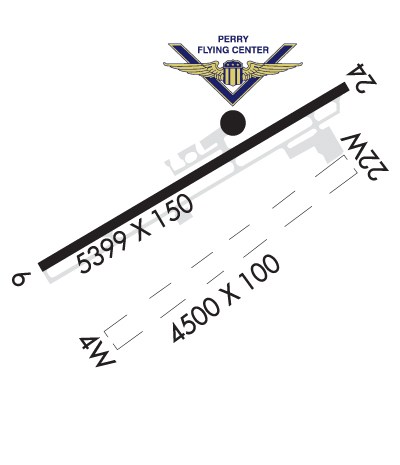
| Lat: N 2942.6 Long: W 09120.3 Elev: 9 Var: -01 Longest Runway: 5399 | ||
| Clr Del: 124.3 AWOS: 134.57 CTAF: 122.8 | ||
| ||||||||||||||||||||||||||||||||||||||||||||
| ||||||||||||||||||||||||||||||||||||||||||||
| ||||||||||||||||||||||||||||||||||||||||||||
| Rwy | Rwy | |||||||
| 4500x100 | 4500' | 4500x100 | 4500' | |||||
| 5399x150 | 5005' | 5399x150 | 5399' | 108.30 - 238° | ||||
| Runway ID | Single Wheel | Double Wheel | Double Tandem Wheel | Dual Double Wheel |
| 04W/22W | N/A | N/A | N/A | N/A |
| 06/24 | 32,000 | N/A | N/A | N/A |
| These numbers are Advisory and are not limits. The Airport Manager should have more accurate Weight Limits | ||||
 Airport Diagram might not be current. | |
| Facility Name: | HARRY P WILLIAMS MEML |
| City Name: | PATTERSON |
| County: | ST MARY |
| State abbrev: | LA |
| State Name: | LOUISIANA |
| Ownership: | PUBLICLY OWNED |
| Use: | OPEN TO THE PUBLIC |
| Owner's Name: | STATE OF LOUISIANA |
| Address: | DOTD AVIATION SECTION, PO BOX 94245 |
| BATON ROUGE, LA 70804 | |
| Owner's Phone: | 225-379-3950 |
| Manager's Name: | PAUL J. GOVERNAK |
| Address: | 500 MAIN ST, 5TH FLOOR COURTHOUSE |
| FRANKLIN, LA 70538 | |
| Phone: | 337-828-4100 |
| FAA Region: | SOUTHWEST |
| FAA Field Office: | LNM |

| Date | Sunrise | Sunset |
|---|---|---|
| 06/12/26 Friday | 6:04 | 20:06 |
| 06/13/26 Saturday | 6:04 | 20:06 |
| 06/14/26 Sunday | 6:04 | 20:07 |
| 06/15/26 Monday | 6:04 | 20:07 |
| 06/16/26 Tuesday | 6:05 | 20:07 |
| 06/17/26 Wednesday | 6:05 | 20:08 |
| 06/18/26 Thursday | 6:05 | 20:08 |
| 06/19/26 Friday | 6:05 | 20:08 |
| 06/20/26 Saturday | 6:05 | 20:09 |
| 06/21/26 Sunday | 6:05 | 20:09 |
| 06/22/26 Monday | 6:06 | 20:09 |
| 06/23/26 Tuesday | 6:06 | 20:09 |
| 06/24/26 Wednesday | 6:06 | 20:09 |
| 06/25/26 Thursday | 6:06 | 20:09 |
| Airport Attendance Schedule | CONTINUOUS |
| Airport Status | OPERATIONAL (This Status can change at any time - please check NOTAMS) |
| Airport Lighting Schedule | ACTVT MALSR RWY 24; MIRL RWY 06/24 PRESET MED INTST, TO INCR INTST - CTAF. |
| Airport Storage Available | Tie Downs, Hanger |
| Extra Services Available | Crop Dusting, Avionics, Charter, Flight Instruction |
| Wind Indicator | YES - (lighted) |
| Control Tower | NO |
| CTAF Frequency | 122.800 |
| Unicom Frequency | 122.800 |
| Rotating Beacon Color | WG |
| Segmented Circle | NO |
| Landing Fee | NO |
| Airport Inspected | STATE - performed by STATE AERONAUTICAL PERSONNEL |
| Inspection Date | 07/19/2023 |
| Type of Fuel Available | Grade 100LL, JET A (freeze point -40C) |
| Airframe Repair Service | MAJOR |
| Power Plant Repair Service | MAJOR |
| Latitude | N2942.6 |
| Longitude | W09120.3 (ESTIMATED) |
| Arpt Elevation | 8ft (SURVEYED) |
| Magnetic Variation | 01E |
| 2 miles NW | of PATTERSON |
| Traffic Pattern Altitude | |
| Sectional Chart | HOUSTON |
| Operations (Reported) | Yearly | Avg. Daily |
|---|---|---|
| General Aviation Transient | 0 | 0 |
| General Aviation Local | 0 | 0 |
| Air Taxi | 0 | 0 |
| Commerical | 0 | 0 |
| Commuter | 0 | 0 |
| Military | 0 | 0 |
| Aircraft based on Field | |
|---|---|
| General Aviation Singles | 0 |
| General Aviation Multi | 0 |
| Jet Aircraft | 0 |
| General Aviation Helicopters | 0 |
| Military Aircraft | 0 |
| Gliders | 0 |
| Ultralights | 0 |
| FSS on field | NO |
| FSS tie-in | DE RIDDER |
| FSS Phone | 1-800-WX-BRIEF |
| Who issues Notams | PTN |
| Notam D service at airport | YES |
| ARTCC Name | HOUSTON |
| Airport Certification | |
| Aircraft Rescue & Firefighting Index | None |
| Airport of Entry | No |
| Custom Landing Rights | YES |
| Joint Civil/Military | No |
| Military Landing rights | YES |
| NATIONAL PLAN OF INTEGRATED AIRPORT SYSTEMS (NPIAS) |
| GRANT AGREEMENTS UNDER FAAP/ADAP/AIP |
| ASSURANCES PURSUANT TO TITLE VI, CIVIL RIGHTS ACT OF 1964 |
| 4500 FT BY 100 FT WATERWAY HDG 04/22 LCTD 1100 FT SOUTH OF CONC RWY. DUAL LAND/SEA OPERATION. |
| FOR CD CTC NEW ORLEANS APCH AT 504-471-4350 OR 124.3. |
| PILOTS CONDUCTING EFVS OPS; BE AWARE LED ALS IN USE RWY 24. |
| CTC ARPT MGR FOR DSNGD RAMP SPACE FOR PUB USE AT ARPT |
Airport Communications & Frequencies:
| ||||||||||||||||
| Runway: 04W | Runway: 22W | ||
| Mag heading: | 54° | Mag heading: | 234° |
| Rwy Slope: | .00% | Rwy Slope: | .00% |
| Approach: | Approach: | ||
| Pattern: | Right Traffic | Pattern: | Left Traffic |
| Markings: | Markings: | ||
| Marking Condition: | Marking Condition: | ||
| Arresting Dev: | Arresting Dev: | ||
| Lat & Long: | N2942.3 W09120.6 | Lat. & Long.: | N2942.7 W09119.9 |
| Elev: | 1.0 ft. MSL | Elev: | 1.0 ft. MSL |
| TCH: | TCH: | ||
| Visual Glide Path: | Visual Glide Path: | ||
| Displaced Threshold: | No | Displaced Threshold: | No |
| Touchdown Zone: | YES | Touchdown Zone: | YES |
| Touchdown Elev.: | 1.0 feet | Touchdown Elev.: | 1.0 feet |
| Visual Glide Slope: | Visual Glide Slope: | ||
| RVR Equipment: | RVR Equipment: | ||
| RVV Equipment: | NO | RVV Equipment: | NO |
| Approach Lights: | Approach Lights: | ||
| REIL: | NO | REIL: | NO |
| Centerline Lights: | NO | Centerline Lights: | NO |
| Touchdown lights: | NO | Touchdown lights: | NO |
| Runway Category: | Runway with a Visual Approach | Runway Category: | Runway with a Visual Approach |
| Declared Distances: | Declared Distances: | ||
| Obstructions: | ROAD | Obstructions: | |
| Marked: | NOT Marked/Lighted | Marked: | |
| Clearance slope: | 30:1 | Clearance slope: | 20:1 |
| Obstruction height: | 20 feet AGL | Obstruction height: | |
| Dist. from runway: | 600 feet | Dist. from runway: | |
| Centerline offset: | Centerline offset: | ||
| Comments: | Comments: |
| Runway: 06 | Runway: 24 | ||
| Mag heading: | 58° | Mag heading: | 238° |
| Rwy Slope: | .03% Up | Rwy Slope: | -.03% Down |
| Approach: | Approach: | ILS/DME | |
| Pattern: | Left Traffic | Pattern: | Right Traffic |
| Markings: | NONPRECISION INSTRUMENT | Markings: | PRECISION INSTRUMENT |
| Marking Condition: | FAIR | Marking Condition: | FAIR |
| Arresting Dev: | Arresting Dev: | ||
| Lat & Long: | N2942.4 W09120.8 | Lat. & Long.: | N2942.9 W09119.9 |
| Elev: | 6.7 ft. MSL | Elev: | 8.4 ft. MSL |
| TCH: | 50 ft. AGL | TCH: | 50 ft. AGL |
| Visual Glide Path: | 3.00 degrees | Visual Glide Path: | 3.00 degrees |
| Displaced Threshold: | 394 feet | Displaced Threshold: | No |
| Touchdown Zone: | YES | Touchdown Zone: | YES |
| Touchdown Elev.: | 8.5 feet | Touchdown Elev.: | 8.5 feet |
| Visual Glide Slope: | 2-Light PAPI on LEFT side of Runway | Visual Glide Slope: | 2-Light PAPI on LEFT side of Runway |
| RVR Equipment: | RVR Equipment: | ||
| RVV Equipment: | NO | RVV Equipment: | NO |
| Approach Lights: | Approach Lights: | MALSR - 1,400 foot medium intensity approach lighting system with runway alignment indicator lights | |
| REIL: | YES | REIL: | NO |
| Centerline Lights: | NO | Centerline Lights: | NO |
| Touchdown lights: | NO | Touchdown lights: | NO |
| Runway Category: | Runway with a Non-precision Approach having visibility minimums greater than 3/4 mile | Runway Category: | Precision Instrument Runway |
| Declared Distances: | Declared Distances: | ||
| Obstructions: | TREES | Obstructions: | |
| Marked: | NOT Marked/Lighted | Marked: | |
| Clearance slope: | 22:1; APCH RATIO 23:1 TO DTHR. | Clearance slope: | 50:1 |
| Obstruction height: | 58 feet AGL | Obstruction height: | |
| Dist. from runway: | 1491 feet | Dist. from runway: | |
| Centerline offset: | 262 left of centerline | Centerline offset: | |
| Comments: | Comments: |
Thanks for using FltPlan.com
all rights reserved © 1999-2026 by Flight Plan LLC