
| OAKLAND COUNTY INTL PONTIAC MI |
| |
| Lat: N 4239.9 Long: W 08325.2 Elev: 981 Var: +07 Longest Runway: 6521 | ||
| Clr Del: 118.25 Dept. ATIS: 125.02 Arr. ATIS: 125.02 Ground: 121.65/121.9 Tower: 120.5/123.7 | ||
| |||||||||||||||||||||||||||||||||||||||||||||||||||||||||||||||||||||
| |||||||||||||||||||||||||||||||||||||||||||||||||||||||||||||||||||||
| |||||||||||||||||||||||||||||||||||||||||||||||||||||||||||||||||||||
| |||||||||||||||||||||||||||||||||||||||||||||||||||||||||||||||||||||
| |||||||||||||||||||||||||||||||||||||||||||||||||||||||||||||||||||||
| |||||||||||||||||||||||||||||||||||||||||||||||||||||||||||||||||||||
| |||||||||||||||||||||||||||||||||||||||||||||||||||||||||||||||||||||
| |||||||||||||||||||||||||||||||||||||||||||||||||||||||||||||||||||||
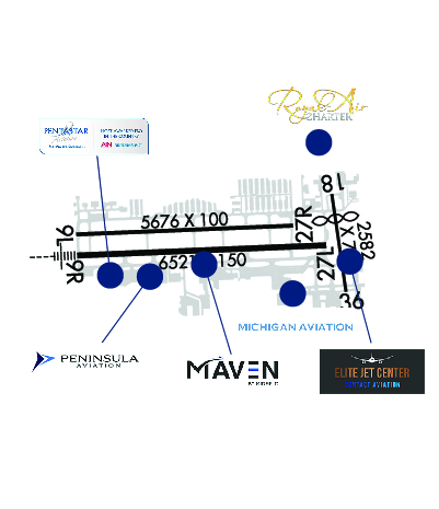
| FBOs at nearby airports who want your business: | ||||||||||
| ||||||||||
| Rwy | Rwy | |||||||
| 5676x100 | 5676' | 5676x100 | 5676' | |||||
| 6521x150 | 6521' | 111.10 - 094° | 6521x150 | 6521' | ||||
| 2582x75 | 1932' | 2582x75 | 2582' | |||||
| Runway ID | Single Wheel | Double Wheel | Double Tandem Wheel | Dual Double Wheel |
| 09L/27R | 57,500 | 81,000 | 156,000 | N/A |
| 09R/27L | 120,000 | 219,000 | 404,000 | N/A |
| 18/36 | N/A | N/A | N/A | N/A |
| These numbers are Advisory and are not limits. The Airport Manager should have more accurate Weight Limits | ||||
 Airport Diagram might not be current. | |
| Facility Name: | OAKLAND COUNTY INTL |
| City Name: | PONTIAC |
| County: | OAKLAND |
| State abbrev: | MI |
| State Name: | MICHIGAN |
| Ownership: | PUBLICLY OWNED |
| Use: | OPEN TO THE PUBLIC |
| Owner's Name: | COUNTY OF OAKLAND |
| Address: | 1200 N TELEGRAPH RD |
| PONTIAC, MI 48341 | |
| Owner's Phone: | 248-666-3900 |
| Manager's Name: | CHERYL BUSH |
| Address: | 6500 PATTERSON PKWY |
| WATERFORD, MI 48327-1683 | |
| Phone: | 248-666-3900 |
| FAA Region: | GREAT LAKES |
| FAA Field Office: | DET |
| Date | Sunrise | Sunset |
|---|---|---|
| 09/24/21 Friday | 7:23 | 19:28 |
| 09/25/21 Saturday | 7:24 | 19:26 |
| 09/26/21 Sunday | 7:25 | 19:24 |
| 09/27/21 Monday | 7:26 | 19:23 |
| 09/28/21 Tuesday | 7:27 | 19:21 |
| 09/29/21 Wednesday | 7:28 | 19:19 |
| 09/30/21 Thursday | 7:29 | 19:17 |
| 10/01/21 Friday | 7:31 | 19:15 |
| 10/02/21 Saturday | 7:32 | 19:14 |
| 10/03/21 Sunday | 7:33 | 19:12 |
| 10/04/21 Monday | 7:34 | 19:10 |
| 10/05/21 Tuesday | 7:35 | 19:08 |
| 10/06/21 Wednesday | 7:36 | 19:07 |
| 10/07/21 Thursday | 7:37 | 19:05 |
| Airport Attendance Schedule | CONTINUOUS |
| Airport Status | OPERATIONAL (This Status can change at any time - please check NOTAMS) |
| Airport Lighting Schedule | WHEN ATCT CLSD ACTVT MALSR RWY 09R; REIL RWY 27L; PAPI RWY 09R & 27L; HIRL RWY 09R/27L - CTAF. |
| Airport Storage Available | Tie Downs, Hanger |
| Extra Services Available | Air Freight, Avionics, Cargo Handling, Charter, Flight Instruction, Aircraft Rental, Aircraft Sales |
| Wind Indicator | YES - (lighted) |
| Control Tower | YES |
| CTAF Frequency | 120.500 |
| Unicom Frequency | 122.950 |
| Rotating Beacon Color | CLEAR-GREEN (Light Land Airport) |
| Segmented Circle | NO |
| Landing Fee | YES; LDG FEE FOR ACFT OVR 12500 LBS. |
| Airport Inspected | FEDERAL - performed by FAA AIRPORTS FIELD PERSONNEL |
| Inspection Date | 02/06/2020 |
| Type of Fuel Available | Grade 100LL, JET A (freeze point -40C) |
| Airframe Repair Service | MAJOR |
| Power Plant Repair Service | MAJOR |
| Latitude | N4239.9 |
| Longitude | W08325.2 (ESTIMATED) |
| Arpt Elevation | 980ft (SURVEYED) |
| Magnetic Variation | 07W |
| 5 miles W | of PONTIAC |
| Traffic Pattern Altitude | |
| Sectional Chart | DETROIT |
| Operations (Reported) | Yearly | Avg. Daily |
|---|---|---|
| General Aviation Transient | 47435 | 130 |
| General Aviation Local | 66271 | 182 |
| Air Taxi | 9075 | 25 |
| Commerical | 247 | 1 |
| Commuter | 0 | 0 |
| Military | 304 | 1 |
| Aircraft based on Field | |
|---|---|
| General Aviation Singles | 295 |
| General Aviation Multi | 97 |
| Jet Aircraft | 188 |
| General Aviation Helicopters | 14 |
| Military Aircraft | 0 |
| Gliders | 0 |
| Ultralights | 0 |
| FSS on field | NO |
| FSS tie-in | LANSING |
| FSS Phone | 1-800-WX-BRIEF |
| Who issues Notams | PTK |
| Notam D service at airport | YES |
| ARTCC Name | CLEVELAND |
| Airport Certification | CLSD TO SKEDD ACR OPS GTR THAN 9 PAX SEATS. 48 HR PPR FOR UNSKED ACR OPS GTR THAN 9 PAX SEATS - CALL AMGR. |
| Aircraft Rescue & Firefighting Index | AIRPORT HAS A CERTIFICATE UNDER CFR PART 139 |
| Airport of Entry | No |
| Custom Landing Rights | YES; US CUSTOMS USER FEE ARPT. |
| Joint Civil/Military | No |
| Military Landing rights | YES |
| NATIONAL PLAN OF INTEGRATED AIRPORT SYSTEMS (NPIAS) |
| GRANT AGREEMENTS UNDER FAAP/ADAP/AIP |
| ASSURANCES PURSUANT TO TITLE VI, CIVIL RIGHTS ACT OF 1964 |
| ATCT UNA TO SEE MORE THAN 200 FT SOUTH OF RWY 36 THR AND TWY A2 BTN TWYS A & B. |
| BIRDS & DEER ON & INVOF ARPT. |
| SEAPLANE LDGS & TAKEOFFS ON LAKE ANGELUS 4.5 MILES ENE IS PROHIBITED BY LOCAL ORDINANCES. |
| U.S. CUSTOMS USER FEE ARPT. CONTACT U.S. CUSTOMS 0700-2000 MON-FRI ON 248-666-7717; OTHER TIMES MIN 3 HRS ADVANCE NOTIFICATION ON 734-942-9000. |
| RY 18/36 AVBL TO ACFT 12,500 LBS AND UNDER DAY VFR USE ONLY. |
| FOR CD WHEN ATCT IS CLSD CTC DETROIT APCH AT 800-499-8181. |
| RWY 09L/ 27RCLSD TO UNSKED ACR OPS GTR THAN 30 PAX SEATS. |
| RWY 18/3 6 CLSD TO UNSKED ACR OPS GTR THAN 30 PAX SEATS. |
Airport Communications & Frequencies:
| |||||||||||||||||||||||||||||
| Runway: 09L | Runway: 27R | ||
| Mag heading: | 95° | Mag heading: | 275° |
| Rwy Slope: | -.02% Down | Rwy Slope: | .02% Up |
| Approach: | Approach: | ||
| Pattern: | Left Traffic | Pattern: | Left Traffic |
| Markings: | BASIC | Markings: | BASIC |
| Marking Condition: | FAIR | Marking Condition: | FAIR |
| Arresting Dev: | Arresting Dev: | ||
| Lat & Long: | N4240.0 W08326.1 | Lat. & Long.: | N4240.0 W08324.8 |
| Elev: | 973.8 ft. MSL | Elev: | 972.6 ft. MSL |
| TCH: | 40 ft. AGL | TCH: | 51 ft. AGL |
| Visual Glide Path: | 3.00 degrees | Visual Glide Path: | 3.00 degrees |
| Displaced Threshold: | No | Displaced Threshold: | No |
| Touchdown Zone: | YES | Touchdown Zone: | YES |
| Touchdown Elev.: | 975.8 feet | Touchdown Elev.: | 974.0 feet |
| Visual Glide Slope: | 4-Light PAPI on LEFT side of Runway | Visual Glide Slope: | 4-Light PAPI on LEFT side of Runway |
| RVR Equipment: | RVR Equipment: | ||
| RVV Equipment: | NO | RVV Equipment: | NO |
| Approach Lights: | Approach Lights: | ||
| REIL: | YES | REIL: | YES |
| Centerline Lights: | NO | Centerline Lights: | NO |
| Touchdown lights: | NO | Touchdown lights: | NO |
| Runway Category: | Runway with a Visual Approach | Runway Category: | Runway with a Visual Approach |
| Declared Distances: | TORA:5675' TODA:5675' ASDA:5675' LDA:5675' | Declared Distances: | TORA:5675' TODA:5675' ASDA:5675' LDA:5675' |
| Runway: 09R | Runway: 27L | ||
| Mag heading: | 95° | Mag heading: | 275° |
| Rwy Slope: | -.14% Down | Rwy Slope: | .14% Up |
| Approach: | ILS | Approach: | |
| Pattern: | Left Traffic | Pattern: | Left Traffic |
| Markings: | PRECISION INSTRUMENT | Markings: | PRECISION INSTRUMENT |
| Marking Condition: | FAIR | Marking Condition: | FAIR |
| Arresting Dev: | Arresting Dev: | ||
| Lat & Long: | N4239.9 W08326.1 | Lat. & Long.: | N4239.9 W08324.6 |
| Elev: | 980.4 ft. MSL | Elev: | 971.5 ft. MSL |
| TCH: | 45 ft. AGL | TCH: | 42 ft. AGL |
| Visual Glide Path: | 3.00 degrees | Visual Glide Path: | 3.00 degrees |
| Displaced Threshold: | No | Displaced Threshold: | No |
| Touchdown Zone: | YES | Touchdown Zone: | YES |
| Touchdown Elev.: | 980.6 feet | Touchdown Elev.: | 974.3 feet |
| Visual Glide Slope: | 4-Light PAPI on LEFT side of Runway | Visual Glide Slope: | 4-Light PAPI on LEFT side of Runway; PAPI UNUSBL BYD 8 DEGS RIGHT OF CNTRLN. |
| RVR Equipment: | TOUCHDOWN | RVR Equipment: | ROLLOUT |
| RVV Equipment: | NO | RVV Equipment: | NO |
| Approach Lights: | MALSR - 1,400 foot medium intensity approach lighting system with runway alignment indicator lights | Approach Lights: | |
| REIL: | NO | REIL: | YES |
| Centerline Lights: | NO | Centerline Lights: | NO |
| Touchdown lights: | NO | Touchdown lights: | NO |
| Runway Category: | Precision Instrument Runway | Runway Category: | D |
| Declared Distances: | TORA:6520' TODA:6520' ASDA:6520' LDA:6520' | Declared Distances: | TORA:6520' TODA:6520' ASDA:6520' LDA:6520' |
| Runway: 18 | Runway: 36 | ||
| Mag heading: | 179° | Mag heading: | 359° |
| Rwy Slope: | -.15% Down | Rwy Slope: | .15% Up |
| Approach: | Approach: | ||
| Pattern: | Left Traffic | Pattern: | Left Traffic |
| Markings: | Markings: | ||
| Marking Condition: | Marking Condition: | ||
| Arresting Dev: | Arresting Dev: | ||
| Lat & Long: | N4240.1 W08324.6 | Lat. & Long.: | N4239.7 W08324.5 |
| Elev: | 973.4 ft. MSL | Elev: | 969.4 ft. MSL |
| TCH: | TCH: | 30 ft. AGL | |
| Visual Glide Path: | Visual Glide Path: | 3.00 degrees | |
| Displaced Threshold: | 650 feet | Displaced Threshold: | No |
| Touchdown Zone: | YES | Touchdown Zone: | YES |
| Touchdown Elev.: | 973.4 feet | Touchdown Elev.: | 973.4 feet |
| Visual Glide Slope: | Visual Glide Slope: | 2-Light PAPI on LEFT side of Runway | |
| RVR Equipment: | RVR Equipment: | ||
| RVV Equipment: | NO | RVV Equipment: | NO |
| Approach Lights: | Approach Lights: | ||
| REIL: | NO | REIL: | NO |
| Centerline Lights: | NO | Centerline Lights: | NO |
| Touchdown lights: | NO | Touchdown lights: | NO |
| Runway Category: | Runway with a Visual Approach | Runway Category: | Runway with a Visual Approach |
| Declared Distances: | Declared Distances: |
Thanks for using FltPlan.com
all rights reserved © 1999-2021 by Flight Plan LLC