
| PALM SPRINGS INTL PALM SPRINGS CA |
| |
| Lat: N 3349.8 Long: W 11630.4 Elev: 476 Var: -13 Longest Runway: 10000 | ||
| Clr Del: 128.35 Dept. ATIS: 124.65 Arr. ATIS: 124.65 Ground: 121.9 Tower: 119.7 | ||
| |||||||||||||||||||||||||||||||||||||||||||||||||||||||||||||||||||||
| |||||||||||||||||||||||||||||||||||||||||||||||||||||||||||||||||||||
| |||||||||||||||||||||||||||||||||||||||||||||||||||||||||||||||||||||
| |||||||||||||||||||||||||||||||||||||||||||||||||||||||||||||||||||||
| |||||||||||||||||||||||||||||||||||||||||||||||||||||||||||||||||||||
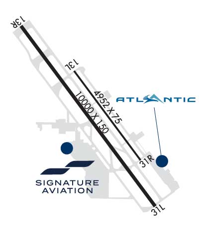
| FBOs at nearby airports who want your business: | |||||||||||||||||
| |||||||||||||||||
| Rwy | Rwy | |||||||
| 4952x75 | 4952' | 4952x75 | 4952' | |||||
| 10000x150 | 7000' | 10000x150 | 8500' | |||||
| Runway ID | Single Wheel | Double Wheel | Double Tandem Wheel | Dual Double Wheel |
| 13L/31R | N/A | N/A | N/A | N/A |
| 13R/31L | N/A | N/A | N/A | N/A |
| These numbers are Advisory and are not limits. The Airport Manager should have more accurate Weight Limits | ||||
 Airport Diagram might not be current. | |
| Facility Name: | PALM SPRINGS INTL |
| City Name: | PALM SPRINGS |
| County: | RIVERSIDE |
| State abbrev: | CA |
| State Name: | CALIFORNIA |
| Ownership: | PUBLICLY OWNED |
| Use: | OPEN TO THE PUBLIC |
| Owner's Name: | CITY OF PALM SPRINGS |
| Address: | 3400 E. TAHQUITZ CANYON WAY |
| PALM SPRINGS, CA 92262 | |
| Owner's Phone: | 760-318-3800 |
| Manager's Name: | ULISES AGUIRRE; ULISES AGUIRRE IS INTERIM MANAGER (760) 318-3807 |
| Address: | 3400 E. TAHQUITZ-CANYON WAY, SUITE OFC |
| PALM SPRINGS, CA 92262 | |
| Phone: | 760-318-3800 |
| FAA Region: | WESTERN-PACIFIC |
| FAA Field Office: | LAX |

| Date | Sunrise | Sunset |
|---|---|---|
| 09/24/21 Friday | 6:35 | 18:40 |
| 09/25/21 Saturday | 6:36 | 18:39 |
| 09/26/21 Sunday | 6:37 | 18:37 |
| 09/27/21 Monday | 6:37 | 18:36 |
| 09/28/21 Tuesday | 6:38 | 18:35 |
| 09/29/21 Wednesday | 6:39 | 18:33 |
| 09/30/21 Thursday | 6:40 | 18:32 |
| 10/01/21 Friday | 6:40 | 18:31 |
| 10/02/21 Saturday | 6:41 | 18:29 |
| 10/03/21 Sunday | 6:42 | 18:28 |
| 10/04/21 Monday | 6:42 | 18:26 |
| 10/05/21 Tuesday | 6:43 | 18:25 |
| 10/06/21 Wednesday | 6:44 | 18:24 |
| 10/07/21 Thursday | 6:45 | 18:22 |
| Airport Attendance Schedule | CONTINUOUS |
| Airport Status | OPERATIONAL (This Status can change at any time - please check NOTAMS) |
| Airport Lighting Schedule | WHEN TWR CLSD ACTVT REIL RWY 13R & 31L; PAPI RWY 13R & 31L; HIRL RWY 13R/31L - CTAF. REIL RWY 13L & 31R; PAPI RWY 13L & 31R; MIRL RWY 13L/31R; TWY E NOT LGTD WHEN TWR CLSD. |
| Airport Storage Available | Tie Downs, Hanger |
| Extra Services Available | Air Freight, Charter, Flight Instruction, Aircraft Rental, Aircraft Sales |
| Wind Indicator | YES - (lighted) |
| Control Tower | YES |
| CTAF Frequency | 119.700 |
| Unicom Frequency | 122.950 |
| Rotating Beacon Color | CLEAR-GREEN (Light Land Airport) |
| Segmented Circle | YES |
| Landing Fee | NO |
| Airport Inspected | FEDERAL - performed by FAA AIRPORTS FIELD PERSONNEL |
| Inspection Date | 04/18/2019 |
| Type of Fuel Available | Grade 100LL, JET A (freeze point -40C) |
| Airframe Repair Service | MAJOR |
| Power Plant Repair Service | MAJOR |
| Latitude | N3349.8 |
| Longitude | W11630.4 (ESTIMATED) |
| Arpt Elevation | 476ft (SURVEYED) |
| Magnetic Variation | 13E |
| 2 miles E | of PALM SPRINGS |
| Traffic Pattern Altitude | TPA: 1,500 FT. AGL LARGE ACFT, 1,000 FT AGL SMALL ACFT. |
| Sectional Chart | LOS ANGELES |
| Operations (Reported) | Yearly | Avg. Daily |
|---|---|---|
| General Aviation Transient | 19766 | 54 |
| General Aviation Local | 4022 | 11 |
| Air Taxi | 10872 | 30 |
| Commerical | 21226 | 58 |
| Commuter | 0 | 0 |
| Military | 1626 | 4 |
| Aircraft based on Field | |
|---|---|
| General Aviation Singles | 62 |
| General Aviation Multi | 8 |
| Jet Aircraft | 10 |
| General Aviation Helicopters | 1 |
| Military Aircraft | 0 |
| Gliders | 0 |
| Ultralights | 0 |
| FSS on field | NO |
| FSS tie-in | RIVERSIDE |
| FSS Phone | 1-800-WX-BRIEF |
| Who issues Notams | PSP |
| Notam D service at airport | YES |
| ARTCC Name | LOS ANGELES |
| Airport Certification | AIRPORT RECEIVING SCHEDULED AIR CARRIER SERVICE FROM CARRIERS CERTIFICATED BY THE CIVIL AERONAUTICS BOARD |
| Aircraft Rescue & Firefighting Index | AIRPORT HAS A CERTIFICATE UNDER CFR PART 139 |
| Airport of Entry | No |
| Custom Landing Rights | YES; CUSTOMS AVBL 24 HRS; 4 HRS PRIOR NOTIFICATION REQUIRED CALL (760) 318-3880 FAX 3883. |
| Joint Civil/Military | No |
| Military Landing rights | YES |
| NATIONAL PLAN OF INTEGRATED AIRPORT SYSTEMS (NPIAS) |
| GRANT AGREEMENTS UNDER FAAP/ADAP/AIP |
| SURPLUS PROPERTY AGREEMENT UNDER PUBLIC LAW 289 |
| ASSURANCES PURSUANT TO TITLE VI, CIVIL RIGHTS ACT OF 1964 |
| AGREEMENT UNDER DLAND OR DCLA HAS EXPIRED. |
| ACCESS TO/FROM FBO RAMP VIA TWY G LMTD TO ACFT WITH WINGSPAN OF LESS THAN 40 FT. |
| LENGTHY ENG IDLING AND RUN-UPS ON RAMP AREA PROHIBITED. CTC ARPT OPS 760-318-3820 FOR NOISE MEDIATION PROCEDURES. |
| RWY 13L/31R LGTD DIST RMNG MKRS ON E SIDE ONLY. RWY 13R/31L LGTD DIST RMNG MKRS ON W SIDE ONLY. |
| DO NOT MISTAKE CENTER TWY (TWY C) AS RWY 13R/31L. |
| FOR CD WHEN ATCT CLSD CTC SOCAL APCH AT 800-448-3724. |
| NOISE SENSITIVE AREA ALL QUADRANTS; EXERCISE QUIET FLT PROCEDURES. FOR FURTHER INFO CTC DUTY SUPERVISOR (760) 318-3820. |
| RY 13R DESIGNATED CALM WIND RY. |
| NO FORMATION LDGS OR TAKEOFFS OR OVERHEAD MANEUVERS |
Airport Communications & Frequencies:
| ||||||||||||||||||||||||||||||||||||
| Runway: 13L | Runway: 31R | ||
| Mag heading: | 130° | Mag heading: | 310° |
| Rwy Slope: | -.85% Down | Rwy Slope: | .85% Up |
| Approach: | Approach: | ||
| Pattern: | Left Traffic | Pattern: | Right Traffic |
| Markings: | BASIC | Markings: | BASIC |
| Marking Condition: | GOOD | Marking Condition: | GOOD |
| Arresting Dev: | Arresting Dev: | ||
| Lat & Long: | N3350.1 W11630.6 | Lat. & Long.: | N3349.5 W11630.0 |
| Elev: | 448.9 ft. MSL | Elev: | 406.9 ft. MSL |
| TCH: | 38 ft. AGL | TCH: | 39 ft. AGL |
| Visual Glide Path: | 3.20 degrees | Visual Glide Path: | 3.20 degrees |
| Displaced Threshold: | No | Displaced Threshold: | No |
| Touchdown Zone: | YES | Touchdown Zone: | YES |
| Touchdown Elev.: | 448.9 feet | Touchdown Elev.: | 432.0 feet |
| Visual Glide Slope: | 4-Light PAPI on LEFT side of Runway | Visual Glide Slope: | 4-Light PAPI on LEFT side of Runway; UNUSBL BYD 8 DEGS RIGHT OF CNTRLN AND BYD 4 NM FROM THR DUE TO MOUNTAINOUS TRRN. |
| RVR Equipment: | RVR Equipment: | ||
| RVV Equipment: | NO | RVV Equipment: | NO |
| Approach Lights: | Approach Lights: | ||
| REIL: | YES | REIL: | YES |
| Centerline Lights: | NO | Centerline Lights: | NO |
| Touchdown lights: | NO | Touchdown lights: | NO |
| Runway Category: | Runway with a Visual Approach | Runway Category: | Runway with a Visual Approach |
| Declared Distances: | TORA:4952' TODA:4952' ASDA:4952' LDA:4952' | Declared Distances: | TORA:4952' TODA:4952' ASDA:4952' LDA:4952' |
| Runway: 13R | Runway: 31L | ||
| Mag heading: | 130° | Mag heading: | 310° |
| Rwy Slope: | -.78% Down | Rwy Slope: | .78% Up |
| Approach: | Approach: | ||
| Pattern: | Left Traffic | Pattern: | Right Traffic |
| Markings: | PRECISION INSTRUMENT | Markings: | PRECISION INSTRUMENT |
| Marking Condition: | GOOD | Marking Condition: | GOOD |
| Arresting Dev: | Arresting Dev: | ||
| Lat & Long: | N3350.4 W11631.0 | Lat. & Long.: | N3349.1 W11629.9 |
| Elev: | 476.4 ft. MSL | Elev: | 398.2 ft. MSL |
| TCH: | 47 ft. AGL | TCH: | 55 ft. AGL |
| Visual Glide Path: | 3.00 degrees | Visual Glide Path: | 3.00 degrees |
| Displaced Threshold: | 3000 feet | Displaced Threshold: | 1500 feet |
| Touchdown Zone: | YES | Touchdown Zone: | YES |
| Touchdown Elev.: | 451.1 feet | Touchdown Elev.: | 429.3 feet |
| Visual Glide Slope: | 4-Light PAPI on LEFT side of Runway; UNUSBL BYD 9 DEGS LEFT OF CNTRLN | Visual Glide Slope: | 4-Light PAPI on RIGHT side of Runway; RWY 31L PAPI UNUSBL BYD 4 NM FROM THLD DUE TO MOUNTAINOUS TER |
| RVR Equipment: | RVR Equipment: | ||
| RVV Equipment: | NO | RVV Equipment: | NO |
| Approach Lights: | Approach Lights: | ||
| REIL: | YES | REIL: | YES |
| Centerline Lights: | NO | Centerline Lights: | NO |
| Touchdown lights: | NO | Touchdown lights: | NO |
| Runway Category: | Runway with a Non-precision Approach having visibility minimums greater than 3/4 mile | Runway Category: | Runway with a Non-precision Approach having visibility minimums greater than 3/4 mile |
| Declared Distances: | TORA:10000' TODA:10000' ASDA:9857' LDA:6857' | Declared Distances: | TORA:10000' TODA:10000' ASDA:10000' LDA:8500' |
| Comments: | RISING TERRAIN N OF APCH END OF RY 13R. | Comments: |
Thanks for using FltPlan.com
all rights reserved © 1999-2021 by Flight Plan LLC


