
| NEW RIVER VALLEY DUBLIN VA |
| |
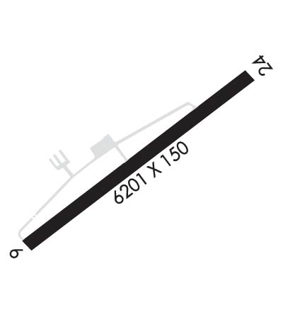
| Lat: N 3708.2 Long: W 08040.7 Elev: 2105 Var: +06 Longest Runway: 6201 | ||
| Clr Del: 121.7 AWOS: 127.37 CTAF: 122.7 | ||
| ||||||||||||||||||||||||||||||||||||||||||||
| ||||||||||||||||||||||||||||||||||||||||||||
| ||||||||||||||||||||||||||||||||||||||||||||
| Rwy | Rwy | |||||||
| 6201x150 | 6201' | 110.90 - 058° | 6201x150 | 6201' | ||||
| Runway ID | Single Wheel | Double Wheel | Double Tandem Wheel | Dual Double Wheel |
| 06/24 | N/A | 60,000 | N/A | N/A |
| These numbers are Advisory and are not limits. The Airport Manager should have more accurate Weight Limits | ||||
 Airport Diagram might not be current. | |
| Facility Name: | NEW RIVER VALLEY |
| City Name: | DUBLIN |
| County: | PULASKI |
| State abbrev: | VA |
| State Name: | VIRGINIA |
| Ownership: | PUBLICLY OWNED |
| Use: | OPEN TO THE PUBLIC |
| Owner's Name: | NEW RIVER VALLEY ARPT CMSN |
| Address: | 5391 C. V. JACKSON ROAD |
| DUBLIN, VA 24084 | |
| Owner's Phone: | 540-674-4141 |
| Manager's Name: | AARON BRUMMITT |
| Address: | 5391 C. V. JACKSON ROAD |
| DUBLIN, VA 24084 | |
| Phone: | 540-674-4141 |
| FAA Region: | EASTERN |
| FAA Field Office: | DCA |
| Date | Sunrise | Sunset |
|---|---|---|
| 06/08/26 Monday | 6:02 | 20:41 |
| 06/09/26 Tuesday | 6:02 | 20:42 |
| 06/10/26 Wednesday | 6:02 | 20:42 |
| 06/11/26 Thursday | 6:02 | 20:43 |
| 06/12/26 Friday | 6:02 | 20:43 |
| 06/13/26 Saturday | 6:02 | 20:43 |
| 06/14/26 Sunday | 6:02 | 20:44 |
| 06/15/26 Monday | 6:02 | 20:44 |
| 06/16/26 Tuesday | 6:02 | 20:45 |
| 06/17/26 Wednesday | 6:02 | 20:45 |
| 06/18/26 Thursday | 6:02 | 20:45 |
| 06/19/26 Friday | 6:02 | 20:46 |
| 06/20/26 Saturday | 6:03 | 20:46 |
| 06/21/26 Sunday | 6:03 | 20:46 |
| Airport Attendance Schedule | MON-FRI 0800-1900, SAT-SUN 0900-1700; UNATNDD NEW YEARS DAY, EASTER, MEMORIAL DAY, JULY 4TH, LABOR DAY, THANKSGIVING, CHRISTMAS EVE, AND CHRISTMAS DAY. |
| Airport Status | OPERATIONAL (This Status can change at any time - please check NOTAMS) |
| Airport Lighting Schedule | ACTVT MALSR RWY 06; REIL RWY 24; PAPI RWY 06 & 24; HIRL RWY 06/24 - CTAF. |
| Airport Storage Available | Tie Downs, Hanger |
| Extra Services Available | Flight Instruction, Aircraft Rental |
| Wind Indicator | YES - (lighted) |
| Control Tower | NO |
| CTAF Frequency | 122.700 |
| Unicom Frequency | 122.700 |
| Rotating Beacon Color | WG |
| Segmented Circle | YES |
| Landing Fee | NO |
| Airport Inspected | STATE - performed by STATE AERONAUTICAL PERSONNEL |
| Inspection Date | 09/11/2024 |
| Type of Fuel Available | Grade 100LL, JET A |
| Airframe Repair Service | MAJOR |
| Power Plant Repair Service | MAJOR |
| Latitude | N3708.2 |
| Longitude | W08040.7 (ESTIMATED) |
| Arpt Elevation | 2104ft (SURVEYED) |
| Magnetic Variation | 06W |
| 2 miles N | of DUBLIN |
| Traffic Pattern Altitude | |
| Sectional Chart | CINCINNATI |
| Operations (Reported) | Yearly | Avg. Daily |
|---|---|---|
| General Aviation Transient | 0 | 0 |
| General Aviation Local | 0 | 0 |
| Air Taxi | 0 | 0 |
| Commerical | 0 | 0 |
| Commuter | 0 | 0 |
| Military | 0 | 0 |
| Aircraft based on Field | |
|---|---|
| General Aviation Singles | 0 |
| General Aviation Multi | 0 |
| Jet Aircraft | 0 |
| General Aviation Helicopters | 0 |
| Military Aircraft | 0 |
| Gliders | 0 |
| Ultralights | 0 |
| FSS on field | NO |
| FSS tie-in | LEESBURG |
| FSS Phone | 1-800-WX-BRIEF |
| Who issues Notams | PSK |
| Notam D service at airport | YES |
| ARTCC Name | ATLANTA |
| Airport Certification | |
| Aircraft Rescue & Firefighting Index | None |
| Airport of Entry | No |
| Custom Landing Rights | No |
| Joint Civil/Military | No |
| Military Landing rights | YES |
| NATIONAL PLAN OF INTEGRATED AIRPORT SYSTEMS (NPIAS) |
| GRANT AGREEMENTS UNDER FAAP/ADAP/AIP |
| ASSURANCES PURSUANT TO TITLE VI, CIVIL RIGHTS ACT OF 1964 |
| DEER ON & INVOF ARPT. |
| MIL CONTRACT FUEL UNAVBL. |
| ROA TWR SVCS AVBL AT 540-563-1307. |
Airport Communications & Frequencies:
| ||||||||||||||||
| Runway: 06 | Runway: 24 | ||
| Mag heading: | 58° | Mag heading: | 238° |
| Rwy Slope: | -.51% Down | Rwy Slope: | .51% Up |
| Approach: | ILS | Approach: | |
| Pattern: | Left Traffic | Pattern: | Left Traffic |
| Markings: | PRECISION INSTRUMENT | Markings: | NONPRECISION INSTRUMENT |
| Marking Condition: | FAIR | Marking Condition: | FAIR |
| Arresting Dev: | Arresting Dev: | ||
| Lat & Long: | N3707.9 W08041.2 | Lat. & Long.: | N3708.6 W08040.2 |
| Elev: | 2104.5 ft. MSL | Elev: | 2073.0 ft. MSL |
| TCH: | 58 ft. AGL | TCH: | 44 ft. AGL |
| Visual Glide Path: | 3.00 degrees | Visual Glide Path: | 3.00 degrees |
| Displaced Threshold: | No | Displaced Threshold: | No |
| Touchdown Zone: | YES | Touchdown Zone: | YES |
| Touchdown Elev.: | 2104.5 feet | Touchdown Elev.: | 2087.2 feet |
| Visual Glide Slope: | 4-Light PAPI on LEFT side of Runway | Visual Glide Slope: | 4-Light PAPI on LEFT side of Runway |
| RVR Equipment: | RVR Equipment: | ||
| RVV Equipment: | NO | RVV Equipment: | NO |
| Approach Lights: | MALSR - 1,400 foot medium intensity approach lighting system with runway alignment indicator lights | Approach Lights: | |
| REIL: | NO | REIL: | YES |
| Centerline Lights: | NO | Centerline Lights: | NO |
| Touchdown lights: | NO | Touchdown lights: | NO |
| Runway Category: | Precision Instrument Runway | Runway Category: | Runway with a Non-precision Approach having visibility minimums greater than 3/4 mile |
| Declared Distances: | Declared Distances: | ||
| Obstructions: | TREES; 55 FT POLE 600 FT FM THR, 546 FT LEFT, MKD/LGTD. 76 FT TREES 2200 - 2450 FT FM THR, 472 - 630 FT RIGHT. | Obstructions: | TREE |
| Marked: | NOT Marked/Lighted | Marked: | NOT Marked/Lighted |
| Clearance slope: | 19:1 | Clearance slope: | 13:1 |
| Obstruction height: | 97 feet AGL | Obstruction height: | 8 feet AGL |
| Dist. from runway: | 2139 feet | Dist. from runway: | 308 feet |
| Centerline offset: | 617 right of centerline | Centerline offset: | 23 feet right of centerline |
| Comments: | 10 FT ROAD 100 FT FM THR ON CNTRLN (SVC ROAD). | Comments: |
Thanks for using FltPlan.com
all rights reserved © 1999-2026 by Flight Plan LLC
