
| PITTSFIELD MUNI PITTSFIELD MA |
| |
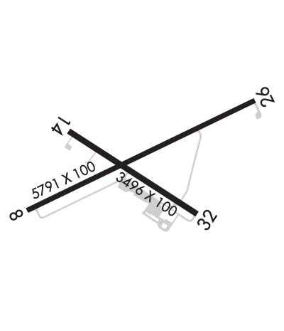
| Lat: N 4225.7 Long: W 07317.5 Elev: 1188 Var: +15 Longest Runway: 5791 | ||
| Clr Del: 128.6 AWOS: 135.37 CTAF: 122.7 | ||
| ||||||||||||||||||||||||||||||||||||||||||||
| ||||||||||||||||||||||||||||||||||||||||||||
| ||||||||||||||||||||||||||||||||||||||||||||
| Rwy | Rwy | |||||||
| 5791x100 | 5791' | 5791x100 | 5791' | 108.30 - 259° | ||||
| 3496x100 | 3496' | 3496x100 | 3496' | |||||
| Runway ID | Single Wheel | Double Wheel | Double Tandem Wheel | Dual Double Wheel |
| 08/26 | 44,000 | 54,000 | N/A | N/A |
| 14/32 | 25,000 | N/A | N/A | N/A |
| These numbers are Advisory and are not limits. The Airport Manager should have more accurate Weight Limits | ||||
 Airport Diagram might not be current. | |
| Facility Name: | PITTSFIELD MUNI |
| City Name: | PITTSFIELD |
| County: | BERKSHIRE |
| State abbrev: | MA |
| State Name: | MASSACHUSETTS |
| Ownership: | PUBLICLY OWNED |
| Use: | OPEN TO THE PUBLIC |
| Owner's Name: | CITY OF PITTSFIELD |
| Address: | 70 ALLEN ST |
| PITTSFIELD, MA 01201 | |
| Owner's Phone: | 413-448-9790 |
| Manager's Name: | DANIEL SHEARER |
| Address: | PITTSFIELD MUNICIPAL AIRPORT, 832 TAMARACK ROAD |
| PITTSFIELD, MA 01201 | |
| Phone: | 413-448-9790 |
| FAA Region: | NEW ENGLAND |
| FAA Field Office: | NONE |
| Date | Sunrise | Sunset |
|---|---|---|
| 09/24/21 Friday | 6:42 | 18:47 |
| 09/25/21 Saturday | 6:43 | 18:46 |
| 09/26/21 Sunday | 6:44 | 18:44 |
| 09/27/21 Monday | 6:46 | 18:42 |
| 09/28/21 Tuesday | 6:47 | 18:40 |
| 09/29/21 Wednesday | 6:48 | 18:39 |
| 09/30/21 Thursday | 6:49 | 18:37 |
| 10/01/21 Friday | 6:50 | 18:35 |
| 10/02/21 Saturday | 6:51 | 18:33 |
| 10/03/21 Sunday | 6:52 | 18:32 |
| 10/04/21 Monday | 6:53 | 18:30 |
| 10/05/21 Tuesday | 6:54 | 18:28 |
| 10/06/21 Wednesday | 6:55 | 18:26 |
| 10/07/21 Thursday | 6:57 | 18:25 |
| Airport Attendance Schedule | MON-FRI 0700-2000, SAT 0800-1700, SUN 0800-1700 |
| Airport Status | OPERATIONAL (This Status can change at any time - please check NOTAMS) |
| Airport Lighting Schedule | ACTVT REIL RWY 26; PAPI RWY 26; MIRL RWY 08/26 & 14/32 - CTAF. |
| Airport Storage Available | Tie Downs, Hanger |
| Extra Services Available | Charter, Flight Instruction, Aircraft Rental, Aircraft Sales |
| Wind Indicator | YES - (unlit) |
| Control Tower | NO |
| CTAF Frequency | 122.700 |
| Unicom Frequency | 122.700 |
| Rotating Beacon Color | CLEAR-GREEN (Light Land Airport) |
| Segmented Circle | YES |
| Landing Fee | NO |
| Airport Inspected | STATE - performed by STATE AERONAUTICAL PERSONNEL |
| Inspection Date | 08/28/2019 |
| Type of Fuel Available | Grade 100LL, JET A (freeze point -40C) |
| Airframe Repair Service | MAJOR |
| Power Plant Repair Service | MAJOR |
| Latitude | N4225.7 |
| Longitude | W07317.5 (ESTIMATED) |
| Arpt Elevation | 1188ft (SURVEYED) |
| Magnetic Variation | 15W |
| 2 miles W | of PITTSFIELD |
| Traffic Pattern Altitude | |
| Sectional Chart | NEW YORK |
| Operations (Reported) | Yearly | Avg. Daily |
|---|---|---|
| General Aviation Transient | 9000 | 25 |
| General Aviation Local | 20000 | 55 |
| Air Taxi | 3700 | 10 |
| Commerical | 0 | 0 |
| Commuter | 0 | 0 |
| Military | 1000 | 3 |
| Aircraft based on Field | |
|---|---|
| General Aviation Singles | 18 |
| General Aviation Multi | 5 |
| Jet Aircraft | 9 |
| General Aviation Helicopters | 0 |
| Military Aircraft | 0 |
| Gliders | 0 |
| Ultralights | 0 |
| FSS on field | NO |
| FSS tie-in | BURLINGTON |
| FSS Phone | 1-800-WX-BRIEF |
| Who issues Notams | PSF |
| Notam D service at airport | YES |
| ARTCC Name | BOSTON |
| Airport Certification | |
| Aircraft Rescue & Firefighting Index | None |
| Airport of Entry | No |
| Custom Landing Rights | YES; LDG & PRKG FEES. |
| Joint Civil/Military | No |
| Military Landing rights | YES |
| NATIONAL PLAN OF INTEGRATED AIRPORT SYSTEMS (NPIAS) |
| GRANT AGREEMENTS UNDER FAAP/ADAP/AIP |
| ASSURANCES PURSUANT TO TITLE VI, CIVIL RIGHTS ACT OF 1964 |
| OBSTN LGTD POLES 5600 FT SE AT 1960 FT; 10200 FT SW AT 2171 FT; 14100 FT NW AT 1890 FT; 7600 FT NE AT 1330 FT; 6600 FT SE AT 1470 FT. |
| VOLUNTARY CURFEW 11PM TO 7AM. |
| AFT BACK TAX RWY 26 USE TWY 'D' TO TURN AROUND. |
| FOR CD CTC ALBANY APCH AT 518-862-2299. |
| FOR AFT HRS FUEL CALL FBO 413-443-6700. |
| WILDLIFE AND GEESE ON & INVOF ARPT. |
| ALL ACFT UTILIZE TWY SYS 'A', 'C' & 'D' FOR RWY 08/26.TWY 'A' USE RSTD TO ACFT WITH WINGSPAN LESS THAN 79 FT. |
| CHECK NOTAMS FOR ARPT CONDITIONS. AIRFIELD SFC CONDITIONS NOT MONITORED AND SNOW REMOVAL NOT GUARANTEED BETWEEN THE HOURS OF 2030 - 1200Z. |
| NOISE ABATEMENT PROCS IN EFCT CTC ARPT MGR 413-448-9790. |
| FBO ATNDD. |
Airport Communications & Frequencies:
| ||||||||||||||||
| Runway: 08 | Runway: 26 | ||
| Mag heading: | 79° | Mag heading: | 259° |
| Rwy Slope: | -.97% Down | Rwy Slope: | .97% Up |
| Approach: | Approach: | LOC/DME | |
| Pattern: | Left Traffic | Pattern: | Right Traffic |
| Markings: | PRECISION INSTRUMENT | Markings: | PRECISION INSTRUMENT |
| Marking Condition: | GOOD | Marking Condition: | GOOD |
| Arresting Dev: | Arresting Dev: | ||
| Lat & Long: | N4225.5 W07318.0 | Lat. & Long.: | N4225.9 W07316.9 |
| Elev: | 1188.4 ft. MSL | Elev: | 1132.1 ft. MSL |
| TCH: | TCH: | 50 ft. AGL | |
| Visual Glide Path: | Visual Glide Path: | 3.00 degrees | |
| Displaced Threshold: | No | Displaced Threshold: | No |
| Touchdown Zone: | YES | Touchdown Zone: | YES |
| Touchdown Elev.: | 1188.4 feet | Touchdown Elev.: | 1159.3 feet |
| Visual Glide Slope: | Visual Glide Slope: | 4-Light PAPI on LEFT side of Runway | |
| RVR Equipment: | RVR Equipment: | ||
| RVV Equipment: | NO | RVV Equipment: | NO |
| Approach Lights: | Approach Lights: | ||
| REIL: | NO | REIL: | YES |
| Centerline Lights: | NO | Centerline Lights: | NO |
| Touchdown lights: | NO | Touchdown lights: | NO |
| Runway Category: | Runway with a Non-precision Approach having visibility minimums greater than 3/4 mile | Runway Category: | D |
| Declared Distances: | Declared Distances: | ||
| Obstructions: | TREES | Obstructions: | TREES |
| Marked: | LIGHTED | Marked: | NOT Marked/Lighted |
| Clearance slope: | 11:1 | Clearance slope: | 20:1 |
| Obstruction height: | 84 feet AGL | Obstruction height: | 38 feet AGL |
| Dist. from runway: | 1124 feet | Dist. from runway: | 950 feet |
| Centerline offset: | 434 right of centerline | Centerline offset: | 466 feet left of centerline |
| Comments: | Comments: |
| Runway: 14 | Runway: 32 | ||
| Mag heading: | 138° | Mag heading: | 318° |
| Rwy Slope: | -.82% Down | Rwy Slope: | .82% Up |
| Approach: | Approach: | ||
| Pattern: | Left Traffic | Pattern: | Right Traffic |
| Markings: | BASIC | Markings: | BASIC |
| Marking Condition: | GOOD | Marking Condition: | GOOD |
| Arresting Dev: | Arresting Dev: | ||
| Lat & Long: | N4225.8 W07317.8 | Lat. & Long.: | N4225.5 W07317.2 |
| Elev: | 1170.3 ft. MSL | Elev: | 1141.8 ft. MSL |
| TCH: | TCH: | ||
| Visual Glide Path: | Visual Glide Path: | ||
| Displaced Threshold: | No | Displaced Threshold: | No |
| Touchdown Zone: | YES | Touchdown Zone: | YES |
| Touchdown Elev.: | 1170.3 feet | Touchdown Elev.: | 1167.8 feet |
| Visual Glide Slope: | Visual Glide Slope: | ||
| RVR Equipment: | RVR Equipment: | ||
| RVV Equipment: | NO | RVV Equipment: | NO |
| Approach Lights: | Approach Lights: | ||
| REIL: | NO | REIL: | NO |
| Centerline Lights: | NO | Centerline Lights: | NO |
| Touchdown lights: | NO | Touchdown lights: | NO |
| Runway Category: | Runway with a Visual Approach | Runway Category: | Runway with a Visual Approach |
| Declared Distances: | Declared Distances: | ||
| Obstructions: | TREES | Obstructions: | TREES |
| Marked: | NOT Marked/Lighted | Marked: | NOT Marked/Lighted |
| Clearance slope: | 16:1 | Clearance slope: | 20:1 |
| Obstruction height: | 50 feet AGL | Obstruction height: | 20 feet AGL |
| Dist. from runway: | 1000 feet | Dist. from runway: | 600 feet |
| Centerline offset: | 125 left of centerline | Centerline offset: | 120 feet left of centerline |
| Comments: | Comments: |
Thanks for using FltPlan.com
all rights reserved © 1999-2021 by Flight Plan LLC
