| TRI-CITIES PASCO WA |
| |
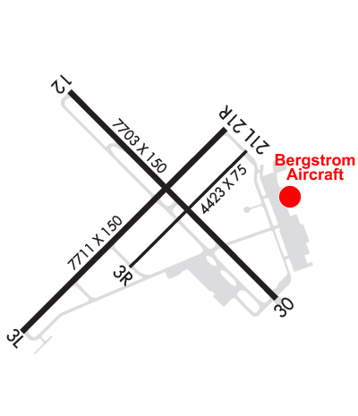
| Lat: N 4615.9 Long: W 11907.1 Elev: 410 Var: -15 Longest Runway: 7707 | ||
| Clr Del: 120.0 Dept. ATIS: 125.65 Arr. ATIS: 125.65 Ground: 121.8 Tower: 135.3 | ||
| |||||||||||||||||||||||||||||||||||||||||||||||||||||||||||||||||||||
| |||||||||||||||||||||||||||||||||||||||||||||||||||||||||||||||||||||
| |||||||||||||||||||||||||||||||||||||||||||||||||||||||||||||||||||||
| |||||||||||||||||||||||||||||||||||||||||||||||||||||||||||||||||||||
| |||||||||||||||||||||||||||||||||||||||||||||||||||||||||||||||||||||
| Rwy | Rwy | |||||||
| 7707x150 | 7707' | 7707x150 | 7110' | 108.70 - 210° | ||||
| 4423x75 | 4423' | 4423x75 | 4423' | |||||
| 7704x150 | 7704' | 7704x150 | 7504' | |||||
| Runway ID | Single Wheel | Double Wheel | Double Tandem Wheel | Dual Double Wheel |
| 03L/21R | 150,000 | 200,000 | 400,000 | N/A |
| 03R/21L | 52,000 | 85,000 | 108,000 | 150,000 |
| 12/30 | 150,000 | 200,000 | 400,000 | N/A |
| These numbers are Advisory and are not limits. The Airport Manager should have more accurate Weight Limits | ||||
 Airport Diagram might not be current. | |
| Facility Name: | TRI-CITIES |
| City Name: | PASCO |
| County: | FRANKLIN |
| State abbrev: | WA |
| State Name: | WASHINGTON |
| Ownership: | PUBLICLY OWNED |
| Use: | OPEN TO THE PUBLIC |
| Owner's Name: | PORT OF PASCO |
| Address: | 3601 N 20TH AVE |
| PASCO, WA 99301 | |
| Owner's Phone: | 509-547-6352 |
| Manager's Name: | DONALD "BUCK" TAFT |
| Address: | 3601 N 20TH AVE |
| PASCO, WA 99301 | |
| Phone: | 509-547-6352 |
| FAA Region: | NORTHWEST MOUNTAIN |
| FAA Field Office: | SEA |
| Date | Sunrise | Sunset |
|---|---|---|
| 09/24/21 Friday | 6:46 | 18:50 |
| 09/25/21 Saturday | 6:47 | 18:48 |
| 09/26/21 Sunday | 6:48 | 18:46 |
| 09/27/21 Monday | 6:50 | 18:45 |
| 09/28/21 Tuesday | 6:51 | 18:43 |
| 09/29/21 Wednesday | 6:52 | 18:41 |
| 09/30/21 Thursday | 6:53 | 18:39 |
| 10/01/21 Friday | 6:55 | 18:37 |
| 10/02/21 Saturday | 6:56 | 18:35 |
| 10/03/21 Sunday | 6:57 | 18:33 |
| 10/04/21 Monday | 6:59 | 18:31 |
| 10/05/21 Tuesday | 7:00 | 18:29 |
| 10/06/21 Wednesday | 7:01 | 18:27 |
| 10/07/21 Thursday | 7:03 | 18:25 |
| Airport Attendance Schedule | 7 Days A Week 0800-2000 |
| Airport Status | OPERATIONAL (This Status can change at any time - please check NOTAMS) |
| Airport Lighting Schedule | WHEN ATCT CLSD HIRL RY 03L/21R AND MIRL RY 12/30 PRESET ON LOW INTST TO INCREASE INTST AND ACTVT MALSR RY 21R & ODALS RY 30 - CTAF. |
| Airport Storage Available | Tie Downs, Hanger |
| Extra Services Available | Air Freight, Air Ambulance, Avionics, Cargo Handling, Charter, Flight Instruction, Aircraft Rental, Aircraft Sales, Annual Surveying |
| Wind Indicator | YES - (lighted) |
| Control Tower | YES |
| CTAF Frequency | 135.300 |
| Unicom Frequency | 122.950 |
| Rotating Beacon Color | CLEAR-GREEN (Light Land Airport) |
| Segmented Circle | YES |
| Landing Fee | NO |
| Airport Inspected | FEDERAL - performed by FAA AIRPORTS FIELD PERSONNEL |
| Inspection Date | 04/03/2019 |
| Type of Fuel Available | Grade 100LL, JET A-1 (icing inhibitor, freeze point -50C); -10AFTER HOURS FUEL CALL (509) 547-6271 OR (509) 545-5524. CALL-OUT FEE. FUEL 24 HR CREDIT CARD SVC AVBL. |
| Airframe Repair Service | MAJOR |
| Power Plant Repair Service | MAJOR |
| Latitude | N4615.9 |
| Longitude | W11907.1 (ESTIMATED) |
| Arpt Elevation | 410ft (SURVEYED) |
| Magnetic Variation | 15E |
| 2 miles NW | of PASCO |
| Traffic Pattern Altitude | |
| Sectional Chart | SEATTLE |
| Operations (Reported) | Yearly | Avg. Daily |
|---|---|---|
| General Aviation Transient | 16541 | 45 |
| General Aviation Local | 15744 | 43 |
| Air Taxi | 4453 | 12 |
| Commerical | 9154 | 25 |
| Commuter | 0 | 0 |
| Military | 2319 | 6 |
| Aircraft based on Field | |
|---|---|
| General Aviation Singles | 80 |
| General Aviation Multi | 23 |
| Jet Aircraft | 14 |
| General Aviation Helicopters | 4 |
| Military Aircraft | 0 |
| Gliders | 0 |
| Ultralights | 0 |
| FSS on field | NO |
| FSS tie-in | SEATTLE |
| FSS Phone | 1-800-WX-BRIEF |
| Who issues Notams | PSC |
| Notam D service at airport | YES |
| ARTCC Name | SEATTLE |
| Airport Certification | AIRPORT RECEIVING SCHEDULED AIR CARRIER SERVICE FROM CARRIERS CERTIFICATED BY THE CIVIL AERONAUTICS BOARD; PPR UNSKED ACR OPNS WITH MORE THAN 30 PSGR SEATS CALL AMGR 509-547-6352. |
| Aircraft Rescue & Firefighting Index | AIRPORT HAS A CERTIFICATE UNDER CFR PART 139 |
| Airport of Entry | No |
| Custom Landing Rights | No |
| Joint Civil/Military | No |
| Military Landing rights | YES |
| NATIONAL PLAN OF INTEGRATED AIRPORT SYSTEMS (NPIAS) |
| GRANT AGREEMENTS UNDER FAAP/ADAP/AIP |
| SURPLUS PROPERTY AGREEMENT UNDER PUBLIC LAW 289 |
| ASSURANCES PURSUANT TO TITLE VI, CIVIL RIGHTS ACT OF 1964 |
| BIRD HAZARD; SEE SPECIAL NOTICE FOR WASHINGTON IN AIM PART 3A. |
| TPA 1500' TURBINE PWRD ACFT; ALL OTRS 1000'. |
| RY 03R/21L IS AVBL FOR ACR ACFT FOR TAXIING DURING DALGT AND VFR CONDITIONS ONLY. |
| RY 21L & 03R NOT AVBL AS MOVEMENT AREA FOR ACR ACFT WITH MORE THAN 9 PSGR SEATS OR GREATER FOR LNDG AND TKOF. |
| WATER FOWL ON & INVOF ARPT SPRING & FALL. |
| RWY 03R/ 21LRY 03R/21L SFC CRACKING. |
Airport Communications & Frequencies:
| |||||||||||||||||||||||||||||||||||
| Runway: 03L | Runway: 21R | ||
| Mag heading: | 30° | Mag heading: | 210° |
| Rwy Slope: | -.11% Down | Rwy Slope: | .11% Up |
| Approach: | Approach: | ILS/DME | |
| Pattern: | Left Traffic | Pattern: | Right Traffic |
| Markings: | NONPRECISION INSTRUMENT | Markings: | PRECISION INSTRUMENT |
| Marking Condition: | GOOD | Marking Condition: | GOOD |
| Arresting Dev: | Arresting Dev: | ||
| Lat & Long: | N4615.4 W11908.0 | Lat. & Long.: | N4616.2 W11906.7 |
| Elev: | 409.8 ft. MSL | Elev: | 401.3 ft. MSL |
| TCH: | 49 ft. AGL | TCH: | 54 ft. AGL |
| Visual Glide Path: | 3.00 degrees | Visual Glide Path: | 3.00 degrees |
| Displaced Threshold: | No | Displaced Threshold: | 597 feet |
| Touchdown Zone: | YES | Touchdown Zone: | YES |
| Touchdown Elev.: | 410.4 feet | Touchdown Elev.: | 403.4 feet |
| Visual Glide Slope: | 4-Light PAPI on LEFT side of Runway | Visual Glide Slope: | 4-Light PAPI on LEFT side of Runway |
| RVR Equipment: | ROLLOUT | RVR Equipment: | TOUCHDOWN |
| RVV Equipment: | NO | RVV Equipment: | NO |
| Approach Lights: | Approach Lights: | MALSR - 1,400 foot medium intensity approach lighting system with runway alignment indicator lights | |
| REIL: | YES | REIL: | NO |
| Centerline Lights: | NO | Centerline Lights: | NO |
| Touchdown lights: | NO | Touchdown lights: | NO |
| Runway Category: | D | Runway Category: | Precision Instrument Runway |
| Declared Distances: | TORA:7707' TODA:7707' ASDA:7707' LDA:7707' | Declared Distances: | TORA:7707' TODA:7707' ASDA:7707' LDA:7110' |
| Obstructions: | TREE | Obstructions: | POLE |
| Marked: | NOT Marked/Lighted | Marked: | NOT Marked/Lighted |
| Clearance slope: | 38:1 | Clearance slope: | 34:1; +81' TWR 3036' & 900'L 37:1 BASED ON DSPLCD THR. |
| Obstruction height: | 61 feet AGL | Obstruction height: | 49 feet AGL |
| Dist. from runway: | 2550 feet | Dist. from runway: | 1900 feet |
| Centerline offset: | 750 right of centerline | Centerline offset: | 450 feet left of centerline |
| Comments: | Comments: |
| Runway: 03R | Runway: 21L | ||
| Mag heading: | 30° | Mag heading: | 210° |
| Rwy Slope: | .02% Up | Rwy Slope: | -.02% Down |
| Approach: | Approach: | ||
| Pattern: | Right Traffic | Pattern: | Left Traffic |
| Markings: | BASIC | Markings: | BASIC |
| Marking Condition: | GOOD | Marking Condition: | GOOD |
| Arresting Dev: | Arresting Dev: | ||
| Lat & Long: | N4615.6 W11907.3 | Lat. & Long.: | N4616.1 W11906.6 |
| Elev: | 402.9 ft. MSL | Elev: | 403.8 ft. MSL |
| TCH: | TCH: | ||
| Visual Glide Path: | Visual Glide Path: | ||
| Displaced Threshold: | No | Displaced Threshold: | No |
| Touchdown Zone: | YES | Touchdown Zone: | YES |
| Touchdown Elev.: | 404.7 feet | Touchdown Elev.: | 404.7 feet |
| Visual Glide Slope: | Visual Glide Slope: | ||
| RVR Equipment: | RVR Equipment: | ||
| RVV Equipment: | NO | RVV Equipment: | NO |
| Approach Lights: | Approach Lights: | ||
| REIL: | NO | REIL: | NO |
| Centerline Lights: | NO | Centerline Lights: | NO |
| Touchdown lights: | NO | Touchdown lights: | NO |
| Runway Category: | Runway with a Visual Approach | Runway Category: | Runway with a Visual Approach |
| Declared Distances: | TORA:4423' TODA:4423' ASDA:4423' LDA:4423' | Declared Distances: | TORA:4423' TODA:4423' ASDA:4423' LDA:4423' |
| Obstructions: | Obstructions: | TOWER | |
| Marked: | Marked: | NOT Marked/Lighted | |
| Clearance slope: | 50:1 | Clearance slope: | 28:1 |
| Obstruction height: | Obstruction height: | 79 feet AGL | |
| Dist. from runway: | Dist. from runway: | 2445 feet | |
| Centerline offset: | Centerline offset: | 77 feet left of centerline | |
| Comments: | Comments: |
| Runway: 12 | Runway: 30 | ||
| Mag heading: | 120° | Mag heading: | 300° |
| Rwy Slope: | .08% Up | Rwy Slope: | -.08% Down |
| Approach: | Approach: | ||
| Pattern: | Left Traffic | Pattern: | Left Traffic |
| Markings: | NONPRECISION INSTRUMENT | Markings: | NONPRECISION INSTRUMENT |
| Marking Condition: | GOOD | Marking Condition: | GOOD |
| Arresting Dev: | Arresting Dev: | ||
| Lat & Long: | N4616.4 W11907.7 | Lat. & Long.: | N4615.5 W11906.4 |
| Elev: | 395.6 ft. MSL | Elev: | 402.0 ft. MSL |
| TCH: | 56 ft. AGL | TCH: | 54 ft. AGL |
| Visual Glide Path: | 3.00 degrees | Visual Glide Path: | 3.00 degrees |
| Displaced Threshold: | No | Displaced Threshold: | 200 feet |
| Touchdown Zone: | YES | Touchdown Zone: | YES |
| Touchdown Elev.: | 401.8 feet | Touchdown Elev.: | 405.2 feet |
| Visual Glide Slope: | 4-BOX VASI ON LEFT SIDE OF RUNWAY | Visual Glide Slope: | 4-Light PAPI on LEFT side of Runway |
| RVR Equipment: | RVR Equipment: | ||
| RVV Equipment: | NO | RVV Equipment: | NO |
| Approach Lights: | Approach Lights: | ODALS - omnidirectional approach lighting system | |
| REIL: | YES | REIL: | NO |
| Centerline Lights: | NO | Centerline Lights: | NO |
| Touchdown lights: | NO | Touchdown lights: | NO |
| Runway Category: | D | Runway Category: | D |
| Declared Distances: | TORA:7704' TODA:7704' ASDA:7504' LDA:7504' | Declared Distances: | TORA:7704' TODA:7704' ASDA:7704' LDA:7504' |
| Obstructions: | Obstructions: | TREE | |
| Marked: | Marked: | NOT Marked/Lighted | |
| Clearance slope: | 50:1 | Clearance slope: | 37:1 |
| Obstruction height: | Obstruction height: | 30 feet AGL | |
| Dist. from runway: | Dist. from runway: | 1312 feet | |
| Centerline offset: | Centerline offset: | 177 feet left of centerline | |
| Comments: | Comments: |
Thanks for using FltPlan.com
all rights reserved © 1999-2021 by Flight Plan LLC