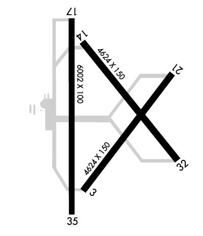
Runway Identification: 03/21Length: 4624 ft
Width: 150 ft
Surface: CONCRETE-POOR CONDITION
Edge lights: Treatment: NONE
| | Runway: 03 | | Runway: 21 |
| Mag heading: | 33° | Mag heading: | 213° |
| Rwy Slope: | .34% Up | Rwy Slope: | -.34% Down |
| Approach: | | Approach: | |
| Pattern: | Left Traffic | Pattern: | Left Traffic |
| Markings: | BASIC | Markings: | BASIC |
| Marking Condition: | POOR; MKGS FADED. | Marking Condition: | POOR; MKGS FADED. |
| Arresting Dev: | | Arresting Dev: | |
| Lat & Long: | N3337.8 W09527.2 | Lat. & Long.: | N3338.4 W09526.6 |
| Elev: | 530.3 ft. MSL | Elev: | 546.2 ft. MSL |
| TCH: | | TCH: | |
| Visual Glide Path: | | Visual Glide Path: | |
| Displaced Threshold: | No | Displaced Threshold: | No |
| Touchdown Zone: | YES | Touchdown Zone: | YES |
| Touchdown Elev.: | 545.7 feet | Touchdown Elev.: | 546.2 feet |
| Visual Glide Slope: | | Visual Glide Slope: | |
| RVR Equipment: | | RVR Equipment: | |
| RVV Equipment: | NO | RVV Equipment: | NO |
| Approach Lights: | | Approach Lights: | |
| REIL: | NO | REIL: | NO |
| Centerline Lights: | NO | Centerline Lights: | NO |
| Touchdown lights: | NO | Touchdown lights: | NO |
| Runway Category: | Runway with a Visual Approach | Runway Category: | Runway with a Visual Approach |
| Declared Distances: | TORA:4624' TODA:4624' ASDA:4624' LDA:4624' | Declared Distances: | TORA:4624' TODA:4624' ASDA:4624' LDA:4624' |
| Obstructions: | TREES | Obstructions: | TREES |
| Marked: | NOT Marked/Lighted | Marked: | NOT Marked/Lighted |
| Clearance slope: | 23:1 | Clearance slope: | 11:1 |
| Obstruction height: | 28 feet AGL | Obstruction height: | 18 feet AGL |
| Dist. from runway: | 860 feet | Dist. from runway: | 407 feet |
| Centerline offset: | 185 left of centerline | Centerline offset: | 135 feet right of centerline |
| Comments: | | Comments: | 40 FT TREES 132 FT DSTC, 245 FT L |
Runway Identification: 14/32Length: 4624 ft
Width: 150 ft
Surface: CONCRETE-FAIR CONDITION
Edge lights: Treatment: NONE
| | Runway: 14 | | Runway: 32 |
| Mag heading: | 137° | Mag heading: | 317° |
| Rwy Slope: | .17% Up | Rwy Slope: | -.17% Down |
| Approach: | | Approach: | |
| Pattern: | Left Traffic | Pattern: | Left Traffic |
| Markings: | BASIC | Markings: | BASIC |
| Marking Condition: | FAIR | Marking Condition: | FAIR |
| Arresting Dev: | | Arresting Dev: | |
| Lat & Long: | N3338.6 W09527.2 | Lat. & Long.: | N3338.0 W09526.6 |
| Elev: | 539.5 ft. MSL | Elev: | 547.3 ft. MSL |
| TCH: | | TCH: | |
| Visual Glide Path: | | Visual Glide Path: | |
| Displaced Threshold: | No | Displaced Threshold: | No |
| Touchdown Zone: | YES | Touchdown Zone: | YES |
| Touchdown Elev.: | 547.6 feet | Touchdown Elev.: | 547.5 feet |
| Visual Glide Slope: | | Visual Glide Slope: | |
| RVR Equipment: | | RVR Equipment: | |
| RVV Equipment: | NO | RVV Equipment: | NO |
| Approach Lights: | | Approach Lights: | |
| REIL: | NO | REIL: | NO |
| Centerline Lights: | NO | Centerline Lights: | NO |
| Touchdown lights: | NO | Touchdown lights: | NO |
| Runway Category: | Runway with a Visual Approach | Runway Category: | Runway with a Visual Approach |
| Declared Distances: | TORA:4624' TODA:4624' ASDA:4624' LDA:4624' | Declared Distances: | TORA:4624' TODA:4624' ASDA:4624' LDA:4624' |
| Obstructions: | TREES | Obstructions: | |
| Marked: | NOT Marked/Lighted | Marked: | |
| Clearance slope: | 8:1 | Clearance slope: | 50:1 |
| Obstruction height: | 30 feet AGL | Obstruction height: | |
| Dist. from runway: | 455 feet | Dist. from runway: | |
| Centerline offset: | 245 left of centerline | Centerline offset: | |
| Comments: | 10 FT BRUSH, 30 FT DSTC, 244 FT L. | Comments: | |
Runway Identification: 17/35Length: 6002 ft
Width: 100 ft
Surface: ASPHALT-GOOD CONDITION
Edge lights: Medium IntensityTreatment: NONE
| | Runway: 17 | | Runway: 35 |
| Mag heading: | 175° | Mag heading: | 355° |
| Rwy Slope: | -.24% Down | Rwy Slope: | .24% Up |
| Approach: | | Approach: | |
| Pattern: | Left Traffic | Pattern: | Left Traffic |
| Markings: | NONPRECISION INSTRUMENT | Markings: | NONPRECISION INSTRUMENT |
| Marking Condition: | GOOD | Marking Condition: | GOOD |
| Arresting Dev: | | Arresting Dev: | |
| Lat & Long: | N3338.7 W09527.3 | Lat. & Long.: | N3337.7 W09527.2 |
| Elev: | 541.0 ft. MSL | Elev: | 526.3 ft. MSL |
| TCH: | 40 ft. AGL | TCH: | 40 ft. AGL |
| Visual Glide Path: | 3.00 degrees | Visual Glide Path: | 3.00 degrees |
| Displaced Threshold: | No | Displaced Threshold: | No |
| Touchdown Zone: | YES | Touchdown Zone: | YES |
| Touchdown Elev.: | 541.0 feet | Touchdown Elev.: | 532.3 feet |
| Visual Glide Slope: | 4-Light PAPI on LEFT side of Runway | Visual Glide Slope: | 4-Light PAPI on LEFT side of Runway |
| RVR Equipment: | | RVR Equipment: | |
| RVV Equipment: | NO | RVV Equipment: | NO |
| Approach Lights: | | Approach Lights: | |
| REIL: | NO | REIL: | NO |
| Centerline Lights: | NO | Centerline Lights: | NO |
| Touchdown lights: | NO | Touchdown lights: | NO |
| Runway Category: | Runway with a Non-precision Approach having visibility minimums greater than 3/4 mile | Runway Category: | D |
| Declared Distances: | TORA:6002' TODA:6002' ASDA:6002' LDA:6002' | Declared Distances: | TORA:6002' TODA:6002' ASDA:6002' LDA:6002' |
| Obstructions: | | Obstructions: | TREES |
| Marked: | | Marked: | NOT Marked/Lighted |
| Clearance slope: | 34:1 | Clearance slope: | 3:1 |
| Obstruction height: | | Obstruction height: | 37 feet AGL |
| Dist. from runway: | | Dist. from runway: | 325 feet |
| Centerline offset: | | Centerline offset: | 260 feet left of centerline |
| Comments: | 39 FT TREES, 100 FT DSTC, 390 FT L. | Comments: | 20 FT TREES, 0-199 FT DSTC, 250 L. |
Runway Identification: H1 HELIPADLength: 40 ft
Width: 40 ft
Surface: CONCRETE-GOOD CONDITION
Edge lights:
Treatment: NONE