
| PASO ROBLES MUNI PASO ROBLES CA |
| |
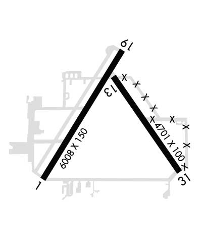
| Lat: N 3540.4 Long: W 12037.6 Elev: 839 Var: -15 Longest Runway: 6008 | ||
| AWOS: 120.12 CTAF: 123.0 | ||
| ||||||||||||||||||||||||||||||||||||||||||||
| ||||||||||||||||||||||||||||||||||||||||||||
| ||||||||||||||||||||||||||||||||||||||||||||
| Rwy | Rwy | |||||||
| 6008x150 | 6008' | 6008x150 | 6008' | |||||
| 4701x100 | 4701' | 4701x100 | 4701' | |||||
| Runway ID | Single Wheel | Double Wheel | Double Tandem Wheel | Dual Double Wheel |
| 01/19 | 60,000 | 106,000 | 150,000 | N/A |
| 13/31 | 30,000 | 50,000 | 90,000 | N/A |
| H1 | N/A | N/A | N/A | N/A |
| These numbers are Advisory and are not limits. The Airport Manager should have more accurate Weight Limits | ||||
 Airport Diagram might not be current. | |
| Facility Name: | PASO ROBLES MUNI |
| City Name: | PASO ROBLES |
| County: | SAN LUIS OBISPO |
| State abbrev: | CA |
| State Name: | CALIFORNIA |
| Ownership: | PUBLICLY OWNED |
| Use: | OPEN TO THE PUBLIC |
| Owner's Name: | CITY OF PASO ROBLES |
| Address: | 1000 SPRING ST. |
| PASO ROBLES, CA 93446 | |
| Owner's Phone: | 805-237-3861 |
| Manager's Name: | MARK W. SCANDALIS |
| Address: | 4912 WING WAY |
| PASO ROBLES, CA 93446 | |
| Phone: | 805-237-3877 |
| FAA Region: | WESTERN-PACIFIC |
| FAA Field Office: | SFO |
| Date | Sunrise | Sunset |
|---|---|---|
| 06/08/26 Monday | 5:46 | 20:17 |
| 06/09/26 Tuesday | 5:46 | 20:17 |
| 06/10/26 Wednesday | 5:46 | 20:18 |
| 06/11/26 Thursday | 5:46 | 20:18 |
| 06/12/26 Friday | 5:46 | 20:19 |
| 06/13/26 Saturday | 5:46 | 20:19 |
| 06/14/26 Sunday | 5:46 | 20:20 |
| 06/15/26 Monday | 5:46 | 20:20 |
| 06/16/26 Tuesday | 5:46 | 20:20 |
| 06/17/26 Wednesday | 5:46 | 20:21 |
| 06/18/26 Thursday | 5:46 | 20:21 |
| 06/19/26 Friday | 5:47 | 20:21 |
| 06/20/26 Saturday | 5:47 | 20:21 |
| 06/21/26 Sunday | 5:47 | 20:22 |
| Airport Attendance Schedule | 7 Days A Week 0700-1800; FEE FOR CALL OUT SVC OTR HRS, 805-246-1443. |
| Airport Status | OPERATIONAL (This Status can change at any time - please check NOTAMS) |
| Airport Lighting Schedule | RY LGTS OPER DUSK-2200; AFTER 2200 ACTVT HIRL RY 01/19 MIRL RY 13/31 PAPI RYS 19 & 31, RY H1 PERIMETER LGTS - CTAF. |
| Airport Storage Available | Tie Downs |
| Extra Services Available | Flight Instruction, Aircraft Rental |
| Wind Indicator | YES - (lighted) |
| Control Tower | NO |
| CTAF Frequency | 123.000 |
| Unicom Frequency | 123.000 |
| Rotating Beacon Color | WG |
| Segmented Circle | YES |
| Landing Fee | NO |
| Airport Inspected | FEDERAL - performed by STATE AERONAUTICAL PERSONNEL; MSCANDALIS@PRCITY.COM |
| Inspection Date | 12/03/2025 |
| Type of Fuel Available | Grade 100LL, JET A (freeze point -40C) |
| Airframe Repair Service | MAJOR |
| Power Plant Repair Service | MINOR |
| Latitude | N3540.4 |
| Longitude | W12037.6 (ESTIMATED) |
| Arpt Elevation | 838ft (SURVEYED) |
| Magnetic Variation | 15E |
| 4 miles NE | of PASO ROBLES |
| Traffic Pattern Altitude | |
| Sectional Chart | LOS ANGELES |
| Operations (Reported) | Yearly | Avg. Daily |
|---|---|---|
| General Aviation Transient | 0 | 0 |
| General Aviation Local | 0 | 0 |
| Air Taxi | 0 | 0 |
| Commerical | 0 | 0 |
| Commuter | 0 | 0 |
| Military | 0 | 0 |
| Aircraft based on Field | |
|---|---|
| General Aviation Singles | 0 |
| General Aviation Multi | 0 |
| Jet Aircraft | 0 |
| General Aviation Helicopters | 0 |
| Military Aircraft | 0 |
| Gliders | 0 |
| Ultralights | 0 |
| FSS on field | NO |
| FSS tie-in | HAWTHORNE |
| FSS Phone | 1-800-WX-BRIEF |
| Who issues Notams | PRB |
| Notam D service at airport | YES |
| ARTCC Name | OAKLAND |
| Airport Certification | |
| Aircraft Rescue & Firefighting Index | None |
| Airport of Entry | No |
| Custom Landing Rights | No |
| Joint Civil/Military | No |
| Military Landing rights | YES |
| NATIONAL PLAN OF INTEGRATED AIRPORT SYSTEMS (NPIAS) |
| GRANT AGREEMENTS UNDER FAAP/ADAP/AIP |
| SURPLUS PROPERTY AGREEMENT UNDER PUBLIC LAW 289 |
| SURPLUS PROPERTY AGREEMENT UNDER REGULATION 16-WAA |
| ASSURANCES PURSUANT TO TITLE VI, CIVIL RIGHTS ACT OF 1964 |
| PPR FOR AIRCRAFT OVER 80,000 LBS. CONTACT AMGR 805-237-3877 |
| RWY 19 DSGND CALM WIND RWY. |
| FOR CD IF UNA TO CTC ON FSS FREQ, CTC OAKLAND ARTCC AT 510-745-3380. |
| V22 OSPREY ARPT OPS RSTRD TO BTN 0700 TO 1530 LOCAL. |
| V22 OSPREY OPS PPR RQRD. |
Airport Communications & Frequencies:
| |||||||||
| Runway: 01 | Runway: 19 | ||
| Mag heading: | 14° | Mag heading: | 194° |
| Rwy Slope: | -.18% Down | Rwy Slope: | .18% Up |
| Approach: | Approach: | ||
| Pattern: | Left Traffic | Pattern: | Left Traffic |
| Markings: | NONPRECISION INSTRUMENT | Markings: | NONPRECISION INSTRUMENT |
| Marking Condition: | GOOD | Marking Condition: | GOOD |
| Arresting Dev: | Arresting Dev: | ||
| Lat & Long: | N3540.0 W12038.1 | Lat. & Long.: | N3540.8 W12037.6 |
| Elev: | 814.5 ft. MSL | Elev: | 803.4 ft. MSL |
| TCH: | TCH: | 37 ft. AGL | |
| Visual Glide Path: | Visual Glide Path: | 3.00 degrees | |
| Displaced Threshold: | No | Displaced Threshold: | No |
| Touchdown Zone: | YES | Touchdown Zone: | YES |
| Touchdown Elev.: | 815.2 feet | Touchdown Elev.: | 811.8 feet |
| Visual Glide Slope: | Visual Glide Slope: | 4-Light PAPI on LEFT side of Runway | |
| RVR Equipment: | RVR Equipment: | ||
| RVV Equipment: | NO | RVV Equipment: | NO |
| Approach Lights: | Approach Lights: | ||
| REIL: | NO | REIL: | YES |
| Centerline Lights: | NO | Centerline Lights: | NO |
| Touchdown lights: | NO | Touchdown lights: | NO |
| Runway Category: | Runway with a Visual Approach | Runway Category: | Runway with a Non-precision Approach having visibility minimums greater than 3/4 mile |
| Declared Distances: | Declared Distances: |
| Runway: 13 | Runway: 31 | ||
| Mag heading: | 129° | Mag heading: | 309° |
| Rwy Slope: | .61% Up | Rwy Slope: | -.61% Down |
| Approach: | Approach: | ||
| Pattern: | Left Traffic | Pattern: | Left Traffic |
| Markings: | NONPRECISION INSTRUMENT | Markings: | NONPRECISION INSTRUMENT |
| Marking Condition: | GOOD | Marking Condition: | GOOD |
| Arresting Dev: | Arresting Dev: | ||
| Lat & Long: | N3540.6 W12037.6 | Lat. & Long.: | N3540.0 W12037.1 |
| Elev: | 810.0 ft. MSL | Elev: | 838.7 ft. MSL |
| TCH: | TCH: | 38 ft. AGL | |
| Visual Glide Path: | Visual Glide Path: | 3.00 degrees | |
| Displaced Threshold: | No | Displaced Threshold: | No |
| Touchdown Zone: | YES | Touchdown Zone: | YES |
| Touchdown Elev.: | 826.0 feet | Touchdown Elev.: | 838.7 feet |
| Visual Glide Slope: | Visual Glide Slope: | 4-Light PAPI on LEFT side of Runway | |
| RVR Equipment: | RVR Equipment: | ||
| RVV Equipment: | NO | RVV Equipment: | NO |
| Approach Lights: | Approach Lights: | ||
| REIL: | NO | REIL: | NO |
| Centerline Lights: | NO | Centerline Lights: | NO |
| Touchdown lights: | NO | Touchdown lights: | NO |
| Runway Category: | Runway with a Visual Approach | Runway Category: | Runway with a Non-precision Approach having visibility minimums greater than 3/4 mile |
| Declared Distances: | Declared Distances: | ||
| Obstructions: | Obstructions: | TREE | |
| Marked: | Marked: | NOT Marked/Lighted | |
| Clearance slope: | 50:1 | Clearance slope: | 32:1 |
| Obstruction height: | Obstruction height: | 54 feet AGL | |
| Dist. from runway: | Dist. from runway: | 1950 feet | |
| Centerline offset: | Centerline offset: | ||
| Comments: | Comments: |
Thanks for using FltPlan.com
all rights reserved © 1999-2026 by Flight Plan LLC