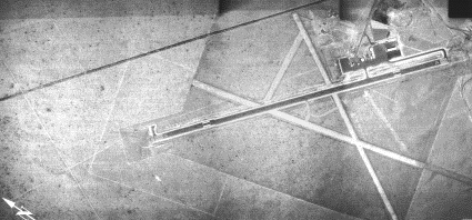
| POWELL MUNI POWELL WY |
| |
| Lat: N 4452.0 Long: W 10847.6 Elev: 5096 Var: -11 Longest Runway: 6200 | ||
| AWOS: 119.27 CTAF: 122.7 | ||
| |||||||||||||||||||||||||||||||||||||||||||||||||||||||||||||||||||||
| |||||||||||||||||||||||||||||||||||||||||||||||||||||||||||||||||||||
| |||||||||||||||||||||||||||||||||||||||||||||||||||||||||||||||||||||
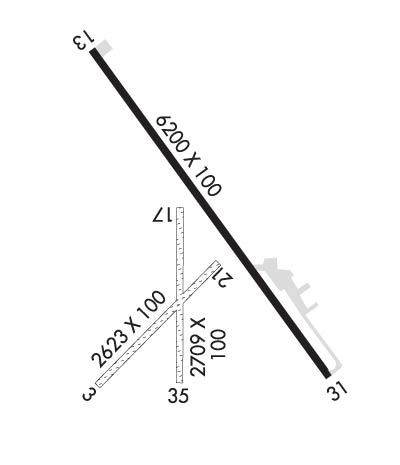
| Rwy | Rwy | |||||||
| 2623x100 | 2623' | 2623x100 | 2623' | |||||
| 6200x100 | 6200' | 6200x100 | 6200' | |||||
| 2709x100 | 2709' | 2709x100 | 2709' | |||||
| Runway ID | Single Wheel | Double Wheel | Double Tandem Wheel | Dual Double Wheel |
| 03/21 | N/A | N/A | N/A | N/A |
| 13/31 | 15,000 | N/A | N/A | N/A |
| 17/35 | N/A | N/A | N/A | N/A |
| These numbers are Advisory and are not limits. The Airport Manager should have more accurate Weight Limits | ||||
 Airport Diagram might not be current. | |
| Facility Name: | POWELL MUNI |
| City Name: | POWELL |
| County: | PARK |
| State abbrev: | WY |
| State Name: | WYOMING |
| Ownership: | PUBLICLY OWNED |
| Use: | OPEN TO THE PUBLIC |
| Owner's Name: | CITY OF POWELL |
| Address: | 270 NORTH CLARK |
| POWELL, WY 82435 | |
| Owner's Phone: | 307-754-6921 |
| Manager's Name: | SCOTT ADKINS; ALTN CTC: BEN HUBBARD CELL 307-754-5106. |
| Address: | 270 NORTH CLARK |
| POWELL, WY 82435 | |
| Phone: | 307-754-5234; CELL 307-254-1726. |
| FAA Region: | NORTHWEST MOUNTAIN |
| FAA Field Office: | DEN |
| Date | Sunrise | Sunset |
|---|---|---|
| 09/24/21 Friday | 7:04 | 19:09 |
| 09/25/21 Saturday | 7:06 | 19:07 |
| 09/26/21 Sunday | 7:07 | 19:05 |
| 09/27/21 Monday | 7:08 | 19:04 |
| 09/28/21 Tuesday | 7:09 | 19:02 |
| 09/29/21 Wednesday | 7:10 | 19:00 |
| 09/30/21 Thursday | 7:12 | 18:58 |
| 10/01/21 Friday | 7:13 | 18:56 |
| 10/02/21 Saturday | 7:14 | 18:54 |
| 10/03/21 Sunday | 7:15 | 18:52 |
| 10/04/21 Monday | 7:17 | 18:50 |
| 10/05/21 Tuesday | 7:18 | 18:49 |
| 10/06/21 Wednesday | 7:19 | 18:47 |
| 10/07/21 Thursday | 7:20 | 18:45 |
| Airport Attendance Schedule | TUE-SAT 0800-1600; FOR SVC AFTER HRS PHONE 619-518-1233. |
| Airport Status | OPERATIONAL (This Status can change at any time - please check NOTAMS) |
| Airport Lighting Schedule | ACTVT MIRL RY 13/31, REIL RY 31 AND PAPI RYS 13 & 31 - 122.7. |
| Airport Storage Available | Tie Downs, Hanger |
| Extra Services Available | NONE |
| Wind Indicator | YES - (lighted) |
| Control Tower | NO |
| CTAF Frequency | 122.700 |
| Unicom Frequency | 122.700 |
| Rotating Beacon Color | CLEAR-GREEN (Light Land Airport) |
| Segmented Circle | YES |
| Landing Fee | NO |
| Airport Inspected | STATE - performed by STATE AERONAUTICAL PERSONNEL |
| Inspection Date | 07/10/2018 |
| Type of Fuel Available | Grade 100LL, JET A (freeze point -40C); -10FUEL 24 HR CREDIT CARD SVC AVBL. |
| Airframe Repair Service | NONE |
| Power Plant Repair Service | NONE |
| Latitude | N4452.0 |
| Longitude | W10847.6 (ESTIMATED) |
| Arpt Elevation | 5095ft (SURVEYED) |
| Magnetic Variation | 11E |
| 7 miles N | of POWELL |
| Traffic Pattern Altitude | |
| Sectional Chart | BILLINGS |
| Operations (Reported) | Yearly | Avg. Daily |
|---|---|---|
| General Aviation Transient | 1300 | 4 |
| General Aviation Local | 1985 | 5 |
| Air Taxi | 100 | 0 |
| Commerical | 0 | 0 |
| Commuter | 0 | 0 |
| Military | 0 | 0 |
| Aircraft based on Field | |
|---|---|
| General Aviation Singles | 16 |
| General Aviation Multi | 0 |
| Jet Aircraft | 0 |
| General Aviation Helicopters | 0 |
| Military Aircraft | 0 |
| Gliders | 7 |
| Ultralights | 0 |
| FSS on field | NO |
| FSS tie-in | CASPER |
| FSS Phone | 1-800-WX-BRIEF |
| Who issues Notams | CPR |
| Notam D service at airport | YES |
| ARTCC Name | SALT LAKE CITY |
| Airport Certification | |
| Aircraft Rescue & Firefighting Index | None |
| Airport of Entry | No |
| Custom Landing Rights | No |
| Joint Civil/Military | No |
| Military Landing rights | YES |
| NATIONAL PLAN OF INTEGRATED AIRPORT SYSTEMS (NPIAS) |
| GRANT AGREEMENTS UNDER FAAP/ADAP/AIP |
| CONVEYANCE UNDER SCETION 16, FEDERAL AIRPORT ACT OF 1946 OR SECTION 23, AIRPORT AND AIRWAY DEVELOPMENT ACT OF 1970 |
| ASSURANCES PURSUANT TO TITLE VI, CIVIL RIGHTS ACT OF 1964 |
| AFTER HOURS EMERGENCY CONTACT POLICE DEPT. 307-754-2212 |
Airport Communications & Frequencies:
| |||||||||
| Runway: 03 | Runway: 21 | ||
| Mag heading: | 33° | Mag heading: | 213° |
| Rwy Slope: | .69% Up | Rwy Slope: | -.69% Down |
| Approach: | Approach: | ||
| Pattern: | Left Traffic | Pattern: | Left Traffic |
| Markings: | NONE | Markings: | NONE |
| Marking Condition: | FAIR | Marking Condition: | FAIR |
| Arresting Dev: | Arresting Dev: | ||
| Lat & Long: | N4451.7 W10847.9 | Lat. & Long.: | N4452.0 W10847.5 |
| Elev: | 5037.0 ft. MSL | Elev: | 5055.0 ft. MSL |
| TCH: | TCH: | ||
| Visual Glide Path: | Visual Glide Path: | ||
| Displaced Threshold: | No | Displaced Threshold: | No |
| Touchdown Zone: | YES | Touchdown Zone: | YES |
| Touchdown Elev.: | 5055.0 feet | Touchdown Elev.: | 5055.0 feet |
| Visual Glide Slope: | Visual Glide Slope: | ||
| RVR Equipment: | RVR Equipment: | ||
| RVV Equipment: | NO | RVV Equipment: | NO |
| Approach Lights: | Approach Lights: | ||
| REIL: | NO | REIL: | NO |
| Centerline Lights: | NO | Centerline Lights: | NO |
| Touchdown lights: | NO | Touchdown lights: | NO |
| Runway Category: | Runway with a Visual Approach | Runway Category: | Runway with a Visual Approach |
| Declared Distances: | Declared Distances: | ||
| Obstructions: | FENCE | Obstructions: | |
| Marked: | NOT Marked/Lighted | Marked: | |
| Clearance slope: | 21:1 | Clearance slope: | 50:1 |
| Obstruction height: | 12 feet AGL | Obstruction height: | |
| Dist. from runway: | 252 feet | Dist. from runway: | |
| Centerline offset: | 21 right of centerline | Centerline offset: | |
| Comments: | Comments: |
| Runway: 13 | Runway: 31 | ||
| Mag heading: | 134° | Mag heading: | 314° |
| Rwy Slope: | 1.59% Up | Rwy Slope: | -1.59% Down |
| Approach: | Approach: | ||
| Pattern: | Left Traffic | Pattern: | Left Traffic |
| Markings: | NONPRECISION INSTRUMENT | Markings: | NONPRECISION INSTRUMENT |
| Marking Condition: | GOOD | Marking Condition: | GOOD |
| Arresting Dev: | Arresting Dev: | ||
| Lat & Long: | N4452.6 W10848.0 | Lat. & Long.: | N4451.7 W10847.1 |
| Elev: | 4997.2 ft. MSL | Elev: | 5095.7 ft. MSL |
| TCH: | 38 ft. AGL | TCH: | 36 ft. AGL |
| Visual Glide Path: | 3.00 degrees | Visual Glide Path: | 3.00 degrees |
| Displaced Threshold: | No | Displaced Threshold: | No |
| Touchdown Zone: | YES | Touchdown Zone: | YES |
| Touchdown Elev.: | 5046.3 feet | Touchdown Elev.: | 5095.7 feet |
| Visual Glide Slope: | 2-Light PAPI on LEFT side of Runway | Visual Glide Slope: | 2-Light PAPI on LEFT side of Runway |
| RVR Equipment: | RVR Equipment: | ||
| RVV Equipment: | NO | RVV Equipment: | NO |
| Approach Lights: | Approach Lights: | ||
| REIL: | NO | REIL: | YES |
| Centerline Lights: | NO | Centerline Lights: | NO |
| Touchdown lights: | NO | Touchdown lights: | NO |
| Runway Category: | Runway with a Non-precision Approach having visibility minimums greater than 3/4 mile | Runway Category: | Runway with a Non-precision Approach having visibility minimums greater than 3/4 mile |
| Declared Distances: | Declared Distances: | ||
| Obstructions: | Obstructions: | FENCE | |
| Marked: | Marked: | NOT Marked/Lighted | |
| Clearance slope: | 50:1 | Clearance slope: | 38:1 |
| Obstruction height: | Obstruction height: | 25 feet AGL | |
| Dist. from runway: | Dist. from runway: | 1150 feet | |
| Centerline offset: | Centerline offset: | ||
| Comments: | Comments: |
| Runway: 17 | Runway: 35 | ||
| Mag heading: | 169° | Mag heading: | 349° |
| Rwy Slope: | .75% Up | Rwy Slope: | -.75% Down |
| Approach: | Approach: | ||
| Pattern: | Left Traffic | Pattern: | Left Traffic |
| Markings: | NONE | Markings: | NONE |
| Marking Condition: | FAIR | Marking Condition: | FAIR |
| Arresting Dev: | Arresting Dev: | ||
| Lat & Long: | N4452.2 W10847.6 | Lat. & Long.: | N4451.7 W10847.6 |
| Elev: | 5037.6 ft. MSL | Elev: | 5057.8 ft. MSL |
| TCH: | TCH: | ||
| Visual Glide Path: | Visual Glide Path: | ||
| Displaced Threshold: | No | Displaced Threshold: | No |
| Touchdown Zone: | YES | Touchdown Zone: | YES |
| Touchdown Elev.: | 5057.8 feet | Touchdown Elev.: | 5057.8 feet |
| Visual Glide Slope: | Visual Glide Slope: | ||
| RVR Equipment: | RVR Equipment: | ||
| RVV Equipment: | NO | RVV Equipment: | NO |
| Approach Lights: | Approach Lights: | ||
| REIL: | NO | REIL: | NO |
| Centerline Lights: | NO | Centerline Lights: | NO |
| Touchdown lights: | NO | Touchdown lights: | NO |
| Runway Category: | Runway with a Visual Approach | Runway Category: | Runway with a Visual Approach |
| Declared Distances: | Declared Distances: | ||
| Obstructions: | Obstructions: | FENCE | |
| Marked: | Marked: | NOT Marked/Lighted | |
| Clearance slope: | 50:1 | Clearance slope: | 23:1 |
| Obstruction height: | Obstruction height: | 10 feet AGL | |
| Dist. from runway: | Dist. from runway: | 233 feet | |
| Centerline offset: | Centerline offset: | B | |
| Comments: | Comments: |
Thanks for using FltPlan.com
all rights reserved © 1999-2021 by Flight Plan LLC