
| RALPH WENZ FIELD PINEDALE WY |
| |
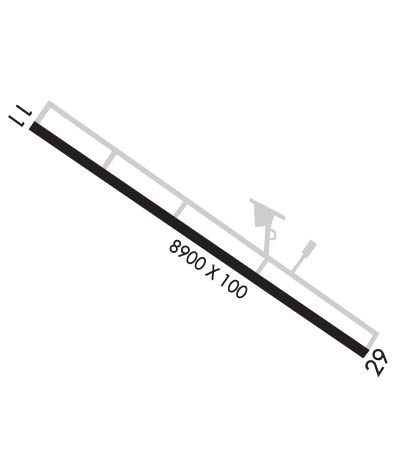
| Lat: N 4247.8 Long: W 10948.7 Elev: 7096 Var: -13 Longest Runway: 8900 | ||
| AWOS: 118.32 CTAF: 122.8 | ||
| ||||||||||||||||||||||||||||||||||||||||||||
| ||||||||||||||||||||||||||||||||||||||||||||
| ||||||||||||||||||||||||||||||||||||||||||||
| Rwy | Rwy | |||||||
| 8900x100 | 8900' | 8900x100 | 8900' | |||||
| Runway ID | Single Wheel | Double Wheel | Double Tandem Wheel | Dual Double Wheel |
| 11/29 | 45,000 | N/A | N/A | N/A |
| These numbers are Advisory and are not limits. The Airport Manager should have more accurate Weight Limits | ||||
 Airport Diagram might not be current. | |
| Facility Name: | RALPH WENZ FLD |
| City Name: | PINEDALE |
| County: | SUBLETTE |
| State abbrev: | WY |
| State Name: | WYOMING |
| Ownership: | PUBLICLY OWNED |
| Use: | OPEN TO THE PUBLIC |
| Owner's Name: | TOWN OF PINEDALE |
| Address: | P. O. BOX 709 |
| PINEDALE, WY 82941 | |
| Owner's Phone: | 307-367-4136 |
| Manager's Name: | RILEY WILSON |
| Address: | P O BOX 709 |
| PINEDALE, WY 82941 | |
| Phone: | 307-360-9025 |
| FAA Region: | NORTHWEST MOUNTAIN |
| FAA Field Office: | DEN |
| Date | Sunrise | Sunset |
|---|---|---|
| 06/12/26 Friday | 5:40 | 20:58 |
| 06/13/26 Saturday | 5:40 | 20:58 |
| 06/14/26 Sunday | 5:40 | 20:59 |
| 06/15/26 Monday | 5:40 | 20:59 |
| 06/16/26 Tuesday | 5:40 | 21:00 |
| 06/17/26 Wednesday | 5:40 | 21:00 |
| 06/18/26 Thursday | 5:40 | 21:00 |
| 06/19/26 Friday | 5:40 | 21:01 |
| 06/20/26 Saturday | 5:41 | 21:01 |
| 06/21/26 Sunday | 5:41 | 21:01 |
| 06/22/26 Monday | 5:41 | 21:01 |
| 06/23/26 Tuesday | 5:41 | 21:01 |
| 06/24/26 Wednesday | 5:42 | 21:02 |
| 06/25/26 Thursday | 5:42 | 21:02 |
| Airport Attendance Schedule | 7 Days A Week 0700-1730 |
| Airport Status | OPERATIONAL (This Status can change at any time - please check NOTAMS) |
| Airport Lighting Schedule | ACTVT ODALS RWY 11/29, REILS RWY 11 & 29, PAPI RWY 11 & 29 AND MIRL RWY 11/29 - CTAF. |
| Airport Storage Available | Tie Downs, Hanger |
| Extra Services Available | Flight Instruction |
| Wind Indicator | YES - (lighted) |
| Control Tower | NO |
| CTAF Frequency | 122.800 |
| Unicom Frequency | 122.800 |
| Rotating Beacon Color | WG |
| Segmented Circle | YES |
| Landing Fee | YES |
| Airport Inspected | STATE - performed by STATE AERONAUTICAL PERSONNEL |
| Inspection Date | 07/29/2025 |
| Type of Fuel Available | Grade 100LL, JET A (freeze point -40C); -A AVBL VIA FULL SVC ONLY.; -10AVBL H24 SELF SVC VIA CREDIT CARD. |
| Airframe Repair Service | MAJOR |
| Power Plant Repair Service | MAJOR |
| Latitude | N4247.8 |
| Longitude | W10948.7 (ESTIMATED) |
| Arpt Elevation | 7096ft (SURVEYED) |
| Magnetic Variation | 13E |
| 5 miles SE | of PINEDALE |
| Traffic Pattern Altitude | |
| Sectional Chart | SALT LAKE CITY |
| Operations (Reported) | Yearly | Avg. Daily |
|---|---|---|
| General Aviation Transient | 0 | 0 |
| General Aviation Local | 0 | 0 |
| Air Taxi | 0 | 0 |
| Commerical | 0 | 0 |
| Commuter | 0 | 0 |
| Military | 0 | 0 |
| Aircraft based on Field | |
|---|---|
| General Aviation Singles | 0 |
| General Aviation Multi | 0 |
| Jet Aircraft | 0 |
| General Aviation Helicopters | 0 |
| Military Aircraft | 0 |
| Gliders | 0 |
| Ultralights | 0 |
| FSS on field | NO |
| FSS tie-in | CASPER |
| FSS Phone | 1-800-WX-BRIEF |
| Who issues Notams | PNA |
| Notam D service at airport | YES |
| ARTCC Name | SALT LAKE CITY |
| Airport Certification | |
| Aircraft Rescue & Firefighting Index | None |
| Airport of Entry | No |
| Custom Landing Rights | No |
| Joint Civil/Military | No |
| Military Landing rights | YES |
| NATIONAL PLAN OF INTEGRATED AIRPORT SYSTEMS (NPIAS) |
| GRANT AGREEMENTS UNDER FAAP/ADAP/AIP |
| ASSURANCES PURSUANT TO TITLE VI, CIVIL RIGHTS ACT OF 1964 |
| ALL HELICOPTER TFC TO COME & GO VIA THE TWY. FLYING OVER BLDGS ADJACENT TO RAMP IS PROHIBITED. |
| ALL TWYS 50 FT WIDE. |
| FOR CD CTC SALT LAKE ARTCC AT 801-320-2568. |
Airport Communications & Frequencies:
| |||||||||
| Runway: 11 | Runway: 29 | ||
| Mag heading: | 110° | Mag heading: | 290° |
| Rwy Slope: | -.30% Down | Rwy Slope: | .30% Up |
| Approach: | Approach: | ||
| Pattern: | Left Traffic | Pattern: | Left Traffic |
| Markings: | NONPRECISION INSTRUMENT | Markings: | NONPRECISION INSTRUMENT |
| Marking Condition: | GOOD | Marking Condition: | GOOD |
| Arresting Dev: | Arresting Dev: | ||
| Lat & Long: | N4248.2 W10949.5 | Lat. & Long.: | N4247.4 W10947.8 |
| Elev: | 7096.2 ft. MSL | Elev: | 7069.4 ft. MSL |
| TCH: | 40 ft. AGL | TCH: | 40 ft. AGL |
| Visual Glide Path: | 2.83 degrees | Visual Glide Path: | 2.83 degrees |
| Displaced Threshold: | No | Displaced Threshold: | No |
| Touchdown Zone: | YES | Touchdown Zone: | YES |
| Touchdown Elev.: | 7096.2 feet | Touchdown Elev.: | 7078.4 feet |
| Visual Glide Slope: | 4-Light PAPI on LEFT side of Runway | Visual Glide Slope: | 4-Light PAPI on LEFT side of Runway |
| RVR Equipment: | RVR Equipment: | ||
| RVV Equipment: | NO | RVV Equipment: | NO |
| Approach Lights: | ODALS - omnidirectional approach lighting system | Approach Lights: | ODALS - omnidirectional approach lighting system |
| REIL: | YES | REIL: | YES |
| Centerline Lights: | NO | Centerline Lights: | NO |
| Touchdown lights: | NO | Touchdown lights: | NO |
| Runway Category: | D | Runway Category: | D |
| Declared Distances: | Declared Distances: |
Thanks for using FltPlan.com
all rights reserved © 1999-2026 by Flight Plan LLC
