
| PLATTSMOUTH MUNI PLATTSMOUTH NE |
| |
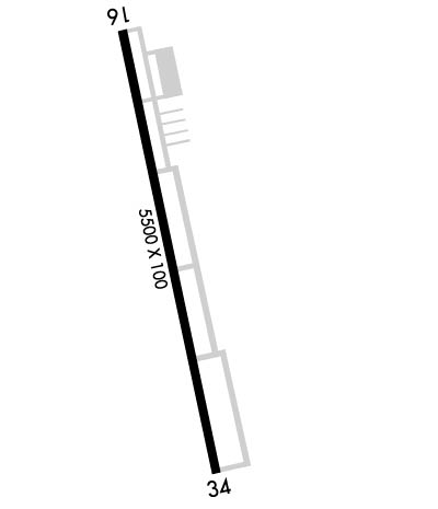
| Lat: N 4056.9 Long: W 09555.0 Elev: 1204 Var: -05 Longest Runway: 5500 | ||
| AWOS: 118.97 CTAF: 122.7 | ||
| ||||||||||||||||||||||||||||||||||||||||||||
| ||||||||||||||||||||||||||||||||||||||||||||
| ||||||||||||||||||||||||||||||||||||||||||||
| Rwy | Rwy | |||||||
| 5500x100 | 5500' | 5500x100 | 5500' | |||||
| Runway ID | Single Wheel | Double Wheel | Double Tandem Wheel | Dual Double Wheel |
| 16/34 | 30,000 | 45,000 | 90,000 | N/A |
| These numbers are Advisory and are not limits. The Airport Manager should have more accurate Weight Limits | ||||
 Airport Diagram might not be current. | |
| Facility Name: | PLATTSMOUTH MUNI/DOUGLAS V DUEY FLD |
| City Name: | PLATTSMOUTH |
| County: | CASS |
| State abbrev: | NE |
| State Name: | NEBRASKA |
| Ownership: | PUBLICLY OWNED |
| Use: | OPEN TO THE PUBLIC |
| Owner's Name: | PLATTSMOUTH AIRPORT AUTHORITY |
| Address: | P.O. BOX 128 |
| PLATTSMOUTH, NE 68048-0128 | |
| Owner's Phone: | 402-298-8468 |
| Manager's Name: | ZACH MCCULLIGAN |
| Address: | 411 CHURCH RD |
| PLATTSMOUTH, NE 68048-0160 | |
| Phone: | 402-298-8468 |
| FAA Region: | CENTRAL |
| FAA Field Office: | NONE |

| Date | Sunrise | Sunset |
|---|---|---|
| 06/08/26 Monday | 5:52 | 20:54 |
| 06/09/26 Tuesday | 5:52 | 20:54 |
| 06/10/26 Wednesday | 5:51 | 20:55 |
| 06/11/26 Thursday | 5:51 | 20:55 |
| 06/12/26 Friday | 5:51 | 20:56 |
| 06/13/26 Saturday | 5:51 | 20:56 |
| 06/14/26 Sunday | 5:51 | 20:57 |
| 06/15/26 Monday | 5:51 | 20:57 |
| 06/16/26 Tuesday | 5:51 | 20:58 |
| 06/17/26 Wednesday | 5:51 | 20:58 |
| 06/18/26 Thursday | 5:51 | 20:58 |
| 06/19/26 Friday | 5:51 | 20:59 |
| 06/20/26 Saturday | 5:52 | 20:59 |
| 06/21/26 Sunday | 5:52 | 20:59 |
| Airport Attendance Schedule | TUE-SAT 0800-1600 |
| Airport Status | OPERATIONAL (This Status can change at any time - please check NOTAMS) |
| Airport Lighting Schedule | ACTVT MIRL RY 16/34; REIL & PAPI RYS 16 & 34 - CTAF. |
| Airport Storage Available | Tie Downs |
| Extra Services Available | Parachute Jumping |
| Wind Indicator | YES - (lighted) |
| Control Tower | NO |
| CTAF Frequency | 122.700 |
| Unicom Frequency | 122.700 |
| Rotating Beacon Color | WG |
| Segmented Circle | YES |
| Landing Fee | NO |
| Airport Inspected | STATE - performed by STATE AERONAUTICAL PERSONNEL |
| Inspection Date | 04/15/2026 |
| Type of Fuel Available | Grade 100LL, JET A (freeze point -40C); -10100LL AVBL 24 HRS-SELF SERV. JET A AVBL AFT HRS ON REQ; CALL 402-298-8468 DURING ATNDD HRS. |
| Airframe Repair Service | MAJOR |
| Power Plant Repair Service | MAJOR |
| Latitude | N4056.9 |
| Longitude | W09555.0 (ESTIMATED) |
| Arpt Elevation | 1204ft (ESTIMATED) |
| Magnetic Variation | 05E |
| 4 miles SW | of PLATTSMOUTH |
| Traffic Pattern Altitude | |
| Sectional Chart | OMAHA |
| Operations (Reported) | Yearly | Avg. Daily |
|---|---|---|
| General Aviation Transient | 0 | 0 |
| General Aviation Local | 0 | 0 |
| Air Taxi | 0 | 0 |
| Commerical | 0 | 0 |
| Commuter | 0 | 0 |
| Military | 0 | 0 |
| Aircraft based on Field | |
|---|---|
| General Aviation Singles | 0 |
| General Aviation Multi | 0 |
| Jet Aircraft | 0 |
| General Aviation Helicopters | 0 |
| Military Aircraft | 0 |
| Gliders | 0 |
| Ultralights | 0 |
| FSS on field | NO |
| FSS tie-in | COLUMBUS |
| FSS Phone | 1-800-WX-BRIEF |
| Who issues Notams | PMV |
| Notam D service at airport | YES |
| ARTCC Name | MINNEAPOLIS |
| Airport Certification | |
| Aircraft Rescue & Firefighting Index | None |
| Airport of Entry | No |
| Custom Landing Rights | No |
| Joint Civil/Military | No |
| Military Landing rights | YES |
| NATIONAL PLAN OF INTEGRATED AIRPORT SYSTEMS (NPIAS) |
| GRANT AGREEMENTS UNDER FAAP/ADAP/AIP |
| ASSURANCES PURSUANT TO TITLE VI, CIVIL RIGHTS ACT OF 1964 |
| (E81) TAXIWAY TURN OFF LGTS ONLY. |
| FOR CD CTC OMAHA APCH AT 402-682-4395. |
Airport Communications & Frequencies:
| ||||||||||||||
| Runway: 16 | Runway: 34 | ||
| Mag heading: | 163° | Mag heading: | 343° |
| Rwy Slope: | .29% Up | Rwy Slope: | -.29% Down |
| Approach: | Approach: | ||
| Pattern: | Left Traffic | Pattern: | Left Traffic |
| Markings: | NONPRECISION INSTRUMENT | Markings: | NONPRECISION INSTRUMENT |
| Marking Condition: | GOOD | Marking Condition: | GOOD |
| Arresting Dev: | Arresting Dev: | ||
| Lat & Long: | N4057.3 W09555.2 | Lat. & Long.: | N4056.5 W09554.9 |
| Elev: | 1188.4 ft. MSL | Elev: | 1204.4 ft. MSL |
| TCH: | 39 ft. AGL | TCH: | 29 ft. AGL |
| Visual Glide Path: | 3.00 degrees | Visual Glide Path: | 3.00 degrees |
| Displaced Threshold: | No | Displaced Threshold: | No |
| Touchdown Zone: | YES | Touchdown Zone: | YES |
| Touchdown Elev.: | 1201.9 feet | Touchdown Elev.: | 1204.4 feet |
| Visual Glide Slope: | 2-Light PAPI on LEFT side of Runway | Visual Glide Slope: | 2-Light PAPI on LEFT side of Runway |
| RVR Equipment: | RVR Equipment: | ||
| RVV Equipment: | NO | RVV Equipment: | NO |
| Approach Lights: | Approach Lights: | ||
| REIL: | YES | REIL: | YES |
| Centerline Lights: | NO | Centerline Lights: | NO |
| Touchdown lights: | NO | Touchdown lights: | NO |
| Runway Category: | Runway with a Non-precision Approach having visibility minimums greater than 3/4 mile | Runway Category: | Runway with a Non-precision Approach having visibility minimums greater than 3/4 mile |
| Declared Distances: | Declared Distances: |
Thanks for using FltPlan.com
all rights reserved © 1999-2026 by Flight Plan LLC