
| PEMBINA MUNI PEMBINA ND |
| |
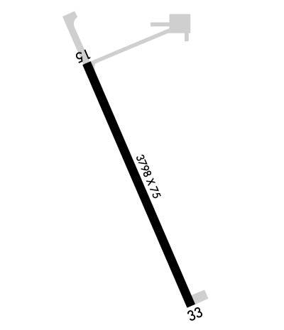
| Lat: N 4856.5 Long: W 09714.4 Elev: 796 Var: -03 Longest Runway: 3798 | ||
| CTAF: 122.8 | ||
| ||||||||||||||||||||||||||||||||||||||||||||
| ||||||||||||||||||||||||||||||||||||||||||||
| Rwy | Rwy | |||||||
| 3798x75 | 3798' | 3798x75 | 3798' | |||||
| Runway ID | Single Wheel | Double Wheel | Double Tandem Wheel | Dual Double Wheel |
| 15/33 | 12,500 | N/A | N/A | N/A |
| These numbers are Advisory and are not limits. The Airport Manager should have more accurate Weight Limits | ||||
 Airport Diagram might not be current. | |
| Facility Name: | PEMBINA MUNI |
| City Name: | PEMBINA |
| County: | PEMBINA |
| State abbrev: | ND |
| State Name: | NORTH DAKOTA |
| Ownership: | PUBLICLY OWNED |
| Use: | OPEN TO THE PUBLIC |
| Owner's Name: | PEMBINA AIRPORT AUTH |
| Address: | 10597 OLD HWY 81 |
| PEMBINA, ND 58271 | |
| Owner's Phone: | 701-825-6615; CHAIRMAN OF ARPT AUTH; MARK HATLOY 701-520-1841. |
| Manager's Name: | TERRY NORD |
| Address: | 10597 OLD HWY 81 |
| PEMBINA, ND 58271 | |
| Phone: | 701-331-4458 |
| FAA Region: | GREAT LAKES |
| FAA Field Office: | DMA |
| Date | Sunrise | Sunset |
|---|---|---|
| 06/12/26 Friday | 5:25 | 21:33 |
| 06/13/26 Saturday | 5:25 | 21:34 |
| 06/14/26 Sunday | 5:24 | 21:34 |
| 06/15/26 Monday | 5:24 | 21:35 |
| 06/16/26 Tuesday | 5:24 | 21:35 |
| 06/17/26 Wednesday | 5:24 | 21:35 |
| 06/18/26 Thursday | 5:24 | 21:36 |
| 06/19/26 Friday | 5:24 | 21:36 |
| 06/20/26 Saturday | 5:25 | 21:36 |
| 06/21/26 Sunday | 5:25 | 21:37 |
| 06/22/26 Monday | 5:25 | 21:37 |
| 06/23/26 Tuesday | 5:25 | 21:37 |
| 06/24/26 Wednesday | 5:26 | 21:37 |
| 06/25/26 Thursday | 5:26 | 21:37 |
| Airport Attendance Schedule | CONTINUOUS; FOR SVCS CTC AMGR. |
| Airport Status | OPERATIONAL (This Status can change at any time - please check NOTAMS) |
| Airport Lighting Schedule | ACTVT MIRL RWY 15/33; PAPI RWY 15 & 33 - CTAF. |
| Airport Storage Available | Tie Downs, Hanger |
| Extra Services Available | Crop Dusting, Charter, Flight Instruction |
| Wind Indicator | YES - (lighted) |
| Control Tower | NO |
| CTAF Frequency | 122.800 |
| Unicom Frequency | 122.800 |
| Rotating Beacon Color | WG |
| Segmented Circle | NO |
| Landing Fee | NO |
| Airport Inspected | STATE - performed by STATE AERONAUTICAL PERSONNEL |
| Inspection Date | 10/10/2023 |
| Type of Fuel Available | Grade 100LL; -10FUEL SVC H24 PRVDD BY AMGR FUEL TRUCK. |
| Airframe Repair Service | MAJOR |
| Power Plant Repair Service | MAJOR |
| Latitude | N4856.5 |
| Longitude | W09714.4 (ESTIMATED) |
| Arpt Elevation | 795ft (SURVEYED) |
| Magnetic Variation | 03E |
| 1 miles S | of PEMBINA |
| Traffic Pattern Altitude | |
| Sectional Chart | TWIN CITIES |
| Operations (Reported) | Yearly | Avg. Daily |
|---|---|---|
| General Aviation Transient | 0 | 0 |
| General Aviation Local | 0 | 0 |
| Air Taxi | 0 | 0 |
| Commerical | 0 | 0 |
| Commuter | 0 | 0 |
| Military | 0 | 0 |
| Aircraft based on Field | |
|---|---|
| General Aviation Singles | 0 |
| General Aviation Multi | 0 |
| Jet Aircraft | 0 |
| General Aviation Helicopters | 0 |
| Military Aircraft | 0 |
| Gliders | 0 |
| Ultralights | 0 |
| FSS on field | NO |
| FSS tie-in | GRAND FORKS |
| FSS Phone | 1-800-WX-BRIEF |
| Who issues Notams | GFK |
| Notam D service at airport | YES |
| ARTCC Name | MINNEAPOLIS |
| Airport Certification | |
| Aircraft Rescue & Firefighting Index | None |
| Airport of Entry | YES |
| Custom Landing Rights | No |
| Joint Civil/Military | No |
| Military Landing rights | YES |
| NATIONAL PLAN OF INTEGRATED AIRPORT SYSTEMS (NPIAS) |
| GRANT AGREEMENTS UNDER FAAP/ADAP/AIP |
| ASSURANCES PURSUANT TO TITLE VI, CIVIL RIGHTS ACT OF 1964 |
| CFM WINTER CONDS & SN REMOVAL BFR USE, CALL 701-331-4458 OR 701-825-6615. |
| RWY 15/33 TWY TO APRON MKD WITH REFLECTORS. |
| FOR CD CTC MINNEAPOLIS ARTCC AT 651-463-5588. |
| BIRDS & DEER ON & INVOF ARPT. |
| RWY 15/3 3 500 FT STOPWAY NORTH END. |
Airport Communications & Frequencies:
| |||||||||
| Runway: 15 | Runway: 33 | ||
| Mag heading: | 157° | Mag heading: | 337° |
| Rwy Slope: | .02% Up | Rwy Slope: | -.02% Down |
| Approach: | Approach: | ||
| Pattern: | Left Traffic | Pattern: | Left Traffic |
| Markings: | NONPRECISION INSTRUMENT | Markings: | NONPRECISION INSTRUMENT |
| Marking Condition: | GOOD | Marking Condition: | GOOD |
| Arresting Dev: | Arresting Dev: | ||
| Lat & Long: | N4856.8 W09714.6 | Lat. & Long.: | N4856.3 W09714.3 |
| Elev: | 794.7 ft. MSL | Elev: | 795.5 ft. MSL |
| TCH: | 26 ft. AGL | TCH: | 26 ft. AGL |
| Visual Glide Path: | 3.00 degrees | Visual Glide Path: | 3.00 degrees |
| Displaced Threshold: | No | Displaced Threshold: | No |
| Touchdown Zone: | YES | Touchdown Zone: | YES |
| Touchdown Elev.: | 795.8 feet | Touchdown Elev.: | 795.8 feet |
| Visual Glide Slope: | 2-Light PAPI on LEFT side of Runway | Visual Glide Slope: | 2-Light PAPI on LEFT side of Runway |
| RVR Equipment: | RVR Equipment: | ||
| RVV Equipment: | NO | RVV Equipment: | NO |
| Approach Lights: | Approach Lights: | ||
| REIL: | NO | REIL: | NO |
| Centerline Lights: | NO | Centerline Lights: | NO |
| Touchdown lights: | NO | Touchdown lights: | NO |
| Runway Category: | Runway with a Visual Approach | Runway Category: | Runway with a Non-precision Approach |
| Declared Distances: | Declared Distances: |
Thanks for using FltPlan.com
all rights reserved © 1999-2026 by Flight Plan LLC
